


| WELCOME | Pennsylvania Regional Maps 1600 To 1630 | WELCOME |
Samuel de Champlain made his first voyage to the St. Lawrence River region in 1603, and he returned several times before publishing his Les Voyages dv Sievr de Champlain in 1613. The work contains two maps of similar name of the northeastern coast that just barely include Pennsylvania. Champlain's last map of New France was published in 1632. This map definitely includes Pennsylvania; Niagara Falls is clearly shown and the slight broadening of the river above it could be considered Lake Erie. The Delaware is shown with a number of huts along it indicating villages. This map is in Fite & Freeman and an image of it can be seen at The Cartographic Creation of New England, an exhibit at the Oscher Map Library. Champlain's company is known to have coasted Lake Ontario and may have gotten to within a few miles of, or even entered, future Pennsylvania prior to explorations along the Delaware and Susquehanna Rivers. Champlain's Les Voyages de la Novvelle France Occidentale, published in 1632, contains an account of a man named Etienne Brule, who spent the winter of 1615-16 exploring south from Lake Ontario along the Susquehanna River valley accompanied by Hurons.
On April 10, 1606, the first Virginia charter was granted by James I of England. It recognized two companies, the London company and the Plymouth company, named for the cities of their origin. These companies were granted rights of settlement on the North American coast from latitude 34 to 45 degrees. The London company lands were from 34 to 41 degrees, and the Plymouth company lands from 38 to 45 degrees. A buffer zone from 38 to 41 degrees was created between the two companies where either could settle. The Plymouth company's initial attempt at a colony at Sagadahoc in Maine in 1607 was unsuccessful and no further attempt was made until the Pilgrims landed on top of 'Plymouth Rock' near Boston in 1620. The London company, subsequently called the Virginia company, established a successful colony at Jamestown in Virginia in 1607. John Smith and his companions from Jamestown were among the first European explorers to get near Pennsylvania in 1608, as Smith mapped the Chesapeake Bay and penetrated up the Susquehanna River at least as far as 'Smyths fales' located near Port Deposit, Maryland, about 7 miles from the present state border. At this point the river became too shallow and rocky for his sloop to pass. Some of Smith's party may have reached Pennsylvania if they explored any distance up the river bank. Smith's account says: "The Susquehannocks inhabit upon the chiefe spring (i.e. the Susquehanna River) of these four Branches of the bays head, two days higher than our barge could pass for rocks, yet we prevailed with the Interpreter to take with him another Interpreter to persuade the Susquehannocks to come visit us, for their language are different.... Sixty of these Susquehannocks came to us" (from Jenkins). This would be the first contact between Europeans and native Pennsylvanians. However, it appears that only Smith's Interpreter (i.e. probably a Virginia Indian) went up the river into Pennsylvania.
Henry Hudson in 1609 and Samuel Argall in 1610 are known to have anchored in Delaware Bay, but did not explore into Pennsylvania. In 1616 Cornelius Hendrickson is believed to have entered Delaware Bay using the same skiff that Adrian Block had used in 1614-15 to explore New England. The entire account of his discoveries is very short: "He hath discovered for his aforesaid Masters and Directors certain lands, a bay and three rivers, situate between 38 and 40 degrees. And did there trade with the inhabitants; said trade consisting of Sables, Furs, Robes and other Skins. He hath found the said country full of trees, to-wit: oaks, hickory, and pines, which trees were in some places covered with vines. He hath seen in the said country bucks and does, turkeys and partridges. He hath found the climate of the said country very temperate, judging it to be as temperate as that of this country, Holland. He also traded for and bought from the inhabitants, the Minques, three persons, being people belonging to this Company, which three persons were employed in the service of the Mohawks and Machicans, giving for them kettles, beads, and merchandise" (from Jenkins). These three rescued men are conjectured to have been exploring along the Delaware from the Dutch Hudson River settlements in 1615 and perhaps entered Pennsylvania.Two manuscript maps in the Dutch archives are considered to be records of Block and Hendrickson's trips. Thus, the first Europeans to enter Pennsylvania apparently did so in the year 1615 when the three captured Dutchmen and Brule (of Champlain's company) entered the state.
Sometime circa 1625, Henry Briggs, the English mathematician, wrote a treatise on exploration which included a map titled The North Part of America (Burden #214, also in Fite & Freeman and Johnson (1974)). This is a continental map and so outside discussion here, but deserves mention because it contains the first use on a map of 'De la war bay' (however see map 1624.1 below) as seen on this detail . This map is much more famous for being one of the first to show California as an island; a mistake repeated on subsequent maps.
| 1609.1 FIGVRE DE LA TERRE NEVVE, GRAND RIVIERE DE CANADA, ET COTES DE L'OCEAN EN LA NOVVELLE FRANCE Ian Swelinc fecit. I.Millot excudit. Marcvs Lescarbot nunc primum deline auit publicauit donauit. Auec priuilege du Roy (Burden #157). This map appears in Histoire de la Nouvelle France by Marc Lescarbot, who was part of the expedition that founded Port Royal in Nova Scotia in 1606. The Grand River is the St. Lawrence, of course, and this map extends south to 40 degrees and, like the later and more famous Champlain map, appears to go far enough west to include Pennsylvania. | |
|
1610.1 (Chesapeake Bay) An untitled manuscript map, dated circa 1610, of the Chesapeake Bay area is reproduced in Monumenta Cartographica Catalogue 124, published by H. P. Kraus, New York. This book is undated, circa 1960, and appears to be a sales or exhibition catalog. It is a stretch to include this map here as it would only contain a strip of southern Pennsylvania at most. However, it is one of the few maps of the area from this period. The blank land area north of the Chesapeake on the map would be Maryland and southern Pennsylvania. According to the description given, the map is thought to have been prepared by George Percy, the governor of the Virginia colony around this time. The map was prepared by a non-professional, as a comparison with the John White manuscript maps from the 1580s show. (White was a draftsman and artist.) The provenance of the map is traced back to George Legge, Baron Dartmouth circa 1680s. The original manuscript map is now apparently held at the University of Texas; the Maryland State Archives has a reproduction, MSA SC 1399-1-20. |
|
1611.1 (Northeast Coast) In 1611, Don Alonso de Velasco, the Spanish ambassador to England, sent an untitled English manuscript map to King Philip of Spain showing the east coast from Newfoundland to Virginia. Chesapeake Bay and the Susquehanna River are shown, and what appears to be the Delaware, but there is no detail. This map is in the Spanish archives and reproduced in Fite & Freeman and Stephenson & McKee. It is apparently the earliest map to show Delaware Bay (unnamed) and the information could have come from Henry Hudson's visit to the bay in 1609. Hudson was English, but he was sailing for the Dutch. Hudson was subsequently detained in England (his crew mutinied and made him sail there) and his exploration charts were confiscated or copied in England before they got back to the Netherlands. Alternatively, the information could have come from Samuel Argall, an English captain who anchored in Delaware Bay in August, 1610, on his way to Jamestown. In an account of his voyage, he calls Cape Henlopen 'Cape La Warre' and in a letter in 1613 he referred to 'the De La Warre Bay', the first use of its present name. At that time, Lord de la Warre was governor of the Virginia colony. The Velasco map shows Delaware Bay, but not the river which was not yet known about or explored. This image is from Stokes where the map is dated circa 1610. |
|
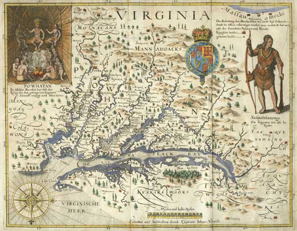
1612.1 VIRGINIA by John Smith (Burden #164). John Smith's famous 1612 map is simply titled Virginia and has north at the right. There is an inset of Powhatan in the upper left corner and the Indian is standing in Pennsylvania. 'Chesapeack Bay' lies at the center of the map and the 'Safquefabanough flu' (Susquehanna River) is shown emptying into it. A village of the same name is shown above 'Smyths fales' and the right side of the map has a large figure of an Indian given the name. This figure is based on the Indian chief who came down the river to meet with Smith. Underneath is written "The Safquefahanougs are a Giant like people thus atyred." The locations of several villages are shown with little huts in what would be Pennsylvania. This map would be imitated with increasing detail for the next 75 years. It is reproduced in Stephenson & McKee, Fite & Freeman, Pritchard & Taliaferro #5 and many other map histories. Smith also made a map of New England, but the Pennsylvania region is not shown. A discussion of this map and its many derivatives is given in Chapter 4 of Tooley, where Verner lists 12 states of the first map and 9 later derivatives. This image is from the Library of Congress copy which is state 6 from 1624. |
| 1612.2 CARTE GEOGRAPHIQVE DE LA NOVVELLE FRANSE FAICTTE PAR LE SIEVR DE CHAMPLAIN..., Champlain's famous map from his Les Voyages dv Sievr de Champlain published in 1613 (Burden #160, although published in 1613 Burden dates these Champlain maps to 1612 and that convention is followed here.). The map ends at about latitude 41 degrees and so would include part of Pennsylvania. It shows the St. Lawrence River as coming from two large connected lakes. The first is called 'Lac Contenant 15 Iournees des canaux des sauuages' (lake 15 days by canoe with the Indians, i.e. Lake Ontario), and the second called 'Grand Lac', which refers to Lake Huron, not Erie. Two other lakes are shown emptying into the river, one called 'Lac de Champlain' and presumably the present day lake of the same name, and another farther west called 'Lac des Irocois' (Lake Oneida?). According to Burden, this map is rare and usually missing from editions of Champlain's book. It may have been published separately also. Champlain's Voyages contains many large scale local maps of the St. Lawrence River area. | |
|
1612.3 CARTE GEOGRAPHIQUE DE LA NOUELLE FRANSE EN SON VRAY MERICHEIN, from Les Voyages dv Sievr de Champlain, 1613 (Burden #161). This map from the second edition of Champlain's Les Voyages... extends to latitude 40 degrees south. The longitude is 289 degrees (presumably) east of Ferro, therefore it too should include part of the Pennsylvania area in the lower left corner. This map extends farther north than the previous map, appears cruder, and may have been made first. This image is the southwest section from Winsor. |
|
1614.1 (Northeast Coast) Much of the information on Dutch maps came from the manuscript maps prepared by Adriaen Block in 1614 and Cornelius Hendricksen in 1616. What are thought to be later manuscript versions of the originals are in the Dutch archives, Algemeen Rijksarchief, The Hague. The Block map is reproduced in Schwartz & Ehrenberg, Stokes, and in Pritchard & Taliaferro #8 dated circa 1630. The entrance to the Chesapeake is at the bottom of this view and the Hudson estuary is shown. There is a narrow indentation in the coast between them which is probably the Delaware Bay although it is not named. At extreme left a river seems to continue north from this indentation beyond the neat line of the map. A reproduction of the original manuscript map, attributed to Gerrit Jacobz Witsen, is shown in Johnson (1974). This image is a facsimile from O'Callaghan, Documents relative to the colonial history of the state of New-York, Vol. 1. |
|
1616.1 (Delaware and Hudson Rivers) Cornelius Hendrickson, who explored the Delaware around 1616, is thought to be the source of this manuscript map in the Rijksarchief. The Delaware Bay is at bottom left on this view and the Hudson at upper right. This map was found along with the Block map in the Dutch archives and is attributed to Hendrickson though the manuscript version is thought to date later. It seems to have more detail of Indian names than one might attribute to this early a time. This image is a facsimile from O'Callaghan, Documents relative to the colonial history of the state of New-York, Vol. 1. |
|
1616.2 VIRGINA ET NOVA FRANCIA, (Burden #185). The 1616 edition of Petrus Bertius' book Tabularum Geographicarum Contractarum contains this map, which shows the coast from Newfoundland to Carolina. The map identifies 'S. Laurens Fluvius' and shows the 'Apalchen' which is likely where the Appalachian Mountains got their name. Burden says it appears to be extracted from Hondius' world map of 1611 as it does not contain new detail available from the maps of Smith and Champlain.This map is shown in the New England map checklist at MapForum.Com , Issue 13. The image here is from a 1618 Latin edition with text on the verso. Longitude east from Ferro. Scale: 1 inch = 500 miles. Size: 4 x 5.5 inches. |
| 1616.3 (Eastern United States & Canada) Burden discusses an untitled map (Burden #188) dated circa 1616 and believed to be a proof copy pulled from a plate later used by Pierre Duval (Burden #309, also in Schwartz & Ehrenberg). The map is attributed to Champlain and calls Lake Ontario, 'Lac S'Louis', and Lake Huron, 'Mer douce'. Lake Erie is not shown nor is any land detail. It can be seen at The Cartographic Creation of New England . The map is held by the John Carter Brown Library. | |
| 1618.1 NOVA VIRGINIAE TABVLA by Jodocus Hondius Jr (Burden #193). This is the first derivative of John Smith's map. Jodocus Jr. was the eldest son of the famous Jodocus Hondius, and he and his family carried on the business. This copy got Smith's map into the European map publishing mainstream with subsequent Latin, Dutch, French, and German text versions. Verner (in Chapter 4 of Tooley) calls this derivative 1 of Smith's map and lists versions published into the late 1600s. | |
| 1624.1 VIRGINIA NOW PLANTED, a map (Burden #213) of the east coast from Cape Fear to New England that appears as a decoration on the title page of The Generall Historie of Virginia, New-England, and the Summer Ifles..., by John Smith, now online . "B. la Ware" is identified, but nothing else in the Pennsylvania area and the map is intended to be decorative rather than informative. However, if considered as a map rather than a title page, then it may have the first appearance of Delaware Bay on a map, pre-dating the circa 1625 Briggs map mentioned above. | |
|
1627.1 VIRGINIA by Matheus Merian (Burden #219). This derivative of John Smith's map was published by Matheus Merian in 1627 in a continuation of Theodore de Bry's Grand Voyages. Verner (in Chapter 4 of Tooley) calls this derivative 3 dating to 1628 from a German edition. Image from the Heritage Map Museum CD by permission. |
|
1628.1 NOVA VIRGINIAE TABVLA Petrus Kaerius Coelavit (Burden #223). This is a derivative of Smith's map and the only regional map in the Atlas Minor Gerardi Mercatoris first published in 1628 by Jansson. This map was published in many atlas editions until mid-century; page 749 from a 1630 Dutch edition is the image shown here. There is text on the back, page 750. The only difference between this 1630 version shown and the 1628 one is the wording and page number in the top margin. This Atlas Minor map is the second derivative of John Smith's famous map, but the first to appear in an atlas according to Burden. It is listed as derivative 2 by Verner (in Chapter 4 of Tooley). This is a smaller and simpler version of Smith's map without the Indians, but still includes a swath of southern Pennsylvania. North is to the right and latitude is given, but not longitude. According to Verner, another version of this Kaerius map, called derivative 4 of Smith's map, was published in the Atlas Sive Cosmographicae in 1630; the cartouches differ from this map and there is some difference in the placement of names. Scale: 1 inch = 50 miles. Size: 5.25 x 7.5 inches. |
| 1600-1630 | 1630's | 1640's | 1650's | 1660's | 1670's | 1680's | 1690's |
| Home Page | 16th Century Maps | 17th Century Maps | 18th Century Maps | 19th Century Maps | 20th Century Maps | References |