The most interesting maps of
the late 17th and early 18th century were French. They penetrated
North America up the St. Lawrence River and through the Great
Lakes using Indian portages to reach the Ohio and Mississippi
River basins. One important portage in Pennsylvania was near Erie,
going from the lake overland to French Creek which leads to the
Allegheny River. The French eventually built Fort LeBoeuf (supposedly
named for the buffalo herds in the region) near Waterford on
French Creek to control this portage. Another important
Indian portage (not used by the French) was part of the Shamokin
Trail and went from Emporium on the Sinnemahoning Creek branch of
the Susquehanna River north to Port Allegheny on the Allegheny
River.
The English were settling on
the coast and knew almost nothing about the lands beyond the
Appalachian Mountains. Indian traders were active, but George
Washington in 1753/1754 was one of the first government officials
to penetrate the interior. He went up the Potomac River to Wills
Creek at Cumberland and then over the mountains towards the Forks
of the Ohio following an Indian path called Nemacolin's Trail,
later to be known as Braddock's Road.
| |
1700.1 THE
ENGLISH EMPIRE, from Philip Lea, Hydrographia
Universalis, London 1700? (McCorkle #700.3). The
dating of this map is uncertain and it may have appeared
in earlier editions. It shows the coastline from Cape Cod
to the Carolinas. The Chesapeake and Delaware bays are
clearly shown with their rivers wrongly described.
Pennsylvania, Philadelphia, and New Castle town are named.
See map 1685.12 for the apparent first appearance of this
small map. |
| |
1700.2 A NEW MAP
OF THE MOST CONSIDERABLE PLANTATIONS OF THE ENGLISH IN
AMERICA DEDICATED TO HIS HIGHNESS WILLIAM DUKE OF
GLOCESTER, from Edward Wells, A new sett of maps both
of antient and present geography, Oxford, theatre
1700 (McCorkle #700.9, Burden #773). Wells prepared this
atlas for school instruction at Oxford and it was not
well known until an edition of 1738. The map is
illustrated in Manasek, No. 68; and can be seen at the Darlington Library. Chester and Philadelphia
are named, nothing else. |
| |
1700.3 (Northeast)
The British Library has a large (about 3 feet by 3 feet)
manuscript map in its collections which it titles "Map
of Pennsylvania and New Jersey, with part of Long Island,"
drawn on vellum and dated to circa 1670-1700, in
Additional MS. 5414.28. Philadelphia is shown and Tinicum
Island identified, nothing else. This map is reproduced
in Cumming et al Exploration of North America in
Plate 88, also listed by Docktor
#18_A5. |
| |
1700.4 DIAGRAM OF
A LINE RUN DUE WEST PREPARATORY TO ASCERTAINING THE
WESTERN BOUNDARY OF A TRACT OF LAND PURCHASED FROM
SHAKHOPPOH AND OTHER INDIANS IN 1685, printed by Bowen
and Company, Philadelphia. A map at the Historical
Society of Pennsylvania showing the Philadelphia area.
Docktor
#200B5. |
| |
1701.1 (Maryland
& Pennsylvania) Mathews, page 265, lists a manuscript
map under this date held by the Maryland Historical
Society, which shows the running of the circular boundary
around New Castle done in 1701. The society exhibits this
map from time to time and dates it later than this, to
circa 1730. This may be similar to the map listed in
Docktor
#200A5, 200A7. |
| |
1701.2 A NEW MAPP
OF VIRGINIA, MARYLAND, PENSYLVANIA, NEW JERSEY, PART OF
NEW YORK, AND CAROLINA, by John Thornton, sold by Reeve
Williams..., by John Thornton..., and Robert Morden....
This map is dated circa 1701 by Pritchard &
Taliaferro #16. It is also discussed at the Maryland
State Archives (where it is Map #185T7) as being a later
version of a map (1685.9) Thornton first made circa 1685.
Burden #751 dates it circa 1698 which is the archive
record date on a copy in the National Archives. He also
identifies a circa 1703 print with Saml. Thornton
replacing his father. Another version of this map with
the inscription 'sold by T. Page and W. & F. Mount'
was published circa 1723-28 and is reproduced in
Pritchard & Taliaferro, and is Map #225P5 at the
Maryland State Archives. |
 |
1701.3 THE
ENGLISH EMPIRE IN AMERICA, NEWFOUND-LAND. CANADA. HUDSONS
BAY &C. in plano. Herman Moll fecit. This map is from
Moll's A System of Geography, London 1701 (McCorkle
#701.1). Pennsylvania is named along with the other
colonies. The same map appeared in The Compleat
Geographer: Or The Chorography and Topography of All
Known Parts of The Earth published by Awnsham &
John Churchill, London, 1729. Here, the map is on page 161 beginning the chapter and text follows on the verso. The color on this copy is likely
not original. Longitude appears to be east from Ferro. Scale: 1 inch = 412 miles (the scale on the map is in leagues). Size: 8.5 x 7 inches (map only). |
 |
1702.1 NOVA
SVECIA HODIE DICTA PENSYLVANIA,
Peter Lindstrom, in Tomas
Campanius, Kort Beskrifning om Provincien nya Swerige
(A Short Description of the Province of New Sweden),
Stockholm, S. Wankijfsankia 1702. This map was discussed
in the Introduction and under the 1690's.
Peter Lindstrom in 1655 made a
map titled Nova Svecia, anno 1654 och 1655, Ardenna Novae
Sveciae Carta Med, dess Riviers och Landz situation ock,
Beskaffenhet Aftagen ock till Carts, ford af P. Lindstrom.
This map was destroyed in a fire in 1697, but a copper
engraving was made circa 1696. The map also survived in
manuscript form in Lindstrom's manuscript for his Geographia
Americae. In 1702 Campanius retitled the map across
the top Nova Svecia hodie dicta Pensylvania for his book,
retaining the rest of Lindstrom's original imprint on the
bottom. This
map was reprinted several times in the 19th century. It appeared in: Arfwedson, Carl David. De Colonia Nova Suecia in Americam borealem
deducta historiola...; Praes. E. G. Geijer. Upsaliæ,1825. In
1834 Peter S. Du Ponceau translated and published the
original book in English as
A short description of the
province of New Sweden. Now called, by the English,
Pennsylvania, in America
; in 1843 the map was included
in a French encyclopedia titled Nouvelles Annales des
Voyages et des sciences géographiques, from
the Paris publisher Bertrand; and it appeared in Winsor
in 1884 which is the image here. The map is shown in
Johnson (1974) along with the title page from the book. |
 |
1702.2
NOVA SVECIAE TABULA,
ex Nic.Visscheri Del, in Tomas Campanius, Kort
Beskrifning om Provincien nya Swerige, Stockholm, S.
Wankijfsankia 1702. This map was extracted from a larger
Visscher map as the imprimatur indicates. The image shown
here is from Winsor, also shown in Egle and Johnson (1974).
The map was made to show the location of Swedish
settlements on the Delaware. It was published in the same
volume as the Lindstrom/Campanius map mentioned above.
See Egle, Phillips page 670, 671. |
 |
1702.3 VIRGINIAE
N. ANGLIAE N. HOLLANDIAE NEC NON NOVAE SVECIAE DELINEATIO.
T.C.H. SC. (McCorkle #702.4). This map also appears in
Campanius'
Kort Beskrifning om
Provincien nya Swerige. It shows the east coast from
Maine to Carolina and west to include Lake Ontario.
Philadelphia is named, but not Pennsylvania, in an area
called Nova Svecia. This image is from Winsor. |
 |
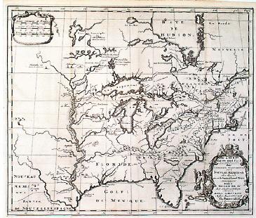
1702.4 LE CANADA, OU NOUVELLE FRANCE, LA FLORIDA, LA VIRGINIE, PENSILVANIE, CAROLINE, NOUVELLE ANGLETERRE ET NOUVELLE YORCK, L'ISLE DE TERRE NEUVE, LA LOUSISIANE ET LE COURS DE LA RIVIERE DE MISISIPI. par N. de Fer... Aves privilege du Roy 1702. Van Loon sc. A map from the Nicolas de Fer Atlas Curieux, Paris 1702 (McCorkle #702.2, 705.2). The 1705 version of this map can be seen at Pugsley
Maps from McGill University. The map is accompanied by a slightly smaller sheet with a 'Description.' The eastern (future) United States is shown from Newfoundland to the Mississippi. The coastal English colonies are delineated and named although most of their western lands are considered part of New France. The St. Lawrence and Great Lakes are well shown for so early a map; evidence the French fur traders and trappers were communicating their knowledge. Florida is called Presqu Isle de Tegeste for some unknown reason. Intaglio print, blank verso. No longitude lines although a table at the right edge gives some latitude/longitude information. Scale: 1 inch ~ 300 miles. Size: 9 x 13.25 inches.
|
| |
1702.5 A CHART OF
THE SEA COAST OF NEW FOUND LAND, NEW SCOTLAND, NEW
ENGLAND, NEW YORK, NEW JERSEY, WITH VIRGINIA AND MARYLAND.
Sold by Richd. Mount & Tho: Page at eh Postern on
Great Tower hill in London. This map is from the 1702 Atlas
Maritimus Novus by Mount and Page, who took over the
publishing from Thornton and Fisher of both the Atlas
and the English Pilot. This is a revised version
of the 1689 map of similar name. Verner notes three
states up to 1745 and two more plates up to 1794. |
| |
1702.6
CARTE DE LA NOUVELLE FRANCE OU
EST COMPRIS LA NOUVELLE ANGLETERRE NOUVELLE YORC NOUVELLE
ALBANIE NOUVELLE SUEDE LA PENSILVANIE LA VIRGINIE, LA
FORIDE..., by Jean Baptiste Franquelin. This parchment
manuscript map is listed by the National Archives of
Canada and dated circa 1702 to 1711. |
 |
1703.1 CARTE DU
CANADA OU DE LA NOUVELLE FRANCE ET DES DECOUVERTES QUI Y
ONT ETE FAITES..., by Guillaume Del'Isle. Pennsylvania
and Philadelphia just make it onto the bottom of this
French map of Canada reproduced in color in Portinaro
& Knirsch and dated 1703 (McCorkle #703.5,745.2). The
small scale map depicts the French explorations around
the Great Lakes. This image is from the National Archives
of Canada and the map can also be seen at Pugsley
Maps from
McGill University, where a 1719 Chatelain version with
the same title is also shown. |
 |
1703.2 CARTE
GENERALE DU CANADA EN PETIT POINT, by Louis Armand, Baron
de Lahontan, from his Nouveaux voyages de Mr. le
Baron de La Hontan, The Hague 1703 and later (McCorkle
#703.4, 709.1). McCorkle describes four versions and
shows 7 states of this map indicating how popular these
voyages were. Although Pennsylvania just makes it onto
the bottom of the map, it is not named. Image courtesy of
Ron Dietz. |
 |
1703.3 CARTE
GENERALE DE CANADA, by Louis Armand, Baron de Lahontan,
from his Nouveaux voyages de Mr. le Baron de La
Hontan, 1703 and later (McCorkle #703.2). This is a
larger map than the one above with more detail, though
Pennsylvania is not named. McCorkle identifies four
different plates and a still larger version (#703.3) used
in various editions of the voyages. This image is taken
from Winsor. |
 |
1703.4 (Great
Lakes and Northeast), an untitled map in the 1703 first
English edition of New Voyages to North America
byLouis Armand, Baron de Lahontan and appearing
opposite the title page per the note at top left. This
map is similar to map 1703.2 above in Lahontan's French
editions. It is characteristic of Herman Moll and has
been attributed to him. Only a slice of northern
Pennsylvania is included and not named; New York and New
England are named. The map includes the eastern part of
Lake Superior, called 'Upper Lake' and
connected to Lake Huron by a long straight broken only by
'Saut St. Maria' with a cross to indicate the
site of a mission. Only the eastern part of
'Illinefe Lake' is shown (i.e. Lake Michigan),
'Fort St. Joseph' and 'Fort
Frontenac' appear in correct locations. The St
Lawrence is shown to some distance above Quebec and the
location of the Saguenay can be identified but is not
labeled. McCorkle #703.1, who illustrates several
versions in the French editions but not this one. Blank
verso, no longitude and the latitude markings are too far
north. Scale: 1 inch ~ 200 miles or 55 leagues per the
map scale. Size: 4.25 x 6.5 inches. |
| |
1703.5 A GENERAL
MAP OF NEW FRANCE, COM. CALL'D CANADA, is Herman Moll's
version of Lahontan's map (1703.3 above) for the English
edition of Lahontan's New Voyages to North America. Here
Pennsylvania is at least named and some of the incorrect
geography of the French maps corrected. McCorkle #703.6. |
| |
1703.6 VIRGINIA
AND MARYLAND. This unattributed map is reproduced in
Papenfuse & Coale dated 1703?. It is derived from the
1673 Hermann map and resembles maps by John Thornton. It
shows the Chesapeake and Delaware Bay region and includes
southeastern Pennsylvania. Bucks, Philadelphia, and
Chester counties are identified. |
 |
1704.1 CARTE UN
TRES GRAND PAIS NOUVELLEMENT DECOUVERT DANS L'AMERIQUE
SEPTENTRIONALE ENTRE LE NOUVEAU MEXIQUE by Pieter Van der
Aa. This is the Van der Aa version of the 1697 Hennepin
map of the same title (McCorkle #704.4). It was included
in the 1704 edition of Nouvelle decouverte d'un tres
grand pays situe dans l'Amerique. Louis Hennepin was
a priest who accompanied La Salle on his explorations of
the Great Lakes and who produced several maps and many
tales of his exploits, not all true apparently, see Fite
& Freeman. Pennsylvania cannot be seen at this scale
but the map demonstrates French knowledge of the interior.
The Hennepin map can be seen at the Hargrett
Library Rare Map Collection - Colonial America
. Image from the Heritage Map
Museum CD by permission. |
| |
1704.2 (Chester
County) This surveyor's manuscript map shows the survey
of five contiguous properties in Chester County. Similar
to many others from the eighteenth century, this map is
included here as an example because it is reproduced on
page 24 in Munger. |
| |
1705.1
BATAVORUM COLONIAE OCCIDENT: INDIIS SEPTENTRIONALIS
AMERICAE IMPLANTATAE, by Johanne Baptiste Homann,
Nuremberg 1705. A small map of the northeast that is an
inset into a larger map of the Netherlands titled BELGII
PARS SEPTENTRIONALIS COMMUNI NOMINE... which Lister dates
as circa 1720. Pennsylvania and Philadelphia are named.
McCorkle (#715.2) illustrates a later version of this map
published by Peter Schenk. |
 |
1706.1
A NEW MAPP OF EAST AND WEST NEW JARSEY BEING AN EXACT
SURVEY TAKEN BY MR JOHN WORLIDGE, by John Thornton
Hydrographer at the signe of England, Scotland and
Ireland in the Minories. London. This map dated circa
1702-1707 appears in Mercator Society Publication One on
English maps and is from the Composite Atlas by
Samuel Thornton, John's son. The entire Delaware River is
shown with settlements on the Pennsylvania side named,
which can be seen in
this closeup. This image is from the
Library of Congress where the map is dated 1706. Burden #752
dates the map circa 1698 giving reasons. |
| |
1707.1 JONATHAN
DICKENSON RAMSPOEDIGE REYSTOGT VAN JAMAIKA NA PENSYLVANIA
NAGESPOORD. Uytgevoerd te Leyden door Pieter Vander Aa
met Privilegie. Jonathan Dickenson. From: van der Aa ...
Reysen Na Oost en West-Indien ... Leiden, 1707. This
weird map, with north at the left, can be seen at
MapForum.Com
, in the issue 7 checklist; and
also in Cumming et al Exploration of North America Plate
144. It can also be seen at the Darlington Library where it is dated 1696. The location of Pennsylvania is shown, nothing else.
The map includes the Caribbean islands and so would be
outside consideration here but for Pennsylvania in the
title. The Dickensons sailed from Jamaica and were
wrecked in a storm and captured by Indians in Florida.
They eventually made it to Philadelphia and the story was
one of the most popular Indian capture tales of the time.
This same map also appeared in Zee-en Landreizen der
Portuguezen, Spanjaarden, Engelsen, en allerhande natien:
zoo van Fransen, Italianeen, Deenen, Hoogh-en
Nederduitsen Als van veele andere Volkeren, Voornaamenlyk
ondernomen tot Ondekking van de Oost-en Westindien,
Midgaders andere Verafgelegene Geweften des Aardryks, written
by Johan Lodewyk Gottfried and published in 'sGravenhage
MDCCXXVII (1727). |
 |
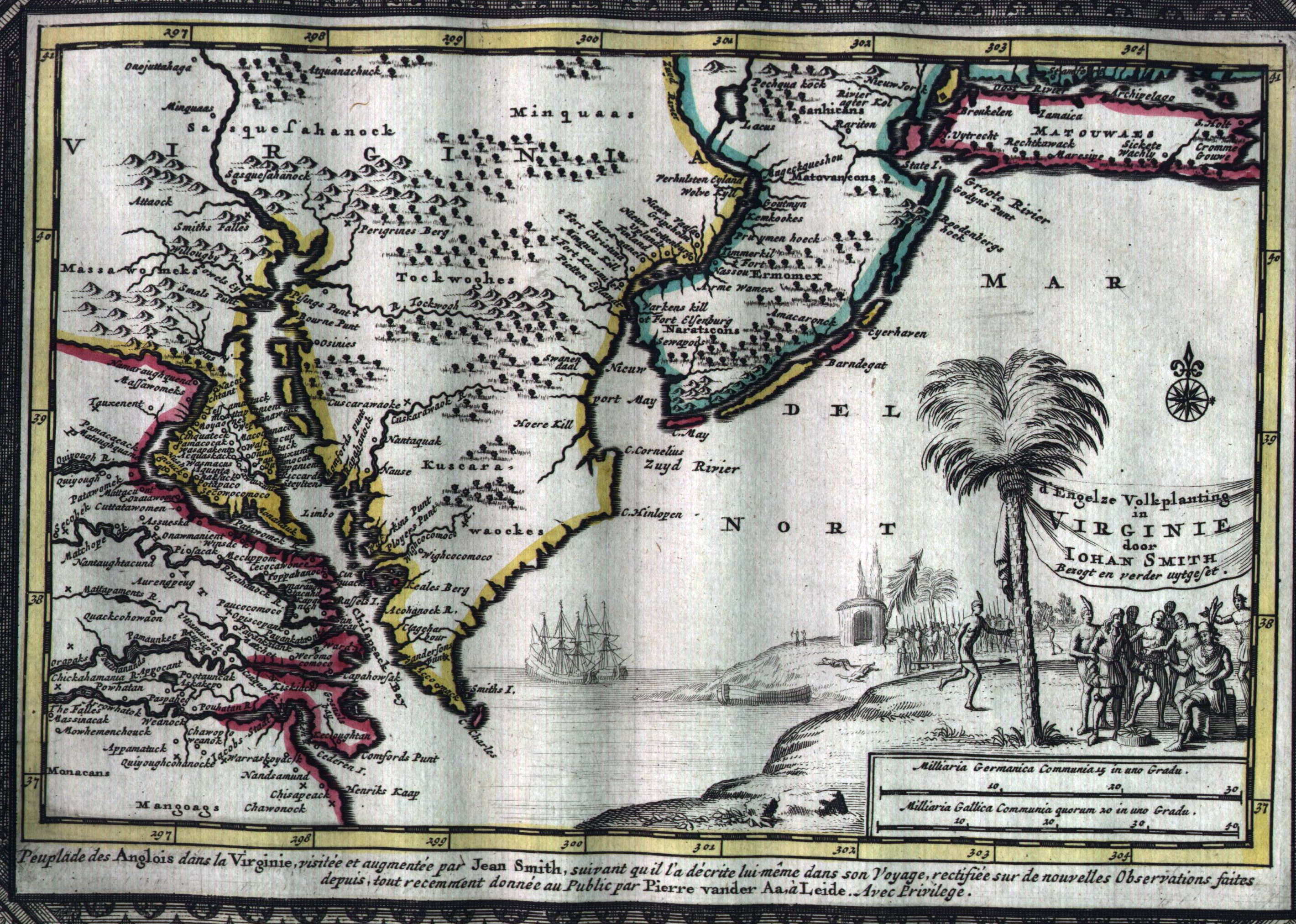
1707.2 D'ENGELZE
VOLKPLANTING IN VIRGINIE DOOR IOHAN SMITH..., by Peter
van der Aa, Leiden 1707. This small map is not a Smith
derivative and has north at the top. It covers the area
from Chesapeake Bay north to Long Island and west to the
Susquehanna. Pennsylvania and Philadelphia are not named
but Swedish and Dutch settlements along the Delaware are
indicated, so the map has been copied from a pre-1681
original. The title cartouche shows John Smith with
Indians, and the map is from Naaukeurige Versameling
der Gedenk-Waardigste Zee en Land-Reysen. McCorkle (#707.2)
illustrates the companion map to this showing New England.
Another version was published in 1714 in Atlas
nouveau et curieux by van der Aa, which is the image
shown here. It differs from the 1707 map by having an
elaborate printed border and wording along the bottom in
French which reads in part 'Peuplade des Anglais dan
la Virginie, visitee et augmentee' par John Smith
suivant quil la de crite lui-meme dans son Voyage
....' Thus the original 1707 map is in Dutch from a
Dutch publication, and the 1714 version has a French note
at bottom and is from a French atlas. Longitude east from
Ferro, blank verso. Scale: 1 inch = 52 miles. Size: 9 x
11.5 inches without the border. |
 |
1708.1 NEW
ENGLAND, NEW YORK, NEW JERSEY, AND PENSILVANIA & C.
by H. Moll Geographer, Vol. 1 page 25. This map by Herman
Moll was published in the first edition of John Oldmixon's
The British Empire in North America..., London:
printed for John Nicholson 1708 (McCorkle #708.1).
Another edition appeared in 1741; and there was also a
Dutch edition published in 1721 Het Britannische Ryk
in Amerika... . Bucks, Chester, and Philadelphia
counties are identified in Pennsylvania and were the
founding counties of the state. At the lower right is a
list of 19 towns for which only a letter was placed on
the map. The Delaware separation from Pennsylvania (1704)
is not shown. Longitude is measured east from the Ferro
meridian which passes through the Canary Islands. This
prime meridian originated with Claudius Ptolemy for whom
it was the edge of the known world. A similarly named map
appeared in Moll's Atlas Minor c1729; also c1736
per Phillips, page 671. The many states of this map are
discussed at MapForum.Com
, Issue 15. Moll was German,
but all his mapmaking was done in England, and he was the
most prolific map publisher of the time. Blank verso.
Scale: 1 inch = 42 miles. Size: 8 x 12 inches. |
| |
1708.2 A NEW MAP
OF VIRGINIA AND MARYLAND by H. Moll Geographer. This map
of the Chesapeake by Moll also comes from the Oldmixon
book and includes a strip of southeastern Pennsylvania
outlined to include the eastern half of the Delmarva
penninsula that became Delaware. The state is named but
nothing is identified. This map, like the one above, had
several versions up to circa 1740. A late version titled
just VIRGINIA AND MARYLAND is shown in Stephenson &
McKee, but includes little of Pennsylvania and ends short
of the 40th parallel. The earlier map extends slightly
above the parallel and includes more of the state. This
can be seen in side by side versions shown in Papenfuse
& Coale. Listed in Phillips, page 980. |
| |
1709.1
GENERAL=CARTE VON CANADA, a German edition of the
Lahontan map of 1703 published in Hamburg and Leipzig in
1709 and 1711 (McCorkle #709.1) |


