


| WELCOME | Articles on Historical Maps of Pennsylvania | WELCOME |
Pennsylvania in Old Road Atlases 1926 - 1930
|
|
1926 AUTO ROUTE DISTANCE ATLAS OF OHIO, MARYLAND, DELAWARE, PENNSYLVANIA, AND NEW YORK, Published by the Pittsburgh Press. Copyright by C. S. Hammond & Co. N. Y. This atlas has no issue date but can be dated to 1926 by its reference to 17 years published since 1910, similar to the dating of the 1925 Pittsburgh Press atlas shown elsewhere here. The map for western Pennsylvania is shown at left and is identical to the map in the 1925 edition, as is this two page map of the central and eastern part of the state, not all of which is shown. The images show this particular copy has a hole in it. Size: 13.5 x 10.25 inches. 2266 |
|
|
1926 BLUM'S COMMERCIAL TRAVELERS' AND TOURISTS' AUTO MAP OF PENNSYLVANIA. AUTOMOBILE EDITION. Blum's Commercial Map Pub. Co., Inc. Publishers, New York. This 26 page booklet contains an alphabetical list of towns and a hotel directory. The listing starts on the inside of the front cover, no wasted space here. The paper cover and contents are also cheap. The price was 35 cents and, as the title says, was made for salesmen to use and discard. However, there is a very nice 24 x 30 inch map of Pennsylvania attached to the back and shown at left. It includes the new 1925 state routes and inset maps of Pittsburgh and Philadelphia. Blum may have began business in San Francisco as an 1896 map was seen published by Geo. W. Blum, 330 Pine Street. These traveler's maps began earlier for travel by train. Size: 7.5 x 4.75 inches. 1397 |
|
|
1926 NUFOLD ROAD GUIDE PENNSYLVANIA NEW JERSEY WITH ADJACENT DELAWARE MARYLAND AND VIRGINIAS. United States Survey Company, Rochester, N.Y. This 1926 edition has 72 pages of city maps, ads, and travel directions. As usual, a very nice 26 x 40 inch road map is attached to the back cover and shown at left. Main routes are marked in red and both old state and modern US route numbers are used; road conditions are also indicated as paved, unpaved, and unimproved (i.e. use at your peril). Routes are arranged alphabetically by city, the first page starting with Allentown is shown here. Size: 9.5 x 5 inches. 2383 |
|
|
1926 MOTOR TRIPS TO HISTORIC POINTS IN AND NEAR PHILADELPHIA By The Motor Pathfinder. Reprinted from the Evening Bulletin, Philadelphia. This 82 page paperback book contains short articles on trips from Philadelphia originally appearing in a newspaper. This is still a popular column idea for news editors lacking good copy. Each article is accompanied by some pictures and a small map. The text gives some history as well as a description of exactly what you are looking at. Pages 21 , 22 , describe a couple day trips to Reading. Other trips go as far as the Berkshires and St. Louis. Size: 10 x 7.5 inches. 3404 |
|
|
1926 "MOTOR TRIPS" ALL OF EASTERN AMERICA FROM QUEBEC TO FLORIDA. The Guyde Publishing Co., Hartford, Conn. The pages are not numbered, but there are at least a couple hundred in this guide. In the back is a Key Map shown at left with an overlay grid to more local maps, such as Maps 80-81 showing part of northwestern Pennsylvania. There is also a fold out map showing the region of coverage from Maine to Florida. The front pages contain an alphabetical list of towns interspersed with small maps and ads. For example, this page of "S's" lists some Pennsylvania towns. This book has a 'leatherette' cover that resists cracking when bent and is well stitched for heavy use. Size: 8.5 x 5.5 inches. 3443 |
|
|
1926 MAPS OF PENNSYLVANIA CITIES AND BOROUGHS WITH ROAD GUIDE OF PENNSYLVANIA, NEW JERSEY, DELAWARE, MARYLAND, WEST VIRGINIA. Copyrighted, 1926, by City Map Co., DuBois, Pa. This 48 page booklet is filled with maps for the cities listed on page 2 . The maps are rather crude and most are small, the full page maps for Lebanon and Chambersburg shown at left are two of the larger ones. The Road Guide mentioned in the title was apparently a folded map attached to the back cover, unfortunately missing on this copy. A few pages of text include questions and answers on motoring laws, short descriptions of some major highways, and advice on visiting Harrisburg and Gettysburg. Size: 8 x 4.75 inches. 3474 |
|
|
1926 OFFICIAL AUTOMOBILE BLUE BOOK, VOL 2 1926 MIDDLE ATLANTIC AND SOUTHEASTERN STATES, PA., N.J., DEL, MD. VA., W.VA., D.C. TENN. N.C. S.C., MISS., ALA., GA., FLA. Copyright 1926 by Automobile Blue Books, Inc., Chicago. This edition contains 770 pages of the usual route directions, ads, and maps. The black cover here is not very legible, so the title page is shown at far left. A large index map of the northeast, also shown at left, is inside a plastic envelope attached by a cord. A map of the southeast is on the verso. The bulk of the book consists of route directions such as these on pages 308-309 with small maps of Erie, Meadville, and Franklin. Size: 9.25 x 5.25 inches. 3490 |
|
|
1926 CLASON'S TOURING ATLAS OF THE UNITED STATES. The Clason Map Company, Chicago, Denver. This atlas is undated but is believed to be the 1926 edition. As in the previous edition, the cover shown at far left opens to a folio size picture cover , which then opens again to show the maps. The 12 x 16 inch map of Pennsylvania is shown at left. Both trail markings and the old state route numbers are used. Size: 12 x 8.5 inches. 1304 2072 |
|
|
1926 BEST ROADS OF ALL STATES ACROSS THE CONTINENT MOTOR ATLAS. The Clason Company, Chicago, Denver. This Clason atlas can be firmly dated to 1926 since it was made for the United States Sesqui-Centennial in Philadelphia. Sights to see are shown on the back of the regular cover, shown at far left, and on the folio inside cover . The Pennsylvania map is identical to that shown above for the standard Clason atlas, so the 16 x 12 inch map of New Jersey is shown at left which includes eastern Pennsylvania in the title. Note the small Pep Boys ad on the front, a company still around servicing cars. Size: 12 x 8.5 inches. 2309 |
|
|
1926 AAA OFFICIAL TOUR BOOK AND MAP OF PENNSYLVANIA NEW JERSEY AND ADJACENT MD - DEL - VA - WVA. Pennsylvania Motor Federation, Harrisburg. This 180 page book was issued by the Harrisburg AAA club founded in 1906, but the contents are published and copyrighted by the national AAA for the first time. Previously, tour books came from local clubs; a book from the AAA club of Buffalo is shown for 1921. A 24 x 36 inch map, shown at left, is attached to the back. The front is an alphabetical list of towns with some descriptive information, many ads, and a few small maps; pages 44-45 include Hazleton and Indiana. The latter pages are route directions, some with maps and some without. A Key Map shows the routes covered, such as this route from Pittsburgh to Erie . Size: 9.5 x 5 inches. 1472 |
|
|
1926 RAND MCNALLY OFFICIAL AUTO ROAD MAP PENNSYLVANIA, Copyright 1926 by Rand McNally & Co., Chicago. Instead of an "Auto Trails" map, this 1926 edition is an "Auto Road" map, as the state had started installing route signs. Both the front and back of the cover are shown at far left. This 72 page booklet has the large 28 x 32 inch map shown at left attached to the back. The pages are an alphabetical list of towns and the combination of description, ads, and town maps is nicely illustrated here by pages 12-13 , with a map of Altoona. The Rand McNally booklet coverage of the country is shown by this United States map . Size: 7.5 x 4 inches. 2074 |
|
|
1926 SERVICE AND TOURING GUIDE ROAD MAPS OF NORTHEASTERN AND NORTH CENTRAL UNITED STATES. The maps are copyright by Rand McNally & Co., Chicago. In the mid-20s Rand McNally began making quarto size atlases, probably for several reasons. Clason had shown it was a profitable niche, customers wanted them, and the US Route system was being installed on major highways in 1926. Several of their 1926 atlases are shown here, this one of 32 pages was an ad job for Buick dealers. The Pennsylvania map (which also includes New Jersey) is shown at left. It is undated but has the "H" code for 1926. Rand McNally started this code for its road maps in 1919 with "A." The roads have a mixture of state and US route numbers; US 30 and 40 are marked, but US 22 is still marked with its state route 3. Size: 12 x 9 inches. 0414 |
|
|
1926 RAND MCNALLY OFFICIAL HIGHWAY GUIDE - NUMBER 2. Compliments of National Bank of Lawrence County, New Castle, Pennsylvania. This atlas has 16 pages and the Pennsylvania map is shown at left. It is exactly the same map used in the atlas above, as might be expected. This atlas was made for complimentary distribution like the Hammond atlases shown earlier here. Size: 12.25 x 9.25 inches. 0415 |
|
|
1926 JUNIOR AUTO TRAILS ATLAS OF THE EASTERN UNITED STATES. Compiled by Rand McNally for, and issued with the compliments of Pennsylvania Indemity Exchange, Philadelphia. Rather than use the Rand McNally cover shown above, this insurance company wanted its own in a staid respectable gray. The Pennsylvania map is identical to that in the atlases above, so some of the city maps in these 32 pages are shown here. Two maps of Philadelphia are shown at left, and maps of Pittsburgh, Lancaster, Harrisburg, Allentown, and Erie are shown here . There are several other city maps as well, plus maps of the northeast and middle Atlantic states, and a central states map. In the back is a mileage chart between cities. Size: 12.25 x 9.25 inches. 0355 |
|
|
1926 1926 EDITION NEWS AUTO MAPS EASTERN UNITED STATES AND CANADA. The News, New York's Picture Newspaper, 25 Park Avenue, New York. Copyright, 1926, by Rand McNally & Company, Chicago. This 64 page atlas with the colorful cover includes more maps than any above, but the Pennsylvania map, shown at left, is identical to those above. There are also maps of Philadelphia and Pittsburgh. This atlas covers the entire eastern United States west to the Mississippi and includes about 15 city maps as well plus a mileage chart. The price for all this was 25 cents. Size: 12.25 x 9.25 inches. 2339 |
|
|
1926 RAND MCNALLY AUTO ROAD ATLAS OF THE UNITED STATES . Copyright 1926 by Rand McNally & Company, Chicago. This is a 96 page atlas. The maps are undated but carry the Rand McNally "H" code for 1926. The two page Pennsylvania map is shown at left, and a combination of old state and modern US route numbers are used. There is a two page national map in the front and several pages of city maps in the back, including Philadelphia and Pittsburgh. This was the first year a road atlas had the 'Indian painting a rock' cover. In the mid-70s Rand McNally issued a 50th anniversary reprint of this atlas. Size: 12.25 x 9.25 inches. 4195 |
|
|
1926 PENNSYLVANIA FACTS MOTORISTS SHOULD KNOW. Department of Highways, Harrisburg, Penna. The first edition of this booklet appeared in 1925. This one has 42 pages with many photos, a few short articles, and some route directions. Near the center is the Key Map shown at left. This is followed by some more local maps, such as one of western Pennsyvania. An example of the route directions can be seen on page 14 . The articles include a welcome by Governor Pinchot, routes to take, the state parks and forests, and other touristy information. Size: 9.25 x 12 inches. 1335 |
|
|
1927 NEW 1927 EDITION AUTO ROUTE DISTANCE ATLAS OF NEW ENGLAND, NEW YORK PENNSYLVANIA AND NORTHERN OHIO. The 3rd National Exchange Bank Sandusky, Ohio. The maps are dated 1927 and copyright by C. S. Hammond & Co. New York. This 16 page complimentary atlas provided by Hammond is similar to the one shown above for 1926 with just a date addition. Pennsylvania appears on three pages; a map of the west is shown at left, with a double page map of the central and eastern sections . Although Hammond has dated some of the maps 1927, they appear identical to those for 1926 and use old state route numbers. Size: 13.5 x 10.25 inches. 2425 |
|
|
1927PENNSYLVANIA BLUM'S COMMERICIAL TRAVELERS' COUNTY MAP MAKES TRAVELING EASY. Blum Commercial Map Pub. Co., Inc. New York, N.Y. This 30 page booklet from Blum has a more colorful cover than the 1926 model, but is otherwise much the same. It can be dated to 1927 from a list of holidays on the back cover. The 24 x 30 inch folded map attached is shown at left. It is much like the 1926 road map, however this is Blum's commercial travelers' railroad map and the intent is to show rail lines, trolley lines, and bus routes as the picture on the cover indicates. The alphabetical list of towns inside remains much the same as shown by pages 6-7 . Size: 7.5 x 5 inches. 2376 |
|
|
1927 OFFICIAL NEW "MOTOR TRIPS" New England - New York - Canada Pennsylvania - New Jersey - Florida. Published by The Guyde Publishing Co., Hartford Conn. This is a later edition of the book shown above for 1926 and is much the same. There are about 300 pages of maps, routes, ads, photos. A new 32 x 20 inch foldout map is attached to the back cover; a map of New England is on one side and the mid-Atlantic with Pennsylvania on the other . The book starts with a Map Key shown at left, followed by an alphabetical list of towns, such as pages 132-133 with Philadelphia and Pittsburgh. Maps with numbers tied to the Key Map take up the second half of this book. Shown here are maps 346-347 of northeastern Pennsylvania. Size: 8.5 x 5.5 inches. 3475 |
|
|
1927 MOHAWK HOBBS GRADE AND SURFACE GUIDE SHENANDOAH VALLEY ROUTE AND CONNECTIONS APPALACHIAN SCENIC HIGHWAY. Published by Tourist Service Department of The Mohawk Rubber Company Akron, Ohio. Although folded to a 9 x 4 inch size, this 20 page booklet opens to 9 x 8 inches as shown at far left, and the route described is illustrated on a strip map. The contents are illustrated here by page 4, shown at left, with a route between Reading and Easton. Along the top is an elevation display with a small route map at the bottom. The text is mostly a list of hotels and garages with some tourist info. No route numbers are used, so this 1927 copy may be unchanged from an earlier one when route numbers did not exist. Guides like this were issued for many different routes. Size: 9 x 8 inches. 4005 |
|
|
1927 UNION AUTOMOBILE CLUB TOURING ATLAS OF THE UNITED STATES, Copyright 1927 Union Automobile Club. This atlas was made by Clason although it doesn't say so anywhere. The first give away is when the cover is folded back and a folio size cover with pictures appears, just as in the Clason atlas below. The second give away is the term "Best Roads" on the Pennsylvania map shown at left, now with US Routes identified. Note the Union logo at lower right on this map, missing from the standard Clason map shown below. Union was a California auto club based in Los Angeles. Size: 12 x 8.5 inches. 2481 |
|
|
1927 CLASON'S TOURING ATLAS OF THE UNITED STATES ONTARIO & QUEBEC. The Clason Map Company, Chicago, Denver. The United States route system was begun in 1926 and this 1927 atlas celebrated that with a big route US 40 sign on the front cover seen at the far left. The celebration also included raising the price to 75 cents. Also note the Powerine ad on the back which became a standard feature of these atlases. The folio size inside picture cover is identical to that on the atlas above. However, the Pennsylvania map shown at left and now including both old state and modern US route numbers, is just slightly different. It lacks the Union Auto logo at lower right. This atlas is number L335 in LeGear. Size: 12 x 8.5 inches. 2084 |
|
|
1927 AAA OFFICIAL TOUR BOOK AND MAP OF PENNSYLVANIA NEW JERSEY AND ADJACENT MD. - DEL. - VA. - W.VA. Pennsylvania Motor Federation, Harrisburg, Penna. Published and copyrighted by American Automobile Association, Washington D.C. This 160 page tour book is very similar to the one shown for 1926 above. The large 24 x 36 inch folded map attached is shown at left and is also much the same. Both old state and modern US route numbers are used. The route directions with strip maps are illustrated here by pages 144-145 showing routes from Pittsburgh. There are also small city maps scattered through the text. Size: 12 x 8.5 inches. 2271 |
|
|
1927 RAND MCNALLY OFFICIAL AUTO ROAD MAP PENNSYLVANIA. Copyright 1927 by Rand McNally & Company, Chicago. This 64 page booklet is much the same as the 1926 edition and both the front and back cover are shown at far left. This particular copy has a hard-to-remove green sticker on it. The large 28 x 32 inch map is also shown at left. The roads are marked with both old state and modern US route numbers. The pages contain an alphabetical list of towns with short descriptions and numerous small maps. Pages 30-31 give an example with a map of Gettysburg. Size: 7.5 x 4 inches. 0374 |
|
|
1927 RAND MCNALLY AUTO ROAD ATLAS OF THE UNITED STATES ONTARIO, QUEBEC AND THE MARITIME PROVINCES. Copyright 1927 by Rand McNally & Company, Chicago. This is a 104 page atlas. The maps are undated but carry the Rand McNally "I" code for 1927. The two page Pennsylvania map is shown at left, and a combination of old state and modern US route numbers are used. There is a two page national map in the front and several pages of city maps in the back, including Pittsburgh and Philadelphia . Size: 12.25 x 9.25 inches. 3324 |
|
|
1927 PENNSYLVANIA HIGHWAYS FACTS MOTORISTS SHOULD KNOW 1927. Department of Highways, Harrisburg, Penna. This booklet has 48 pages and is much like the previous issues with some additional routes added. The map of Pennsylvania is shown at left, and there are four large two page regional maps, like this one for the central part. Only state route numbers are used, the modern US route numbers do not appear except on a few Maryland routes. Most of the routes are given names, i.e. 1 - The Lincoln Highway, 2 - Lackawanna Trail, etc. There are several articles by state officials, some travel directions between major cities, maps of Philadelphia and Pittsburgh, and many photos. There is also this extensive mileage chart with 91 cities. Size: 9 x 12 inches. 0272 |
|
|
1927 OFFICIAL AUTOMOBILE BLUE BOOK, VOL. 3 1927 MIDDLE WESTERN STATES, PENNSYLVANIA, NEW JERSEY, VIRGINIA AND WEST VIRGINIA. Copyright 1927 by Automobile Blue Books, Inc., Chicago. This edition contains 898 pages of the usual route directions, ads, and maps. The black cover here is not very legible, so the title page is shown at far left. A large index map is inside a plastic envelope attached by a cord, however it is very similar to the 1926 version shown above. A series of route charts are in the front and the one showing Pennsylvania is shown at left. The bulk of the book consists of route directions with city and town maps such as the map of Philadelphia shown on pages 120-121 . Size: 9.25 x 5.25 inches. |
|
|
1927 NORTHEAST UNITED STATES ADJACENT CANADA NUFOLD ROAD GUIDE, published by United States Survey Company, Rochester, N.Y. This 80 page booklet is undated but uses modern route numbers and is dated circa 1927 here. It has a 27 x 40 inch black and white map folded and attached to the back cover which is shown at left. This map has an inset of upper Maine. In the text is a two-page map illustrating identified routes between cities. The pages give town descriptions and routes with mileage between towns. Size: 9.5 x 5 inches. |
|
|
1928 GALLUP'S HIGHWAY ATLAS OF THE UNITED STATES FEATURING THE MIDWEST TERRITORY. Copyright 1928 by Gallup Map & Supply Co., 1320 Walnut Street, Kansas City, Mo. This 64 page atlas contains maps of the midwest but none of Pennsylvania. However, it does have the two page eastern United States map shown at left, and a similar one of the west, plus a 'comprehensive road map' of the entire country. A combination of modern US and old state route numbers are used in Pennsylvania. The individual state maps cover the entire mid-section from Wisconsin to Texas and Indiana to Colorado. Gallup printed the Gulf Oil maps for a couple years in the late 30s, one of their other road map jobs. The company is still in business in KC. Size: 12.25 x 9.25 inches. 2094 |
|
|
1928 NUFOLD ROAD GUIDE PENNSYLVANIA NEW JERSEY WITH ADJACENT DELAWARE MARYLAND AND VIRGINIAS. United States Survey Company, Rochester, N.Y. This 68 page guide is similar to previous editions. Both the front and back of the paper cover are shown at far left. The large 26 x 40 inch folded map in the back is also shown at left. Both old state and modern US route numbers are used and the road conditions are indicated. The pages are an alphabetical list of towns with routes, ads, and small maps illustrated here by pages 48-49 with maps of Scranton and Sharon. Size: 9.5 x 5 inches. 4006 |
|
|
1928 CLASON'S TOURING ATLAS OF THE UNITED STATES AND CANADA. The Clason Map Company, Chicago, Denver. The cover changes on this 1928 edition and the Powerine ad on the back becomes much more colorful. If you want to ad color and action to an ad, use a tiger. (A not so little known trick of advertising.) However, the inside picture cover is identical to the 1927 atlas. The Pennsylvania map, shown at left, changes; the text at the edges is moved inside the map line and the "Best Roads" title is replaced by "Clason's Road Map." Both old state and modern US route numbers are used. Size: 12 x 8.5 inches. 2130 |
|
|
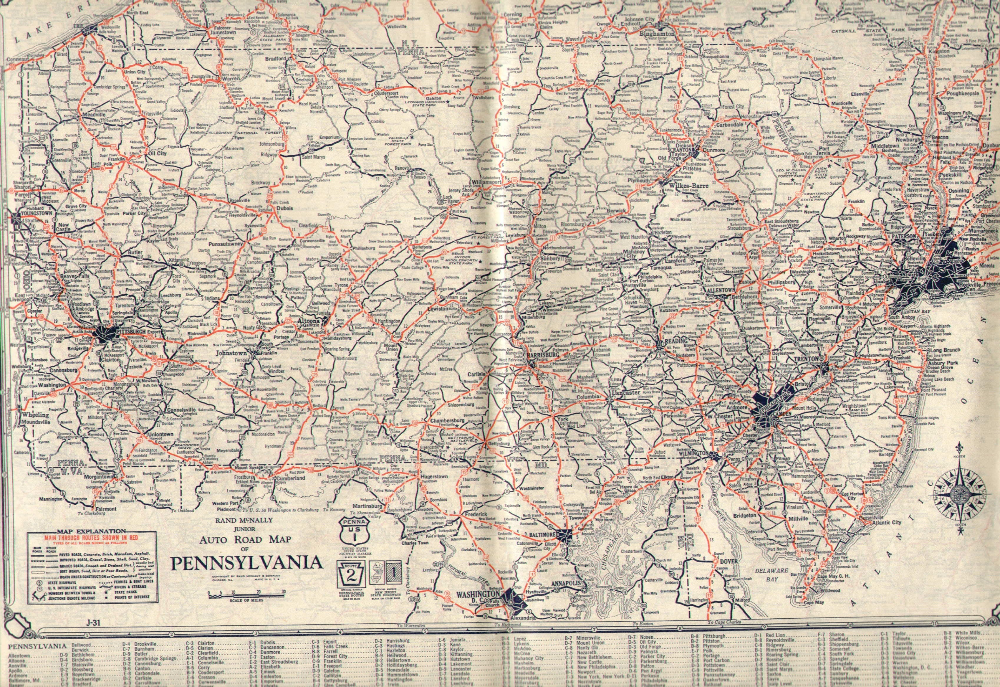
1928 RAND MCNALLY OFFICIAL AUTO ROAD MAP PENNSYLVANIA. Copyright 1928 by Rand McNally & Co., Chicago. This booklet has 60 pages with the same alphabetic listing of towns as previous editions. The text is illustrated by pages 46-47 with small maps of Punxsutawney and Reading. The large 28 x 32 inch map folded into the back is shown at left; it uses both old state and modern US route numbers. Size: 7.5 x 4 inches. 0463 |
|
|
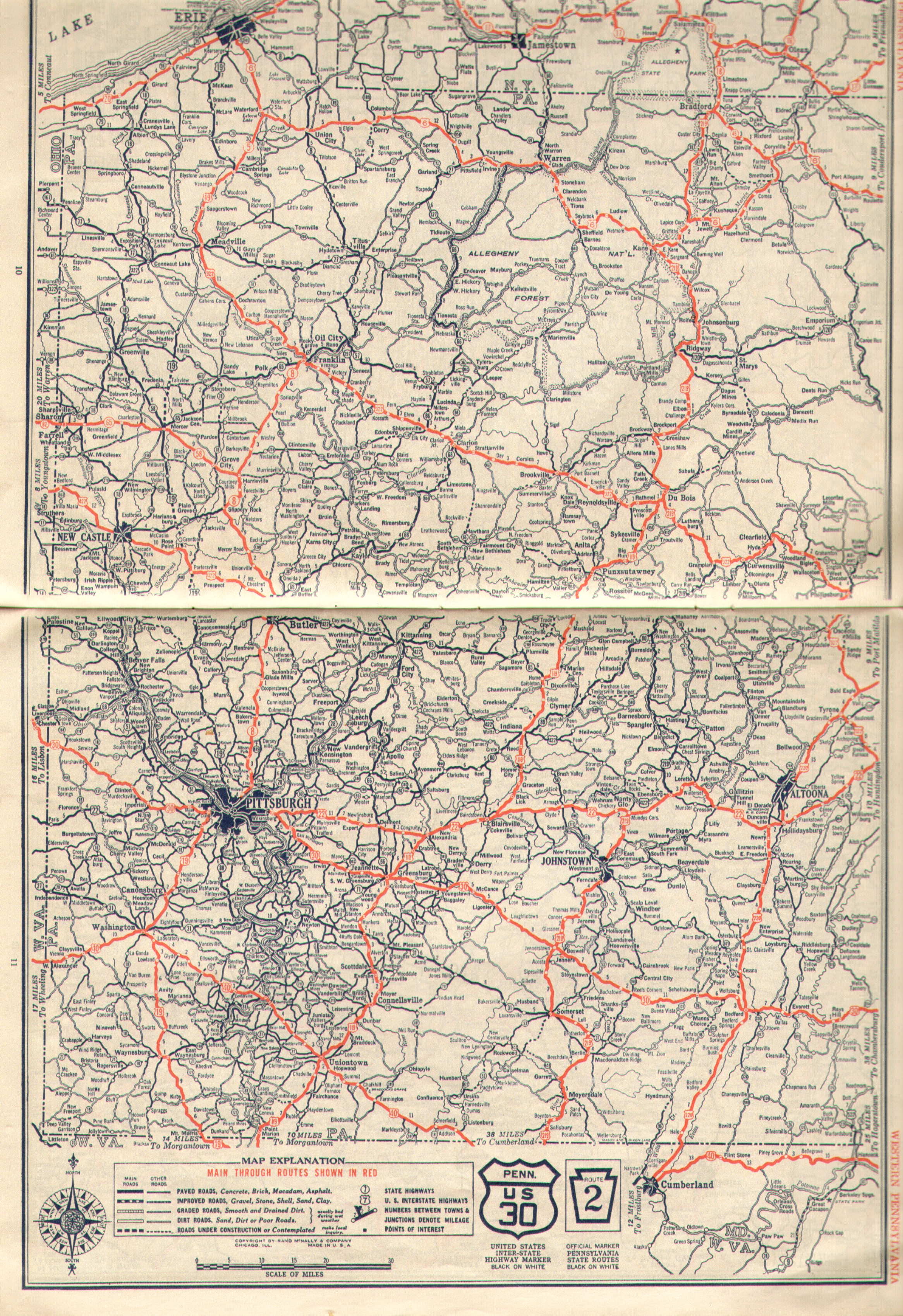
1928 THE PITTSBURGH PRESS AUTO ROAD ATLAS OF THE UNITED STATES ONTARIO AND QUEBEC. Copyright by Rand McNally & Company, Chicago. On the inside cover, the word "SPECIAL" is used for this atlas. It is undated, but the maps have the Rand McNally "J" code for 1928. This atlas is made like the ones from Clason, the front cover shown at far left opens up to 13 x 18 inch folio size pages, and the rest of this colorful cover is shown here . The Pennsylvania map, shown at left, is on a single 13 x 18 inch page and is identical to the two page one in the standard Rand McNally atlas directly below. In the back are a couple pages of city maps which include Pittsburgh and Philadelphia. Size: 13 x 9 inches folded. 2014 |
|
|
1928 RAND MCNALLY AUTO ROAD ATLAS OF THEUNITED STATES ONTARIO, QUEBEC AND THE MARITIME PROVINCES. Copyright 1928 by Rand McNally & Company, Chicago. This 104 page edition has been reorganized with states now appearing alphabetically, and the maps are all new using only modern US route numbers on major routes. The two page Pennsylvania map is shown at left; it includes New Jersey even though the state is shown elsewhere at larger scale with a two page map. The back has several pages of city maps including Philadelphia and Pittsburgh that are much like the previous edition. Size: 12.5 x 9.25 inches. 3312 |
|
|
1928 JUNIOR AUTO TRAILS ATLAS OF THE EASTERN UNITED STATES 1928. Compiled by Rand McNally for, and issued with the compliments of Pennsylvania Indemity Exchange, Philadelphia. Although the cover is the same, this 32 page complimentary atlas is changed substantially from the 1926 version shown above. It now includes a two page Historical Map of Pennsylvania (and one of New Jersey) and the state is shown by three large scale two page maps for the western (shown at left), central , and eastern sections. These maps mark routes with both the old state and modern US route numbers. There are also two page maps of New England, New York, Ontario, Quebec, Ohio, and New Jersey. In the front are a few city maps and in the back is a mileage map. Size: 12.25 x 9.25 inches. 4035 |
|
|
1928 PENNSYLVANIA HIGHWAYS. Department of HIghways Harrisburg, Penna. 1928. For the 1928 edition, this 48 page booklet was changed to a portrait, rather than landscape, format; and it has only a single map, shown at left. Only US route numbers are now given for the major highways. Like the previous editions, it contains short articles from state officials, including Governor John Fisher, and other citizens, and many photos. The travel directions are illustrated here by pages 26-27 . Size: 11 x 8.5 inches. 1131 |
|
|
1928 LANGWITH'S OFFICIAL ROAD MAP ATLAS OF THE UNITED STATES AND CANADA. This road atlas with about 17 foldout maps, was published by Langwith Publishing Company, Minneapolis. It has an unusual format with regional rather than state maps. Pennsylvania and New Jersey are on map 15 as shown here. The pages foldout to 18 x 24 inches and cover the continental United States. The 1929 Langwith atlas shown below is similar. Size: 12 x 9.5 inches. |
|
|
1928 FLACK'S TOURIST SERVICE AND GUIDE . NEW YORK STATE AND ADJACENT TERRITORY. Published by H.E. Flack - Potsdam, N.Y. Season 1928-29. This 120 page booklet has an unusual format. In the center is a double page foldout of about 60 pages with maps and photos and text; a novel way of increasing page area. In the back is an attached foldout 18 x 26 inch map, shown at left, of the area in the title including all of Pennsylvania. This is very much a New York centric product, but some of the routes described are through Pennsylvania, an example can be seen in the 1929 edition below. Size: 9.5 x 4.5 inches. |
|
|
1929 GALLUP'S HIGHWAY ATLAS OF THE UNITED STATES. Copyright 1929 by Gallup Map & Supply Co., 1320 Walnut Street, Kansas City, Mo. This 64 page atlas has the same cover as the one for 1928 above and Gallup used this same cover for several years. Many of the states are covered in a two page map including Pennsylvania shown at left. There is a national map and a few small city maps scattered thoughout including one of Philadelphia - Camden. Modern route numbers are used. Size: 12.25 x 9.25 inches. 1499 |
|
|
1929 CLASON'S TOURING ATLAS OF THE UNITED STATES AND CANADA. The Clason Map Company, Chicago, Denver. The 1929 and 1930 Clason atlases apparently had the same cover design, however this is believed to be the 1929 edition. The cover, shown at far left, has changed from 1928 but the Powerine ad is the same. The inside picture cover has also changed. The Pennsylvania map is shown at left and the old state route numbers are now gone from the major US routes. Size: 12 x 8.5 inches. 3011 |
|
|
1929 ROADS AND ROUTES THE UNITED STATES AND CANADA. Prepared by "Brownie" Director of The Milwaukee Journal Tour Club. Copyright by Langwith Publishing Company, Minneapolis, Minn. This was probably a special order Langwith atlas sponsored by the Milwaukee Journal newspaper. It has an unusual construction explained on the inside cover along with the map coverage. The tipped in maps unfold twice to a 17.5 x 24 inch size. Pennsylvania and New Jersey are combined on one map and the state is shown here in eastern and western sections. In the back is a large scale map of the Milwaukee area and two maps of the United States. Size: 12 x 9.5 inches. 2362 |
|
|
1929 AUTOMOBILE ALA GREEN BOOK Road Reference and Tourists' Guide of All States East of the Mississippi River, Eastern Ontario, Quebec and Maritime Provinces. Published by Scarborough Motor Guide Company, Boston. The 1919 edition of this book is also shown here, and is much smaller with a different publisher. The lettering on the green cover here is hard to see, so the title page is shown at far left. This book has 932 pages which include: 96 pages of Detail Maps, 100 City Traffic Maps, 2 folded Key Maps and Mileage Charts in an evelope in the back, and many pages of routes between towns. The 19 x 24 inch folded map that includes Pennsylvania is shown at left. The route numbers used in this book are shown on the map and they are not the same as state or US route numbers. A listing of routes is included and pages 52-53 include Pennsylvania. In the back are pages of Detail Maps with an Index Map , the north central part of the state is shown on pages 776-777 . The route directions are illustrated here by pages 510-511 describing the route between Pittsburgh and Erie. This book also includes in its many pages an Abstract of Automobile Laws, a Golf Club Directory, Ferry Schedules, an Index of Principal Cities and Towns, and a hotel directory. Size: 9 x 5.5 inches. 3434 |
|
|
1929 GRANT'S AUTO ROUTE GUIDE, VOL. 1. NORTHEASTERN SECTION. Published by the Nomad Publishing Company, Inc. New York. Copyright 1929 by Homer D. Grant. This 192 page book has grown slightly and has a different publisher from the 1925 edition shown elsewhere here. In the front of the book is a Key Map, partially shown at left, to numbered routes covered. The coverage extends south to Maryland and west to Wisconsin. There are now 30 pages of route maps, such as Map 7 of south central Pennsylvania, and 119 special city maps, such as on pages 74-75 with small 1.5 x 1.5 inch maps of Reading and Lancaster; and the route directions given are just mileages between towns. Size: 9 x 4.25 inches. 4032 |
|
|
1929 RAND MCNALLY OFFICIAL HIGHWAY GUIDE. Compliments of Hotel Olds, Lansing, Michigan. This No. 3 guide appears to be Rand McNally's standard complimentary atlas for 1929 and is dated from the "K" code on the maps. The two page Pennsylvania map is shown at left and is the same map that appears in the Rand McNally road atlas below. This guide has 16 pages and its only contents are the state maps listed on the cover. Size: 12.5 x 9.25 inches. 1455 |
|
|
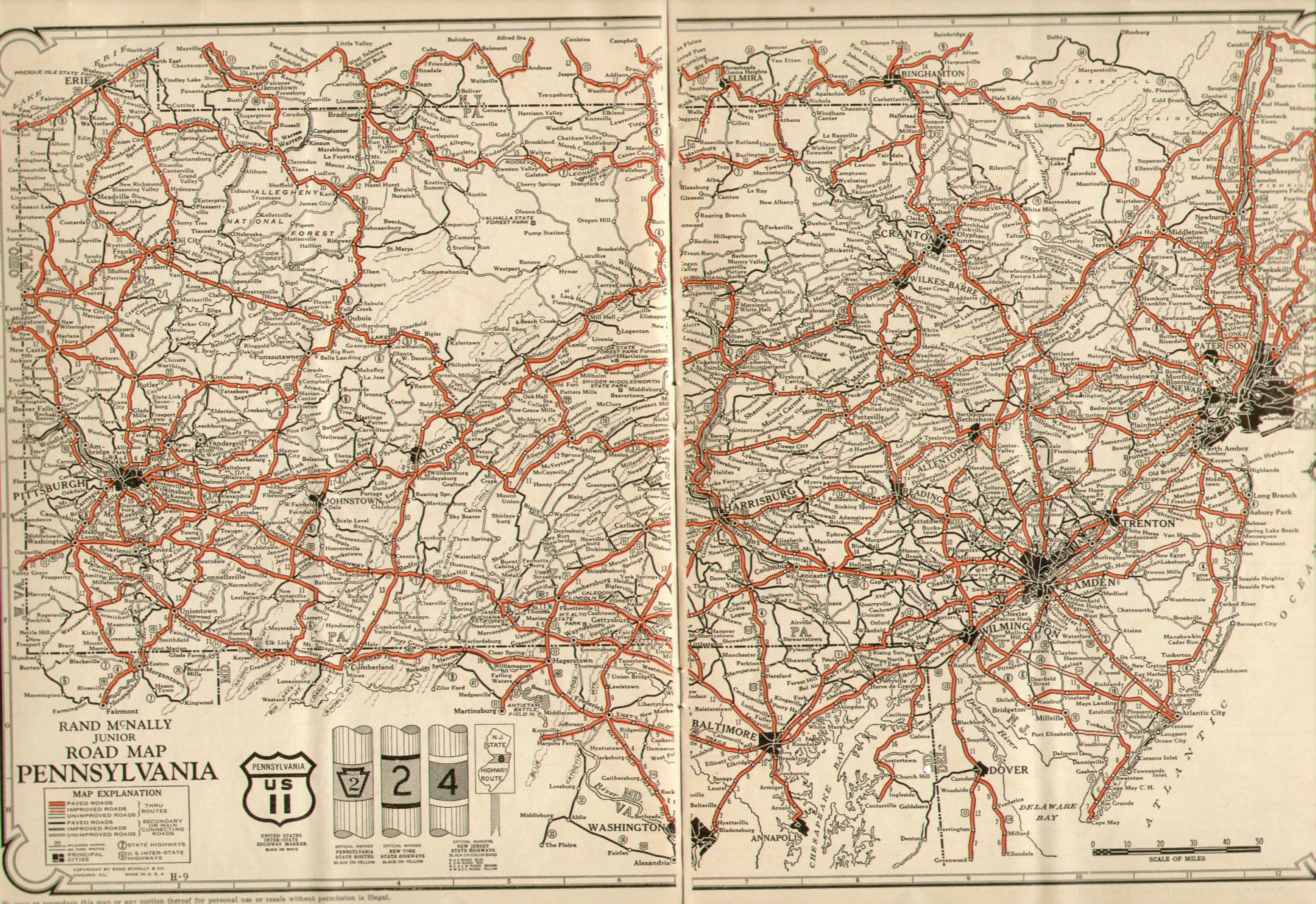
1929 RAND MCNALLY OFFICIAL AUTO ROAD MAP PENNSYLVANIA NEW JERSEY. Copyright 1929 by Rand McNally & Co., Chicago. This booklet is 72 pages with the large 28 x 32 inch Pennsylvania map shown at left. Both the front and back cover are shown at far left with Coca Cola replacing Gulf as the back cover ad. The text remains much the same as before, an alphabetical list of towns with small maps, ads, and tourist info, illustrated here with pages 36-37 and maps of Johnstown and Lancaster. Size: 7.5 x 4 inches. 2095 |
|
|
1929 RAND MCNALLY AUTO ROAD ATLAS OF THE UNITED STATES. A Map of Every State in the United States and Every Province of Eastern Canada. Copyright 1929 by Rand McNally & Company, Chicago. The cover text is slightly different on this 104 page atlas, but the Pennsylvania map, shown at left, is almost identical to the 1928 map, though it does carry the 1929 Rand McNally "K" code. In the back are some pages of city maps, including Philadelphia and Pittsburgh . These city maps differ from those included in previous years. Size: 12 x 9 inches. 3116 |
|
|
1929 PENNSYLVANIA HIGHWAYS 1929. Department of Highways, Harrisburg, Penna. This 50 page booklet is much like the previous year as is the single two page map shown at left. The nature of the short articles can be seen in this example on highway problems by the state's chief engineer. Size: 12 x 9 inches. 0375 |
|
|
1929 PENNSYLVANIA TOURS Good Roads - Beautiful Scenery - Historic Shrines - Hospitable People. Issued by Pennsylvania State Publicity Bureau, State Chamber of Commerce. Harrisburg, PA. Copyright 1929 by T.C. Mirkil. According to the text, this is the fifth edition of this 140 page booklet. At the back is an index map and 16 pages of sectional maps, one for the northwest is shown at left. The text is full of strip maps, ads, photos, and town information. The organization is around routes, and Route 219 crossing the state in the west is shown on pages 62-63 , 64-65 , along with an aerial photo of Johnstown. Size: 10 x 7 inches. 2381 |
|
|
1929 KEYSTONE AUTOMOBILE CLUB EDITION OF THE BLUE BOOK STANDARD TOURING GUIDE OF AMERICA 29TH YEAR VOL. THREE MIDDLE ATLANTIC STATES AND OHIO. This 160 page book contains maps, route directions, and ads as in past blue books. However, a format and size change has occurred. Whether this change is general or a special edition for the Keystone Automobile Club is not known. In the front is a two page route map of the covered area, followed by a two page mileage map shown at left. The front part of the book is divided into sections with a general section map and small city maps as shown on pages 24-25. This part may be unique to this auto club edition. Beginning on page 75, the rest of the book is text on sights, with no route descriptions as in earlier volumes. The end page map shows the nine regions covered by different blue book volumes, this one being volume three. Size: 9.5 x 7.5 inches. |
|
|
1929 FLACK'S TOURIST SERVICE SCENIC GUIDE NORTHEASTERN STATES - EASTERN CANADA. Published by H.E. Flack, Potsdam, N.Y. 1929-1930. This is a later version of the 1928 edition shown above. There are now 144 pages with a few additional routes added, although this is still primarily a New York guide. An example of the text is a route from Binghamton to Philadelphia shown here and here. As in the previous edition, there is a central sheaf of pages at double size. Attached to the back is the same map as shown in the 1928 edition above. Several small town and city maps are included, none of Pennsylvania; so an example is the map of Niagara Falls shown at left. Size: 9.5 x 4.5 inches. |
|
|
1930 LANGWITH'S OFFICIAL ROAD MAP ATLAS OF THE NORTH EASTERN UNITED STATES. Copyright by A.L. Langwith, Minneapolis. This atlas is undated; it uses modern route numbers and appears to be circa 1930. There are just four folded sheets or eight pages inside, but they open out to a 12 x 17.5 inch near folio size. New England, New York, New Jersey, Pennsylvania, and Ontario are covered. Pennsylvania is given two of the large pages, for east and west . Size:12.25 x 9.5 inches. 3129 |
|
|
1930 OFFICIAL PAVED ROAD AND COMMERCIAL SURVEY OF THE UNITED STATES. National Map Company, Indianapolis. Edition 1262. The significance of this edition number is not known; a 1928 edition of this atlas is dated and similar. This 115 page undated folio size atlas uses 1920 census data and is believed to date circa 1930. Its similarity to the 1923 Cram road atlas is striking and indicates that National Map had obtained the publishing rights after taking over Cram in the early 20s. However, the title page changes "Auto Trail" to "Paved Road" and the organization is different. The first few pages are "Sectional Paved Road" maps and the one with Pennsylvania is shown at left. The main section contains typical atlas railroad maps, illustrated by the Pennsylvania map on pages 36 , 37 . In the back is a gazetteer of towns and a description of each state. Size:15 x 12 inches. 3446 |
|
|
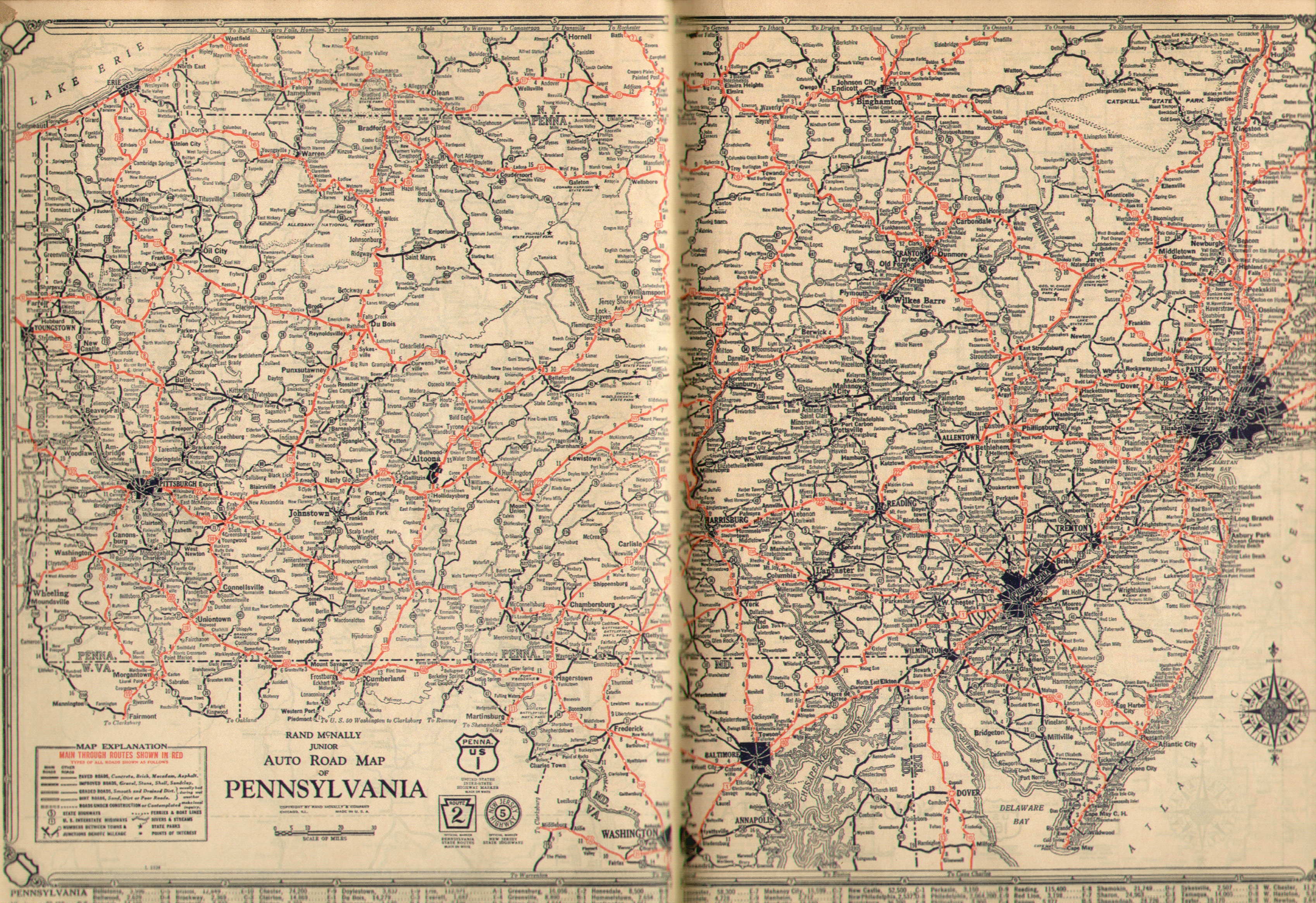
1930 RAND MCNALLY OFFICIAL AUTO ROAD MAP PENNSYLVANIA NEW JERSEY. Copyright 1930 by Rand McNally & Co., Chicago. This 72 page booklet is much like the previous years. Both the front and back cover are shown at far left, and the 28 x 32 inch Pennsylvania map folded into the back is shown at left. The text remains the same with an alphabetical list of towns with maps, ads, and info. Pages 66-67 contain maps of Warren, Washington (PA), and Wilkes-Barre, for example. The national coverage of these booklets in 1930 is shown by this small United States map . Size:7.5 x 4 inches. 2354 |
|
|
1930 PENNSYLVANIA INDEMNITY CORPORATION PHILADELPHIA AUTO TRAILS ATLAS 1930. Copyright by Rand McNally & Company. This is a complimentary 32 page atlas that uses the client's cover design and previous editions are shown above. Pennsylvania is covered in three two page maps of the western , central , and eastern regions. There are also a few city maps in front including Philadelphia and Pittsburgh. In the back are two maps of the eastern United States; the state maps include two page maps of Ohio, New York, New Jersey, New England, Delaware-Maryland-Virginia-West Virginia, Ontario, and Quebec. Size:12.25 x 9.25 inches. 3274 |
|
|
1930 RAND MCNALLY AUTO ROAD ATLAS OF THE UNITED STATES. A Map of Every State in the United States and Every Province of Eastern Canada. Copyright 1930 by Rand McNally & Company, Chicago. This 104 page atlas is very similar to the previous year. The Pennsylvania map is shown at left and carries the "L" code for 1930, but also the date 1928, and it is almost identical to that year's map. The city maps are also much the same as 1929. The use of the distinctive Indian cover on these atlases ended with the 1931 issue. Size: 12.75 x 9.25 inches. 3350 |
|
|
1930 MOTOROAD ATLAS OF UNITED STATES. Prepared by Rand McNally & Co. for F.W. Woolworth Co. Copyright 1930 by Rand McNally & Company, Chicago. This is a 96 page road atlas with reduced sizes of the regular Rand McNally atlas maps, and is an early example of a 'glove compartment' atlas. The two page Pennsylvania map is shown at left with an inset of the Philadelphia region. Both the front and back covers are shown at far left. Size: 9.25 x 4.25 inches. 3435 |
|
|
1930 PENNSYLVANIA HIGHWAYS. Department of Highways, Harrisburg, Penna. The first edition of this booklet appeared in 1925. This one has 50 pages with many photos, a few short articles, and some route directions. Near the center is the only map shown at left. On the back cover are a photo of the State Capitol building and some office buildings, and some photos of courthouses ( for more see County Seats & Courthouses ). Size: 11.75 x 8.75 inches. 1173 |
|
|
1930 CLASON'S TOURING ATLAS OF THE UNITED STATES AND CANADA. The Clason Map Company, Chicago, Denver. The 1929 and 1930 Clason atlases apparently had the same cover design, and this is believed to be the 1930 edition. The only difference in the cover, shown at far left, is the underlining of the words at the top; the Powerine ad is the same. The inside picture cover appears identical to the previous edition. The Pennsylvania map is shown at left and also appears unchanged. Size: 12 x 8.5 inches. 4458 |
|
|
1930 RAND MCNALLY STATE AND FEDERAL ROAD GUIDE OF THE UNITED STATES. Copyright 1930 by Rand McNally & Co., Chicago. This 64 page road atlas has reduced size maps and is apparently another attempt at a more convenient "glove compartment" size similar to the atlas with the red cover shown above. The two page Pennsylvania map is shown at left with an inset of the Philadelphia region.The maps have the "L" code for 1930 and appear the same as those in the atlas above. This atlas has a city map section in the back with maps of Pittsburgh, Erie, Washington (PA) and Philadelphia, Harrisburg, Scranton. Size: 9.25 x 8.5 inches. |
|
|
1930 GALLUP'S HIGHWAY ATLAS OF THE UNITED STATES & CANADA. Copyright 1930 by Gallup Map & Supply Co., Kansas City. This 72 page atlas contains state, province and some city maps including Philadelphia and Pittsburgh; and the maps are much like those from previous years as the map of Pennsylvania and New Jersey at left shows. Gallup changed the cover design however, and there is a department store ad on the cover of this copy, probably an over stamp, and a couple small holes. Size: 14 x 11 inches. |
Copyright 2009 by Harold Cramer.
All rights reserved.
Revised September, 2010; September, 2011; August, 2013; August, 2019: February, 2021; January, 2022.