| WELCOME | Pennsylvania Early County Map List | WELCOME |
The ‘very’ earliest county map is the 1687 map of Thomas Holme, A Mapp of Ye Improved Part of Pennsylvania in America divided into Countyes Townships and Lotts. This map showed the counties of Philadelphia, Chester, and Bucks, the founding counties of the state created in 1682. However, it and the subsequent maps of Philadelphia during the 18th century fall more into the state or city, rather than county, category.
County maps of the 19th century are listed below. The earliest county land ownership map is A Map of Wayne and Pike Counties, prepared in 1814 by Jason Torrey, and considered the first such map ever made in the United States (see Couzen in Wolter & Grim). The map, shown here in a Library of Congress copy , was accompanied by a pamphlet titled An Index to the Map of Wayne and Pike Counties, which listed the land owners identified only by number on the map.
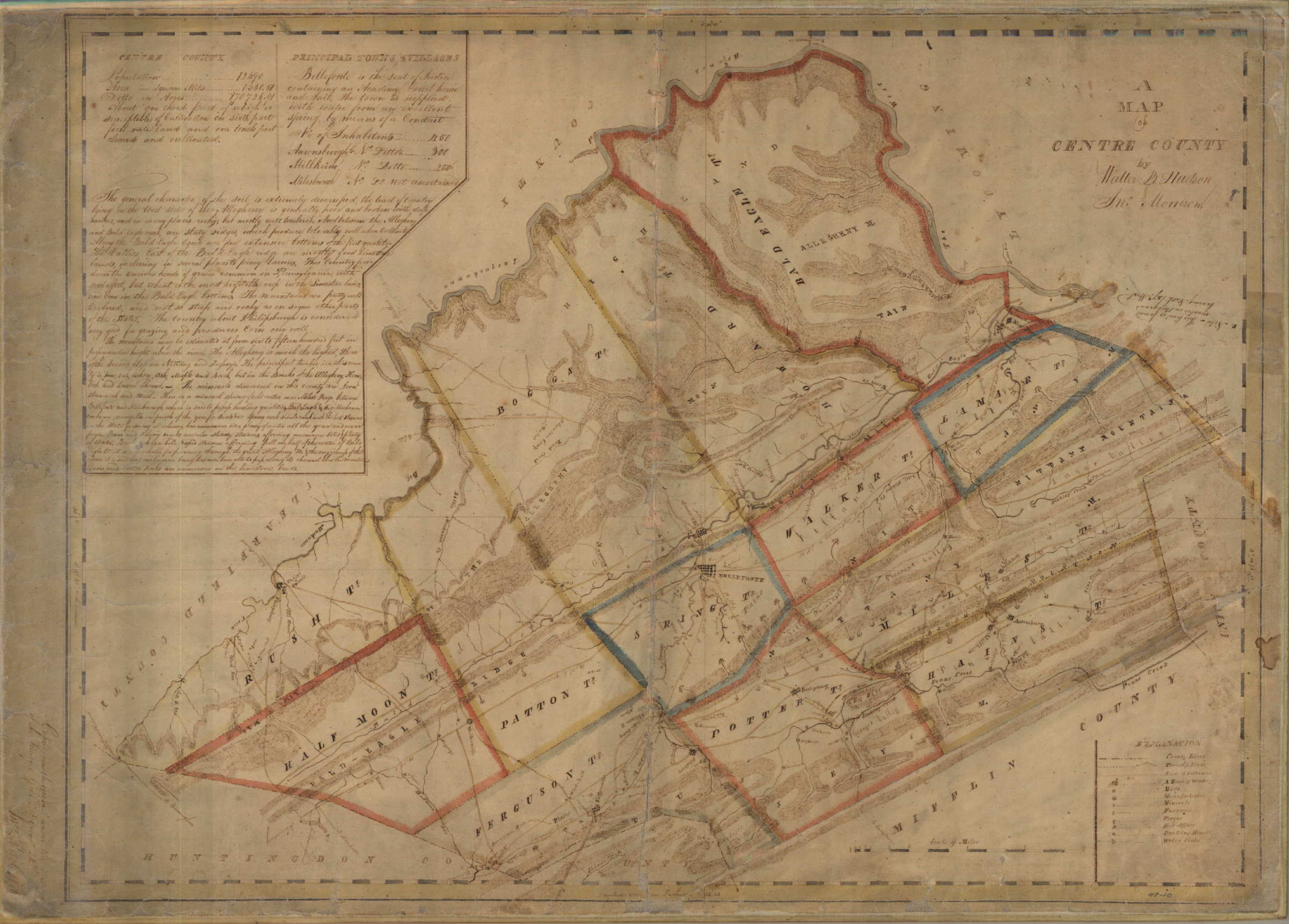
In March 1816, the legislature passed an act “for the formation of a map of each of the counties within this commonwealth.” Completed from 1816 to 1820, these maps were based upon actual county surveys with township boundaries, roads and distances, post offices, mills, factories, iron furnaces, iron forges, churches. Deputy surveyors did most of the work and a clerk in the Land Office, the first of whom was John Whiteside, made office copies of these for the Surveyor General; so they are sometimes called the “Whiteside Maps.”An example of a Whiteside map is this image of Centre County. These county maps were used to create a definitive state map under the direction of John Melish, which was published in 1822. Melish entertained the grand idea of creating a state atlas presenting all of the county maps and entered into an agreement in April 1821 with Philadelphia engraver Benjamin Tanner for publication. However, few of the county maps were ever engraved and published, probably due to Melish’s death in 1822. The original surveyor maps were never returned to the Surveyor General and today the State Archives has only the Whiteside copies. Forty-four of these manuscript county maps are preserved in the archives and are included in the list below. Some are accessible at libraries in photographic reproduction and scanned images of all are available at the Pennsylvania Archives.
In 1822, Melish published a catalog of maps for sale; eight county maps are listed: Philadelphia, Montgomery, Chester, Berks, Dauphin and Lebanon, Huntingdon, Somerset, Wayne and Pike. The Philadelphia county map published by Melish is reproduced in Ristow on page 114. For more on the Melish state and county maps, see Babinski.
The classic county wall maps were published from around 1850 to 1870. They were a direct precursor to the county atlas. However, not all the maps after 1850 listed here are, strictly speaking, wall maps. Also, some maps after 1860 titled 'Oil Region' may show more than one county and probably deserve a category of their own. The many county maps prepared circa 1880 as part of the Second Geological Survey are not included. The list was compiled from the holdings of the Library of Congress, the Pennsylvania State Archives, and internet library searches. Most of the maps listed below, as well as others, can now be seen at the Pennsylvania State Archives website on maps. This page has been updated with additional links by Penn State Library.
| County | Year | Map Title |
|---|---|---|
| Adams | 1821 | See York county |
|
|
1858 | Map of Adams County, Pennsylvania. From Actual Survey by G. M. Hopkins, C.E. 1858. M. S. & E. Converse Publishers. 517, 519, 521 Minor Street, Philadelphia. Entered according to Act of Congress in the year 1857, by Robert P. Smith in the clerks office of the district court of the eastern district of Pennsylvania. Entered According toAct of Congress in the year 1858 by M. S. & E. Converse, in the Clerk's Office of the District Court of the Eastern District of Pennsylvania. Printed, in 3 colors. 38 x 53 inches. PSA#22, LOC S#697, LOC Phillips p. 91. LOC copy. |
| Allegheny | 1817 | The Map of Allegheny County by David Dougal & Jno. E. Whiteside. Pennsylvania Dept. of Internal Affairs Bureau of Land Records. Manuscript map copied from the original under the direction of the Surveyor General May 19, 1817, Jno. E. Whiteside. Reproduction of film of an original remaining on file in the Land Office of the Department of Internal Affairs of Pennsylvania. 20 x 17.5 inches. LOC S#698, OCLC:33598824 |
|
|
1851 | Map of Alleghany Co. Penn. With the names of property-holders. From actual surveys by Sidney & Neff and S. M. Rea. Col fold. 44 x 44. Philadelphia 1851. LOC Phillips p. 98, LOC S#699 |
|
|
1855 | Map by Sidney, Neff, S. M. Rea & L. H. Norfolk (Coast Survey Coll.), R. L. Barnes, Phila. 14 parts, 17 x 13 ea. LOC S#700 |
|
|
1862 | Map of Allegheny County, Pennsylvania From Actual Surveys by S. N. & F. W. Beers. A. B. Brindle, C. S. Warner & J. M. Beers Assists. Smith, Gallup & Hewitt, Publishers, 517, 519 & 521 Minor Street, Philadelphia. 1862. F. Bourquin & Co. Lithographers Est. 602 Chestnut Street, Philadelphia. Worley & Bracher. Liths. 602Chestnut Street, Philadelphia. Scale 1 1/2 inch to the Mile. Printed, in 4 colors. PSA#30, LOC S #701 |
|
|
1883 | Map of Allegheny County, Alex. Y. Lee, Otto Krebs, Pittsburgh. 59 x 57.5. LOC S#702. |
|
|
1890 | Allegheny & parts of Westmoreland, Washington & Beaver counties, 1890. Otto Krebs, Pittsburgh. 6 sheets, 23.5 x 35 ea. LOC S#703 |
|
|
1898 | Allegheny County, Chas. T. Rainey. 33 x 35. LOC S#704 |
| Armstrong | 1817 | A map of the county of Armstrong by Orr, Robert, 1786-1876, Whiteside, Jno. E., Pennsylvania Dept. of Internal Affairs. Manuscript map, copied from the original under the direction of the Surveyor General, May 20, 1817, Jno. E. Whiteside. Reproduction of film of an original remaining on file in the Land Office of the Department of Internal Affairs of Pennsylvania. OCLC:33598717 |
|
|
1861 | Map of Armstrong co. Pennsylvania. From actual surveys by G. M. & H. W. Hopkins. Fold. 56 x 47. Philadelphia, A. Pomeroy & S. W. Treat, 1861. LOC Phillips p. 125, LOC S#705 |
| Beaver | 1817 | A correct map of Beaver County, by Hugh McCullough;Jno. E. Whiteside. Pennsylvania Dept. of Internal Affairs. Manuscript map, copied from the original under the direction of the Surveyor General April 25, 1817, M. E. Whiteside. Reproduction of film of an original remaining on file in the Land Office of the Department of Internal Affairs of Pennsylvania. 53 x 39 cm. OCLC:33598845 |
|
|
1860 | See Lawrence County |
| Bedford | 1818 | A map of Bedford County, by Ira Morrison & Walter M. Hudson; 52 x 44 cm. Shows county lines, township lands, roads, churches, etc., Manuscript map, copied from the original under the direction of the Surveyor General May 7, 1818 by Jno. E. Whiteside. Reproduction of film of an original remaining on file in the Land Office of the Department of Internal Affairs of Pennsylvania. Found in Access Pennsylvania database. |
|
|
1861 | Map of Bedford County, Pennsylvania. Surveyed, Drawn & Published by E. L. Walker, 1861. 2nd Geological Survey of Pennsylvania. G. F. Schuchman & Co. Practical Lithographers. Nos. 72 & 74 Third Street, Pittsburgh, Pennsylvania. Printed, in 5 colors. PSA#72, LOC S#707 |
| Berks | 1818 | Berks County, manuscript map by surveyor Henry M. Richards copied from the original by Jno. E. Whiteside, September 2, 1818, in the Land Office archives. LOC S#708 |
|
|
1820 | Map by Henry M. Richards, 16.5 x 21 inches. This is apparently the engraved and published version of the 1818 map. LOC S#709 |
|
|
1854 | Map by M. S. Henry & M. K. Boyer, 2 parts, 22.5 x 55.5 ea. LOC S#710 |
|
|
1860 | Map of Berks County, Pennsylvania. From Actual Surveys by L. Fagan. Published by H. F. Bridgens, 1860. Printed, in 4 colors. 55 x 64 inches. PSA#121, LOC S#711, LOC Phillips p. 142. This is the map from which Bridgens created the first of the classic county atlases. |
| Blair |
|
Blair County was created in 1846, see Bedford and Huntingdon counties for earlier maps. |
|
|
1859 | Blair County, Penn. Map. From special surveys by Geil & Freed. Col. Fold. 57 x 46. Philadelphia, authors, 1859. LOC Phillips p. 145, LOC S#712 |
| Bradford | 1816 | Bradford County, manuscript map copied from the original by Jno. E. Whiteside, December 31, 1816, in the Land Office archives. |
|
|
1858 | Map of Bradford County, Pennsylvania. From Actual Surveys by Lake Ames & Davidson. Published by Wm. J. Barker, Philadelphia. J. M. Edsall, Assistant Publisher. Engraved, colored & mounted by Wm. J. Barker, No. 23 North 6th Street, Philadelphia 1858. Printed, in 5 colors. 35 x 57. PSA#334; LOC Phillips p. 169, LOC S#713 |
| Bucks | 1817 | Bucks County, manuscript map by surveyor Thos. G. Kennedy copied from the original by Jno. E. Whiteside, April 21, 1817, in the Land Office archives. |
|
|
1831 | Map of Bucks County, Pennsylvania, by A. W. Kennedy. Published by H. S. Tanner No. 144 Chestnut St., Phila. and engraved by J. Knight. Shows the new Lehigh and Delaware Canal. 17 1/2 inches by 22 1/2 inches. This map was seen at auction and is the engraved and published version of the one above. |
|
|
1850 | Map of Bucks County Pennsylvania from surveys under the direction of W. E. Morris C. E., Published by R. P. Smith No. 15 Minor St. Philadelphia 1850. LOC Phillips p. 177, LOC S#715 |
|
|
1857 | Map of Bucks and Montgomery Counties and the Consolidated City of Philadelphia. Publishers R. K. Kuhn & Wm. B. Shrope. From Actual Survey and Official Records. By S. H. King, J. Rymond, Wm. B. Shrope, D. K. Cassel, R. K. Kuhn. Wagner & McQuigan Lithographers. No. 4 Franklin Place. Philadelphia Agent R. L. Barnes, No. 7 Harts Buildings. Entered according to Act of Congress in the year 1857 by R. K. Kuhn in the Clerk's Office of the District Court of the Eastern District of Pennsylvania. 60 x 57, Printed, in 4 colors. PSA#122. A second and virtually identical version of this map was also published by R. K. Kuhn & J. D. Janney. |
| Butler | 1817 | The map of Butler County, by Dougal, David, Whiteside, Jno. E., Pennsylvania Dept. of Internal Affairs. Manuscript map copied from the original under the direction of the Surveyor General, May 15, 1817, Jno. E. Whiteside. Reproduction of film of an original remaining on file in the Land Office of the Department of Internal Affairs of Pennsylvania. 48 x 34 cm. OCLC:3359880 |
|
|
1858 | Map by Jas. Dunlap, Hugh McKee, David Scott, E. Maurhoff & J. W. Kirker, 6 parts, 19 x 26 ea. LOC S#717. LOC copy. |
| Cambria | 1817 | Cambria County, manuscript map by surveyors Walter B. Hudson and Jno. Morrison copied from the original by Jno. E. Whiteside, November 28, 1817, in the Land Office archives. |
|
|
1850 | Map of Cambria co. Penna. Published by R. Pearsall Smith. Col. Fold. 54 x 31. Philadelphia, R. P. Smith, 1850? LOC Phillips p. 187 |
|
|
1867 | Map of Cambria County, Pennsylvania. From actual Surveys & Official Records by D. G. Beers, assisted by J. H. Goodhue & F. B. Roe. Published by A. Pomeroy, 320 Chestnut Street, Philadelphia, 1867. Engraved by Worley & Bracher, 320 Chestnut Street, Philadelphia. Printed by Fred. Bourquin, 320 Chestnut Street, Philadelphia. Printed, in 4 colors. PSA#202, LOC S#719 |
| Cameron |
|
Cameron County was created in 1860, see McKean and Potter counties for earlier maps. |
|
|
1871 | Map of Cameron County, Pennsylvania. Formed March 29th 1860, from parts of Clinton, Elk, McKean and Potter Counties. From the Original and Recent Surveys by Edward Vosburg, 1870. Entered According to Act of Congress, in the year 1871 by Edward Vosburg in the Office of the Librarian of Congress at Washington, D.C. Lithograph of Henry Seibert & Bros., Ledger Building, Corner of William & Spruce Streets, New York. Printed, in 3 colors. PSA#61 |
|
|
1871 | See Elk County |
| Carbon |
|
Carbon County was created in 1843, see Northampton County for earlier maps. |
|
|
1860 | See Monroe County |
| Centre | c1817 | Centre County, manuscript map by surveyors Walter B. Hudson and Jno. Morrison copied from the original by Jno. E. Whiteside, circa 1817, in the Land Office archives. LOC S#720 |
|
|
1859 | Map Showing the Location of 31 Tracts of Land, Situate in the Counties of Centre and Clearfield, on the Waters of the Moshannon and the West Branch of the Susquehanna River, by Daniel Hoffman, Surveyor and Civil Engineer, 1859. Manuscript map in 5 sections, PSA#98. |
|
|
1861 | Topographical Map of Centre County, Pennsylvania. From Actual Surveys under the direction of H. F. Walling Published by S. D. Tilden, 356, 358, & 360, Pearl Street, New York, 1861. Drawn, Engraved, Printed, Colored and Mounted at H. F. Walling Map Establishment Nos 358 & 360 Pearl Street, New York. Printed, in 3 colors. PSA#23, LOC S#721.LOC copy. |
| Chester | 1820 | Chester County, manuscript map by surveyor James Hindman copied from the original by Jno. E. Whiteside, December, 1820, in the Land Office archives. LOC S#722 |
|
|
1822 | Map of Chester County, constructed by virtue of an Act of the Legislature of Pennsylvania, passed 19 March 1816, by James Hindman. Prepared for the Engraver by John Melish. Engraved by B. Tanner, Philadelphia. Published by John Melish 1822. 22.5 x 19 inches. Includes statistical table; remarks, statistical & geological. This is the published version of the 1820 map. It was published again in 1830 by H. S. Tanner. PSA#409 |
|
|
1830 | Map of Chester County, published by H. S. Tanner, Philadelphia, prepared for engraving by John Melish. This is a second edition of the 1822 map above published by Tanner. It was seen as a folding map at auction. |
|
|
1847 | Map of Chester County, Pennsylvania. From Original Surveys, by S. M. Painter & J. S. Bowen, West Chester, 1847. Projection and drawing by J. S. Bowen. Engraved by Edward Yeager, Philadelphia. Printed, in 4 colors. PSA#189, LOC S#723 |
|
|
1856 | Chester county, Penn. Map. From original surveys by S. M. Painter & J. S. Bowen. Col. 40 x 48. Westchester, Pa. T. J. Kennedy & R. L. Barnes, 1856. LOC Phillips p. 229, LOC S#724. LOC copy. |
|
|
1860 | Map of Chester co., Penn. From actual surveys. 1860. Col. 54 x 54. Philadelphia, T. J. Kennedy, 1860. LOC Phillips p. 229, LOC S#725. LOC copy. |
| Clarion |
|
Clarion County was created in 1840, see Armstrong and Venango counties for earlier maps. |
|
|
1865 | Map of Clarion County, Pennsylvania. From Actual Surveys. A. Pomeroy, Publisher. No. 27 South Sixth Street, Philadelphia, 1865. Engraved by Worley & Bracher, 602 Chestnut Street, Philadelphia. Printed by Fred Bourquin, 602 Chestnut Street, Philadelphia. 44 x 52. Printed, in 4 colors. PSA#206, LOC S#726 |
|
|
1865 | Counties of Clarion, Venango and Forest, No. 32, Colton’s Atlas of Pennsylvania, 1865. G. W. & C. B. Colton, New York. There was no Colton Atlas; this is a folding pocket map. None like this has been seen for other counties. PSA#403. |
|
|
1865 | Map of Clarion County, Pennsylvania, published by R. L. Barnes. This map was listed in a Barnes’ advertisement, see Forest County. |
|
|
1877 | Map of The Oil Belt of Clarion County, Pa., from actual surveys by J. A. Caldwell 1877. Otto Krebs Lith. 39 Fifth Avenue Pittsb'gh. The map shows only the county area northwest of Clarion boro, that is, the Oil Belt. Smaller scale inset maps of Butler and Venango counties. Folded, 30 x 50 inches. |
| Clearfield | 1818 | Clearfield County, manuscript map by surveyor Charles Irczivutny copied from the original by Jno. E. Whiteside, November, 1818, in the Land Office archives. LOC S#727 |
|
|
1859 | See Centre County |
|
|
1866 | Map of Clearfield County, Pennsylvania. From actual Surveys & Official Records by D. G. Beers, Assisted by J. H. Goodhue and F. B. Roe. Published by A. Pomeroy, 320 Chestnut Street, Philadelphia, 1866. Engraved by Worley & Bracher. 320 Chestnut Street, Philadelphia. Printed by Fred. Bourquin, 320 Chestnut Street, Philadelphia. 55 ¼ x 47. Printed, in 4 colors. PSA#194, LOC S#728 |
| Clinton |
|
Clinton County was created in 1839, see Centre and Lycoming counties for earlier maps. |
|
|
1862 | Map of Clinton County Pennsylvania. From Actual Surveys under the Direction of H. F. Walling. Published by Way, Palmer & Co., No. 358 Pearl Street, New York, 1862. Fieldwork by K. Volkmar. Drawn by F. W. Beers. Printed, in 3 colors. 53 x 56. PSA#74; LOC Phillips p. 238, LOC S#729 |
| Columbia | 1817 | Columbia County, manuscript map by surveyor J. Rockefeller copied from the original by Jno. E. Whiteside, March, 1817, in the Land Office archives. |
|
|
1860 | Cumming’s map of Columbia and Montour counties, Penn. From actual surveys by G. M. Hopkins, jr. Col. 55 x 60. Chillisquaque, Pa. J. A. J. Cummings, 1860. LOC Phillips p. 244, 450, LOC S#730 |
| Crawford | 1818 | See Erie County. |
|
|
1839 | Map of the County of Crawford, Pennsylvania. Published by O. Spafford, Erie, Pa. 21.5 x 37 inches. LOC S#731 |
|
|
1848 |
Map of Crawford
County Pennsylvania, by C. E. Weaver, New York : G. Haywards, 73 Nassau St. New York. 45 x 37 cm. OCLC:16862311 |
|
|
1865 | Map of Crawford Co. Pennsylvania. From actual surveys by F. W. Beers, Published by A. Pomeroy & S. W. Treat, No. 602 Chesnut St. Philadelphia 1865. LOC S#732 |
|
|
1869 | The Pennsylvania Oil Region Showing each farm up to the present time as well as all developments. by Henry E. Wrigley Civil Engineeer and Land Surveyor 1869 Titusville. Size: 53 inches wide by 50.5 inches tall. Scale: 160 Rods to the Inch, 2 Inches to the Mile. Lithographer: P.S. Duvall and Son, Philadelphia. Entered according to Act of Congress in the year 1868 by Henry E Wrigley in the Clerk's Office of the District Court of the U.S. for the Western District of PA. The map shows Crawford County with parts of surrounding counties: Venango, Forest, and Warren. There is an inset map of the Commonwealth of Pennsylvania that reads: "The Oil Region and its Railroad Connections." Map folds to size of 10 inches tall and 6.5 inches wide. Map is hand colored and mounted on linen. This map was seen at auction. |
| Cumberland |
|
Cumberland County was created in 1749, but no early county map prior to the 1850s has been seen. |
|
|
1858 | Map of Cumberland County, Pennsylvania, 1858. From actual Surveys by H. F. Bridgens, Philadelphia. Printed, in 4 colors. 46 x 63. PSA#75; LOC Phillips p. 256, LOC S#733 |
| Dauphin | 1818 | Map of Dauphin & Lebanon Counties. Constructed by virtue of an Act of the Legislature of Pennsylvania passed 19th March 1816, by Thomas Smith. Prepared for engraving by John Melish, engraved by Saml. Harrison, published by John Melish & Sam Harrison, Philadelphia 1818. With vignettes, tables and remarks. Prime meridian: Washington. Includes: List of post offices with their distances from Washington and Harrisburg – References -- Statistical tables (showing area in acres, population, soil and terrain) -- Remarks, statistical and geological.16.5 x 23 inches, printed, in 4 colors, 2 sections. There is no “Whiteside” manuscript version of this published map. PSA#82, LOC S#734, also State Library 912.748 A1 |
|
|
1830 | Map of Dauphin & Lebanon Counties. Constructed by virtue of an Act of the Legislature of Pennsylvania, by Thomas Smith 1830. This is a later issue of the 1818 map. PSA#666 |
|
|
1858 | Map of Dauphin County, Pennsylvania From Actual Surveys by J. Southwick. Published by William J. Barker, Philadelphia. Entered according to Act of Congress in the year 1858 by William J. Barker in the Clerks Office of the District Court of the Eastern District of Pennsylvania. Printed by A. Brett, Corner 6th & Minor Streets Philadelphia. Printed, in 4 colors. Laminated, 8 sections. 38 x 58 inches. PSA#38, LOC S#735, LOC Phillips p. 259 |
|
|
1862 | Map of Dauphin County, Pennsylvania. From Actual Surveys by S. N. & F. W. Beers. A. Pomeroy Publisher, 517, 519 & 521 Minor Street, Philadelphia, 1862. Engd by Worley & Bracher, 602 Chestnut Street, Philadelphia. Printed by F. Bourquin & Co., 600 Chestnut Street, Philadelphia. Printed, in 4 colors. PSA#76, LOC S#736 |
| Delaware | 1818 | Map of Delaware County : constructed by virtue of an Act of the Legislature of Pennsylvania, passed 19 March 1816 by John Melish ; from the surveys of John Hills and other documents. Scale ca. 1:75,000; 1 mileand... to 1 inch, 14.5 x 21.5 inches. Includes references; remarks, statistical and geological; 1810 population table; post offices. Manuscript map in Land Office archives copied from the original by Jno. E. Whiteside under the direction of the Surveyor General, Sept. 26, 1818. LOC S#737, Photocopy in Westchester Library, Chester Co. G3823.D4, OCLC:7353866 |
|
|
1848 | Map of Delaware County, Pennsylvania, by Joshua W. Ash, M. D. From Original Surveys. With the Farm Limits. Published by Robert P. Smith, No. 15, Minor Street, Philadelphia, 1848. Engraved by Gustavus Kramm. Entered according to Act of Congress in the year 1848 by Robert P. Smith in the Clerk's Office of the District Court of the Eastern District of Pennsylvania. 42 1/2 x 58. Printed, in 5 colors. PSA#375, LOC S#738, LOC Phillips p. 263 |
|
|
1862 | Map of Delaware County, Pennsylvania, 1862. Drawn by Benjamin H. Smith, Delaware County. R.L. Barnes, Philadelphia for the Delaware County Institute of Science, 1862. 17 ½ x 19. Printed. PSA#824, LOC S#739 |
|
|
1870 | Map of Delaware County, Pennsylvania. From Actual Surveys by H. W. Hopkins, C. E. Drawn and Published under the direction of G. M. Hopkins, C. E. No 320 Walnut Street, Philadelphia, 1870. F. Bourquin, Lithographer, Philadelphia. 31 1/2 x 23. Printed, in 4 colors. PSA#184 |
|
|
1876 | Map of Delaware County and the City of Philadelphia, G. M. Hopkins. Scale:2 inches per mile. Col. 50 x 58. Philadelphia, G. M. Hopkins & co. 1876. LOC Phillips p. 263, LOC S#740 |
| Elk |
|
Elk County was created in 1843, see Clearfield, Jefferson, and McKean counties for earlier maps. |
|
|
1855 | Map of Elk County 1855. Compiled from the most recent and authentic Surveys. Showing the North Line of Elk County as fixed by the State Commissioners under the Act of Assembly of Pennsylvania, Approved April 27th A.D. 1855 by H. A. Pattison, 1856. Lithograph. W. H. ?ase N.E. Corner 4th & Chestnut Street, Philadelphia. Printed by Wagner & McConigan. Printed, in 3 colors. 39 1/2 x 27. PSA#36; LOC Phillips p. 272, LOC S#741 |
|
|
1856 | Reprint of 1855 Pattison map, 2 parts, 25.5 x 19 ea. LOC S#742. LOC copy. |
|
|
1865 | Map of Elk County, Pennsylvania, published by R. L. Barnes. This map was listed in a Barnes’ advertisement, see Forest County. |
|
|
1871 | Map of Elk and Cameron counties, Pennsylvania: from actual surveys and official records, by Beers, D. G. (Daniel G.), Bourquin, F. (Frederick), D.G. Beers & Co. Philadelphia, Printed by F. Bourquin).1 map on 4 sheets with cloth backing ; 119 x 165 cm., sheets 61 x 84 cm., sectioned to fold to 31 x 28 cm. Wall map issued with metal grommets at upper corners. Shows property tract lines, tract numbers, and landowners' initials; also shows buildings with householders' names. On label affixed in title area: From J.L. Smith ... map publisher ... Phila. Pa. OCLC: 45873062 |
|
|
1878 | See McKean County |
| Erie | 1818 | Erie and Crawford County, manuscript map by surveyor David Dougal copied from the original by Jno. E. Whiteside, January 2, 1818, in the Land Office archives. LOC S#743 |
|
|
1837 | Map of the County of Erie Pennsylvania, published by O. Spafford, Erie, Pa."Exhibiting its division into townships, the tracts of lands as originally surveyed, the location of its towns and villages, the rise, course and termination of the principal streams, and also the principal roads of the county, as laid out under the direction of the county courts, as by law directed." Inset: Diagram of the State of Pennsylvania, exhibiting the principal lines of rail roads & canals projected to connect with the harbour of Erie. 56 x 79 cm. OCLC:28118597 |
|
|
1849 | Map of Erie County Pennsylvania from the best authorities, by T. S. Brown 1845-1849? Photocopy ; 42 x 56 cm. P.S. Duval &Son. Shows townships, roads, railroads, and canal. Inset: Plan of Lieut. T. S. Brown's survey of bay & harbor of Presqu'ile, in 1836, with additional matter. OCLC:29547007 |
|
|
1855 | Map of Erie County, Pennsylvania. Published by O. McLeran and Isaac W. Moore, 116 Chestnut Street, Philadelphia. From actual Surveys by & under Supervision of J. Chace Jr., Troy, New York, 1855. 54 1/4 x 42 1/4. Printed, in 4 colors. PSA#134, LOC S#744 |
| Fayette | 1817 | The map of Fayette County, by Jno. E. Whiteside, Pennsylvania Dept. of Internal Affairs. Manuscript map copied from the original under the direction of the Surveyor General, March 31, 1817, Jno. E. Whiteside. Reproduction of film of an original remaining on file in the Land Office of the Department of Internal Affairs of Pennsylvania. 50 x 38 cm. LOC S#745, OCLC:33598687 |
|
|
1858 | Map of Fayette county, Pa. From actual surveys by McLaughlin & Kinter. 36 x 56. Philadelphia, W. J. Barker, 1858. (printed on both sides). LOC Phillips p. 277, LOC S#747 |
|
|
1865 | Map by G. M. Hopkins, published by R. L. Barnes, 24 x 29. LOC S#747a |
| Forest |
|
Forest County was created in 1848, see Jefferson and Venango counties for earlier maps. |
|
|
1864 | Map by D. C. Gillespie, Brookville, Pa., 35 x 27. LOC S#748 |
|
|
1865 | See Clarion County |
|
|
1865 | Map of Forrest County, Pennsylvania, published by R. L. Barnes, No. 27 Sth. Sixth St., Philadelphia. This is a folding pocket map with the title ‘Forest County’ on the front. On the inside cover is the title: County Maps of the State of Pennsylvania, embracing the Oil District, just published, and for sale at No. 27 South Sixth Street, Philadelphia. The county maps listed for sale are: Venango, Forest (this map), Elk, Warren, Greene, and Clarion. This map is undated but the boundaries shown for the county are those that existed up to 1866, and it must have been published after the oil discoveries of 1859. The listed map of Warren County is probably #808 in Stephenson listed below and dated 1865; and the Venango County map is probably the one for 1865 listed below. The other maps have not been seen. No longitude, blank verso. Scale: 1 inch = 1.5 miles. |
|
|
1876 | Irwin’s map of Forest co., Pa. Col. 19 x 31. Philadelphia, J. L. Smith 1876. LOC Phillips p. 286, LOC S#749 |
|
|
1881 | Map of Forest Co. Pennsylvania compiled from records and official surveys by S. D. Irwin, Tionesta, Pa. J. L. Smith, Philadelphia 1881. 32 x 21, folding map. A later issue of the 1876 map. LOC copy. |
|
|
1881 | See Warren County |
|
|
1882 | See Warren County |
|
|
1895 | Map of Forest Co., F. F. Whittekin, 24 x 35. LOC S#750 |
| Franklin |
|
Franklin County was created in 1784, but no early map prior to the 1850s has been seen. |
|
|
1858 | Map of Franklin County, Pennsylvania From Actual Survey by D. H. Davison. Published by Riley & Hoffman, Greencastle, Pennsylvania, 1858. Lithographed, Mounted & Varnished by W. H. Rease, N. E. Corner 4th & Chestnut Streets, Philadelphia. Printed, in 4 colors on paper. 54 x 57. PSA#24; LOC Phillips p. 288, LOC S#751 |
| Fulton |
|
Fulton County was created in 1850, see Bedford County for earlier maps. |
|
|
1873 | Map of Fulton County, Pennsylvania. Published by A. Pomeroy & Co., 31 South Sixth Street, Philadelphia, 1873. Engd by Worley & Brucher, 31 South Sixth Street, Philadelphia. Printed by F. Bourquin, 31 South Sixth Street, Philadelphia. Scale 200 Rods to the Inch. Printed, in 3 colors. PSA#26, LOC S#752 |
| Greene | 1821 | Greene County, manuscript map copied from the original, April 10, 1821, in the Land Office archives. |
|
|
1865 | McConnell's Map Of Greene County, Pennsylvania, Drawn from actual Surveys by J.L.McConnell, G.F. Wolfe and Assistants, Published by Tuttle & Co., Philadelphia, Penna. 1865. 24 x 29.5. LOC S#753 |
|
|
1865 | Map of Greene County, Pennsylvania, published by R. L. Barnes. This map was listed in a Barnes’ advertisement, see Forest County. |
|
|
1897 | Map of Greene Co. by C. T. Rainey. 28.5 x 45. LOC S#754 |
| Huntingdon | c1817 | Huntingdon County, manuscript map by surveyor Jno. Morrison copied from the original, circa 1817, in the Land Office archives. |
|
|
1818 | Map of Huntingdon County constructed by virtue of an act of the Legislature of Pennsylvania, by John Morrison. The engraved and published, by John Melish, version of the manuscript map above. This map was seen at auction. |
|
|
1830 | Map of Huntingdon County, published by H. S. Tanner, Philadelphia, prepared for engraving by John Melish. This is a later published version of the earlier map and was seen as a folding map at auction. |
|
|
1856 | Directory Map of Huntingdon County Pennsylvania. From Recent Survey by William Christy, Alexandria. Entered according to an Act of Congress in the year 1856 by William Christy in the Clerk's office of the District Court of the United States in & for the Western District of Pennsylvania. Printed, in 4 colors. 66 x 48. PSA#10; LOC Phillips p. 325, LOC S#755 |
| Indiana | 1817 | Indiana County, manuscript map by surveyor John Taylor copied from the original by Jno. E. Whiteside, April 16, 1817, in the Land Office archives |
|
|
1856 | Map of Indiana County, Pennsylvania from actual surveys by David Peelor. J. B. McLaughlin & J. A. Kinter. Published by William J. Barker, North Hector, New York. Engraved by Wm. Schuchman & Bro., Pittsburgh, Pennsylvania. Entered according to the Act of Congress in the year of 1856 by Wm. J. Barker in the Clerk's Office of the Western district of Pennsylvania. 54 1/4 x 41 1/2. Printed, in 3 colors. PSA#196, LOC S#756, LOC Phillips p. 336. LOC copy. |
| Jefferson | 1817 | Jefferson County, manuscript map by surveyor John Taylor copied from the original by Jno. E. Whiteside, April 23, 1817, in the Land Office archives. |
|
|
1856 | Map by D. C. Gillespie, Brookville, Pa., 51.5 x 36. LOC S#757 |
| Juniata |
|
Juniata County was created in 1831, see Mifflin County for earlier maps. |
|
|
1863 | See Perry County |
| Lackawanna |
|
Lackawanna County was created in 1878, see Luzerne County for earlier maps. |
|
|
1879 | Warrantee Map of Lackawanna County. Compiled from Maps and Surveys by Francis L. Faries, Civil Engr & Surveyor, 1879. Copyright, 1879, By F. L. Faries. Ben. H. Pratt, Publisher; Photo-Engraving Co., 67 Park Place, New York, Engravers and Printers. Printed, in 3 colors. PSA#18 |
|
|
1899 | Lackawanna County Pennsylvania. A.B. Dunning, Civil Engineer & Surveyor, Scranton, Pa. Published by the Cartographic Publishing Co., No. 27 South Sixth Street, Philadelphia, Pa. 1899. Color, 66 x 44 inches. |
| Lancaster | 1819 |
A map of
Lancaster County, by Joseph Scott. Map manuscript, Scale 1:158,400; 2 1/2
miles to an in. Photocopy of manuscript map. Original annotated in margin: Copied from the original under the direction of the Surveyor General the 29th of July 1819, (signature indecipherable, probably Dan Small who is listed as the copier by the archives) Relief shown by hachures. Shows churches, schools, mills, factories, and forges. Accompanied by certificate with seal attesting that this is a photocopy of a map of Lancaster County used by John Melish in constructing his state map. Reproduced from film of an original remaining on file in the Land Office of the Department of Internal Affairs of Pennsylvania. 1 leaf. 46 x 58 cm. LOC S#758, OCLC:5480813 |
|
|
1821 | Map of Lancaster County, Pennsylvania, by Wagner, William, York, Pa. Hand colored. Relief shown by hachures. "Entered according to act of Congress August 27th 1821 by W. Wagner of the State of Penna." Shows mills, forges, and churches. Scale 1:158,400; 2 1/2 miles to an in. 16.5 x 22 inches. LOC S#759, OCLC:5480812 |
|
|
1824 | Scott’s Map of Lancaster County Map of Lancaster County, Pennsylvania respectfully dedicated to the inhabitants. Includes statistical table. Text on the upper left hand corner of the map : "This map is constructed ... mountains, ridges and vallies.", published by Joshua Scott, Lancaster, Pa. This map was published again in 1842. 36 x 47.5 inches. LOC S#760, 761; LOC Phillips p. 357. |
|
|
1842 | Scott’s Map of Lancaster County, Pennsylvania 1842. 4 sheets, each 25 x 18 inches. A later publishing of the 1824 map. LOC Phillips p. 357, LOC S#760, 761. |
|
|
1851 | Map of Lancaster County, Pennsylvania, 1851. P. S. Duvals Steam Lithograph Press, Philadelphia; Printed, in 3 colors. PSA#42, LOC S#762 |
|
|
1855 | Map of the Three Earls Lancaster County, Pennsylvania. From Actual Surveys by H. F. Bridgens, 1855. Lithograph of Friend & Aub, 80 Walnut Street, Philadelphia. Printed by Wagner & McGuigan, Philadelphia. Printed, in 4 colors. PSA#48. LOC copy. |
|
|
1858 | Scott's Map of Lancaster County, State of Pennsylvania, 1858. From actual measurements by Joshua Scott E. E., published by James D. Scott, Philadelphia. Entered according to Act of Congress in the year 1858 by James D. Scott in the Clerks Office of the District Court of the East District of Pennsylvania. Printed, in 4 colors. Scott’s map first appeared in 1824 and was published again in 1842. PSA#50, LOC S#763 |
|
|
1860 | Scotts Map of Lancaster County, State of Pennsylvania, 1860. From actual measurements by Joshua Scott, C. E. published by James D. Scott, Philadelphia. Printed, in 4 colors. PSA#195 |
|
|
1875 | Map of Lancaster County, Pennsylvania 1875, Compiled & Drawn by Oliver E. Weagon, C.E. 19 x 15, Color. This map was seen at auction. |
| Lawrence |
|
Lawrence County was created in 1849, see Beaver and Mercer counties for earlier maps. |
|
|
1860 | Map of Lawrence and Beaver counties. From actual surveys by N. S. Ames. 50 x 53. Philadelphia, W. J. Baker, 1860. LOC Phillips p. 136, 357, LOC S#764. LOC copy. |
| Lebanon | 1818 | See Dauphin county. |
|
|
1830 | See Dauphin county. |
|
|
1860 | Map of Lebanon County, Pennsylvania. Surveyed & Published by Hy. F. Bridgens, Philadelphia, 1860. Lithograph of Friend & Aub, 332 Walnut Street, Philadelphia. Printed by Thomas S. Wagner, Philadelphia. Printed, in 3 colors. 45 x 55. PSA#51; LOC Phillips p. 358, LOC S#765 |
| Lehigh | 1816 | Map by Isaac A. Chapman & D. G. Williams, 43 X 26.5 inches. LOC S#765a |
|
|
1817 | See Northampton County. |
|
|
1862 | Map of Lehigh County, Pennsylvania. Published by G. A. Aschbach, C. E., 1862. From original Surveys by G. A. Aschbach, C. E. Allentown, Pennsylvania. M. H. Traubel, Lithographer, 109 Chestnut Street, Philadelphia. Printed, in 3 colors. 58 x 69. PSA#201; LOC Phillips p. 358, LOC S#766 |
|
|
1865 | Reprint of the 1862 Aschbach map. 58.5 x 59.5. LOC S#767 |
| Luzerne | 1816 | Luzerne County, manuscript map by surveyor Isaac A. Chapman copied from the original by Jno. E. Whiteside, May 12, 1816, in the Land Office archives. This is the earliest of the “Whiteside” manuscript maps. |
|
|
1864 | Map by Capt. David Schooley, McNair & Sturdevant, published by Lacoe & Schooley, & H. F. Walling, New York, 6 parts, 31 x 21 ea. LOC S#768 |
|
|
1874 | Land Map of the County of Luzerne, Pennsylvania. Compiled from Official Drafts and actual Surveys by W. H. Sturdevant, Surveyor. Published by J. Sturdevant & Company, 1874. Hendrick W. Moss, Draftsman. The Major & Knapp Eng. Mfg. & Lithograph Company. 56 Park Place, New York. To the Surveyor General of Pennsylvania with compliments of J. Sturdevant & Company. (Note: This map may have been part of the Second Geological Survey.) 51 3/4 x 56. PSA#186 |
| Lycoming | c1817 | Lycoming County, manuscript map copied from the original circa 1817, in the Land Office archives. |
|
|
1861 | Topographical Map of Lycoming County, Pennsylvania From Actual Surveys under the direction of H. F. Walling. Published by S. D. Tilden, 356, 358 & 360 Pearl Street, New York, 1861. Drawn, Engraved, Printed, Colored and Mounted at H. F. Walling's Map Establishment, Nos. 356, 358 & 360 Pearl Street, New York. Printed in 5 colors. 50 x 61. PSA#344; LOC Phillips p. 359, LOC S#769 |
| McKean | 1817 | McKean County, manuscript map copied from the original by Jno. E. Whiteside, February 17, 1817, in the Land Office archives. |
|
|
1856 | Map of McKean County, Pennsylvania.1856. Engravd & printed at A. Koliner's Lithographers, Philadelphia. Drawn in the office of W. K. King. Smethport, Pennsylvania. Printed, in 5 colors. Laminated, 4 sections. PSA#332, LOC S#770. LOC copy. |
|
|
1857 | Map of McKean co. Pennsylvania 1857. Drawn in the office of W. K. King, Smethport, Pa. Col. 27 x 25. LOC Phillips p. 380, LOC S#771 |
|
|
1871 | Map of McKean County, Pennsylvania. From Actual Surveys and Official Records, Compiled & Published by D. G. Beers & Co., 320 Chestnut Street, Philadelphia, 1871. Engd by Worley & Brucher, 320 Chestnut Street, Philadelphia. Printed by F. Bourquin, 320 Chestnut Street, Philadelphia. D. G. Beers, J. H. Goodhue, W. C. Kewen, Frank Judd. 50 1/2 x 54. Printed, in 4 colors. PSA#205 |
|
|
1876 | See Warren County |
|
|
1878 | McKean & Elk Co. (portions) by J. L. Brown. 60 x 27. LOC S#772 |
|
|
1879 | Opperman’s Latest Map Showing that Portion of McKean County, PA. In front of present oil development. Bradford, PA: J. Opperman, 1879. Black and white map folds into 4.5 x 6.5" cloth covers with gilt title. 30 x 39. LOC S#773 |
|
|
1883 | Opperman's Map of the Middle Oil Field, Copyright 1883 by J. Opperman. Black and white fold-out map of the counties of Warren, Forest, Elk, McKean and Clarion. Most of the oil fields, shown on the map as a yellow overprint, were located in Warren county, along the Allegheny River and Tionesta Creek. Seen at auction, the map was backed with thin linen, then folded into a 8.25 x 5 cover. The map itself measures 38 x 33 inches.This is likely an expanded version of the 1879 map above and so listed here under McKean County. |
| Mercer | 1819 | Mercer County, manuscript map by surveyor Ben. Stokely copied from the original by Dan Small, July 2, 1819, in the Land Office archives. |
|
|
1860 | Mercer county, Penn. Map from actual surveys by G. M. Hopkins, jr. Col. 58 x 58. Philadelphia, A. Pomeroy & S. W. Treat, 1860. LOC Phillips p. 404, LOC S#774 |
| Mifflin | 1820 | Mifflin County, manuscript map by surveyor Michael M. Monahan copied from the original by Dan Small, January 5, 1820, in the Land Office archives. LOC S#775 |
|
|
1863 | See Perry County |
| Monroe |
|
Monroe County was created in 1836, see Pike and Northampton counties for earlier maps. |
|
|
1860 | Map of the counties of Monroe and Carbon, Penn. From surveys under the direction of H. F. Walling. Col. 54 x 54. New York, Loomis, Way & Palmer, 1860. LOC Phillips p. 208, 447, LOC S#776 |
| Montgomery | 1817 | Montgomery County, manuscript map by John Melish copied from the (perhaps published) original by Jno. E. Whiteside, September 11, 1817, in the Land Office archives. Melish apparently prepared an engraved edition of this map circa 1820 but it has not been seen. |
|
|
1848 | Map of Montgomery County, Pennsylvania From Original Surveys Under the Direction of Wm. E. Morris, ca. 1848. Published by Smith & Wistar, Philadelphia. 25 x 37. Printed (copy), black on white. PSA#448 |
|
|
1849 | Map of Montgomery County, Pennsylvania : from original surveys under the direction of Wm. E. Morris C.E. Published by Smith & Wistar, Phila. 2 sheets, 37.5 x 26.5, 37.5 x 28.5. LOC S#777. This may be the same map as the one above; it was apparently undated. LOC copy. |
|
|
1857 | See Bucks County |
|
|
1873 | Ed. H. Radcliffe's 2017 Oxford Street, Township and Business Map of Montgomery County, Pennsylvania. Published 1873. Engraved & Printed by H. J. Toudy & Co. Steam Lithograph, 529 Chestnut Street, Philadelphia. 54 1/4 x 54. Printed, in water color. PSA#208 |
| Montour |
|
Montour County was created in 1850, see Columbia County for earlier maps. |
|
|
1860 | See Columbia County |
| Northampton | 1817 | Northampton and Lehigh County, manuscript map by surveyor J. Rockefeller copied from the original, August 1, 1817, in the Land Office archives. This is probably the map listed as LOC S#778 |
|
|
1851 | Map of Northampton County, Pennsylvania, by Henry, Mathew Schropp, 1790-1862. ; Traubel, M. H.; 1820-1897. [Philadelphia?]. Printed by H. Camp, col. ; 72 x 88 cm. Scale 3/4 in = 1 mi. Engraved on stone by M. H. Traubel. Insert map shows Easton. Includes drawing of the Delaware Water Gap. OCLC:39673413 |
|
|
1860 | Map of Northampton Co. Pennsylvania, by G. M. Hopkins, Jr., published by Smith, Gallup & Co., Phila. 6 parts, 20 x 28 ea. col. ; 148 x 145 cm. Scale 1 5/8 in = 1 mi. County map is surrounded by 36 maps of villages and towns in the county, and 4 drawings of Easton in the corners of the map. Shows buildings and lists occupants. LOC S#779, OCLC:39673220 |
| Northumberland | 1817 | Northumberland County, manuscript map by surveyor J. Rockefeller copied from the original by Jno. E. Whiteside, January 3, 1817, in the Land Office archives. |
|
|
1858 | Map of Northumberland County, Pennsylvania. Published by J. A. J. Cummings, Chillisquaque, Pennsylvania. 1858. From actual Surveys by G. M. Hopkins Jr., Civil Engineer. Coal Land Survey by Kimber Cleaver, Civil Engineer. W. H. Rease's Lithographic Establishment, N.E. Corner of 4th & Chestnut Streets Philadelphia. Printed, in 4 colors. Laminated, 12 sections. PSA#78; LOC Phillips p. 622, LOC S#780. LOC copy. |
|
|
1875 | Map of Northumberland County, Pennsylvania. Published by J. A. J. Cummings, Montandon, Pa, 1875. From actual Surveys by G. M. Hopkins, C.E., Abm. Shipman, C. E., A. J. Guffy Esq. C.E., S.G. Frey, C.E., J. R. Hilbush, C.E. Coal Land Survey by Kimber Cleaver, Revised by R. A. Ammerman. J. L. Smith, Map Publisher & Manufacturer, 27 South Sixth Street, Philadelphia. Printed, in 4 colors. PSA#79, also LOC S#781, LOC Phillips p. 622 where the map is dated 1874. |
| Perry |
|
Perry County was created in 1820 from Cumberland County, but no early maps prior to 1860 seen. |
|
|
1863 | Map of the Counties of Perry, Juniata and Mifflin, Pennsylvania. From Actual Surveys by and under the direction of G. M. Hopkins, C.E. Smith, Gallup & Hewitt, Publishers, 517, 519, & 521 Minor Street, Philadelphia, 1863. Engd by Worley & Brocher, 602 Chestnut Street, Philadelphia. Printed by F. Bourquin & Co., 600 Chestnut Street, Philadelphia. Printed, in 4 colors. 58 x 58. PSA#123; LOC Phillips p. 691, LOC S#782 |
| Philadelphia | 1819 |
Map of
Philadelphia County, Constructed by virtue of an Act of the Legislature of Pennsylvania
passed 19 March 1816 by John Melish, engrd. By Tanner, Vallance, Kearny &
Co. published in 1819.Scale 1:79,200; 1 1/4 miles to an in. Hand
colored. Relief shown by hachures. Depths shown by soundings. Reference
meridian: Washington. Shows land owners' names in rural areas. Includes
"Remarks, statistical and geological" and "Statistical
table." 44 x 49 cm. There is no “Whiteside” manuscript version of this
published map. This map is reproduced in Ristow, page 114. It was published
again in 1830 by H. S. Tanner. LOC S#783, OCLC:5799362 Philadelphia is a special case, as large-scale city (and environs) maps were steadily published from its earliest days. Today the city and county of Philadelphia are one and the same, the only such arrangement in the state. The Act of Consolidation, passed by the state legislature in 1854, provided that “the city of Philadelphia, as limited by the charter of 1789, should be enlarged by taking in all the territory within the county of Philadelphia.” The maps of Philadelphia, both before and after this date, are too numerous to include here, although a few are listed. See Manuscript Group 11 in the Pennsylvania State Archives and Phillips for lists of Philadelphia maps from this period, many of which also include the county. |
|
|
1830 | Map of Philadelphia County, published by H. S. Tanner, Philadelphia, prepared for engraving by John Melish. This is a later second edition of the 1819 map above published by Tanner. It was seen as a folding map at auction. |
|
|
1843 | A Map of the County of Philadelphia from Actual Survey by Charles Ellet Jr. & D. H. Kennedy, published by Charles Ellet Jr., Phila. 34.5 x 59.5 inches. LOC S#784 |
|
|
1855 | Barnes’ New Map of the Consolidated City of Philadelphia Being the first Map published after the Act of Incorporation, passed January 31st 1854; a large colored wall map with several vignettes and apparently the first map published after the consolidation of 1854. |
|
|
1857 | See Bucks County |
|
|
1860 | Map of the Vicinity of Philadelphia, from actual surveys by D. J. Lake & S. N. Beers, John E. Gillette & C. K. Stone Publishers, Philadelphia 1860. Large 64 x 64 inch wall map of the city and surrounding counties of Bucks, Montgomery, Delaware, and Chester plus nearby New Jersey and Delaware. No. 376 in Simonetti. |
|
|
1861 | Map of the Vicinity of Philadelphia Camden, from actual surveys by D. J. Lake and S.N. Beers, C. K. Stone, A. Pomeroy Publishers, Philadelphia 1861. Large wall map of the city and surrounding counties of Bucks, Montgomery, Delaware, and Chester plus nearby New Jersey and Delaware. This map appears to be a later edition of the 1860 map above. |
|
|
1869 | New Map of the Vicinity of Philadelphia, Reduced by photography from a large survey made expressly for the city and corrected from plans and draughts in the Department of Surveys by John H. Dye, Draughtsman and Surveyor. Published by H.J. Toudy, 505 Chestnut St. Philadelphia. 1869. A large 62 x 50 inch wall map, the copy seen folded with a cloth backing. All of the city appears shown, the New Jersey area is taken up by a large table. |
| Pike | 1814 | See Wayne county. |
|
|
1817 | See Wayne county. |
|
|
1856 | A map of the county of Pike, Pa. By John T. Cross. 24 ½ x 20. New York, C. Vinten 1856. (In An Index to the map of the county of Pike, Pa.) LOC Phillips p. 713, LOC S#785. LOC copy. |
|
|
1872 | Topographical Map of Pike County, Pennsylvania. From Recent and Actual Surveys and Records Under the Superintendence of F. W. Beers. Published by F. W. Beers & Co., 36 Vesey Street, New York, 1872. Engraved on Stone by Louis E. Neuman, 36 Vesey Street, New York. Lithographic Power Press Printing of Charles Hart, 36 Vesey Street, New York. Printed, in 4 colors. 58 x 45. PSA#45, LOC S#786, LOC Phillips p. 713 |
| Potter | 1817 | Potter County, manuscript map copied from the original by Jno. E. Whiteside, March 8, 1817, in the Land Office archives. |
|
|
1856 | Draft of Potter County Pennsylvania 1856, Drawn in the Land Office of S. Ross, Coudersport, Pa. T. Sinclair’s Lith. Philadela. 27.5 x 21. LOC S#787. |
|
|
1869 | Map of Potter Co., Pennsylvania from actual surveys and official records, by D.G. Beers & Co. Philadelphia, 1869. Scale 1:50,688;1 1/4 in. to the mile. Photocopy; negative. Original in Free Library of Philadelphia. 119 x 106 cm. on 6 sheets 45 x 58 cm. Shows names of land holders. Includes 11 insets and "Table of distances." OCLC:5495699 |
|
|
1893 | Map of Potter Co., by F. W. Beers & W. A. Crosby, J. W. Vose & Co., New York. 29.5 x 23. LOC S#788 |
| Schuylkill | 1817 | Schuylkill County, manuscript map by surveyor Fk. Lauderbrun copied from the original by Jno. E. Whiteside, September 6, 1817, in the Land Office archives. LOC S#789 |
|
|
1830 | Schuylkill County, Pennsylvania, map published by H. S. Tanner, Phila. 15.5 x 21.5. This map may have been published previously by Melish with an imprimatur similar to the Chester, Dauphin and Philadelphia maps above. LOC S#790 |
|
|
1855 | A Map of Schuylkill County, Pennsylvania. By P. W. Sheafer, Civil & Mining Engineer, Pottsville, Pennsylvania. April 1855. Published & Sold by R. L. Barnes, No. 6 South 7th Street, Philadelphia. T. Sinclair's Lithograph, Philadelphia. Printed, in 6 colors. PSA#90, LOC S#791, LOC Phillips p. 788 |
|
|
1863 | Map by Walter Scott, W. J. Cox, S. Lewis & J. S. Hawley, published by James D. Scott, Phila. 53.5 x 62. LOC S#792 |
|
|
1864 | Map of Schuylkill county, Penn. From actual surveys by Walter Scott & W. J. Cox. Col. 52 x 60. Philadelphia, J. D. Scott, 1864. LOC Phillips p. 788, LOC S#793 |
| Snyder |
|
Snyder County was created in 1855, see Union County. |
|
|
1858 | Snyder County, Pennsylvania. A Business Directory of Snyder County and Vicinity. Published by K. Volkmar, Lewisburg. The Town Lots according to the original or most reliable Plots and compared with the newest Improvements, November 1858. 41 x 62. Printed, in 4 colors. PSA#291 |
| Somerset | 1818 | Somerset County, manuscript map by surveyor John Wells copied from the original by Jno. E. Whiteside, October 9, 1818, in the Land Office archives. LOC S#794. |
|
|
1830 | Somerset County Map by John Wells, published by H. S. Tanner, Phila. Bears the credit line ‘prepared for engraving by John Melish’, and this map may have been published previously by Melish with an imprimatur similar to the Chester, Dauphin and Philadelphia maps above. This is the published version of the 1818 map and was seen as a folding map at auction. LOC S#795 |
|
|
1850 | Somerset Co. 41.5 x 41. LOC S#796 |
|
|
1860 | Map of Somerset County, Pennsylvania. Surveyed, Drawn & Published by Edward L. Walker. Engraved by G. F. Schuchman & Co. Steam Lithography. No. 14 Third Street, Pittsburgh, Pennsylvania. Entered according to Act of Congress in the Clerk's Office of the Western District of Pennsylvania. September 6th 1860, by Edward L. Walker. Portraits of J. S. Black, Chauncy Forward, A. J. and Charles Ogle. PSA#124, LOC S#797. LOC copy. |
| Sullivan |
|
Sullivan County was created in 1848, see Lycoming County for earlier maps. |
|
|
1872 | Topographical Map of Sullivan Co. Pennsylvania. From recent and actual surveys and records under the superindendence of F. W. Beers. New York, A. Pomeroy & Co. 1872. Col. 40 x 42. LOC Phillips p. 832, LOC S#798 |
|
|
1892 | Map of Sullivan County, Pennsylvania. Drawn by Ulysses Bird, 1892. J. L. Smith, Map Publ. 27 S. 6th Street, Philadelphia, Pennsylvania. For sale by Newell & Bird. Printed, in 4 colors. PSA#91 |
| Susquehanna | 1816 | Susquehanna County, manuscript map by surveyor Isaac A. Chapman copied from the original by Jno. E. Whiteside, December 16, 1816, in the Land Office archives. |
|
|
1858 | Map of Susquehanna County, Pennsylvania. From Actual Survey by G. M. Hopkins, C. E. 1858. Lee and Marsh Publishers, 517, 519, 521 Minor Street, Philadelphia. Entered according to Act of Congress in the year 1857 by Robert P. Smith in the Clerks Office of the District Court of the Eastern District of Pennsylvania. Printed, in 2 colors. 54 x 57. PSA#31; LOC Phillips p. 834, LOC S#799 |
| Tioga | 1817 | Tioga County, manuscript map copied from the original by Jno. E. Whiteside, February 16, 1817, in the Land Office archives. |
|
|
1862 | Map of Tioga County Pennsylvania, from surveys under the direction of H. F. Walling, published by Way, Palmer & Co., New York. 56 x 64. LOC S#800 |
| Union | c1817 | Union County, manuscript map by surveyor Thomas Smith copied from the original, circa 1817, in the Land Office archives. LOC S#801 |
|
|
1817 | Union County, manuscript map by surveyor J. Rockefeller copied from the original by Jno. E. Whiteside, March 12, 1817, in the Land Office archives. This is likely the same map as the one above. |
|
|
c1850 | Union County. Pennsylvania. Printed and sold by Volkmar Lewisburg. This colored map is dated by the 1850 population figures in a table, but likely dates somewhat later. 24 x 21 inches. Online copy. |
|
|
1856 | Map of Union County, Pennsylvania. Entirely from Original Surveys by Thomas H. Paschall & James Keily. Third & Dock Streets, Philadelphia, 1856. Engraved & Printed by Th. Leonhardt & J. H. Camp, 211 Chestnut Street, Philadelphia. Printed, in 3 colors. 28 x 40. PSA#21; LOC Phillips p. 857, LOC S#802. LOC copy. |
| Venango | 1817 | Venango County, manuscript map copied from the original by Jno. E. Whiteside, November 13, 1817, in the Land Office archives. |
|
|
c1817 | Venango County, manuscript map by surveyor Saml. Dale copied from the original circa 1817, in the Land Office archives. This is likely the same map as the one above. LOC S#803 |
|
|
1857 | Map of Venango County, Pennsylvania, 1857. Compiled from Official Surveys by R. Irwin, C. H. Heydrick, and C. Heydrick, 1857. Traced, June 22, 1915. 27 x 35. PSA#506, LOC S#804 |
|
|
1860 | Map of the Oil District Venango Crawford & Warren Counties Pennsylvania 1860. Surveyed & Drawn by Charles C. Smith, Civil Engineer, Painesville Ohio, J. Sage & Sons, Engineers & Lithographers, 209 Main St., Buffalo, N. Y. Scale: 1200 ft to one inch. Size: 30 x 46 inches folded into an 11 x 6 inch cover. This map was apparently originally owned by a man named Barnard from Titusville, and may be the first map made of the Pennsylvania oil fields. This map was seen at auction. |
|
|
1864 | Map of Venango County Oil Regions, published by John P. Hunt, 59 Fifth St. Masonic Hall, Pittsburgh. Lithographed by Wm. Schuchmann, Pittsburgh. Entered according to Act of Congress 1864 by John P. Hunt... . A map of the county with the early oil wells marked, also shows roads, rivers, and a few towns. Black & white lithograph, blank verso. Scale:1 inch ~ 1.5 miles. LOC Phillips p. 958. |
|
|
1865 | Hunt’s improved map of the Venango county oil regions. 24 ½ x 28. Pittsburgh, J. P. Hunt 1865. LOC Phillips p. 958 |
|
|
1865 | Outline Map of Venango co. Pa. From actual surveys, F. W. Beers & Co. New York. 21 x 31 inches. LOC Phillips p. 958 |
|
|
1865 | Beers, Ellis and Soule’s map of Venango co. Penn. From actual surveys. Col. 30 x 41. Beers, Ellis & Soule, New York 1865. LOC Phillips p. 958, LOC S#805. LOC copy. |
|
|
1865 | Map of Venango County, R. L. Barnes, Philadelphia 1865. Folding map in cloth folder, dissected and linen backed, uncolored, 33 x 24. Land owners, including many small oil companies, named. Found listed in a vendor catalog, see Forest County. |
|
|
1865 | Map of the Oil Region of Pennsylvania, by Samuel Dale. Otto Krebs, lith. Pittsburgh. Townsend & Dale. Meadville, Pa. 1865. Fhc. Litho. This map also includes parts of Crawford and Warren counties and is divided into grids to show oil leases. Folded into marble pocket covers. Original hand coloring. 19.75 x 24 inches. This map was seen for sale by a vendor. The map is listed in the Library of Congress online catalog. |
|
|
1865 | Colton's Map Of The Oil District Of Pennsylvania, Comprising Part Of The Counties Of Crawford, Venango And Warren. Prepared by H.S. Plumb Civil Engineer. Published By J.H. Colton No. 172 William St. N.Y. 1865. Folded pocket map seen at auction. |
|
|
1865 | See Clarion County |
| Warren | 1817 | Warren County, manuscript map copied from the original by Jno. E. Whiteside, November 12, 1817, in the Land Office archives. |
|
|
c1817 | Warren County, manuscript map by surveyor Saml. Dale copied from the original circa 1817, in the Land Office archives. This is likely the same map as the one above. LOC S#806 |
|
|
1838 | Warren County Map by Andrew H. Ludlow, 26 x 36.5 inches. LOC S#807 |
|
|
1865 | Beers, Ellis & Soule. Map of Warren co. Pa. Col. 32 x 44. New York, Beers, Ellis & Soule 1865. LOC Phillips p. 996, LOC S#809 |
|
|
1865 | Map published by R. L. Barnes, Phila. & R. R. Russell, Warren, Pa. 23.5 x 28. One version was a folding map with outline color. Several oil wells have company names. See Forest County. LOC S#808 |
|
|
1865 | Hunt’s improved map of Warren co. Penn. 22 x 30. J. P. Hunt, Pittsburgh, Pa. 1865. LOC Phillips p. 996, LOC S#810 |
|
|
1876 | Map of portions of Warren and McKean Counties showing the Warren & Bradford Oil Fields 1876. This 40 x 52 inch wall map was seen at auction. |
|
|
1881 | A Map of the Original Warrants of Portions of Warren & Forest Counties Carefully Compiled from the original Drafts and Warrants, by John Gardiner. 2 sheets, each 21.5 x 31. LOC S#811, PSA#19 |
|
|
1882 | Map of Warren & Forest Co. J. L. Smith, Phila. 38 x 31.5. A reprint of 1881 map. LOC S#812 |
|
|
1889 | Warren Co. by D. F. A. Wheelock, J. L. Smith, Phila. 2 sheets, 50.5 x 31 each. LOC S#813 |
|
|
1890 | Warren Co. by N. B. Brakenridge, Warren, Pa. 4 parts, 22 x 30 each. LOC S#814 |
| Washington | 1817 | Map of Washington County, by J. (Jonathan) Knight. "Constructed by virtue of an act of the legislature directing the formation of a map of Pennsylvania." Photocopy of manuscript map copied from the original by Jno. E. Whiteside, March 26, 1817, in the Land Office archives. 39 x 44 cm. ; on sheet 42 x 51 cm. LOC S#815, OCLC:18036504 |
|
|
1856 | Barker’s map of Washington County, Penn. From actual surveys by James M. Sherman & A. R. Day. Col. 40 x 51. New York, W. J. Barker 1856. LOC Phillips p. 1047, LOC S#816. LOC copy. |
|
|
1861 | Map of Washington County, Pennsylvania. Published by A. Pomeroy & S. W. Treat, 517, 519 & 521 Minor Street, Philadelphia, 1861. From actual Surveys by S. N. & F. W. Beers, Civil Engineers. Assistant Publishers G. G. Soule & E. H. Quick. Engd by Worley and Bracher. Printed, in 4 colors. PSA#80, LOC S#817, LOC Phillips p. 1047 |
| Wayne | 1814 | A Map of Wayne and Pike Counties, Penn. Shewing the situations & forms of the warrantee tracts, with the numbers by which the respective tracts are designated on the maps & books in the office of the commissioners of taxes, for Wayne county; the townships, boundaries, roads, waters and principal places , by Jason Torrey; engraved by H. S. Tanner. In An Index to the map of Wayne and Pike counties, Penn. Published by J. Rakestraw, Philadelphia 1814. This map may also have been published by Melish into the 1820’s. 26 x 19 inches. LOC Phillips p. 1051, LOC S#818. |
|
|
1817 | Wayne and Pike County, manuscript map copied from the original by Jno. E. Whiteside, May 25, 1817, in the Land Office archives. This is very likely a copy of Torrey’s 1814 map. |
|
|
1860 | Map of Wayne County, Pennsylvania, drawn from entirely new & original surveys under the supervision of G. M. Hopkins, jr. 65 x 39. M.S. & E. Converse, Philadelphia 1860. LOC Phillips p. 1051, LOC S#819 |
| Westmoreland | 1818 | Westmoreland County, manuscript map (by Cadwallader Evans?) copied from the original by Jno. E. Whiteside, January 6, 1818, in the Land Office archives. LOC S#820 |
|
|
1857 | Map of Westmoreland Co. Penn. From actual surveys by D. J. Lake & N. S. Ames. Col. 44 x 58. New York, W. J. Barker 1857. LOC Phillips p. 1065, LOC S#821 |
| Wyoming |
|
Wyoming County was created in 1843, see Luzerne County for earlier maps. |
|
|
1869 | Topographical map of Wyoming co. Penn. From recent and actual surveys and records, under the superintendence of F. W. Beers. Col. 38 x 62. Beers, Ellis & Soule, New York 1869. LOC Phillips p. 1129, LOC S#822 |
| York | 1818 | York County, manuscript map copied from the original by Jno. E. Whiteside, January 6, 1818, in the Land Office archives. |
|
|
c1818 | Map of York County, by Smith, Thomas. "Constructed by virtue of an act of the legislature of Pennsylvania passed the 19th March, 1816." Inset: List of post-offices and their distances from Washington & Harrisburg. 43 x 60 cm. This is either a photostat of the “Whiteside” manuscript map or the published version, LOC S#823, OCLC:37649328 |
|
|
1821 | Map of York and Adams counties, Penn. Published by D. Small & W. Wagner, 1821. "Dedicated to the citizens of York & Adams counties." Shows family names on their properties. Shows county, township and Springittsbury Manor lines, and also makes reference to turnpikes, roads, mills and churches. col. 15 x 23. LOC Phillips p. 1131, LOC S#824 |
|
|
1860 | Shearer's Map of York County, Pennsylvania from Actual Surveys by D. J. Lake. W. O. Shearer & D. J. Lake, Publishers, 517, 519, & 521 Minor Street, Philadelphia, 1860. Printed, in 3 colors. 60 x 60. PSA#44; LOC Phillips p. 1131, LOC S#825 |
|
PSA#: The
item number in Manuscript Group 11 in the Pennsylvania State Archives,
Harrisburg. The Whiteside manuscript maps are in a separate record group (RG
17.522) and digital images are available from the Archives. LOC Phillips p.#: The page number of the map in Phillips, P. L., A List of Maps of America in the Library of Congress, Washington 1901 LOC S#: The item number in Stephenson, R. W., Land Ownership Maps - A Checklist of Nineteenth Century United States County Maps in the Library of Congress, Library of Congress, Washington 1967. OCLC#: Online Computer Library Center search identification number. |
||
| Home Page | 16th Century Maps | 17th Century Maps | 18th Century Maps | 19th Century Maps | 20th Century Maps | References |