


| WELCOME | Pittsburgh 250: Maps from 1759 to Almost Now | WELCOME |
The year 2008 is the 250th anniversary of the founding of Pittsburgh. General John Forbes bestowed the name on the Forks of the Ohio in November, 1758, after chasing out the French & Indians and occupying an abandoned Fort Duquesne. The name honors William Pitt, Earl of Chatham, and head of government at the time. This selection of maps and views presents a history of the city and region from that moment to near the present; some can be seen on other pages of this website. There are few earlier large scale maps of the region because there was nothing there of interest. The earliest regional map appears to be the manuscript Mercer's Map (#1753.1) and there are a few manuscript maps of Fort Duquesne built 1754-55, see the 1750s pages for the existing maps.
The Historic Pittsburgh project has maps from the 1872 G. M. Hopkins Pittsburgh atlas and subsequent editions, as well as other maps and views of the city and some books that show maps. Sanborn real estate maps dating from 1867 to near the present can be found on some websites; the earliest seen for Pittsburgh dates to the 1880s. A hefty book titled Pittsburgh The Story of an American City by Stefan Lorant was published in 1964 with subsequent printings. It contains a large number of views and illustrations including maps, especially for the early years. As part of the 2008 celebration, the Frick Art & Historical Center presented an exhibit titled A Panorama of Pittsburgh Nineteenth-Century Printed Views, and published an exhibition catalog with the same title. For a potpourri of Pittsburgh views, do an Internet image search.
|
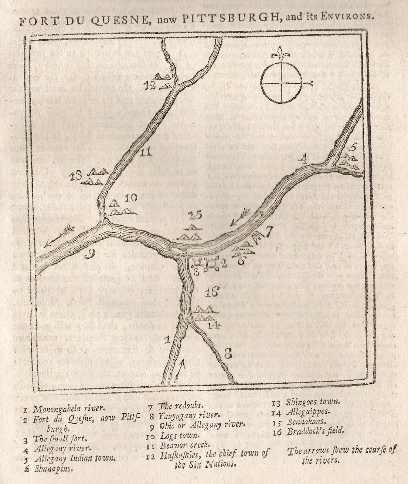
1759 FORT DU QUESNE, NOW PITTSBURGH, AND ITS ENVIRONS, from the January, 1759, issue of The Scots Magazine. This woodcut map has sometimes been called the "first map of Pittsburgh," since General Forbes' army seized control of the Forks of the Ohio and renamed it "Pittsburgh" in November, 1758. Apparently, within three months, a horseman got to Philadelphia and a ship from there reached London. The map identifies several sites as given by the number key at the bottom, and is accompanied by a short article with extracts from the letters of General Forbes. An untitled version appeared in the London Magazine of January 1759. It also appeared in Poor Roger, 1760, and in Father Abraham's Almanac, 1761. The small fort 3) on the map probably refers to Fort Prince George, constructed by a small force of Virginians under command of Captain William Trent in 1754, while 2) refers to the French Fort Duquesne. Another possibility is that the small fort is Mercer's Fort, constructed to house troops between the destruction of Fort Duquesne and the building of Fort Pitt. There were apparently no Indian villages right at the Forks, but several up and down the three rivers are named. The most substantial was Logstown, 10) on the map. Scale: 1 inch = 20 miles. Size: 4 x 4 inches. |
|
1761 PLAN OF FORT PITT and parts adjacent with both rivers. This is a manuscript map of the fort done by Bernard Ratzer circa 1761. It is reproduced in Hulbert(1907) with this date in four plates, all shown here, plate 2 , plate 3 , plate 4 . The complete plan is also shown in Stotz II-61. This plan had to be somewhat conjectural as the fort took several years to complete. |
|
1765 (John Rocque's Plans) Before he died in 1762 John Rocque prepared A Set of Plans and Forts in America. Reduced from Actual Surveys. This work provided the plans of all the frontier forts Rocque could lay hands on. The plans for Fort Bedford and Fort Pitt are illustrated in Schwartz (1994), Fort Ligonier was also included. The other forts were in New York and Canada. After Rocque's death, his wife Mary Ann published the work in 1765 in London. This work is on line at A Set of Plans and Forts in America, 1765 . In 1896 the state government published Report of the Commission to Locate the Sites of the Frontier Forts of Pennsylvania, a large and detailed two volume work with a description on line at frontierforts.htm . |
|
1772 PLAN OF FORT PITT OR PITTFBOURG, from Mante's History of the Late War, London 1772, reproduced in Winsor which is the image shown here; also reproduced in Egle. The Late War is the French and Indian War which ended circa 1763. This is the form of the fort begun in 1759 and the foundations and a surviving blockhouse can be seen today at Point State Park in Pittsburgh. Brown shows a sequence of plans dating from a manuscript sketch of Fort Duquesne in 1754 up to the 'Plan of the New Fort at Pittsburgh', November 1759, which is almost identical to this image. The history of the forts at Pittsburgh is complex. The first fort was a rudimentary one built by Virginians in 1754 and called Fort Prince George. It was destroyed the same year by the French who built Fort Duquesne. On December 1, 1758, the ruins of Fort Duquesne were officially renamed and from then on the Forks of the Ohio was called Pittsburgh. A temporary fort was built circa 1758-59 near the Monongahela River to house troops under the command of Colonel Hugh Mercer, and was called Mercer's Fort, see Brown, No. 35 and map 1758.9. This was followed by Fort Pitt, which took several years to build. It was abandoned by the British in 1772, taken over by Virginians in 1774 and renamed Fort Dunmore. It was again abandoned when the new Fort Fayette was constructed in 1791-92. This newer fort was used by General Anthony Wayne during the Indian wars in the Northwest Territory. |
|
1780 A MAP OF THE LAND ABT. RED STONE AND FORT PITT, GIVEN TO ME BY CAP. CRAWFD. The image is from the Library of Congress. This is an anonymous manuscript map with annotations by George Washington done circa 1780 per Sellers & van Ee #1332. The map itself was probably prepared earlier by "Cap. Crawfd," and may date circa 1758-71. It shows the river system around Pittsburgh located at upper right. "Crawfd" is undoubtedly Colonel William Crawford for whom Crawford County in Pennsylvania is named. He was a long time friend of Washington who survived the French & Indian War, Pontiac's Rebellion, and the Revolution, only to be burned at the stake in 1782 while leading an expedition into Ohio. Though the coverage is perhaps too broad to strictly call this a Pittsburgh map, it allows display of the fact that Washington slept there, though prior to when it was called Pittsburgh. Abraham Lincoln also slept there, staying at the Monongahela House on his way to Washington after the election of 1860. This hotel is long gone, but recently the bed Lincoln used was discovered stored in the attic of a county warehouse and given to the Historical Society of Western Pennsylvania. |
|
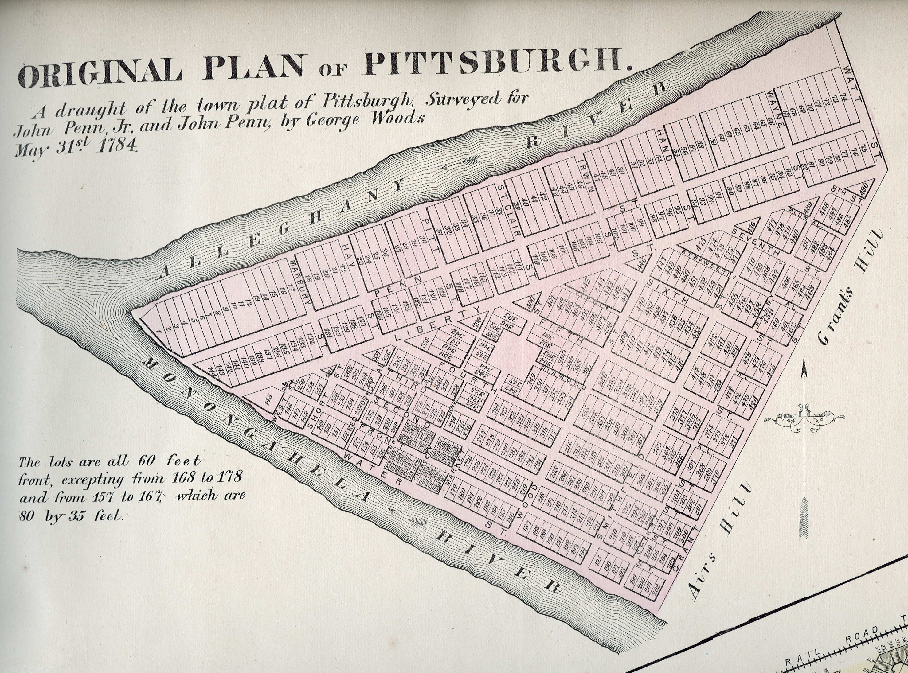
1784 (Pittsburgh) This 13.5 x 17 inch parchment manuscript map of downtown Pittsburgh sold at auction in 2005 for $55,000 to an apparently private owner. In 2009 it appeared in the listings of a New York City map dealer with an asking price of $150,000. It is the only surviving copy of the original Survey & Town Plan of Pittsburgh by George Woods, an agent for the Penns who owned the land. Three copies of the original document were known, but two were lost in the Great Fire of 1845. The third was held by Senator James Ross, who authenticated the map by deposition in an 1841 court case. A copy of the map (complete with Ross's authentification) is in the Allegheny County plat book, and subsequent real estate ownership in Pittsburgh's downtown is based on it. It shows the present downtown street arrangement with blocks laid out in individual building lots. In 1872, G. M. Hopkins published Atlas of the Cities of Pittsburgh, Allegheny, and the Adjoining Boroughs, which contained the printed copy shown here of the manuscript original. |
|
1787 PLAN OF THE LOTS LAID OUT AT PITTSBURG AND THE COAL HILL. Copied by John Hills, surveyor, Philadelphia 1787. This is a manuscript landownership map in the Library of Congress, Sellers & van Ee #1333. There is a similar manuscript map dated 1787 in the Darlington Memorial Library at the University of Pittsburgh. Coal Hill, to the right on the south bank of the "Monongahala", is now called Mount Washington, a name more suitable for upscale living. This image is from a poor modern reproduction. |
|
1795 FORT PITT IN 1795. This is a facsimile map from Report of the Commission to Locate the Sites of the Frontier Forts of Pennsylvania mentioned above, and shows the downtown layout set out by the 1784 manuscript map. Whether another manuscript map is the basis of this one is not known. It may be a conjecture from other maps of the period such as those above. |
|
1812 VIEW OF THE COUNTRY ROUND PITTSBURG, Drawn by J. Melish, J. Vallance F.S.A. Sculpt. This small map is from Travels in the United States of America, in the Years 1806 & 1807, and 1809, 1810 & 1811 by John Melish. Melish was from Scotland and visited America several times before settling here in 1811. He made notes on his visits and published Travels... in 1812 which included the maps that began his cartographic career.This map covers about 10 miles around Pittsburgh and is illustrated in Ristow, page 180. Blank verso. Scale: 1 inch = 0.3 miles. Size: 6.5 x 4 inches. |
|
1828 PITTSBURGH, page 101 from View of the United States, Historical, Geographical, and Statistical..., by William Darby, Philadelphia, published by H. S. Tanner 1828. This is a map of downtown with part of the north (Allegheny) and south (Birmingham) shores. There is a table on the left with letters locating points of interest within the city. The Pennsylvania Canal and the penitentiary are named. This map shows the first three river crossings built: the Monongahela River bridge in 1818, the Allegheny River bridge in 1819, and the Pennsylvania Canal aqueduct built close to the time of this map. The bridges were both covered wooden structures. Blank verso. Scale: 1 inch = 3000 feet. Size: 3.5 x 6 inches. |
|
1839 VIEW OF PITTSBURG. This view is from Modern Geography In Three Parts - PART I. A Grammar of Geography..., PART II. A Description of the Earth..., PART III. Geography Orthagraphy... . By Daniel Adams, A. M. Boston Published by Robert S. Davis. 1839. Seventeenth Edition, Revised. This little woodcut from a school geography book is one of the earliest views of Pittsburgh as a developing industrial center with burgeoning river traffic. The covered bridges over the rivers can be seen in the distance. This is one of the small number of views prior to the Great Fire of 1845, and illustrates why a such a fire was inevitable. Size: 2 x 4 inches. |
|
1848 VIEW OF PITTSBURGH, FROM THE NORTHWEST, an engraved print from A New and Popular Pictorial Description of the United States, Third Edition 1848, by Robert Sears. The Sears' book provided many Americans their first glimpse at well-known national landmarks, monuments, famous buildings, and natural wonders. All of the illustrations were finely drawn engravings printed on good paper. A virtually identical print had appeared in Day in 1843, so the same plate was used or copied. Thus, the view is actually prior to the Great Fire of 1845 which burned down many of the buildings shown. Size: 5 x 8 inches. |
|
1853 PITTSBURG. This map is the verso of page 115 from a publication by Phelps & Fanning; possibly Phelps' hundred cities and large towns of America: with railroad distances ... maps of ... cities, and other embellishments. New York, Phelps, Fanning & Co.; Cincinnati, A. Ranney, 1853; or Fanning's illustrated gazetteer of the United States ... with the population and other statistics from the census of 1850. Illustrated with seals and thirty-one state maps in countries, and fourteen maps of cities. New York, Phelps, Fanning & Co., 1853. The map may have appeared in both publications. The page with text has the date 1854. The Pennsylvania Canal is shown with its aqueduct across the Allegheny River. There is only one bridge, called the Suspension Bridge, over the Mon. A Pennsylvania R.R. Depot is shown at the Point with a dotted line, apparently tracks, coming down Liberty Avenue. So, this map catches Pittsburgh right at the transition from canal to railroad. No scale, but 1 inch ~ 5 blocks. Size: 9 x 5.5 inches. |
|
1854 PITTSBURG. A print from The Pictorial Sketch-book of Pennsylvania, by Eli Bowen, Eighth edition revised and greatly enlarged, W. White Smith, Publisher, No. 195 Chestnut Street, Philadelphia 1854. This book has about 500 pages and is really a travelers guide with an accompanying map of Pennsylvania. The section in the back with this sketch is titled Locomotive Sketches with Pen and Pencil from Philadelphia to Pittsburgh; and was also published separately. Bowen's book originally appeared around 1852 and so must have been very popular. The view is from Mt. Washington. There is one bridge over the Mon and several over the Allegheny; though none at the Point. |
|
1855 THE CITIES OF PITTSBURG AND ALLEGHENY...PENNSYLVANIA (AND) THE CITY OF CINCINNATI, OHIO, Plate No. 40 published by J. H. Colton & Co., New York. Although dated 1855, this map appeared in an 1859 edition of Colton's General Atlas, the same map appeared in several editions. Two city plans appear on the same page, only Pittsburgh is shown here colored by ward, showing streets, main buildings, railroads, stations etc. Scale: 1 inch = 0.375 miles. Size: 8 x 12.5 inches. |
|
1856 PITTSBURGH ENGRAVED FROM R.E. MCGOWIN'S MAP FOR GEORGE H. THURSTON 1856. An attractive map with a fancy grapevine border and small illustrations of buildings along the right edge; also an anonymous map with no printer or source identified. It shows the downtown with portions of the north (Allegheny City) and south side; insets of the neighborhoods of Lawrenceville and Manchester are along the left edge. There is a name 'Livingston, Roggen & Co.' printed at right, but whether this is the printer or an ad is not known. This map can be compared with the 1860 one below, also based on McGowin's map. George H. Thurston published Directory of Pittsburgh & vicinity for 1857-1858, which could be the source or a companion piece of this map. It is printed on poor paper and this copy has some condition problems; apparently originally folded for a book or report. Blank verso. No scale, 1 inch ~1 block. Size: 23.5 x 35 inches. |
|
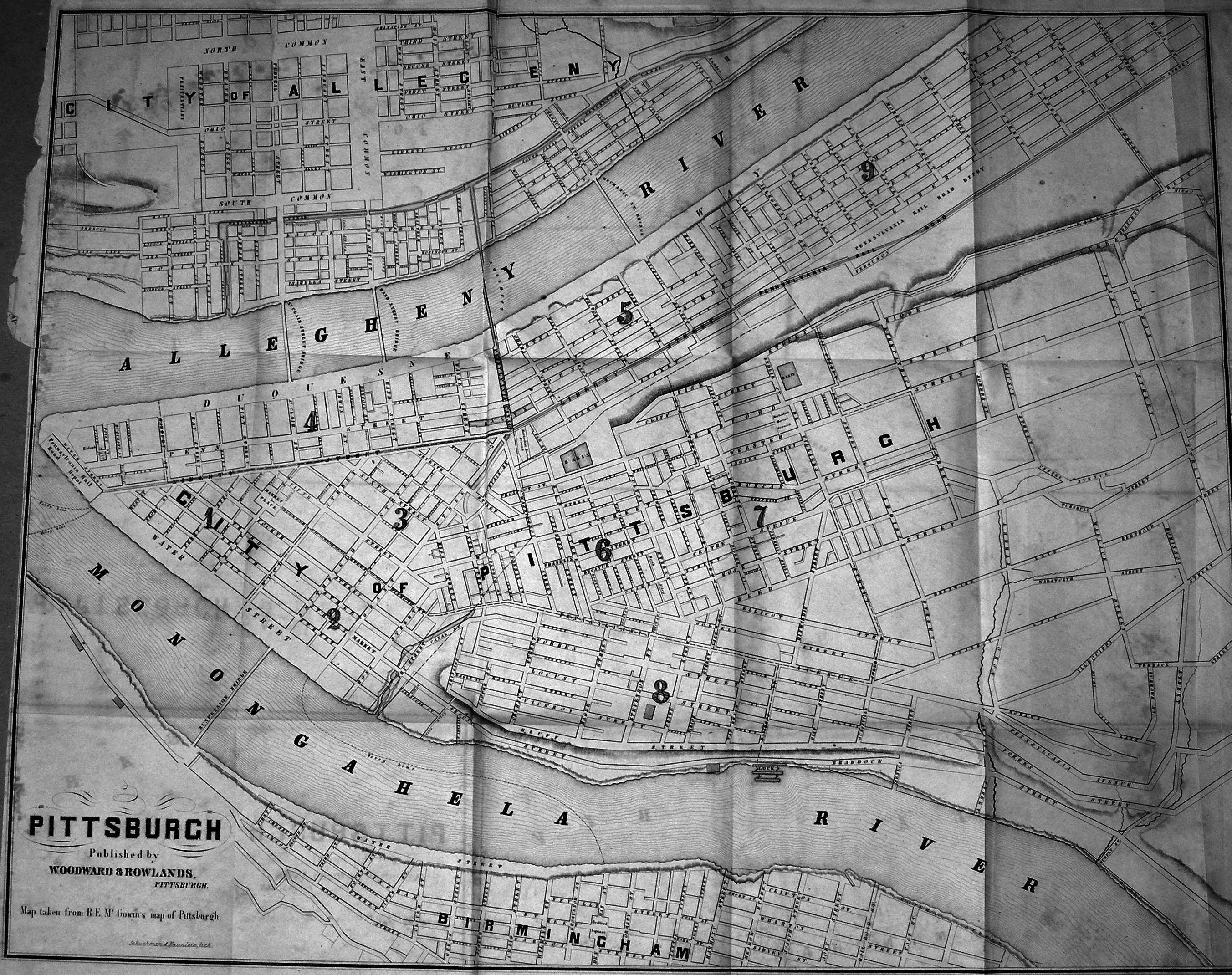
1860 PITTSBURGH. Published by Woodward & Rowlands, Pittsburgh. Map taken from R. E. McGowin's map of Pittsburgh. Schuchman & Haunlein, Lith. The source and exact dating of this map is not known; it is believed to date between 1855 and 1865. Only the downtown is shown. The canal enters town across the Allegheny and flows into the basin at the foot of Grant Street. The Pennsylvania Railroad comes down Liberty Avenue to a depot at the Point. There are no Point bridges, one bridge across the Mon called the Suspension Bridge. There are four structures across the Allegheny including the canal aqueduct. Blank verso. No scale, 1 inch ~ 1 block. Size: 21 x 25 inches. |
|
1867 WOODS' NEW MAP OF PITTSBURGH, ALLEGHENY AND SURROUNDINGS 1867. Engraved and Printed by A. Hani, Lithographer, St. Clair Street. Interesting old map of the city not seen before with the existing rail lines prominent. It is closely trimmed and appears to have been originally folded. Only the downtown area and close-in neighborhoods are shown. The lithographer appears to be Hani, an unusual name; and it is not known who "Woods" refers to, which is a common name in Pittsburgh. Augustus Hani & Co. was a lithography shop on St. Clair Street. On the map this street is adjacent to the Allegheny with a bridge of the same name, and has subsequently been renamed to Sixth Street today. The source of the map is also not known, but it must have been a local publication. This map somewhat resembles the 1855 Colton map shown above which may have been used as a model. Lithograph. Blank verso. Scale: 1 inch ~ 4 blocks. Size: 10 x 13.5 inches. |
|
1871 PITTSBURGH, ALLEGHENY & BIRMINGHAM 1871. drawn from nature, lithographed & published by Otto Krebs, Pittsburgh, Pa. Krebs, Otto, lithographer. This bird's-eye view of Pittsburgh shows the Point in the foreground, Birmingham (the South Side) is at the right and Allegheny (the North Side) is in the distance on the left. This image comes from the Library of Congress. There is a second Krebs lithograph of much the same scene dated 1874 by the Library of Congress, at whose website both can be see in greater detail. This later view shows a Point bridge extending across the Allegheny River to the North Side. |
|
1872 PITTSBURG, FROM SOLDIERS MONUMENT. A.R.W., W. Roberts Sc. This print of Pittsburgh from the south side heights was published in Picturesque America, or, The Land we live in : a delineation by pen and pencil of the mountains, rivers, lakes, forests, water-falls, shores, can~ons, valleys, cities, and other picturesque features of our country, with illustrations on steel and wood by eminent American artists; edited by William Cullen Bryant. New York : D. Appleton and Co. c1872-74. A.R.W. is believed to be Alfred R. Waud. The 1842 courthouse is prominent although the artist has twisted it to display the front. The suspension bridge across the Mon is shown. Size: 4.75 x 10 inches. |
|
1872 SOUTH PITTSBURG AND ALLEGHANY CITY. A.R.W. (Alfred R Waud). Two views looking south across the Mon at top, and north across the Allegheny at bottom; and taken from Picturesque America as the print above. The Mon shore has the appearance of being more industrialized than the Allegheny. An early Point bridge is seen in the bottom view. This journal, edited by William Cullen Bryant, was published from 1872 to 1874 and this print may date later than the one above. The verso has a view of the Ohio River from Marietta. Size; 10 x 12 inches. |
|
1872 (Pittsburgh) This untitled two page map appeared in the 1872 Atlas of Pennsylvania with Descriptions by H. F. Walling and O. W. Gray (see The 1872 Atlas ) . The map was provided by G. M. Hopkins and a similar copy appeared in the Hopkins' Atlas of the Cities of Pittsburgh, Allegheny, and the Adjoining Boroughs, 1872 (see Historic Pittsburgh ). The inset at top left shows the cutoff section along the Monongahela; the second inset shows a section along the Allegheny cut off at the top. When this map was made, the North Side (Allegheny) and South Side had not yet been incorporated into the city. |
|
1875 BIRDS-EYE VIEW OF PITTSBURGH . AS SEEN FROM TRAINS ON PAN HANDLE ROUTE. Lithographed by Otto Krebs, Pittsburgh. Entered according to Act of Congress in the year 1871... by Otto Krebs. This small 2.5 x 8 inch vignette appears on an atlas map showing routes of the Panhandle Railroad and otherwise dated to 1875 or a little later. Although dated 1871 along the bottom, this view is later than the Krebs one of similar date above as two bridges are now shown at the point. A large print of this is not listed in Stout or Reps, and Krebs may have altered an earlier view to produce this little one which is similar but not the same. |
|
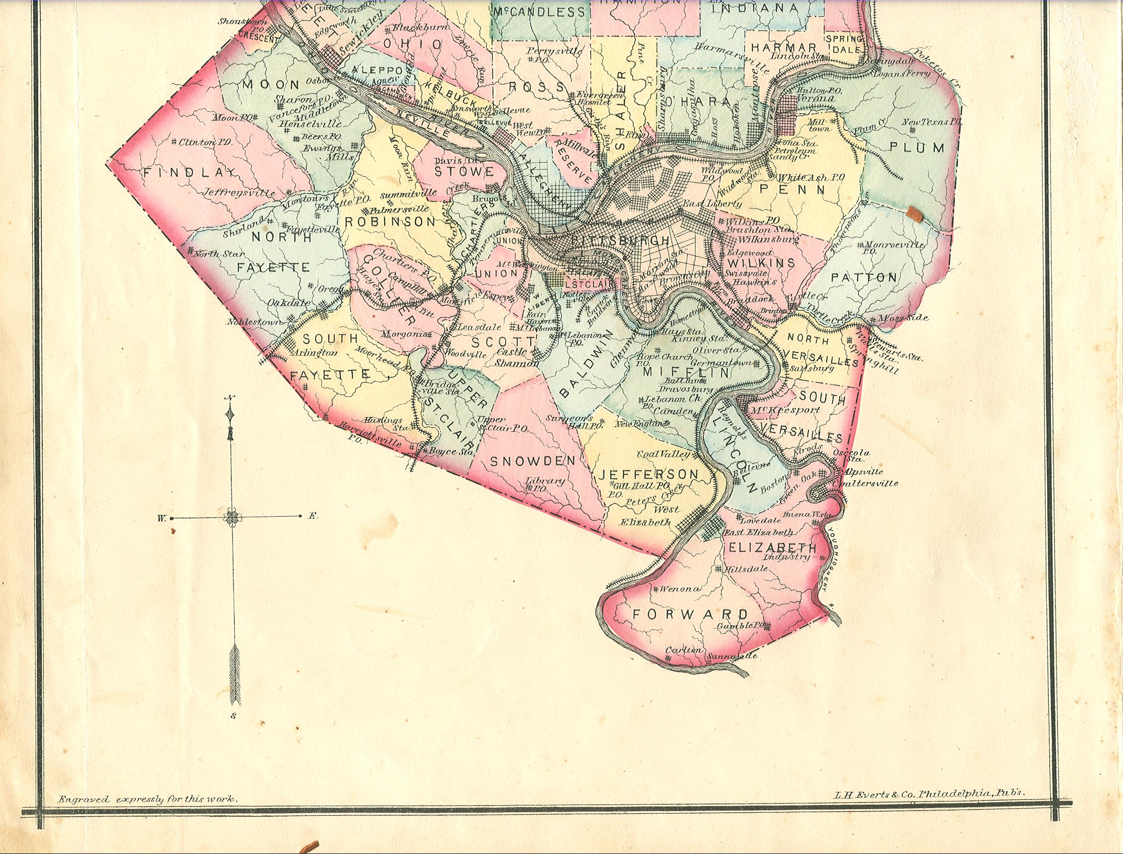
1876 OUTLINE PLAN OF ALLEGHENY COUNTY, published by L. H. Everts & Co., press of J. B. Lippincott & Co. Philadelphia. This is Plate II from Everts' A History of Allegheny County 1876. The north has been cropped in this view to center Pittsburgh, which is the county seat. This map is interesting for the variety of street grids shown as the city expands outward. Blank verso. Scale: 1 inch = 4 miles. Size: 14 x 11.5 inches. |
|
1877 BIRDSEYE VIEW OF PITTSBURGH. This print is page 377 and from an unknown source, though it may come from Pictorial History of the U.S. 1876. The view is from Mt. Washington (the old Coal Hill). The 1842 courthouse is shown so the print dates earlier than 1882 when this courthouse was destroyed by fire. Steamboats are pulled up on the Mon shore which is lined with warehouses and smoke is coming from many stacks. Size: 5 x 7.5 inches. |
|
1877 VIEW OF PITTSBURGH, LOOKING UP THE OHIO. This print is page 314 from Egle. The viewpoint is similar to the 1848 print shown above, and Pittsburgh looks just a tad more smoky. |
|
1880 VIEW OF PITTSBURGH. An illustration (apparently by one H Delorme) on page 865 from Volume LXII Number 367 of the December 1880 issue of Harper's New Monthly Magazine. The image depicts a panoramic view of Pittsburgh from Mt. Washington. Bridges are shown at the Point; the old courthouse which burned in 1882 appears. On the verso is a night time scene of laborers with mills in the background. Size; 3.5 x 8 inches. |
|
1889 PITTSBURGH IN 1889. This print was actually made in 1939 and appears on pages 112-113 of a Fortune Magazine from that year. The pages were an ad from the Union Trust Company celebrating its 50th anniversary; the accompanying 1939 print is shown below. The cartographer is identified as Ezra C. Styles. There are small inset maps at the corners. The 1888 Richardson courthouse is shown and there is an Exhibition Hall at the Point which apparently stood until 1916. The number of bridges across the rivers has grown. Size: 11 x 14 inches. |
|
1892 REED'S MAP OF PITTSBURGH AND ALLEGHENY CITY, published by Baird Reed, Pittsburgh, Pa. Copyright 1891. This black & white map has a ad on the top face, with an 1892 date, for J. R. Weldin & Co. And there is another ad on the bottom for John S. Roberts Wall Paper. The map is attached to a brown paper cover with The Pittsburg Photo-Engraving Co.... Commercial Engraving Superior Printing Telephone 1459. The expansion of the city away from the Point area is now obvious. Size: 26 x 21 inches. |
|
1892 PITTSBURG, PENNSYLVANIA, FROM GRAND VIEW AVENUE - Drawn by Charles Graham. Harper's Weekly, New York, Saturday, February 27, 1892. Vol. xxxvi no. 1836. Harper & Brothers. This magnificent city view with an accompanying article appeared on pp. 202-205. It is printed in relief and is likely a stereotype from a very large wood engraving. Grandview Avenue is on Mount Washington above the city and can be seen on the 1892 map above. Size: 16 x 22 inches. |
|
1895 PITTSBURG AND ALLEGHENY. The origin of this map is uncertain but it is believed to be from Johnson's universal cyclopedia; a new edition, prepared by a corps of thirty-six editors, assisted by eminent European and American specialists, under the direction of Charls Kendall Adams. New York, D. Appleton, A. J. Johnson, 8 Volumes 1893-97. This is an attractive map and identifies topographic features, roads, churches, hotels, theatres, public buildings, colleges, and railroads. The north side is still the city of Allegheny and Pittsburgh includes only a portion of the south side; Beltzhoover, Knoxville, and Lower St. Clair are shown as still independent. Blank verso. Scale: 1 inch = 7/8 mile. Size: 11 x 13.25 inches. |
|
1896 MAIN PORTION OF PITTSBURG AND ALLEGHENY, copyright 1896 by Rand McNally & Co. This map is thought to have been published in McNally's Pittsburg Dispatch Atlas; the only listing found for this atlas is dated 1904. This view shows a detailed downtown street map, while the verso is a township map showing the vicinity around Pittsburgh. |
|
1899 PITTSBURG AND ALLEGHENY, Wagner & Debes' Geogl. Estabt. Leipzig; from The United States, with an excursion into Mexico, published by Karl Baedeker, 2d rev. ed. Leipsig; New York, C. Scribner's Sons 1899. The first edition of this travel guide from the famous German publisher was in 1893 and it was printed several times with subsequent editions. Note the dotted line indicating a railroad tunnel between the "Union Sta." and "R.R. Bridge;" this tunnel was incorporated into the present day downtown subway. The map also shows the location of several inclines, only two of which remain today. Scale:1 inch = 2000 feet; Size: 6 x 8.5 inches. |
|
1900 VIEW OF PITTSBURGH, PENNSYLVANIA. The exact dating of this anonymous photogravure is not known; it is believed to come from an 1890's photo book but the text below the map ("One hundred and fifty years ago there stood on the delta formed by the Alleghany and Monongahela rivers the old French fort Du Quesne.") could date it to 1905. The picture was taken from the western edge of Mt. Washington and shows the city in its industrial prime. |
|
1902 PITTSBURGH, PENNSYLVANIA 1902. Drawn by T. M. Fowler. Published Morrisville, Pa., T. M. Fowler & James B. Moyer. Fowler did views of almost 300 towns in Pennsylvania and this is his view of Pittsburgh. The image comes from the Library of Congress website where it can be seen in greater detail. |
|
1905 (Pittsburgh) An undated and untitled map of the Pittsburgh region that has been sectioned and pasted on linen for easy folding. It looks like a circa 1900 US Geological Survey map; these were first issued circa 1900-1905, so that dating is used here. About 10 miles around the Point are shown. Folding geological maps like this were used by early aviators and became the first aviation maps. They were used by pilots prior to World War II. Whether this one saw that use is not known. Pittsburgh had several airfields: Mayer Field in Bridgeville opened in 1919 by Casper P. Mayer and now gone; Rodgers Field also now gone, near the Fox Chapel Golf Club, was named for Calbraith Perry Rodgers who was the first to cross the United States by airplane in 1911 ; Bettis Field had paved runways and is now an industrial site; Allegheny County Airport in West Mifflin is still in business for general aviation; Pittsburgh International in Moon Township has been the main airport since around 1950. None of these fields are shown on the map. Size: 18 x 19 inches. |
|
1906 RAINEY'S MAP OF MONONGAHELA RIVER COAL REGION FROM PITTSBURG TO WEST VIRGINIA LINE, copyright 1896 by C. T. Rainey, Revised Edition - Jan. 1906, copyright assigned to N. P. Hyndman, Pittsburg, Pa. Andrew B. Graham Co. Lithographers, Washington, D.C. This map shows the region from about 8 miles west of Pittsburgh east to the county line and then south towards West Virginia. It is something of a stretch to include this map but it illustrates what built Pittsburgh industry. Mon Valley coal field ownership is shown by color with around 20 companies identified. Surface owners (who had no rights in Pennsylvania as the legislature was controlled by corporations, and who still don't) are also identified in small print. There are still large operating coal mines south of the city in Washington, Fayette, and Greene counties. The map is printed on treated paper backed with linen and folds into a black cover. Hyndman was a Pittsburgh map seller located at 7 Wood Street. This image shows the top with Pittsburgh in greater detail. Rainey also made a similar farm ownership map of Greene County. Scale: 1 inch = 1.25 miles. Size: 44 x 24 inches. |
|
1906 MAP OF PITTSBURGH, ALLEGHENY AND ENVIRONS, from Official Records, Original Plats and Actual Survey, 1906. Published R. L. Polk and R. L. Dudley. This large foldout map shows the street layout, rail and street car lines, ward boundaries, etc. It extends west to McKees Rocks, east to Wilkinsburg and includes the south side. There is a street gazetteer on the verso. It folds into the plain brown cover pictured, sold by H. A. Schafer News Co. Inc., 307-9-11 Third Ave., Pittsburg, Pa. Size: 26 x 40 inches. |
|
1906 PITTSBURGH PA. AND ENVIRONS, page 743 from The Automobile Official AAA 1906 Blue Book, A Touring Guide to the best and most popular routes in the Eastern and Northern states, with a Canadian section. Published by the Class Journal Company. Here is the city at the dawn of time, or at the dawn of the automobile age, the same thing in the US. The map shows what were considered the main through routes of the time. The 782 page book gives detailed driving directions for hundreds of numbered routes, several through Pittsburgh. This one is the way to Gettysburg. The directions are interspersed with maps and ads as shown here. |
|
1907 This is a view of the mid-downtown area from the South Side. The gracefully curved Smithfield Street bridge is to the right. The image is from the Library of Congress. The panoramic photo craze ran from around the turn of the century to about 1930. The LOC has a fairly extensive collection much of which is digitized and available at their American Memory website. |
|
1908 This is a panoramic view of the entire downtown from Mt. Washington. Again the Smithfield Street bridge is to the right; the huge clunky railroad bridge to the left is long gone. Almost all old (and new) views and photos of Pittsburgh are from Mt. Washington, for obvious reasons if you have ever visited the city. The image is from the Library of Congress. |
|
1908 PITTSBVRGH IN YE OLDEN TIME, A PICTORIAL AND CHRONOLOGICAL REVIEW OF THE FIRST CENTURY OF ITS HISTORY. Published by Charles C. Benton 1908. This is a 32 page souvenir booklet from the 1908 Pittsburgh sesqui-centennial (that's 150 years) presented with the compliments of the Union Safe Deposit Company. It is so appropo to the 2008 250th anniversary (the sesqui-bicentennial?) that it is reproduced here in full. There are three maps plus numerous views and photos, some shown above. |
|
1909 This view of the Point area is from further west along Mt. Washington. The superimposed vignette to the right with the man standing on a terrace has nothing to do with reality and is apparently intended to be satirical. The image is from the Library of Congress. |
|
1910 VULCAN'S CAPITOL FIVE ETCHINGS OF PITTSBURG BY JOSEPH PENNELL, from the July 1910 edition of the Century Magazine. There is no text, just the 5 illustrations: 1) GENERAL VIEW OF HOMESTEAD, 2) WHERE THE ALLEGHENY AND THE MONONGAHELA JOIN TO FORM THE OHIO, 3) FORT POINT (?) AND THE SKYSCRAPERS, 4) THE EDGAR THOMSON STEEL WORKS, 5) ON THE WAY TO BESSEMER. All show a smoky place, only the second print is shown here with the city almost obscured by smoke. Pennell, from Philadelphia, was a turn-of-the-century etcher, lithographer, and writer who was a major book illustrator of his day. |
|
1911 PITTSBURGH MAIN THOROUGHFARES AND THE DOWN TOWN DISTRICT 1910, IMPROVEMENTS NECESSARY TO MEET THE CITY'S PRESENT AND FUTURE NEEDS. A report by Frederick Law Olmsted, prepared under the direction of the Committee on City Planning. Publication No. 8, February, 1911. This booklet has the following maps: 1) LOCATION MAP FOR 80 IMPROVEMENTS IN THE OUTLYING THOROUGHFARES, 20 x 26 inches, a marked up US Geological Survey map. 2) GENERAL MAP OF THE PITTSBURGH DISTRICT, 10 x 13.5 inches, and which is stippled to show land use. 3) GENERAL PLAN OF THE DOWN TOWN DISTRICT, 10 x 13.5 inches, with suggested parks marked in green. The last 2 maps are illustrated here. Olmsted was a famous landscaper whose best known work is New York's Central Park and the Biltmore House grounds. Needless to say, this being Pittsburgh, little to none of this planning was ever implemented. |
|
1912 (Pittsburgh) This is an untitled manuscript map of the South Side stamped 'EXHIBIT COURT OF COMMON PLEAS ALLEGHENY COUNTY, MARCH 27 1912, EDWIN L. ALLEN OFFICIAL STENOGRAPHER,' and apparently used for a court case. The scale is roughly 1 inch = 50 feet, so it shows about a half mile of the South Side shoreline from Becks Run downstream. Although drawn to be viewed in this orientation, it is confusing. South is to the top and west, or downstream, is to the left, the Mon is at the bottom. Many John Miller buildings are named, stables, sheds, and a school house. The right-of-way of the Pittsburgh, McKeesport and Youghiogheny Railroad is noted but not built. The map is hand colored, soiled, and being rolled for so many years, no longer flat. Only a small section at the start of the map is shown here. Size: 19 x 70 inches. |
|
1915 PITTSBURGH, a Rand McNally Vest Pocket Map showing streets, transportation lines, parks, public buildings, etc. The map itself is titled RAND MCNALLY NEW COMMERCIAL ATLAS MAP OF PITTSBURGH, and not quite all of it is shown in this view. The verso has a gazetteer of streets and buildings. The map folds into a 6.25 x 4 inch paper cover and is undated but believed to date circa 1915-20. The old Point bridges are shown and Allegheny City is part of Pittsburgh. Size: 20 x 26 inches. |
|
1918 ONE WAY STREETS AND PARKING REGULATIONS PITTSBURGH, PA. Ah, downtown parking, a problem even in 1918. This is an undated Gulf road map of Pittsburgh with no printer identified and in the form of a mailer. The text has "After Sept. 1, 1919", so the map dates either 1918 or early 1919. The cover is similar to other Gulf 1918 road maps, so that dating is used here. Five Gulf stations are listed for Pittsburgh and two for Philadelphia. Today parking is not all that tight downtown because it is so expensive. For other Gulf road maps of Pittsburgh from this era, see the article The Early Gulf Road Maps of Pennsylvania . Size: 11 x 9 inches. |
|
1920 This is a panoramic view of downtown from Mt. Washington similar to those shown above. Again the Smithfield Street bridge is to the right and the railroad bridge at the center is now gone. The image is from the Library of Congress. |
|
1919 LEWIS' PITTSBURGH STREET & TROLLY GUIDE, pocket directory... containing a map of the business section, a ward and district map , and a map of the interurban electric lines. H. A. Schafer News Co. Distributors, 307-9-11 Third Ave. Pittsburgh. Copyright 1919 by J. L. Lewis, and probably not that J. L. Lewis of coal union fame. A 144 page booklet with the maps listed, descriptions of Pittsburgh sites, a gazetteer of streets and trolly lines, and some other stuff. Size: 6.25 x 3.25 inches, with the maps somewhat larger. |
|
1923 WAGNER'S COMPLETE INDEXED MAP OF PITTSBURGH AND ADJOINING BOROS, The A. C. Wagner Co., Publishers, PO Box 1055 Pittsburgh, Main Plant Cincinnati. This is an undated map but it has a Gulf ad on the back that appeared from around 1919 to 1923, so that dating is used here. The map folds into the 7 x 4 inch paper cover shown containing pages with a street index which is continued onto the map. Trolley and rail lines are shown. Blank verso. Scale: 1 inch = 0.45 miles. Size: 24 x 38 inches. |
|
1923 AUTOMOBILE TOURISTS' MAP THROUGH PITTSBURGH, PENNA. Copyright 1923 Chamber of Commerce of Pittsburgh. This is a strip map centered on Pittsburgh and extending from New York to Chicago and St. Louis. It contains this 7.5 X 6 inch map showing the route of the Lincoln Highway (now US 30) through town along with a connection south to the National Road (now US 40). Today, instead of traveling along the north shore of the Ohio River, US 30 goes south across the Fort Pitt bridge and through the Fort Pitt tunnel. |
|
1926 LIPPINCOTT AND NCNEIL'S MAP OF GREATER PITTSBURGH, Lippincott and McNeil, Engrs, 237 4th Avenue, Pittsburgh. Copyright 1926 H. C. Lippincott. This street map, despite the title, shows only the immediate city. Street car lines are in red and there is a street index around the edge. This is a later version of a map first put out around 1912. Folds into a 7 x 4 inch yellow paper cover to which it is attached. Blank verso. Scale: 1 inch = 2000 feet. Size: 36 x 48 inches. |
|
1926 PITTSBURGH THE CITY OF POWER Guide to Points of Interest. This brochure, issued by the Chamber of Commerce, has 11 pages of text plus a 5 x 7 inch map and several photos. The map has an index to points of interest. The date of 1926 appears in the text in reference to the Carnegie International Art Exhibit; but it may have been issued a year or two later. Needless to say, city of power is no longer used as a catch phrase, at least in reference to industry. |
|
1931 JUST AROUND THE CORNER, Amoco - Rand McNally. Although Gulf published city maps from its earliest days (see 1918 above), the other oil companies were slower to put out such maps. This tiny 6 x 7 inch map is an early one from Amoco. It was intended to show the location of their gas stations. |
|
1939 PITTSBURGH IN 1939. This print appears on pages 112-113 of a Fortune Magazine from that year. The pages were an ad from the Union Trust Company celebrating its 50th anniversary; the accompanying 1889 print is shown above. The cartographer is identified as Ezra C. Styles. There are small inset maps at the corners. Skyscrapers are starting to poke up. Size: 11 x 14 inches. |
|
1941 CRAM'S OFFICIAL INDEXED STREET MAP OF PITTSBURGH, MCKEESPORT, WILKINSBURG, AMBRIDGE, DUQUESNE AND 68 OTHER MUNICIPALITIES IN THE PITTSBURGH AREA. The George F. Cram Co. Inc., Indianapolis. This map has the code LR241, and so is dated February, 1941. It is folded like a road map with a colorful cover. Besides the main map , not all of which is shown, it has this image of downtown. Size: 34 x 24 inches. |
|
1941 SOUVENIR OF PITTSBURGH, PENNA. Copyright 1941 by Minsky Bros. & Co., Pittsburgh, Pa. A 9 sheet folded postcard with a map of downtown on the inside cover and 18 color views . Folded postcards can probably still be found today at tourist stops, but their craze ran from about 1920 to 1950. The biggest publisher was Curt Teich & Co. of Chicago, whose cards date from the early 20s. Minsky licensed the process and his cards began to appear in the late 30s. Size folded: 4 x 6 inches. |
|
1950 THE PREMIER STREET MAP OF PITTSBURGH, published by Geographia Map Co. Inc. 145 W. 57th St., New York. Produced under the direction of Alexander Gross, F.R.G.S. This is an undated foldout map probably put out in the late 40s, so dated circa 1950 here. It is an attractive large map with a street gazetteer on the verso that folds into the 9.5 x 4.5 inch purple cover pictured. Scale: 1 inch = 1600 feet. Size: 34 x 45 inches. |
|
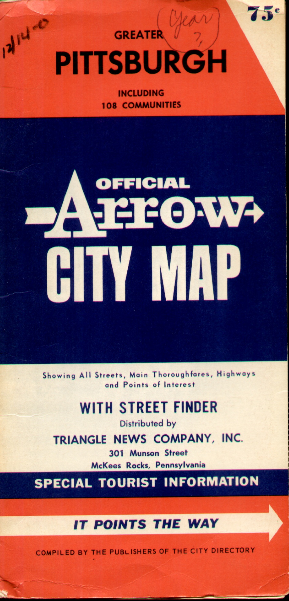
1955 GREATER PITTSBURGH INCLUDING 108 COMMUNITIES, Official Arrow City Map. This undated map is copyright by R. L. Polk, Boston; and distributed by Triangle News Company, Inc. McKees Rocks. The old Point bridges are shown along with the new Fort Pitt Bridge labeled I79, no Duquesne Bridge across the Allegheny, so the map is circa 1955-60. The current route over the bridge is I376. There is a street gazetteer on the verso. Size: 28 x 42 inches. |
|
1956 MONONGAHELA RIVER NAVIGATION CHARTS, issued by the Corps of Engineers US Army, the District Engineer, Pittsburgh District, 925 New Federal Building, Pittsburgh 19 Pa. This booklet has an index map and 21 river charts showing navigation from the Point to just past Fairmont, WV. This chart shows the point area. Here is a later map showing the Point from OHIO RIVER NAVIGATION CHARTS, 1978. |
|
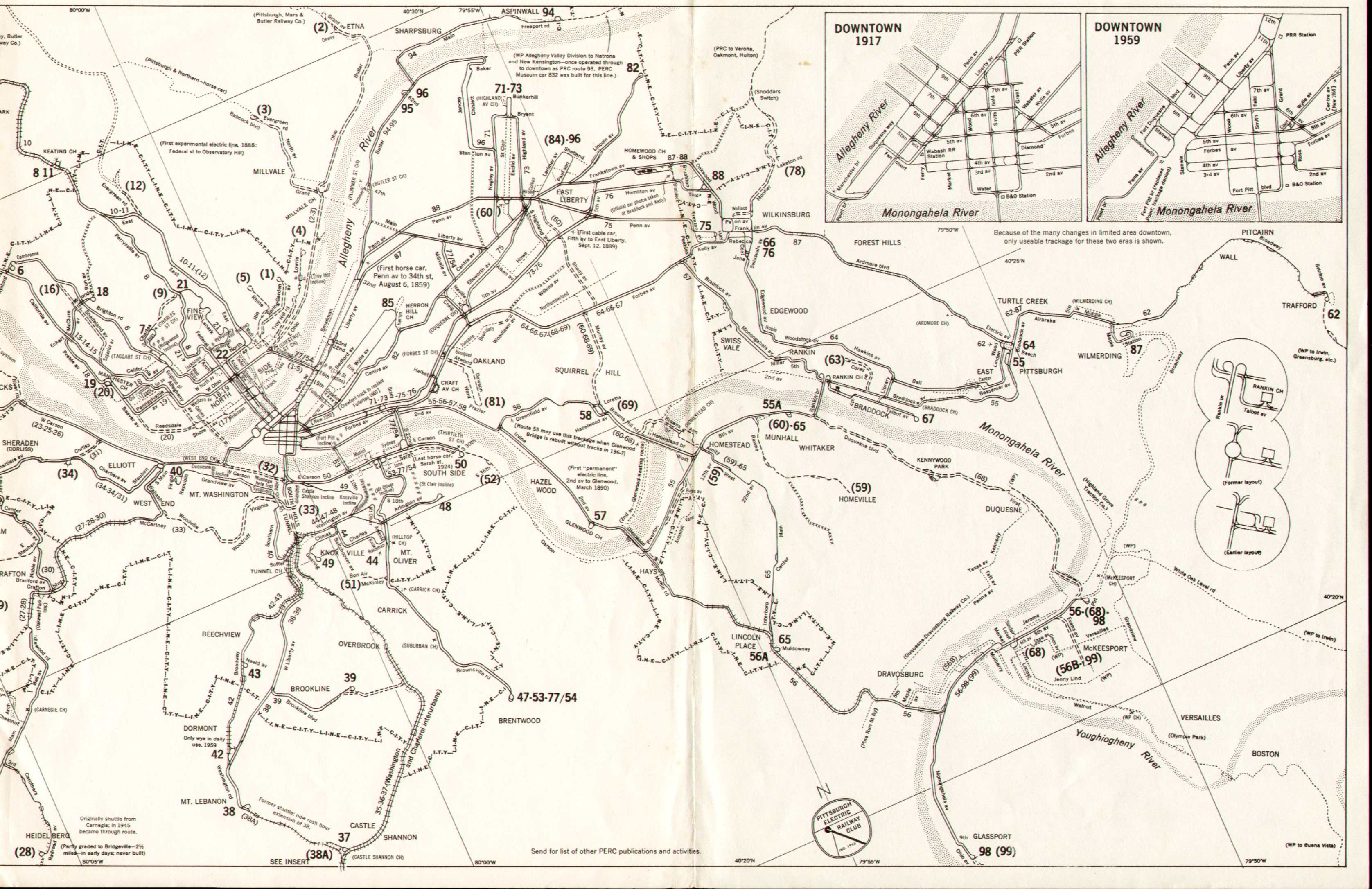
1959 PITTSBURGH PA. AND VICINITY STREET AND INTERURBAN RAILWAY TRACKAGE 1859-1959, Published by Pittsburgh Electric Railway Club, Inc., based on various maps of 1869 to 1955, and researched by PERC members. Compiled and drawn by M. F. McGrew. This map describes itself, a history on one sheet of city trolley lines. About two thirds of the map is shown here, a section to the west is not seen. Blank verso. Scale: 1 inch = 1 mile. Size: 11 x 25 inches. |
|
1960 THIS IS THE NEW PITTSBURGH. A red cover brochure put out by the Pittsburgh Convention & Visitors Bureau. It unfolds to a map of downtown with a gazetteer of buildings, photos, and text. Undated, but circa early 60s, Forbes Field is still there. Size unfolded: 16 x 18 inches. |
|
1960 MAPCO MAP OF GREATER PITTSBURGH PENNSYLVANIA, Copyright Map Corporation of America, Boston, Mass. This undated map is circa 1960 because Fort Pitt Bridge and tunnel are shown as under construction. The verso contains street names with location index. It folds into a 9 x 4 inch yellow paper cover saying Distributed by Triangle News Co., McKees Rocks. Size: 31 x 42 inches. |
|
1966 (Pittsburgh) A set of four maps from the book Urban Atlas: 20 American Cities: A Communication Study Notating Selected Urban Data at a Scale of 1:48,000, by Joseph R. Passanneau & Richard Saul Wurman. 1966. M.I.T. Press. The maps are: 1) a city street map with verso of land use, 2) a personal income map , 3) a population density map, 4) a combined income and density map . Only the two maps indicated are shown here. In the combined map, blue is money and red is population. About two thirds of each map is shown in the image. This use of dots to show demographics seems awkward, and the maps are plastic coated for some reason. Size: 18 x 18 inches. |
|
1980 PITTSBURGH, GMC/80 City Character Print, Produced and Published by Archar Inc., Mississauga, Ontario, Canada. A large and colorful poster with a cartoon bird's eye view of the city. The Point area is shown with some extension up the rivers. The publisher produced these for a number of cities. Blank verso, not to scale. Size: 29 x 39 inches. |
|
1985 (Pittsburgh) An untitled and undated Landsat photograph from space of Pittsburgh. It was published by the US government on heavy photographic paper circa mid 80s. The coverage includes the area north and west of the Point. The shiny surface makes these landsat maps hard to photograph clearly. Size: 23 x 29 inches. |
|
1998 PITTSBURGH FROM SPACE. EOSAT 1998 M-SAT Corp., Rockville, Md. Another Landsat photograph, this one from a private company. Coverage here extends west and south of the city. Size: 20 x 28 inches. |
|
2006 (Pittsburgh) An untitled and figurative advertising map put out by the Pittsburgh Roars Committee and published by Pittsburgh Magazine, an arm of the local public TV station WQED. Only the section around the point is shown here. "Pittsburgh Roars" was a city wide ad campaign originating with an art exhibit at the Carnegie Museum of Art called "Fierce Friends: Artists and Animals 1750-1900." Other local arts groups tried to work animal themes into whatever they were doing at the time. And, of course, Pittsburgh Zoo participated. The idea was to entice tourists into the local attractions (and hotels and restaurants). The map is out of proportion and some of the things on it are conjectual; the African-American center, for example, is only now (2008) starting construction. Size: 16 x 21 inches. |
| |
Almost Now Try one of these: http://www.yahoo.com/ , http://maps.google.com/ , http://www.mapquest.com/ , for a current street or aerial map like the little one here. |
| Home Page | 16th Century Maps | 17th Century Maps | 18th Century Maps | 19th Century Maps | 20th Century Maps | References |