


| WELCOME | 1770 to 1774 Pennsylvania Maps | WELCOME |
The United States of America was created in this decade. Like the French & Indian War, the Revolutionary War resulted in a number of manuscript maps of marches and battles from 1776 on. These have been collected in an atlas by Marshall & Peckham and several show areas of Pennsylvania covering British General Sir William Howe's invasion of the state and seizure of Philadelphia in 1777. William Faden engraved and published a number of Revolutionary War maps shortly after the events depicted on them occurred. Many of these are in Faden's North American Atlas and reproduced in Nebenzahl & Higginbotham. The two books by Guthorn constitute a cartobibliography of Revolutionary War maps.
The first map with the name United States was one (there is some question which one) of the late 1770's French maps with 'Etats Unis' in the title. Phillips, page 859, says the map CARTE DU THEATRE DE LA GUERRE ACTUEL Entre les Anglais et les Treize Colonies Unies de l'Amerique Septentrionale dressee par J. B. Eliot Ingenieurs des Etats Unis 1778..., is the first map with 'Etats Unis'. But only the northern states are shown on it and 'Etats Unis' is not actually in the title which refers to the thirteen colonies, 'Treize Colonies'. A 1778 reissue of a previous de Vaugondy map, CARTE DU CANADA ET DES ETATS-UNIS DE L'AMERIQUE SEPTENTRIONALE..., has Etats-Unis in the title and would seem to have a better claim. For more see MapForum.Com , Issue 1, where a list of United States maps published between 1776 and 1800 is given and this topic is discussed; also see chapter 4 in Ristow.
Bedford County with the county seat at (Fort) Bedford was created in 1771. Northumberland County with the seat at Sunbury was created in 1772, followed by Westmoreland County in 1773 with the seat at Hannastown, later moved to Greensburg.
|
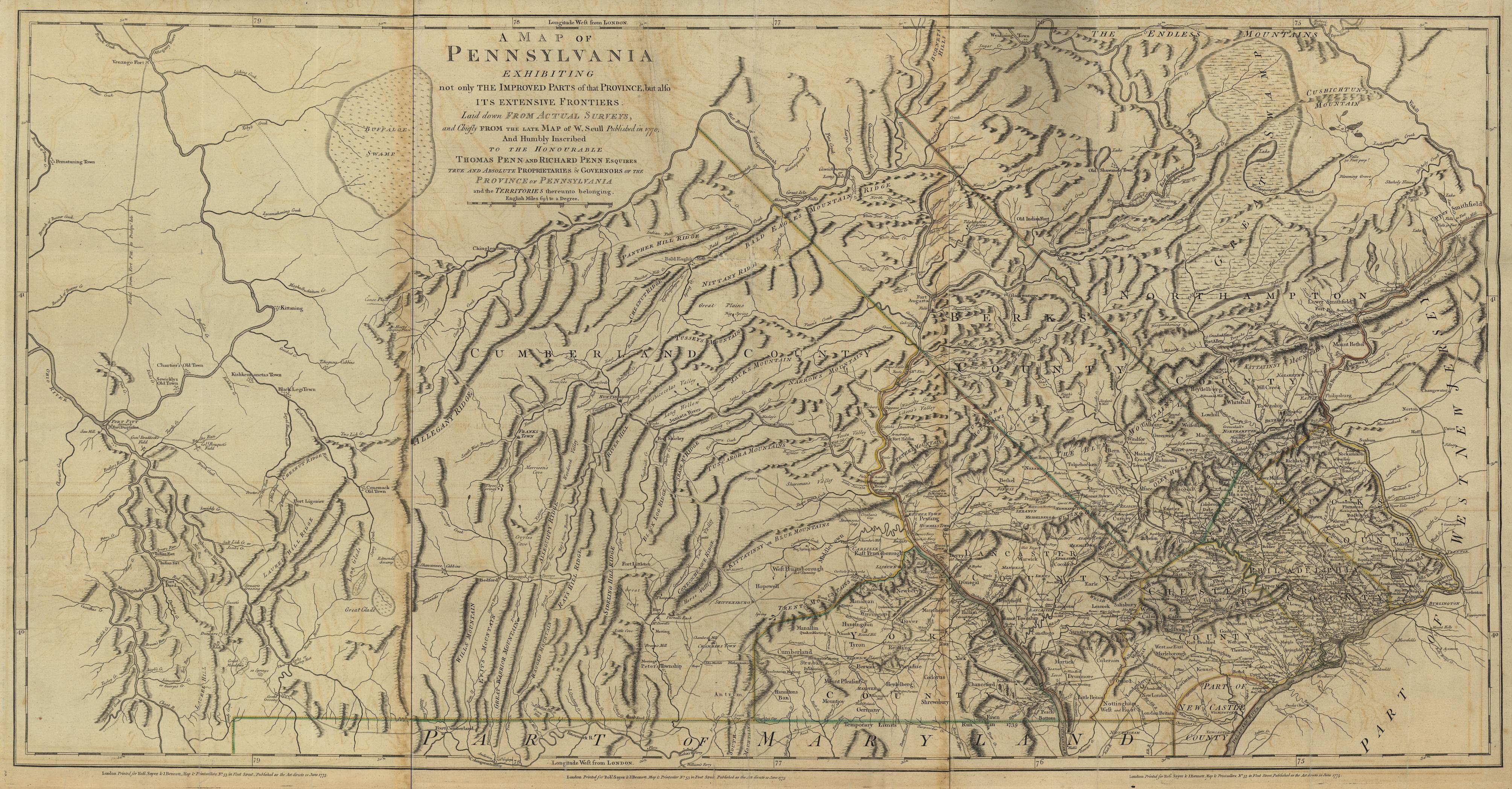
1770.1 To the Honorable Thomas Penn and Richard Penn, Esquires, true and absolute Proprietaries and Governors of the Province of Pennsylvania and the Territories thereunto belonging and to the Honorable John Penn, Esquire, Lieutenant-Governor of the same, THIS MAP. OF THE PROVINCE OF PENNSYLVANIA. Is humbly dedicated, by their most obedient humble servt: W. Scull. Henry Dawkins, sculpt. Philadelphia, Printed by James Nevil, for the author, April 4st, 1770. The map is reproduced in Fite & Freeman#57, Ristow, and Schwartz & Ehrenberg, and elsewhere. William used information about western Pennsylvania gained during the French and Indian War to update his grandfather Nicholas Scull's 1759 map. Thus, the locations of Braddock's defeat and Bouquet's victory are shown near Pittsburgh. This map shows considerably more of the state than the 1759 map, but not all. It extends north only to about 41d 45m and west only to the Beaver River. The southern boundary was fixed by the 1768 Mason-Dixon survey only as far as the Maryland boundary extends. The western boundary with Virginia was left undefined. The most common versions of this map are the 1775 Sayer & Bennett which appeared in Faden's North American Atlas of 1777, shown here from the Library of Congress, and the 1778 French copy by Le Rouge. The Le Rouge version can be seen at the Darlington Library, where it is dated circa 1777. Sellers & van Ee #1295, Phillips page 674, Wheat & Brun #425. |
|
1770.2 A CORRECT MAP OF NORTH AMERICA. Paas sc Holborn. Despite the title, this map shows only the Mid-Atlantic region and is a copy of the de Vaugondy map 1755.20. This undated map was seen at auction dated 1770 and that date is used here. McCorkle (#800.2) dates it to 1800, however that may be a later use of the plate as the map would be way out of date by then and it is hard to imagine it being re-engraved. |
| 1770.3 PLAN OF FRANKLIN TOWNSHIP containing 31,723 a[cres], 1 rod 34 p[erches] of land divided among the Proprietors into twelve lots; viz, the River-lots containing 1,860 a[cres] . . . each, and the back or rear lots 3,426 a[cres] each. Copied from Robert Lettis Hooper, Jr., plan dated in November 1770. Scale: 1 inch =100 chains. This manuscript map was found listed as #16 in the map archives of the American Philosophical Society in the papers of William Franklin dated circa 1770. | |
| 1770.4 (Pennsylvania) An anonymous and undated manuscript map in the collections of the Historical Society of Pennsylvania dated 177_. The catalog title is EAST, WEST, AND SOUTH BOUNDARIES OF PENNSYLVANIA. See Docktor #25_A5, #27_A5. | |
| 1770.5 (Western Pennsylvania) There are two untitled and undated manuscript maps in the collections of the Historical Society of Pennsylvania by John Erving and Alexander Stuart concerned with establishing the western boundaries, and dated 177_. See Docktor #27_E5, #27_E6. | |
| 1770.6 (Berks County) There are two anonymous and undated manuscript maps at the Historical Society of Wisconsin showing the location of the birthplace of Daniel Boone. They are dated 1770 here because one of them appears to be copied from the 1770 Scull map. Docktor #2_B5, #2_B6, #2_B7. | |
|
1771.1 A NEW AND ACCURATE MAP OF PART OF NORTH AMERICA COMPREHENDING THE PROVINCES OF NEW ENGLAND, NEW YORK, PENSILVANIA, NEW JERSEY, CONNECTICUT, RHODE ISLAND & PART OF VIRGINIA, CANADA, AND HALLIFAX, for the illustration of Mr. Peter Kalms Travels. J. Gibson sculp. Published according to Act of Parliament March 7th, 1771. The title describes what this map is all about. Pennsylvania extends north to about 42d 40m with its western boundary along the 80th meridian. The southern boundary follows the Mason-Dixon line complete with the Delaware circle. McCorkle (#770.1) dates the map to 1770 apparently because that is the date on Kalm's published Travels into North America. Sellers & van Ee (#726) use the date on the map, which is followed here. This is a very good map for the time though much of the west is blank. There was also a 1772 second edition and Dutch version. This image is from the Library of Congress. McCorkle #772.3, Sellers & van Ee #727. |
|
1771.2 (Eastern North America) An untitled map by Rigobert Bonne, which shows the full east coast through the Mississippi Valley and into the Plains. The northern portion of the Mississippi River extends to Lake Rouge. The Missouri River extends through 'Kanzez' to 'Ces Nations Sauvages'. The image here shows the northeast including Pennsylvania. State (or colony) boundaries are not shown, Philadelphia and Fort Duquesne are named. The map is untitled because it is the lower part of a two sheet map showing Canada and the United States. The title appears on the upper part: PARTIE DE L'AMERIQUE SEPTENTRIONALE, QUE COMPREND LE CANADA, LA LOUISIANE, LE LABRADOR, LE GROENLAND, LA NOUVELLE ANGLETERRE, LA FLORIDE &C. The map appeared in the Atlas Moderne and there were several subsequent versions, see McCorkle #771.2,773.2, 776.7, 777.5, 781.4; Sellers & van Ee #165. The 1777 German version is titled EIN THEIL DES MITTERNAECHTLICHEN AMERICA... and is on one sheet. There is a circa 1780 version with the title ETATS UNIS DE L'AMERIQUE across the top. Blank verso, longitude east from Paris. Scale: 1 inch = 160 miles. Size: 11.5 x 17 inches. |
| 1771.3 A MAP OF PART OF PENNSYLVANIA & MARYLAND INTENDED TO SHEW, AT ONE VIEW, THE SEVERAL PLACES PROPOSED FOR OPENING A COMMUNICATION BETWEEN THE WATERS OF THE DELAWARE & CHESOPEAK BAYS. This map was published in the Transactions of the American Philosophical Society in 1771. It was also issued as a broadside in 1772, and published in the Transactions again in 1789 with some changes. The original manuscript map is attributed to Thomas Fisher. Wheat & Brun #300-01, 305. | |
|
1771.4 To His Excellency William Tryon Esqr., Captain General & Governor in Chief of the Province of New-York && This MAP OF THE COUNTRY OF THE VI NATIONS PROPER, with part of the adjacent colonies, is humbly inscribed by his Excellency's Most obedient humble servant Guy Johnson 1771. This map is somewhat similar to the Colden map of 1724 and was prepared to illustrate the Indian treaty of 1768. Central Pennsylvania appears along the bottom with Kittanning named. It is illustrated in Fite & Freeman #58. The image here is from Winsor (1884). |
|
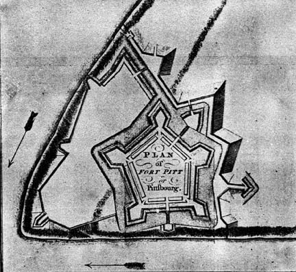
1772.1 PLAN OF FORT PITT OR PITTFBOURG, from Mante's History of the Late War, London 1772, reproduced in Winsor which is the image shown here; also reproduced in Egle. The Late War is the French and Indian War which ended circa 1763. This is the form of the fort begun in 1759 and the foundations and a surviving blockhouse can be seen today at Point State Park in Pittsburgh. Brown shows a sequence of plans dating from a manuscript sketch of Fort Duquesne in 1754 up to the 'Plan of the New Fort at Pittsburgh', November 1759, which is almost identical to this image. The history of the forts at Pittsburgh is complex. The first fort was a rudimentary one built by Virginians in 1754 and called Fort Prince George. It was destroyed the same year by the French who built Fort Duquesne. On December 1, 1758, the ruins of Fort Duquesne were officially renamed and from then on the Forks of the Ohio was called Pittsburgh. A temporary fort was built circa 1758-59 near the Monongahela River to house troops under the command of Colonel Hugh Mercer, and was called Mercer's Fort, see Brown, No. 35 and map 1758.9. This was followed by Fort Pitt, which took several years to build. It was abandoned by the British in 1772, taken over by Virginians in 1774 and renamed Fort Dunmore. It was again abandoned when the new Fort Fayette was constructed in 1791-92. This newer fort was used by General Anthony Wayne during the Indian wars in the Northwest Territory. |
|
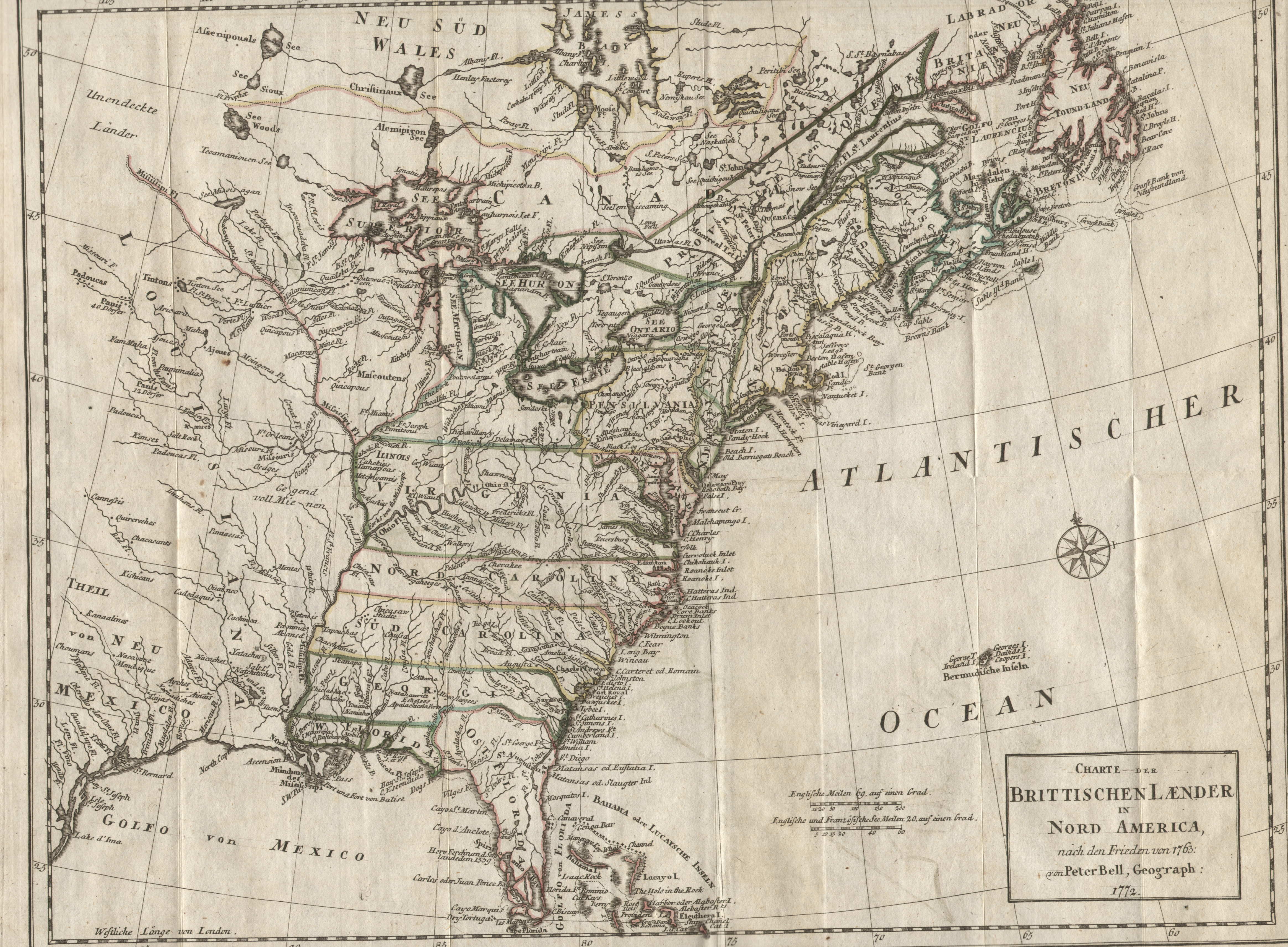
1772.2 A MAP OF THE BRITISH DOMINIONS IN NORTH AMERICA according to the treaty in 1763; by Peter Bell, geographer. 1772. This map showing the east from Newfoundland to Florida and west to the Mississippi appeared in The History of the British Dominions in North America, London 1773. There was also a re-engraved German edition shown here, identical to the English, both shown in McCorkle #772.1, 2. It is titled CHARTE DER BRITTISCHEN LAENDER IN NORD AMERICA, NACH DEN FRIEDEN VON 1763: von Peter Bell geograph: 1772; and was published in Geschichte der englishen Kolonien in Nord-Amerika, Leipzig 1775. The area shown is from Florida to Newfoundland and west to include the Mississippi. The colonies of Virginia, the Carolinas, Georgia and Florida all extend to the Mississippi River; some coastal and interior detail with towns, Indian villages, rivers and fishing banks. Pennsylvania extends to 43 degrees with an uneven western border; Philadelphia, York, and Pittsburgh are named. Sellers & van Ee #98. Originally folded, longitude west from London, blank verso. Scale: 1 inch = 185 miles. Size: 12 x 15 inches. |
|
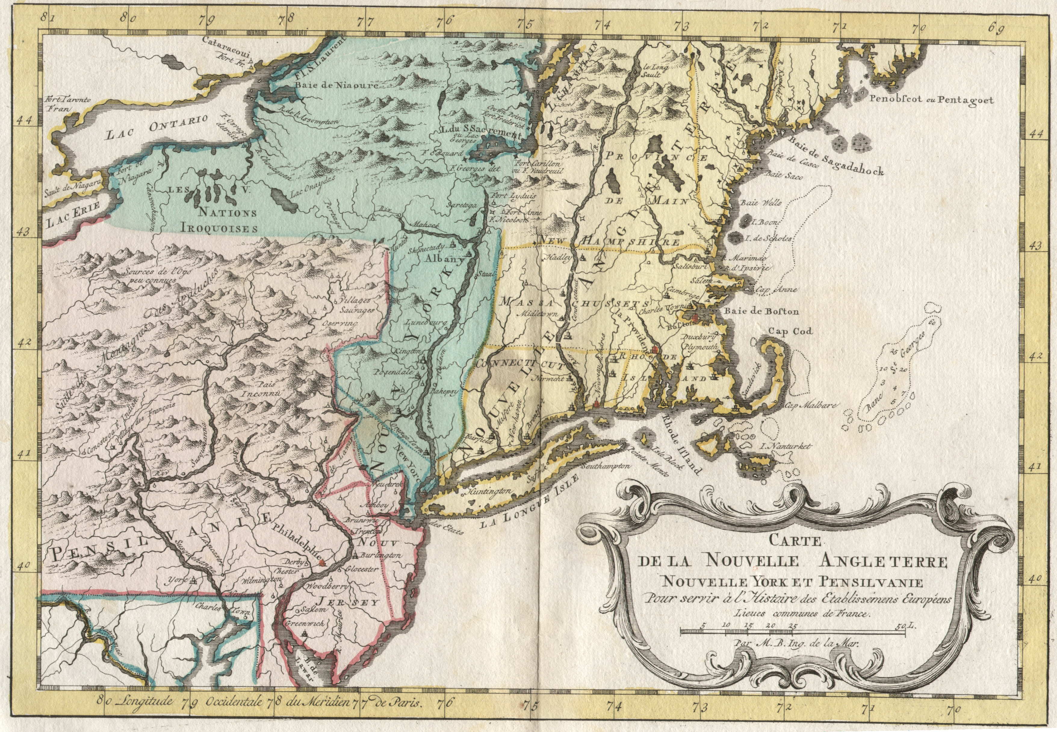
1773.1 CARTE DE LA NOUVELLE ANGLETERRE NOUVELLE YORK ET PENSILVANIE, POUR SERVIR A L' HISTAIRE DES ETABLISSEMENS EUROPEENS, par M. B. Ing, de la Mar. This map is a later edition of the 1757 map by Bellin, however the engraving is not identical. Apparently a new plate was cut using the old as a guide for a new book Atlas portatif pour servir a ... l'histoire philosophique et politique... by E. van Harrevelt, Amsterdam 1773 (McCorkle #773.1, #783.2). There were many versions of this Bellin map and the exact dating of this copy is uncertain. The boundary of Pennsylvania and New York is carried to the 43rd parallel and the Delaware separation is not shown. Delaware's separation from Pennsylvania was not shown on many colonial maps because both colonies had the same proprietor, a Penn. Longitude is west from Paris. Blank verso, the color is not original. Scale:1"=56 miles. Size: 9.5 x 14. |
| 1773.2 CARTE DE LA VIRGINIE, DE LA BAYE CHESAPEACK, et Pays Voisins Jacques Nicolas Bellin. This map of Chesapeake Bay is believed to be a companion to the one above. A small part of southeastern Pennsylvania is included. Like the map above, there was a previous 1757 issue. This version was seen at auction. | |
|
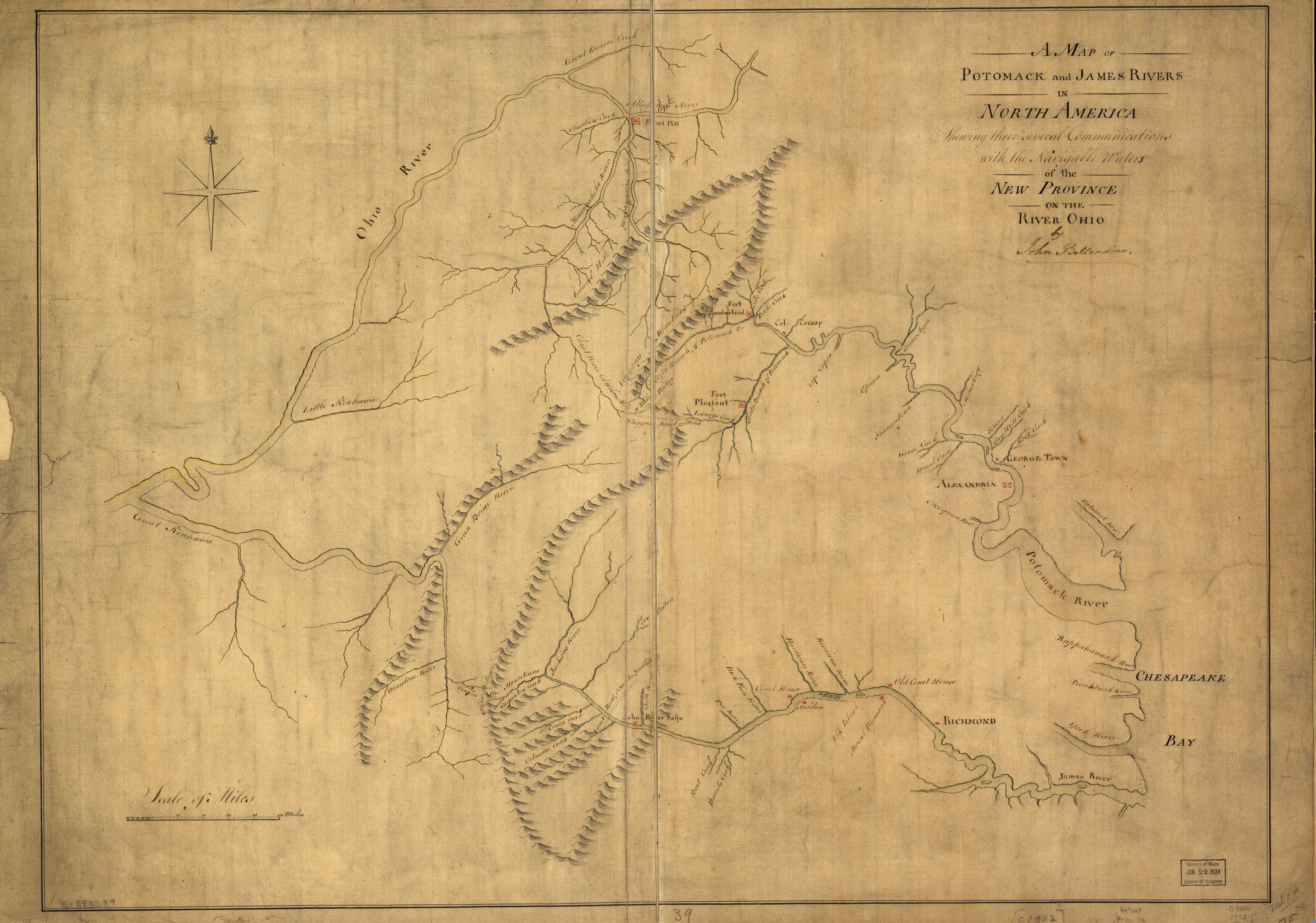
1773.3 A MAP OF POTOMACK AND JAMES RIVERS IN NORTH AMERICA SHEWING THEIR SEVERAL COMMUNICATIONS WITH THE NAVIGABLE WATERS OF THE NEW PROVINCE ON THE RIVER OHIO. By John Ballendine. This image is from the Library of Congress where this manuscript map is dated circa 1773. The map includes all of southwestern Pennsylvania north to Pittsburgh, and its purpose was to illustrate the lay of the rivers. Southwestern Pennsylvania at that time was considered part of Virginia, though only by Virginians. Ballendine was a wheeler-dealer and this map, copied from other sources, was apparently prepared to support one of his river transportation schemes. It is discussed in some detail by Burton and Stephenson. |
|
1774.1 TO THE HONORABLE HOUSE OF REPRESENTATIVES OF THE FREEMEN OF PENNSYLVANIA THIS MAP OF THE CITY AND LIBERTIES OF PHILADELPHIA WITH THE CATALOG OF PURCHASERS ...... by John Reed. Commonly called Reed's Plan of First Purchasers, this large landownership map (59 x 30 inches) was published in 1774. The small portion shown here contains one of the map's most interesting features, which is a scale given in perches, 100 perches to an inch. According to the OED, a perch is about 5.5 yards, and this measurement appears often on land survey maps of the period. This image comes from a reproduction of the original published in the Third Series of the Pennsylvania Archives 1894. The image is from the northwestern portion showing the Schuylkill River. The complete map shows Philadelphia and surrounding territory with an inset map of the city center and lists of the land owners and acreage owned. It was accompanyed by the pamphlet An Explanation of the Map of the City and Liberties of Philadelphia. Sellers & van Ee #1311, Wheat & Brun #457-58, M. P. Snyder, Figure 39. |
|
1774.2 PARTIE DU NORD DE L'AMERIQUE SEPTENTRIONALE POUR SERVIR A L'HISTOIRE PHILOSOPHIQUE ET POLITIQUE DES ETABLISSEMENS ET DU COMMERCE DES EUROPEENS DANS LES DEUX INDES, dresse par M. Bonne Mtre. de Mathematiques. Andre sculp. Tom. VI. et VII. A map from the Histoire of Abbe Raynal as the title says, this one shows all of eastern North America from Florida to Greenland. Several different versions are illustrated in McCorkle #774.1, 776.17, 777.17, 779.9, for Dutch, English, Italian, and other editions of Raynal's work. Pennsylvania, Philadelphia, and F. Duquesne are all named on this small scale map. Longitude east of Ferro, blank verso. Scale: 1 inch = 285 miles. Size: 12.75 x 9.5 inches. |
| 1774.3 THE BRITISH DOMINIONS IN NORTH AMERICA, from a late survey. Engrav'd for the Monthly Miscellany. This map has the familiar image from Newfoundland to a cutoff Florida and west to the Mississippi. Pennsylvania's boundary extends to 43 degrees and "Ft. du Quesne or Pitsburg" is named. McCorkle #774.2 | |
| 1774.4 A MAP OF THE BRITISH EMPIRE IN NORTH AMERICA. By Samuel Dunn, mathematician. London: Printed for Robt. Sayer, No. 53 in Fleet Street. as the Act directs 20 January 1774. This map resembles the Bonne map above (1774.2) but with more information on the English colonies added, Pennsylvania extends to the 43rd parallel. It appeared in Dunn's A New Atlas of the Mundane System, and in Jeffreys' American Atlas. McCorkle #774.3, 776.9, Sellers & van Ee #128-130 | |
| 1774.5 NORTH AMERICA FROM CAPE FLORIDA TO BAFFINS BAY, with the isles & limits conquer'd ceded & confirm'd to Great Britain by treaty. Tho. Kitchin sculp. Present State vol. 4. 293. This map comes from John Entick, The Present State of the British Empire... London 1774. Like the Dunn map, it shows eastern North America from Greenland to Florida. Philadelphia, Venango, and Pittsburgh are named. McCorkle #774.5 | |
| 1774.6 SKETCH OF THE RIVER AT ABOUT 42 N. SHOWING THE POSITION OF BOUNDRY MARKERS. The river referred to is the Delaware. This manuscript map is included in a report on establishing the 42 degree parallel as the New York - Pennsylvania border. The report was prepared by Samuel Holland (for New York) and David Rittenhouse (for Pennsylvania) and is in the Public Record Office (now the National Archives) London. Guthorn (1972) #59-1. | |
| 1774.7 CONNECTICUT CLAIMS IN PENNSYLVANIA, including the locations of the original grants in New England, comprehending part of Massachusetts, Rhode Island, New York and New Jersey. This map is listed in Edmund Thompson as appearing in An examination of the Connecticut claim to lands in Pennsylvania by Rev. Wm. Smith. Philadelphia 1774. |
| 1700's | 1710's | 1720's | 1730's | 1740's | |||||
| 1750-54 | 1755-59 | 1760-64 | 1765-69 | 1770-74 | 1775-79 | 1780-84 | 1785-89 | 1790-94 | 1795-99 |
| Home Page | 16th Century Maps | 17th Century Maps | 18th Century Maps | 19th Century Maps | 20th Century Maps | References |