 |
1775.1
A MAP OF PENNSYLVANIA EXHIBITING NOT ONLY THE IMPROVED
PARTS OF THAT PROVINCE BUT ALSO ITS EXTENSIVE FRONTIERS:
Laid down from actual surveys and chiefly from the late
map of W. Scull published in 1770; and humbly inscribed
to the Honourable Thomas Penn and Richard Penn... London.
Printed for Robt. Sayer & J. Bennett, 1775. This
version of William Scull's 1770 map (1770.1) was
published separately and appeared in Thomas Jeffreys' The
American Atlas published by R. Sayer & J.
Bennett 1776 and later. It also appeared in William Faden's
North American Atlas of 1777 which is the image
here from the Library of Congress. The same image was
used for map 1770.1 and the only difference between the
two is in the title. Sellers & van Ee #1296, Phillips
page 674. Scale: 1 inch = 6 miles. Size: 28 x 52 inches. |
 |
1775.2
NORTH AMERICA FROM THE FRENCH OF MR. D'ANVILLE IMPROVED
WITH THE ENGLISH SURVEYS MADE SINCE THE PEACE, London
printed for Robt Sayer & J. Bennett, Map and
Printsellers, No. 53 Fleet Street, as the act directs 10
June 1775 (McCorkle #775.2). This map is from The
American Atlas by Thomas Jefferys et al, published
by Sayer & Bennett London 1776, see page 585 in
Phillips. It was published posthumously as Jefferys died
in 1771 (Lister). The map originally appeared in 1755 (map
1755.5) and there were several versions. Jean Baptiste d'Anville
was a French cartographer published by Sayer &
Bennett who died in 1782. The 'peace' in the title refers
to the French & Indian war which ended circa 1763.
The state extends to the 43rd parallel and includes
Delaware as a county. The east coast is shown in this
closeup
. Longitude is west from London
at bottom, west from Ferro at top. The map is printed on
two sheets joined along the vertical centerline. Blank
verso. Scale: 1 inch = 100 miles. Size: 18 x 20 inches. |
| |
1775.3
BRITISH AMERICA, bounded and divided as proposed by the
author of American Independence. MDCCLXXV. John
Cartwright was the author of American Independence,
published in London 1775, and this is one of the earliest
maps addressing the topic. It shows the familiar region
from Newfoundland to a cutoff Florida and west to the
Mississippi. Cartwright carves out some fanciful states
on his map in addition to the original thirteen, most
with Indian names. A state comprising northwestern
Pennsylvania and western New York is called "Senekania."
McCorkle #775.3 |
 |
1775.4
A MAP OF THE PROVINCE OF NEW YORK WITH PART OF
PENSILVANIA, AND NEW ENGLAND, from an actual survey by
Captain Montresor, engineer, 1775. Publish'd as the Act
directs, June 10th. 1775, by A. Dury, Dukes Court St.
Martins Lane London. P Andrews sculp. Despite the title
this two-sheet map includes only the northeastern tip of
Pennsylvania on the bottom sheet. The map also appeared
in William Faden's North American Atlas
published in 1777, which is the image shown here from the
Library of Congress. There is also a 1777 French
version by Le Rouge. John Montresor was an officer in the
British Army and its chief engineer in America. He was a
friend of the famous painter John Singleton Copley, a
Loyalist, who did a portrait of him now in the Detroit
Institute of Arts. In the portrait Montresor holds a copy
of Field Engineer, a textbook of the time.
McCorkle #775.9, Sellers & van Ee #1066, Phillips
page 675, Guthorn (1972) #144-4. |
| |
1775.5
PARTIE OCCIDENTALE DU CANADA ET SEPTENTRIONALE DE LA
LOUISIANE AVEC UNE PARTIE DE LA PENSILVANIE, par le Sr. d'Anville.
Venise, Par P. Santini 1775. This map of the midwest
appears in Santini's Atlas universel, Paris 1776,
and is a companion to map 1776.4 below. Sellers & van
Ee #133, 134 |
 |
1775.6
To the Merchants & Insurers of the City of
Philadelphia this CHART OF THE DELAWARE BAY AND RIVER,
containing a full and exact description of the Shores,
Creeks ... and bearings of the most considerable
landmarks ... from the capes to Philadelphia ... is
dedicated by a friend to trade and navigation Joshua
Fisher 1775. This is Fisher's initial publication of his
navigation chart and it was followed by a host of copies
from 1776 on by Faden, Le Rouge, Sayer & Bennett, etc.
The image here is from Faden's North American Atlas
of 1777 from the Library of Congress. This
version
appeared in The Gentleman's
Magazine for July 1779. See Sellers & van Ee #1353-60,
1363-65,1372-73; Docktor
#280H5. |
 |
1775.7
MAP OF THE PROVINCE OF PENSILVANIA. This undated and
anonymous map is thought to be from the Gentleman's
Magazine, London, circa 1775, although the general
appearance could date it to the 1760's. The southern
boundary reflects the Mason-Dixon survey (1768), though
the western boundary is placed just west of Pittsburgh;
the northern boundary is not marked. The map has a number
of reference points that likely refer to companion text
and appear to be connected to boundaries. The western and
southern boundaries are marked Q, R, S, for example. A
diagonal line runs from the Susquehanna R to Lake Erie P.
A broken line marked by many letters A, B, N, O, etc.,
appears in the east. No latitude or longitude markings,
blank verso. Scale: 1 inch = 55 miles. Size: 4.5 x 7.5
inches. |
 |
1775.8
A NEW & ACCURATE MAP OF NORTH AMERICA; from the best
authorities. Engraved by J. Cary. Published by Jas. Ma?wan
& Wm. Davis. This map is a direct copy of map 1766.1
and engraved by the well known English mapmaker John Cary
(circa 1754-1835). Cary was most active right around the
turn of the century so this map is likely one of his
earliest cartographic efforts. Its source and exact
dating are not known, but it is probably circa 1775, when
Cary would have been around 20 years old, and may be from
a later edition of John Entick's The General History
of the Late War, first published in 1766, and also
in 1775 and 1779. The rough bottom shows it was removed
from a book. The map shows the eastern United States and
southern Canada south to a cutoff Florida and west to
beyond the Mississippi. Pennsylvania extends north to the
43rd parallel with Venango, Bufflers T., Pitsburg,
Wyoming, Ft. Granville, and Philadelphia named. The
coloring on this copy is probably not original. Longitude
west from London, blank verso. Scale: 1 inch = 265 miles.
Size: 7.75 x 9 inches. |
 |
1776.1
A MAP OF THE COUNTRY ROUND PHILADELPHIA INCLUDING PART OF
NEW JERSEY NEW YORK STATEN ISLAND & LONG ISLAND, from
the September, 1776, issue of Gentlemen's Magazine,
London for D. Henry. The map shows Pennsylvania west to
York and north to include most all of New Jersey. The
title would imply that Philadelphia was more important
than the entire state of New Jersey, which was probably
true at the time. The same map with only slight
differences appeared in The Scots Magazine,
Edinburgh, A. Murray 1776. Phillips page 676, 699.
Longitude west from London, blank verso. Scale: 1 inch =
26 miles. Size: 7 x 8.75 inches. |
 |
1776.2
AN ACCURATE MAP OF THE PRESENT SEAT OF WAR, BETWEEN GREAT-BRITAIN
AND HER COLONIES IN NORTH AMERICA. Engraved for the
Universl. Mage. 1776. This map of the Great Lakes region
appeared in the October 1776 issue of Universal
Magazine. No map maker or engraver is identified. Pennsylvania extends to the 43rd parallel;
Philadelphia, Pitsburg, Franks T., Harris T., Easton,
Venango are named. The northwest territories, Ohio,
Indiana, etc. are given to Virginia. The map extends to 40 south, so a slice of southern Pennsylvania does not appear. McCorkle 776.1, Sellers & Van Ee #135. Blank verso, longitude west from London. Scale: 1 inch = 95 miles. Size: 10.25 x 13.25 inches. |
| |
1776.3
THE THEATRE OF WAR IN NORTH AMERICA, with the roads, and
tables, of the superficial contents, distances, &ca.
by an American. London. Printed for Robt. Sayer and Jno.
Bennett, No. 53 Fleet Street, as the Act directs 20th
Novr. 1776. This map, of the familiar region from
Newfoundland to Florida and west to the Mississippi, was
orginally published as a broadside with three columns of
text below the map. McCorkle illustrates five states of
this map: 776.2, 776.15, 776.26; Sellers & van Ee #144-45,
160. The table mentioned covers a large portion of the
map and is titled Evan's Polymetric Table of America. One
of the broadside versions of this map is also illustrated
in Pritchard & Taliaferro #54. |
 |
1776.4
CARTE GENERALE DU CANADA, DE LA LOUISIANE, DE LA FLORIDE,
DE LA CAROLINE, DE LA VIRGINIE, DE LA NOUVELLE ANGLETERRE,
ETC. par le Sr. D'Anville, a Venise, par P. Santini 1776.
This map is a later version
of D'Anville's original 1755 map.
The small text in the lower left corner reads: "N. B. Les traits rouges marquent las subdivision de cette Carte generale representee plus au large dans les trois suivantes." In the right corner is an inset of the Hudsons Bay - Greenland area. The main map covers the eastern United States from Newfoundland to a cutoff Florida and to beyond the Mississippi. This map was published in Santini's Atlas
universel, 1776. McCorkle #776.3, Seller & van
Ee #136-37. Blank verso, "longitude occidentale du premier meridien", apparently west from Ferro. Scale: 1 inch = 102 miles. Size: 18.75 x 25.5 inches. |
| |
1776.5
THE THEATRE OF WAR, IN THE PROVINCES OF MASSACHUSETS-BAY,
CONNECTICUT, NEW-YORK, NEW-JERSEY, PENSILVANIA, MARILAND,
VIRGINIA &C. By Peter Bell. London, published as the
Act directs, 1st Septr. 1776. By Andrew Dury, Dukes Court,
St. Martins Lane. W. Haydon sculpt. The general features
of this map of the northeast are copied from Evans 1755
map. Pennsylvania extends to about 42d 40m with its
western boundary passing through Pittsburgh and following
the Allegheny north. McCorkle #776.5 |
| |
1776.6
AN ACCURATE MAP OF CANADA AND THE ADJACENT COUNTRIES
EXHIBITING YE PRESENT SEAT OF WAR BETWEEN GREAT BRITAIN
& HER COLONIES by T. Bowen. A magazine map which
appeared in the General Magazine, January 1776,
and also in Lottery Magazine, v. 1, 1776. It
shows the region from Newfoundland to Carolina and west
to include the Great Lakes. There is little detail,
Philadelphia is named. McCorkle #776.6 |
 |
1776.7
A GENERAL MAP OF THE NORTHERN BRITISH COLONIES IN AMERICA.
which comprehends the Province of Quebec, the Government
of Newfoundland, Nova-Scotia, New-England and New-York...;
with a title above the border THE SEAT OF WAR IN THE
NORTHERN COLONIES, CONTAINING THE PROVINCE OF QUEBEC,
NEWFOUNDLAND, NOVA-SCOTIA, NEW-ENGLAND, NEW-YORK, NEW-JERSEY,
PENNSYLVANIA, &CA. London Printed for R. Sayer &
J. Bennett... 1776. Pennsylvania just makes it onto the
bottom left edge of this map of eastern Canada. McCorkle
(#776.11, 794.12) illustrates 1788, 1794 versions also
where the map is retitled A NEW AND CORRECT MAP OF THE
BRITISH COLONIES IN NORTH AMERICA. This map, and the one
below, also appeared in the American Military Pocket
Atlas, intended for use by British officers in the
field. Sellers & van Ee #143. Image from the Heritage
Map Museum CD by permission. |
 |
1776.8
A GENERAL MAP OF THE MIDDLE BRITISH COLONIES IN AMERICA.
containing Virginia, Maryland, the Delaware Counties,
Pennsylvania and New Jersey...; with a title above the
border THE SEAT OF WAR IN THE MIDDLE BRITISH COLONIES,
CONTAINING VIRGINIA, MARYLAND, THE DELAWARE COUNTIES
&CA. London Printed for R. Sayer & J. Bennett...
1776. This is the companion map to the one above, and
contains an inset of the western Great Lakes. The main
map shows the region from New York to Virginia and west
to include Ohio. All of Pennsylvania is shown, and the
southeastern portion is included in a detail from the map
in Ristow. This image is from the Library of Congress. |
| |
1776.9
SCHAUPLATZ DES KRIEGS ZWISCHEN ENGELLAND UND SEINEN
COLLONIEN IN AMERICA nach rightigen Carten gezeichnet und
in diese Form gebracht von I:C: Iaeger. Franckfurt am
Mayn, zu finden in der Iaegernschen Buchhandlung 1776.
Gestochen vor I:C: Berndt in Franckfurt. A map to
illustrate the Revolutionary War from Johann Christian
Jaeger's Handbook. McCorkle #776.14 |
| |
1776.10
CARTE NOUVELLE DE L'AMERIQUE ANGLOISE contenant tout ce
que les Anglois possedent sur le continent de l'Amerique
Septentrionale savoir le Canada, la Nouvelle Ecosse ou
Acadie, les treize Provinces Unies qui sont: les quatres
colonies de la Nouvelle Angleterre 1. New Hampshire, 2.
Massachusetsbaye, 3. Rhode-Island, & 4. Conecticut, 5.
la Nouvelle York, 6. Nouvelle Jersey, 7. Pensilvanie, 8.
les comtes de Newcastle Kent et Sussex sur la Delaware, 9.
Mariland, 10. Virginie, 11. la Caroline Septentrionale,
12. la Caroline Meridionale et 13. Georgie; avec la
Floride. Gravee exactement d'apres les determinations
geographiques dernierement faites par Matthieu Albert
Lotter a Augsbourg. This map of the east coast appears in
Suetter and Lotter atlases. Note the careful enumeration
of the thirteen colonies in the title. Pennsylvania's
boundary extends north to about 43 degrees and the
western boundary ends at the Allegheny Front. McCorkle #776.19,
Sellers & van Ee #141 |
| |
1776.11
A MAP OF THE PRESENT SEAT OF WAR IN NORTH AMERICA. A map
from Westminster Magazine, August 1776 showing
the region from Newfoundland to a cutoff Florida and west
to the Mississippi. Pennsylvania's northern boundary
extends to about 43 degrees, "Ft. du Quesne or
Pitsburg" and Venango are named. McCorkle #776.21 |
| |
1776.12
A NEW MAP OF NORTH AMERICA, engraved for the Abbe Resnal's
History of the Settlements of the Europeans in the East
& West Indies. This map differs from maps used in
earlier editions of Raynal's history (1774.2); the
coverage is from Newfoundland to Florida and west to the
Mississippi and considerably more detail is added.
McCorkle #776.23 |
 |
1776.13
A MAP OF THE MIDDLE BRITISH COLONIES IN NORTH AMERICA.
First published by Mr. Lewis Evans, of Philadelphia, in
1755; and since corrected and improved, as also extended,
with the addition of New England, and bordering parts of
Canada, from actual surveys now lying at the Board of
Trade. By T. Pownall MP. with a topographical description
of such parts of North America as are contained in this
map. Printed & published according to Act of
Parliament for J. Almon in Piccadilly, London. March 25th.
1776. Engraved by Jas. Turner in Philadelphia. This was a
major revision of Evans' map which was extended to
include New England up to Maine. The map was accompanied
by A Topographical Description of such parts of North
America as are contained in the (annexed) Map... . This
reprinted much of Evans' Analysis... augmented
by Pownall. In 1784, Pownall prepared a manuscript of a
new edition that was never published. The manuscript came
into the possession of William Darlington, who founded
the Darlington Memorial Library at the University of
Pittsburgh, and was published in 1949 by the university.
It was accompanied by a facsimile of this 1776 map with
revisions marked by Pownall, and by a facsimile of
Bernard Roman's A General Map of the Southern British
Colonies in America. McCorkle #776.24, Sellers & van
Ee #710. This image is from the Library of Congress. |
 |
1776.14
A MAP OF THE PROVINCE OF NEW YORK, reduc'd from the large
drawing of that Province, compiled from actual surveys by
order of His Excellency William Tryon Esqr. Captain
General & Governor of same, by Claude Joseph Sauthier;
to which is added New-Jersey, from the topographical
observations of C. J. Sauthier & B. Ratzer. Engraved
by William Faden, (successor to the late Mr. Thos.
Jefferys) 1776. London, publish'd according to Act of
Parliament, August 1st. 1776, by Wm. Faden, corner of St.
Martin's Lane, Charing Cross. The Pennsylvania boundary
is set at the 42nd parallel with the note "Bounds of
Pennsylvania by Patent." The land to the north in
New York is called Country of the Six Nations, and the
Penns ceded the land to the 43rd parallel to New York
largely to avoid having to deal with the Iroquois. The
road network in southeastern Pennsylvania is illustrated
on this map. This image is from the Libray of Congress.
McCorkle #776.25, Sellers & van Ee #1047. |
 |
1776.15
A GENERAL MAP OF NORTH AMERICA; from the latest
observations. Printed according to Act of Parliament,
Jany. 27th 1776. Engraved by Jn. Lodge from the late Mr.
Jeffrys geographer to the King. This is a modification of
map 1776.3 with Florida now cutoff and a modified tables
of distances (McCorkle #776.15, Sellers & van
Ee #160). There were several versions of this map as described by McCorkle. The copy shown here is from the 1778 edition of the North American and West-Indian Gazetteer, 2nd ed. London: G. Robinson, 1778. The first edition appeared in 1776 and had the same map except with the publisher and date on the bottom, missing on the second edition copy shown here. The region from James Bay to the Gulf of Mexico and west to beyond the Mississippi is shown. Pennsylvania extends to the 43rd parallel with an irregular western boundary that is the mirror image of the Delaware River eastern boundary. The title is along the top outside the neat line. Blank verso, longitude west from London. Scale:1 inch = 166 miles. Size: 11 x 15 inches. |
 |
1776.16
A PLAN OF THE CITY OF PHILADELPHIA, THE CAPITOL OF
PENNSYLVANIA, from an actual survey. By Benjamin Easburn,
Surveyor General; 1776. London, Andrew Drury, 1776. This
map contains an inset of Fisher's Delaware Bay map.
Illustrated on pages 120-21 of Nebenzahl &
Higginbotham, and an excellent reproduction is in van
Erman and in M. P. Snyder, Figure 42. There was a
contemporary French version PHILADELPHIE, PAR EASBURN...
by Le Rouge which is shown in this image from the Library
of Congress, however it lacks the Fisher inset. Although
this map is attributed to Benjamin Eastburn, he had
nothing to do with it, and even his name is spelled wrong.
It is actually a copy of map #1762.3, see M. P. Snyder,
page 96. Sellers & van Ee #1312-13, Phillips page 699,
Guthorn (1972) #144-6. |
| |
1776.17
(Western Pennsylvania) This is an untitled manuscript map,
possibly a fragment, showing the Ohio River from
Pittsburgh to south of Wheeling. It is attributed to John
Montresor, a British army engineer and the original is in
the Library of Congress. It is illustrated in Brown #50
and is probably the map listed by
Docktor
#276M1. |
 |
1776.18
(Delaware and Chespeake Bays) An untitled anonymous
manuscript map of the Delaware and Chesapeake region
showing roads. Listed in Phillips page 675 dated 177_,
dated 1776 at the Library of Congress where this image
comes from. This map could also possibly be the one
listed on page 677 of Phillips dated 178_? As with the
French & Indian War, there are a number of
Revolutionary War anonymous manuscript maps prepared by
soldiers on both sides showing aspects of the
Philadelphia campaign, see Docktor
#276A2, 27_A5.0A, #27_A5, #27_A7.
|
 |
1776.19
CANADA IIE. FEUILLE. PLATE XXXV B32.The title and plate information lie outside the neat line across the top of this French map. According to the Library of Congress, this map comes from Rigobert Bonne, published by Jean Lattre, Paris 1776; so, that dating is used here. However, the map appears older and by appearance would date to the 1750s For example, Fort Duquesne is identified rather than Fort Pitt, so the map is likely based on old maps of Jacques Bellin. It shows the eastern United States to beyond the Mississippi with a misshapen Florida. River networks are shown and Indian tribes named. Five scales are shown at lower right. Intaglio print, blank verso. Longitude east from (probably) Paris. Scale: 1 inch = 120 miles. Size: 11.25 x 17 inches.
|
 |
1777.1
NEUE CHARTE VON PENSYLVANIEN, MARYLAND, NORD UND SUD
CAROLINA, GEORGIEN, FLORIDA U. LUISIANA. NACH DEN
ZEICHNUNGEN DERER HERREN W. SCULL, I. FREY, P. YEFFERSON,
H. MOUZON, LEIST, ROSS UND D'ANVILLE. This is an
anonomous German edition of a map probably originally by
D'Anville who died in 1782 (Lister), and the dating is
uncertain. The W. Scull map appeared in 1770 which places
an early bound and preparation probably predates the
early 1780's because the name United States does not
appear; the colonies are named individually. The sources
for the map are listed in the title and these names
appear in maps from Faden's North American Atlas
of 1777, so this map likely dates circa 1775-80. Despite
the German title some features retain English spellings.
The prime meridian is not identified but the longitude
appears to be west from Ferro. Blank verso. Scale: 1 inch
= 220 miles. Size: 7.5 x 12 inches. |
| |
1777.2
A NEW MAP OF THE BRITISH COLONIES IN NORTH AMERICA,
shewing the seat of the present war, taken from the best
surveys, compared with and imroved from manuscipts of
several noblemen and gentlemen. By John Andrews. London.
Publish'd according to Act of Parliament, Jany. 16th.
1777: by John Andrews, at Mr. Blisset's No. 29 Long Acre.
and Andrew Dury in Duke's Court, St. Martin's Lane,
Charing Cross. Drawn & Engraved by John Andrews.
Pennsylvania ends at 42 degrees on this detailed map of
the east coast and west to Lake Michigan. There is also a
1781 version. McCorkle #777.1, 781.1; Sellers & van
Ee #146-48, Guthorn (1972) #138. |
| |
1777.3
CARTE DE L'AMERIQUE SEPTLE. pour servir a l'intelligence
de la guerre entre les Anglois et les insurgents. Dediee
a Mgr. Sartine Ministre de la Marine, par M. le Chr. de
Beaurain, geographe du Roi, et son pensionnaire. 1777. A
Paris chez l'Auteur rue Gillecoeur quartier St. Andre des
Arts. Jean de Beaurain died in 1772, so this map may have
been prepared earlier. It shows the familar area from
Newfoundland to Florida and west to beyond the
Mississippi. There is an inset closeup of the
Pennsylvania-New York-New Jersey area. The Pennsylvania
boundary extends to 43 degrees and the western boundary
of the southern states extends to the Mississippi.
McCorkle #777.3, Sellers & van Ee #149 |
 |
1777.4
CARTE DU THEATRE DE LA GUERRE ENTRE LES ANGLAIS ET LES
AMERICAINS: dressee d'apres les cartes Anglaises les plus
modernes, par M. Brion de la Tour, Ingenieur-Geographe du
Roi. 1777 A Paris chez Esnauts et Rapilly, rue St.
Jacques a la Ville de Coutances. This map includes only
eastern Pennsylvania shown with its present boundaries.
The image is from the Library of Congress. McCorkle #777.6,
778.1, 779.3, 782.8; Sellers & van Ee #728-30. |
 |
1777.5
THE BRITISH COLONIES IN NORTH AMERICA. Engraved by
William Faden, M.DCCLXXVII. This map comes from The
North American Atlas published in London, 1777. It
shows the familiar region from Newfoundland to Florida
and west to beyond the Mississippi. The northern boundary
of Pennsylvania is placed slightly above 42 degrees, and
the western boundary slightly beyond the 80th meridian.
There were subsequent versions, some illustrated by
McCorkle #777.8, Sellers & van Ee #732-33, also
illustrated in Fite & Freeman #59. This image is from
the Library of Congress where all of Faden's atlas can be
viewed. |
| |
1777.6
CARTE DES POSSESSIONS ANGLOISES DANS L'AMERIQUE
SEPTENTRIONALE pour servir d'intelligence a la guerre
presente traduite de l'Anglois par J. Leopold Imbert 1777
A Paris chez Mondhare Rue St. Jacques pres St. Severin. A
map of the eastern United States with an inset of
southern Florida and the Caribbean. A border line shows
the English colonies ending at the Appalachians. A 1783
version of this map changed the title to CARTE GENERALE
DES ETATS UNIS..., with the imprimatur of J. B. Eliot.
McCorkle #777.9, 783.7; Sellers & van Ee #53, 749 |
| |
1777.7
PROVINCE DE NEW-YORK en 4 feuilles par Montresor. A Paris
chez Le Rouge Ingr. Geog. du Roi rue des Grands Augustins
1777. This is the Le Rouge French version of map 1775.5,
appearing in Le Rouge's Atlas ameriquain
septentrional. McCorkle #777.16; Sellers & van
Ee #1068. |
 |
1777.8
CARTE DETAILLEE DES POSSESSIONS ANGLOISES DANS L'AMERIQUE
SEPTENTRIONALE construite d'apres les dernieres relations
et les cartes particulieres de ces provinces, pour l'intelligence
de la guerre actuelle entre les Anglois et leurs colonies.
A Paris ches Esnauts et Rapilly, rue St. Jacques a la
Ville de Constances. 1777. A French map of the eastern
United States attributed to Rene Phelippeaux, with later
states. This map was reissued in 1779 with the title CARTE GENERALE DES COLONIES ANGLOISES DANS L'AMERIQUE SEPTENTRIONALE. This image is from the Library of Congress.
McCorkle #777.18, 778.12, 779.11; Sellers & van Ee #150-51.
|
 |
1777.9
A MAP OF THE PROVINCES OF NEW-YORK AND NEW-JERSEY, with a
part of Pennsylvania and the province of Quebec. from the
topographical observations of C. J. Sauthier. Augsburg
engraved and published by Matthew Albert Lotter 1777.
This is a German version of Sauthier's 1776.14 map of New
York. It is a two sheet map, with Pennsylvania included
on the southern sheet with the title. The image shows the
two sheets joined. McCorkle #777.20; Sellers & van Ee
#1048. Image from the Heritage Map Museum by permission. |
 |
1777.10
THEATRE DE LA GUERRE EN AMERIQUE SEAT OF WAR IN AMERICA.
This map of uncertain date and origin is oriented with
northeast at the top, with a banner Supplement au Courier
de L'Europe No. XXXII Vol. II, apparently a French
publication. It includes northern Maryland, Delaware,
eastern Pennsylvania, New Jersey, southern New York and
parts of Connecticut, Massachusetts, and New Hampshire.
Its intent is to show the theatre of the Revolutionary
War around New York. This image is from the Library of
Congress. McCorkle #777.21; Sellers & van Ee #731. |
| |
1777.11
CARTE NOUVELLE DES POSSESSIONS ANGLOISES EN AMERIQUE...
Traduite de l'Anglois d'apres Thos. Gefferys, geographe
du prince de Galles, revue et corrigee par M. Moithey...
Avril 1777. This is a later version of a 1757 map (1757.2)
with the title changed. McCorkle 777.10, 780.5; Sellers
& van Ee #155-56). |
 |
1777.12
SEAT OF WAR IN THE ENVIRONS OF PHILADELPHIA: By Thos.
Kitchin, Senr. Hydrographer to his Majesty. For the
London Magazine 1777. Printed for R. Baldwin at the Rose
Pater Noster Row. This war map appeared in the London
Magazine in 1777 and is illustrated in Fite &
Freeman #67 and in Johnson (1974). It includes the area
from Trenton to Lancaster and 30 minutes north and south
of 40 degrees. The road network is shown in detail. It
was likely published to illustrate the campaign against
Philadelphia. Sellers & van Ee #1314, Phillips page
699. Longitude west from London, blank verso. Scale: 1
inch = 10 miles. Size: 7.5 x 10 inches. |
 |
1777.13
A SURVEY OF THE CITY OF PHILADELPHIA AND ITS ENVIRONS
shewing the several works constructed by His Majesty's
troops, under the command of Sir William Howe, since
their possession of that city 26th. September 1777,
comprehending likewise the attacks against Fort Mifflin
on Mud Island, and until it's reduction. 16th November
1777. (Signed by) John Montresor Chief Engineer. P.
Nicole Fecit. This is a manuscript map with several
insets showing fortifications and this image is from the
Library of Congress. Sellers & van Ee #1315. |
| |
1777.14
A MAP OF THAT PART OF PENSYLVANIA NOW THE PRINCIPLE SEAT
OF WAR IN AMERICA, wherein may be seen the situation of
Philadelphia, Red Bank, Mud Island, & Germantown.
From an actual survey made by Nichos. Scull, surveyor of
the Province of Pensylvania. This map was engraved by L.
Jackson. This map is illustrated in M. P. Snyder, Figure
49, and is not really a copy of the Scull & Heap map
although it shows the same area. Sellers & van Ee #1317 |
 |
1777.15
A PLAN OF THE CITY AND ENVIRONS OF PHILADELPHIA. Engraved
and published by Matthew Albert Lotter. 1777. This is
Lotter's version of the Scull & Heap map, apparently
issued in both English and German versions per Seller
& van Ee #1322. This image is from the Heritage Map Museum CD
by permission; a more detailed image can be seen at the Darlington Library.
|
| |
1777.16
(Philadelphia) An untitled map that appeared in editions
of J. F. W. Des Barres Atlantic Neptune. It
covers the area around Philadelphia and neighboring New
Jersey and Delaware and was intended to show the
navigable Delaware up to Trenton. It is laid out like the
1687 Holme map, and there is a manuscript version in the
British Library titled A MAPP OF PENSILVANIA IN AMERICA
with inset titled THE CITY PHILADELPHIA; both are
illustrated in M. P. Snyder, Figures 187, 188. Sellers
& van Ee #1323; also see
Docktor
#279D2.02. |
 |
1777.17
BATTLE OF BRANDYWINE, 11TH SEPTR. 1777, in which the
rebels were defeated by the Army under the command of
Genl. Willm. Howe. The Library of Congress has five
manuscript maps of this title concerning the Battle of
Brandywine, Sellers & van Ee #1334-36, 1339-40, this
is one of them. They were apparently used to prepare a
published map of the same title by William Faden in 1778,
although John Montresor is credited with the manuscript
versions. The Faden engraved map is illustrated in M. P.
Snyder, Figure 189. For several manuscript maps on
Brandywine, see Docktor
#277W2, #277W5, #277R7, #277W2.0A
- 0B; and Guthorn (1972) #132. |
| |
1777.18
1ST. & 2D. POSITION OF THAT PART OF THE ARMY ENGAGED
ON THE 19TH SEPT. 1777. 3D & 4TH POSTN. SEPT. 19. A
manuscript map attributed to Friedrich von Wangenheim
prepared during the Battle of Paoli, September 20, 1777.
Sellers & van Ee #1343 |
 |
1777.19
A SKETCH OF THE BATTLE OF GERMAN. TN., 4th October 1777
where the Rebels were repulsed. Two manuscript maps of
similar title are in the Library of Congress on the
Battle of Germantown. Sellers & van Ee #1344-45. One
attributed to John Montresor is illustrated on page 57 of
Marshall & Peckham and is shown here from Winsor (1884).
See
Docktor
#277H5 also. Guthorn (#51-D7)
lists a crude manuscript map showing the disposition of
American forces and held at the Huntington Library. It is
titled "Plan of Germantown Battle of Octob. 1775";
no explanation for the wrong date. For a listing of other
manuscript maps on the Germantown battle, see Guthorn (1972)
#132. |
| |
1777.20
A PLAN OF THE ATTACKS AGAINST FORT MIFFLIN ON MUD ISLAND
which surrendered 16th, November 1777 to the Kings troops...
Drawn by T. Wheeler, ensn., 40th regt. This is a
manuscript map in the Library of Congress, Sellers &
van Ee #1347. There is another anonymous manuscript map
titled PLAN OF FORT MIFFLIN ON MUD ISLAND also, Sellers
& van Ee #1348; Docktor
#278A3. |
 |
1777.21
(Pennsylvania and New York) The Library
of Congress
holds a set of 10 German maps
and views circa 1777 attributed to Johann Martin Will
with the catalog title Zehn Karten und Ansichten den
Schlachtfelden des amerikanischen Unabh ngigkeitskreiges
in den Staaten Pennsylvanien und New York. Included
are maps of
Brandywine
: Bataille am Brandywyne Fluss
d. 11 Sept. 1777, and
Philadelphia
: Grundriss von Philadelphia
der Haupt-Stadt in Pensylvanien und umliegenden Gegend.
This German map is based upon Scull & Heap's 1752 map
and drawn to explain the war to a German audience. It
shows the forts on the river islands and troop formations
near Germantown; and is illustrated in M. P. Snyder,
Figure 50, with a 1778 date. Some of these are probably
related to the Hessian manuscript maps listed in
Docktor
#277R5, #277W6. |
 |
1777.22
A SURVEY OF THE CITY OF PHILADELPHIA & its environs
comprehending the neck formed by the rivers of Delaware
& Schuylkill; together with Province, Carpenter, and
Mud Islands. & the several batteries & works
constructed thereon. Philadelphia 15th. Decr. 1777. John
Montresor Chief Engineer. This is a manuscript map
showing exactly what the title says. It is reproduced in
Hulbert(1907) which is the image here, though only the
northern part including Philadelphia is shown. Phillips
page 700, it is also illustrated in Guthorn (1972) page
35. See
Docktor
#27_M5 for a possibly related
manuscript map in the Clements Library which is also
listed in Guthorn (1972) #80-21. |
 |
1777.23
PLAN OF THE OPERATIONS OF GENERAL WASHINGTON, AGAINST THE
KINGS TROOPS IN NEW JERSEY. from the 26th. of December
1776 to the 3d. January 1777. by William Faden. London
Publishd...15th. April 1777 by Wm. Faden. The map
includes the Newtown - Middletown area of Bucks County
and shows the road network in detail. Illustrated on page
93 of Nebenzahl & Higginbotham. This image is from
the Library of Congress, which also has a manuscript
version of this map. |
 |
1777.24
A PLAN OF THE CITY AND ENVIRONS OF PHILADELPHIA. Surveyed
by N. Scull and G. Heap. Engraved by Willm. Faden 1777.
London Publish'd... March 12th. 1777 by W. Faden. This is
Faden's version of the Scull & Heap map 1752.1 and is
illustrated on pages 116-7 of Nebenzahl &
Higginbotham and on Figure 45 in M. P. Snyder. The image
here is from the Library of Congress, Phillips page 700. |
 |
1777.25
PROGRESS OF THE BRITISH ARMY FROM THE LANDING IN ELK
RIVER TO THE TAKING POSSESSION OF PHILADELPHIA ANNO 1777.
This manuscript map shows Howe's route of march north
from the Chesapeake to surround the city. The road
network is shown in detail. It is attributed to Capt.
John Andre, the same British officer later executed in
the Benedict Arnold affair. Illustrated on page 55 of
Marshall & Peckham. This image is from the Library of
Congress. There are two manuscript maps attributed to
Andre concerning the Mud Island operations listed in
Docktor
#277A2, #277A2.0A. A military
journal of Andre is at the Huntington Library. It
contains several manuscript maps on Brandywine,
Germantown, the Philadelphia fortifications, and the
operations against Mud Island; see Guthorn (1972) #2. |
| |
1777.26
PLAN OF THE GENERAL ATTACK ON FORT MIFFLIN..., a
manuscript map of the mouth of the Schuylkill River with
Hog, Mud, and Reedy Islands. The map shows the fort on
Mud Island although that identification is wrong
according to Marshall & Peckham, where this map is
illustrated on pages 60-61. The fort was actually on Port
Island. The map is attributed to Simon Fraser, a loyalist.
This is possibly the map listed in
Docktor
#277A8. |
 |
1777.27
(Valley Forge) On page 63 in Marshall & Peckham is an
anonymous, untitled and undated manuscript map of the
encampment at Valley Forge during the winter of 1777-78,
probably done by a British spy who actually visited the
camp. It indicates Washington's headquarters and shows
the encampment as three long rows of shacks or tents.
Many historians have tried to portray this dismal time as
a moral victory for Washington. The map was apparently
found in the papers of General Henry Clinton and is now
in the William Clements Library. The Pennsylvania
Archives, in Manuscript Group 11 #730, has a facsimile
map "Contemporary Map of the Encampment at Valley
Forge 1777-1778," by a French engineer, from the
original in the Library of Hon. Samuel W. Pennypacker, LL.D.,
copyright by the Pennsylvania Society of the Sons of the
Revolution, 1898. Roads, Flatland Ford, River, Bridge,
encampments, old headquarters are shown. This appears to
be a different contemporary manuscript map of Valley
Forge.
Docktor
#278A9 lists a manuscript map
of Valley Forge in the Jared Sparks papers at Cornell
University Library dated 1778, and also one (#278A9.0C)
in the Library of Congress. Guthorn (#51-D2) lists a
color wash manuscript map 14 x 20 inches, and (#51 D 4) a
13 x 15 inch manuscript map dated to 1778; both of Valley
Forge and held at the Historical Society of Pennsylvania.
Winsor illustrates a composite map of Valley Forge shown
here prepared from at least two sources. |
| |
1777.28
(Eastern Pennsylvania & New Jersey) An untitled
manuscript map showing the road network between
Philadelphia and Perth Amboy. It is attributed to John
Montresor and probably prepared circa 1777-78.
Illustrated on the front end paper in Marshall &
Peckham. |
| |
1777.29
A NEW, ACCURATE & IMPROVED MAP OF BERKS COUNTY IN
PENNSYLVANIA...Layd down from the most certain
information and the best of authorities, during the
severe campaign...anno...1776...and bearing No Allegiance
to the Crown. Text in the left hand corner reads "True
Turnpike Distances from Reading" and lists certain
landmarks. The middle left corner reads "this
Country was organized in the year 1752 from lands aquired
in Indian Purchases June 7, 1684~Moungougsins Rles., Sept.
7, 1732~Sckuykill Indians, Oct. 25, 1736~the Five Nations,
Aug. 22, 1749~The Nine Nations." Far left corner
edge reads "Moft humbly compiled and executed by J.R.
Rowe MCMLXXVII." This map was seen for sale as a
reproduction and its authenticity has not been verified. |
 |
1777.30
(Philadelphia area) An untitled and undated manuscript
map showing the operations of the British army in their
march on Philadelphia. The Library of Congress, where
this image is from, call the map "Operations of the
British army, from the 25th August to 26th Sept. 1777,"
date it 1777? and attribute it to John Montresor.
Phillips page 699, listed in
Docktor
#277M3, Guthorn (1972) #132-2. |
 |
1777.31
THIS IS NOT GIVEN AS AN ACCURATE MAP, but only to afford
an idea of the progress of the army from the landing at
Elk to the taking of possession of Philadelphia. The
brown lines are the supposed marches of the rebels. This
manuscript map with the notation title is in the Library
of Congress where it is dated 1777, the date of the
operations described. It was apparently in the papers of
the British General Grey. See Guthorn (1972) #132-1-3. |
 |
1777.32
A NEW AND ACCURATE MAP OF THE PRESENT SEAT OF WAR IN
NORTH AMERICA, COMPREHENDING NEW JERSEY, PHILADELPHIA,
PENNSYLVANIA, NEW-YORK &C. This map is from the Universal
Magazine of June 1777. Only the eastern most parts
of Pennsylvania are included from just west of
Philadelphia. The road network is shown and the various
New York - New Jersey boundaries considered are
illustrated along with the old East and West Jersey line.
The edge coloring on this copy is not original. Scale: 1
inch = 8 miles. Size: 14 x 11 inches. |
 |
1777.33
(Philadelphia, Mud Island) Mud island lay in the Delaware
River near Philadelphia and was the site of Fort Mifflin,
one of the city's defenses against British attack.
According to Winsor (1884), there are several manuscript
maps in the Jared Sparks papers at Cornell University
done by a French Major Fleury which show the island and
the British advance. A facsimile of one appearing in
Winsor is shown here along with a more detailed view of
the
fort
. Also, see
Docktor
#277F6, #277F6.0A-0D, #278F5;
and Guthorn #18. Guthorn (#51-D3) lists a manuscript map
held by the Historical Society of Pennsylvania labeled
"Esquisse des forts sur le delaware, Forts Mercer
& Mifflin", and which he titles "Plan of
the Attack on Mud Island in the Delaware Novr 1777." |
 |
1777.34
PLAN OF THE ENGLISH LINES NEAR PHILADELPHIA 1777, by
Lewis Nicola. A manuscript map depicting the line of
redoubts built by the British around the city after
taking Philadelphia. There are a couple insets showing
details of redoubt construction. Original at the
Historical Society of Pennsylvania, illustrated in M. P.
Snyder, Figure 51. The image here is from Winsor. This is
likely the map listed in Docktor
#277A8.0A, also see
Docktor
#278A8, Guthorn #31. |
| |
1777.35
THE TAKING OF MISS MUD ILAND, sold by W. Humphrey 227
Strand London. Although this has attributes of a crude
map, showing ostensibly the fort on Mud Island firing on
some ships, it is really a rather risque political
cartoon. Illustrated by M. P. Snyder, Figure 54. |
| |
1777.36
BROUILLON OU PLAN DU CAMP DE VALLIE FORGE, by Louis
LeBeque de Presle Duportail. A pen and ink manuscript map
of the Valley Forge area rather hard to decipher. The
original is at the Historical Society of Pennsylvania,
illustrated in M. P. Snyder, Figure 191. Guthorn (#15)
says this may be the initial plan of Valley Forge.
Docktor
#278D1, #278D7, #278D7.01 - 02. |
| |
1777.37
AN ACCURATE PLAN OF THE COUNTRY BETWEEN NEW YORK AND
PHILADELPHIA; with the Dispositions of the Forces:
Extracted from the Gazette of Tuesday, Febr. 25th 1777,
by Stephen Pyle. An illustration of troop movements
between the two cities, Docktor
#277P4, #277P5. |
| |
1777.38
PLAN OF THE BATTLE OF BRANDYWINE, a manuscript map in the
Royal Library, Winsor Castle, attributed to Robertson
"Captain of Engineers." In the same collection
is a second manuscript map attributed to Robertson titled
SKETCH OF THE ATTACK AT GERMAN TOWN 4TH OCT. 1777.
Docktor
#277R8, #277R8.0A. Archibald
Robertson was a British engineering officer who also
prepared a watercolor panoramic view of Philadelphia
illustrated in M. P. Snyder, Figure 58. |
 |
1777.39
(Brandywine) The Historical Society of Pennsylvania has
an untitled manuscript map believed to be Washington's
map of the Brandwine area and a facsimile in Winsor is
shown here. The map is inscribed "Laid down at 200
ps. in an Inch, the 27th day of August, An. Domi 1777, pr
Jacob Broom, survr, N. Castle." There is a table of
distances and an accompanying legend said to be in
Washington's handwriting and given in Winsor. See also
Guthorn #9 and Guthorn (1972) #132 for Brandywine
manuscript maps. |
| |
1777.40
(Philadelphia) Guthorn (#51-D5, 6) lists two manuscript
maps held at the Historical Society of Pennsylvania. One
titled "Roads about Skippack, Germantown &c.
taken October 1777; and the other just "Roads round
Philadelphia." The first shows troop positions,
camps, and movements; the second is a crude road map. |
| |
1777.41
A MAP OF THE SEAT OF WAR IN THE PROVINCE OF YORK, JERSEY
AND PENNSYLVANIA; WITH THE INTERIOR COUNTRY AS FAR AS
ALBANY. From the best Authorities. London Printed
according to the Act of Parliament for J. Almon, in
Piccadilly, March 1st., 1777. This small (4 x 6.5 inches)
map appeared in the obscure English magazine The
Remembrancer or, Impartial Repository of Public Events. Guthorn
(1972) #154-4. |
| |
1777.42
A PLAN OF MUD ISLAND AND FORT MIFFLIN WITH THE SIEGE
THEREOF AND ITS EVACUATIONS THE 15TH. OF NOVEMBER 1777...,
a manuscript map attributed to Charles Blaskowitz, a
colonial surveyor; see Guthorn (1972) #11-14. |
| |
1777.43
(Southeast Pennsylvania) A manuscript map showing the
Delaware, Susquehanna, and the road network of the
southeast is in the diary of Andrew Snape Hamond, a
British naval officer involved in the landings of Howe's
troops at Elk River and subsequent operations on the
Delaware. The diary is held by the University of Virginia
Library; see Guthorn (1972) #52. There are a couple
similar anonymous and undated manuscript maps in the
Clements Library, see Guthorn (1972) #132-7,8. |
| |
1777.44
(Delaware River) An untitled and undated manuscript map
circa 1777 attributed to Montresor showing the Bristol -
Burlington area of the Delaware just north of
Philadelphia. Guthorn (1972) #80-20. |
| |
1777.45
MAP OF HUDSON'S RIVER WITH THE ADJACENT COUNTRY. This is
a map from Scot's Magazine published in 1777.
The same map was in the Gentleman's Magazine of
January, 1778. It includes a large chunk of eastern
Pennsylvania shown as extending to the 43rd parallel. The
main focus of the map is the river, coverage extends from
Crown Point south to Philadelphia and west as far as
Lancaster. Phillips page 323. |
| |
1777.46
A PLAN OF THE PROGRESS OF THE ROYAL ARMY FROM THEIR LANDING AT ELK FERRY TO PHILADELPHIA 1777. Surveyed and drawn by order of Major General Sir William Erskine by Charles Blaskowitz. This is a recently discovered manuscript map that appeared at auction in 2010. Its preparation is dated to late 1777 or early 1778 and it shows the course of General Howe's movements to invest Philadelphia. A portion of it is reproduced in Brown & Cohen. |
 |
1778.1
LA PENSILVANIE EN TROIS FEUILLES. TRADUITE DES MEILLEURES
CARTES ANGLAISES. A MAP OF PENNSYLVANIA EXHIBITING NOT
ONLY THE IMPROVED PARTS OF THAT PROVINCE BUT ALSO ITS
EXTENSIVE FRONTIERS... Paris chez La Rouge. This version
of William Scull's 1770 map was published by Georges
Louis le Rouge in Atlas Ameriquain Septentrional,
Paris 1778, and is the French version of the map from
Thomas Jeffreys' The American Atlas published by
R. Sayer & J. Bennett in 1776. The image here is from
a modern black line reproduction. The map is large (26 x
52 inches) and only the regions around
Pittsburgh
and
Lancaster
are shown here. William used
information about western Pennsylvania gained during the
French and Indian War to update his grandfather Nicholas
Scull's 1759 map. Thus, the locations of Braddock's
defeat and Bouquet's victory are shown near Pittsburgh,
but not much else. By contrast, the region around
Lancaster and York is filled with the names of towns and
other features. Blank verso. Scale: 1 inch = 6 miles.
Sellers & van Ee #1297, Phillips page 675. |
 |
1778.2
AN EXACT MAP OF NEW JERSEY, PENNSYLVANIA, NEW
YORK, MARYLAND & VIRGINIA FROM THE LATEST SURVEYS, J.
Lodge, Sculp. This map is from The History of America
by William Russell, published by Fielding &
Walker, London 1778. It covers an area from New York City
south to include all the Chesapeake Bay and west to the
Allegheny Mountains including southeastern Pennsylvania,
all of New Jersey and Delaware, eastern Maryland and
Virginia. A large number of towns are located and named,
mountains and shorelines are shown in shaded relief.
Delaware is not named in the title nor on the map, though
its boundaries are shown. See Phillips pages 590, 859. Western Pennsylvania is shown on the accompanying map 1778.28 below.
Longitude is west from London. Blank verso. Scale: 1 inch
= 38 miles. Size: 8 x 10 inches. |
 |
1778.3
AN EXACT MAP OF NEW ENGLAND, NEW YORK, PENSYLVANIA &
NEW JERSEY, FROM THE LATEST SURVEYS. J. Lodge sculp. This
is a companion map from the same book as the one above.
Northeastern Pennsylvania is included and shown extending
north to 42d 45m. McCorkle #778.5. Longitude is west from
London. Blank verso. Scale: 1 inch = 38 miles. Size: 8 x
10 inches. |
| |
1778.4
PARTIE SEPTENTRIONALE DES POSSESSIONS ANGLOISE
EN AMERIQUE, pour servire d'intelligence a la guerre
presente entre les Anglois et leur colonies dressee sur
les meilleurs cartes du pays traduite de l'Anglois, de
Michel a Paris a l'Hotel de Soubise 1778. A French map
attributed to Brion de la Tour. It includes northeastern
Pennsylvania. There is a companion map, PARTE MERIDIONALE...,
of the coast down to Carolina which includes a strip of
southeastern Pennsylvania. These maps were seen at
auction attributed to the French engravers Ambrose
Verrier and Francoise Perrier. McCorkle #778.2; Sellers
& van Ee #161. |
 |
1778.5
CARTE DU THEATRE DE LA GUERRE ACTUEL entre les
Anglais et les Treize Colonies Unies de l'Amerique
Septentrionale dressee par J. B. Eliot ingenieurs des
Etats Unis 1778. A Paris chez Mondhare Rue St. Jacques a
la Ville de Caen. This French map is often considered the
first to name the United States (Etats Unis); however the
name does not appear in the title (which has Treize
Colonies) and the map shows only part of the northeast
centered on New York. Map 1778.10 would appear to have a
better claim since Etats Unis appears in the title and
the map shows a wider region, but still not the entire
United States. This map includes only eastern
Pennsylvania with counties, rivers, and some towns named.
This image is from the Library of Congress. McCorkle #778.3,
781.6; Sellers & van Ee #734-36. |
| |
1778.6
MAPA GEOGRAFICO QUE COMPREHENDE LA NUEVA INGLATERRA,
NUEVA YORK, NUEVA JERSEY, PENSILVANIA, MARYLAND Y PARTE
DE VIRGINIA: por Don Tomas Lopez. Madrid ano de 1778.
This is one of the rare Spanish maps of English America.
A note on the map says it is based upon those of Evans,
Mitchell, Jeffreys, and d'Anville. It shows the region
from southern Maine to the Chesapeake and west to include
part of Lake Erie. It is quite detailed with many names.
McCorkle #778.7 |
 |
1778.7
LE COLONIE UNITE DELL: AMERICA SETTENTRLE. di
nuova projezione a SS. EE. li Signori riformatori dello
studio di Padova Venezia 1778 Presso Antonio Zatta con
privilegio dell' eccellentissimo Senato. This twelve sheet map is from
Antonio Zatta's Storia Dell'America Settentrionale
1778, and is a copy of John Mitchell's 1755 map. Slightly
later Zatta published Atlante Novissimo, Venice
1778, a ten sheet edition of John Mitchell's map, where
LE COLONIE... is the title sheet and an east coast map is
titled IL CANADA..., see map 1800.2. Sheet (Fogl) V is titled LA
PENSILVANIA, LA NUOVA YORK, IL JERSEY SETTENTRIOLE, CON
LA PARTE OCCIDENTALE DEL CONNECTICUT, MASSACHUSETTS-BAY E
L'IROCHESIA and is shown here. Pennsylvania extends to
the 43rd parallel with its western boundary a mirror
image of the eastern. The eastern counties, rivers, and
some towns are named as well as many Indian villages.
This map is illustrated in McCorkle #778.11 along with
several of the other sheets, also in Portinaro &
Knirsch. "Colonie Unite dell America" has been
credited by some as the first map to both show and name
the entire new United States. Another sheet showing
Virginia to Carolina includes a strip of southern
Pennsylvania. Sellers & van Ee #163-64. Longitude
east with Philadelphia at about 302d 30m, blank verso.
Scale: 1 inch = 33 miles. Size: 12 x 16.5 inches. |
| |
1778.8
ALLGEMEINE CHARTE VON NORD AMERIKA ALS DEN SITZ
DES KRIEGES ZWISCHEN DEN KONIGL. ENGL. TRUPPEN U: DEN
PROVINZIALEN. Nach der in London mit Konigl. privilegio,
nach der Parlements acte von 7. Jan. 1776, zu haben in
Hamburg in der Mollerische Buchhandlung, 1778. T. A.
Pingeling sculp Hamb: This map is a German copy of map
1776.3 with English place names. It also appeared as a
broadsheet above three columns of text. McCorkle (#778.13)
compares several versions; also Sellers & van Ee #142.
|
| |
1778.9
SPECIAL KARTE VON DEN MITTLEREN BRITTISCHEN
COLONIEN IN NORD AMERIKA. Pingeling sculp, Hamburg 1778.
This map is from Beschreibung des brittischen Amerika,
Wolfenbuttel 1778, by Christian Leiste. It depicts the
northeast from Chesapeake Bay to southern Maine.
Pennsylvania is included, with its modern boundaries,
west to the Susquehanna. McCorkle #778.14 |
| |
1778.10
CARTE DU CANADA ET DES ETATS-UNIS DE L'AMERIQUE
SEPTENTRIONALE par le Sr. Robert de Vaugondy.... A Paris
chez Fortin... 1778 (McCorkle #778.16). This is an
updated version of map 1753.2 and one of the first maps
to name the United States (Etats-Unis) in the title.
McCorkle shows both versions. |
| |
1778.11
A CHOROGRAPHICAL MAP OF THE NORTHERN DEPARTMENT
OF NORTH AMERICA drawn from the latest and most accurate
observations. This peculiar map with southeast at the top
is attributed to Bernard Romans. Pennsylvania just barely
makes it onto the right edge. There was also a 1780
Amsterdam version, both illustrated by McCorkle #778.17,
780.14. |
| |
1778.12
CARTE DES TROUBLES DE L'AMERIQUE LEVEE PAR ORDRE DU
CHEVALIER TRYON CAPITAINE GENERAL ET GOUVERNEUR DE LA
PROVINCE DE NEW-YORK ENSEMBLE LA PROVINCE DE NEW-JERSEY
par Sauthier et Ratzer traduite de l'Anglais. A Paris
chez Le Rouge Ingr. Geographe du Roi Rue des Gds.
Augustins 1778. Beauble scripsit. This is the Le Rouge Atlas
Ameriquain edition of map 1776.13. McCorkle #778.18 |
 |
1778.13
MAPPA GEOGRAPHICA PROVINCIAE NOVAE EBORACI AB ANGLIS NEW
YORK dictae ... Claudii Josephi Sauthier cui accedit Nova
Jersey... Homannianor. Heredum 1778. This is the Homann
Heirs version of map 1776.14 and published in Atlas
Geographicus Maior, Norimbergae: Homann Erben, 1778.
McCorkle #778.19; Sellers & van Ee #1049. Image from
the Heritage Map Museum by permission. |
 |
1778.14
A NEW MAP OF THE WESTERN PARTS OF VIRGINIA, PENNSYLVANIA,
MARYLAND AND NORTH CAROLINA; comprehending the river Ohio,
and all the rivers, which fall into it; part of the River
Mississippi, the whole of the Illinois River, Lake Erie;
part of the Lakes Huron, Michigan &c. And all the
country bordering on these lakes and rivers. By Thos.
Hutchins, Captain in the 60 Regiment of Foot. London
Published according to Act of Parliament...1778 by T.
Hutchins. Engraved by T. Cheevers. This map was made to
accompany A topographical description of Virginia,
Pennsylvania, Maryland, and North Carolina...,
published by Hutchins in 1778 and is probably his best
known map. It includes western Pennsylvania as far east
as the Allegheny Front. The map is illustrated in Brown #51,
Stephenson & McKee, listed in Phillips page 677. This
image is from the Library of Congress. A map titled A
TABLE OF DISTANCES BETWEEN FORT PITT, AND THE MOUTH OF
THE RIVER OHIO is also in A topographical description...,
see
Docktor
#278H2. For a biography of
Hutchins, see Quattrocchi in the References. |
| |
1778.15
A PLAN OF THE CITY OF PHILADELPHIA. This map by John
Norman appeared in The Philadelphia Almanack for
the Year 1778. Sellers & van Ee #1316, Wheat &
Brun #459, illustrated in M. P. Snyder, Figure 62. |
| |
1778.16
ENVIRONS DE PHILADELPHIE. par Scull et Heap, Publie &
Londres par Faden en 1777. Traduit d l'Anglais. A Paris,
chez le Rouge Ingr. Geographe du Roi, 1778. Another Scull
& Heap copy, this map appeared in Le Rouge's Pilote
americain septentrionale. Sellers & van Ee #1318,
illustrated in M. P. Snyder, Figure 47. |
| |
1778.17
PLAN OF THE CITY OF PHILADELPHIA AND ITS ENVIRONS shewing
its defenses during the years 1777 & 1778, together
with the siege of Mud Island on the River Delaware. This
is another manuscript map signed by John Montresor and
prepared by Nicole similar to map 1777.13. Sellers &
van Ee #1324, Docktor
#278N1. |
| |
1778.18
BATTLE OF BRANDYWINE in which the rebels were defeated,
September the 11th. 1777, by the army under the command
of General Sr. Willm. Howe. Engraved by Wm. Faden, 1778.
This battlefield map exists in two quite different
versions, see Sellers & van Ee #1337-38. It is based
on map 1777.17. One version is illustrated on page 112 of
Nebenzahl & Higginbotham. |
 |
1778.19
BRITISH CAMP AT TRUDRUFFRIN FROM THE 18TH. TO THE 21ST.
OF SEPTEMBER 1777, with the attack made by Major General
Grey against the rebels near White Horse Tavern on the 20th.
of September. Drawn by an officer on the spot. W. Faden,
1778. The Library of Congress has a manuscript draft of
this map which is shown here, see Sellers & van Ee #1341-42.
The printed map appeared in Faden's Atlas of Battles
of the American Revolution, and is illustrated on
page 115 of Nebenzahl & Higginbotham, and in Figure
190 in M. P. Snyder. It also appears in Winsor, shown
here
.
Docktor
#277A6.0A is a related
anonymous manuscript map in the New York Public Library. |
| |
1778.20
PLAN OF GENL DU PORTAIL. PLAN OF THE POSITION OF VALLEY
FORGE AFTER JANY. 1778. A manuscript map attributed to
Louis Duportail, Sellers & van Ee #1349, Guthorn #15.
This is possibly another version of map #1777.36. |
| |
1778.21
THE COURSE OF DELAWARE RIVER FROM PHILADELPHIA TO CHESTER,
exhibiting the several works erected by the rebels to
defend its passage, with the attacks made upon them by
His Majesty's land & sea forces. 1778. This is a map
by William Faden in Atlas of Battles of the American
Revolution. The Library of Congress also has a
manuscript draft, Sellers & van Ee #1361-62, and
there are other contemporary manuscript maps, see M. P.
Snyder, Guthorn (1972) #63-2. There is an inset titled A
Sketch of Fort Island; a later version by Faden (1779)
changed this to A Plan of Fort Mifflin on Mud Island.
Illustrated by M. P. Snyder, Figure 55. See also
Docktor
#285F1, #285F2, #285F7;
Guthorn (1972) #132. |
 |
1778.22
PLAN DE LA RETRAITE DE
BARREN HILL EN PENSILVANIE: ou un d tachement de deux
mille deux cent hommes sous le G'al LaFayette tois
entour par l'Arm e angloise sous les G'als Howe,
Clinton et Grant le 28 May 1778 / par M'r Capitaine, A.d.C.
du G n ral LaFayette. This manuscript map from the
Library of Congress by Michel Capitaine du Chesnoy covers
Barren Hill and vicinity (i.e. Montgomery County) with
Chestnut Hill and Germantown. Place-names are in English.
This was part of Howe's campaign to capture Philadelphia.
Illustrated in M. P. Snyder, Figure 192; and in Guthorn,
page 10, who also lists 5 extant manuscript versions of
varying size and title. Also see
Docktor
#278A5.0A - 0E. |
 |
1778.23
(Northcentral Pennsylvania) This is an untitled and
anonymous manuscript map, dated circa 1778, of the
Sunbury area and western New York showing the east and
west branches of the Susquehanna River. It is held at the
Library of Congress where this image comes from. The LOC
title for it is PLAN OF PART OF WESTERN FRONT. This is
probably the map listed in Phillips page 677 dated 1779?,
and in
Docktor
#278A1. |
| |
1778.24
PLAN DER GEGEND UND STADT VON PHILADELPHIA, a German
version of Scull & Heap's map appearing in Geschichte
der kriege in und ausser Europa, Nurnberg, G. N.
Raspe 1778. Phillips page 701, also illustrated on Figure
48 in M. P. Snyder. Figure 43 in Snyder is a small and
plain map of the Philadelphia street grid titled
GRUNDRISS DER STADT PHILADELPHIA from Raspe, whose "rarity
exceeds its importance." |
 |
1778.25
TO THE AMERICAN PHILOSOPHICAL SOCIETY THIS MAP OF THE
PENINSULA BETWEEN DELAWARE & CHESOPEAK BAYS, with the
said bays and shores adjacent drawn from the most
accurate surveys is inscribed by John Churchman. The
dating of this map is uncertain and the Library of
Congress, the source of this image, date it circa 1778.
This map is part of the LOC collection belonging to the
French general Rochambeau, commander of the French army
in America during the Revolution. Only the southeastern
tip of Pennsylvania is included. |
 |
1778.26
PLAN OF PART OF THE RIVER DELAWARE FROM CHESTER TO
PHILADELPHIA, in which is mark'd the position of His Majs.
ships on the 15th. of November 1777. The obstructions to
the navigation of the river, laid down by the rebels, are
also mark'd. This is a manuscript map by John Hunter in
the Library of Congress dated 1778. It is very decorative
and Hunter must have been an aspiring artist; actually he
was a British naval officer with a long career through
the Napoleonic wars winding up a vice admiral. Sellers
& van Ee #1366. Docktor
#278H1, Guthorn (1972) #63-2. |
 |
1778.27
A CHOROGRAPHICAL MAP, OF THE COUNTRY, ROUND PHILADELPHIA.
By B-Romans. The map is dated from ads which appeared for
it in newspapers of the time. Valley Forge is shown and
called "Grand American Winter Camp January 1778."
The map was republished circa 1780 with the added title
CARTE PARTICULIERE DES ENVIRONS DE PHILADELPHIE. K.
Klockhoff sculps. A Amsterdam, chez Covens et Mortier, et
Covens, junior. This image of the Klockhoff print comes
from the Library of Congress. Wheat & Brun #304,
Phillips page 701, Guthorn #41-7,8. |
 |
1778.28
AN EXACT MAP OF THE FIVE GREAT LAKES WITH PART OF
PENSILVANIA, NEW YORK, CANADA AND HUDSONS BAY TERRITORIES
FROM THE BEST SURVEYS, J. Lodge, Sculp. This map includes
northern Pennsylvania south to 40d and is a companion to
maps 1778.2, 3 above, all from The History of America
by William Russell, published by Fielding &
Walker, London 1778. Russell's book contains other
regional maps of similar title which do not include
Pennsylvania. Longitude is west from London. Blank verso.
Scale: 1 inch = 105 miles. Size: 8 x 10 inches. |
| |
1778.29
(Delaware River) There are two untitled manuscript maps
in the Pennsylvania Archives (Record Group 27) attributed
to French engineer Jean Louis Ambrose Villefranche, and
dated 1778. The catalog title is DELAWARE RIVER DEFENSE.
The maps show fortifications along the Delaware River
south of Philadelphia including Hog Island. See
Docktor
#278V4, 279V8; also Guthorn #47.
A reproduction with discussion of one map is on pages 178-179
in Shirk. |
| |
1778.30
BRITISH CAMP ON WEST BANK OF SCHUYLKILL RIVER AT
PHILADELPHIA. An anonymous and undated manuscript map of
the Philadelphia area in the Clements Library, see
Docktor
#27_A5.0A. |
| |
1778.31
(Southeast Pennsylvania) An untitled, anonymous and
undated manuscript map in the Clements Library showing
southeast Pennsylvania, see
Docktor
#27_A5; also #27_A7 for a
possibly related manuscript map of Philadelphia. |
| |
1778.32
PLAN OF WASHINGTON'S POSITION. Mr Parker, late a mercht
in Virginia, now in Philadelphia. An undated manuscript
map in the Clements Library showing the area west of
Philadelphia and Valley Forge, see
Docktor
#27_P5. |
| |
1778.33
KENSINGTON TO MUD ISLAND, an anonymous manuscript map in
the Scavenius Collection of Dartmouth College.
Docktor
#278A6. |
| |
1778.34
(Lancaster County) An untitled anonymous manuscript map
in the Erskine-DeWitt collection of the New York
Historical Society, number 130, shows a "Road from
Little Britain Meetg. Ho. to Peach Bottom Ferry."
See Robert Erskine below. Docktor
#278E5. |
| |
1778.35
PLAN OF THE REDOUBTS NEAR PHILADELPHIA 1ST APRIL 1778. A
manuscript survey map of the British lines; held at
Harvard Library and listed in Guthorn (#51-D1). |
| |
1778.36
A MAP OF NEW JERSEY, PENNSYLVANIA, NEW YORK, MARYLAND
& VIRGINIA from the latest and best Surveys. This map
appeared in An Impartial History of the Present War
in America. London and Newcastle, 1778-80, three
volumes. Guthorn (1972) #170-4. |
| |
1778.37
BRITISH CAMP ON WEST BANK OF THE SCHUYLKILL RIVER AT
PHILADELPHIA. By: Sir Henry Clinton. An undated
manuscript map in the Clinton papers at Clements Library;
see Guthorn (1972) #21. |
| |
1778.38
A COMPLETE PLAN OF PART OF THE PROVINCE OF PENNSYLVANIA,
EAST AND WEST JERSEY SHEWING THE TRANSACTIONS OF THE
ROYAL ARMY UNDER THE COMMAND OF THEIR EXCELLENCIES SIR W.
HOWE AND SR. HY. CLINTON...This plan is compiled from the
original surveys of Scull, Biddle, Fisher, Cox, Millage,
Dennis, Williams, Morgan, Rue, Clinton, Ryartson, &
several principal surveyors by I. Hills, vol. with the
Brigade of His Majestys Foot Guards. New York August 1778.
This is a large (20 x 62 and 20 x 22 inches) two part
manuscript map held at the Clements Library. John Hills
also produced two related maps which appeared in Faden's Atlas
of Battles of the American Revolution: A PLAN OF
PART OF THE PROVINCES OF PENNSYLVANIA, AND EAST &
WEST NEW JERSEY..., and SKETCH OF THE SURPRISE OF
GERMANTOWN, BY THE AMERICAN FORCES...; see Guthorn (1972)
#57-5,6,7. Hills was a prolific draughtsman who worked
under Montresor and produced a large number of
Revolutionary War maps and sketches, Guthorn has 51
entries for him. |
| |
1778.39
(Delaware River) A manuscript map in the Huntington
Library is attributed to George Spencer, a colonial
Loyalist. It shows the ship channel, islands and
fortifications. Guthorn (1972) #106-1. |
| |
1778.40
A DRAUGHT AND CALCULATIONS OF AN ENTRENCHMENT FROM
DELAWARE TO SCHULKILL RUN IN ANGLES TO THE BEST ADVANTAGE
THE GROUND WILL PERMIT. An undated manuscript map circa
1777-78 apparently drawn as a Philadelphia fortification
guide and attributed to Montresor by Guthorn (1972) #80-25;
original in the Atwater Kent Museum, Philadelphia. |
 |
1778.41
DRAUGHT OF THE RIVER DELAWARE FROM CHESTER TO
PHILADELPHIA, Engraved for Moore's New and Complete
Collection of Voyages and Travels. This map appears on a
sheet with four other harbor maps titled Various
Plans and Draughts of Cities, Towns, Harbours &c
Drawn from the Latest Authorities, engraved by
Thomas Conder. The maps are: Plan of the Harbour of New-York
and Parts adjacent, The Town & Harbour of Boston
&c., Draught of the River Delaware from Chester to
Philadelphia (this map), Plan of the Harbour of Charles
Town, South Carolina, and Plan of the City & Harbour
of Havana, Capital of Cuba. Each map includes city plans,
islands, channels and more. The sheet appears in A
new and complete collection of voyages and travels:
containing all that have been remarkable from the
earliest period to the present time... with an account of
the rise and progress of navigation among the various
nations of the earth... comprehending an extensive system
of geography, describing, in most accurate manner, every
place worthy of notice in Europe, Asia, Africa, and
America... by John Hamilton Moore; London, Printed
for the proprietors and sold by A. Hogg, 1778. The
Library of Congress has two listings for Moore's Travels,
1778 and 1785. This map was also seen at auction dated
1784 from Millar's New Complete and Universal
System of Geography. Sellers & van Ee #189. No
longitude markings, this copy is discolored and has a wreath around the title which some printings lack. Scale: 1
inch = 3.5 miles. Size: 2.75 x 4 inches. |
 |
1779.1
MAP OF THE EUROPEAN SETTLEMENTS IN NORTH AMERICA, by Thos.
Kitchin, Hydrographer to His Majesty, from A
Philosphical and Political History of the Settlements and
Trade of the Europeans in the East and West Indies,
by Abbe Raynal, Dublin, 1779 per page 590 of Phillips (McCorkle
#779.9). The complete map covers the eastern part of
North America from Greenland to Florida with settlement
confined to the eastern seaboard. Philadelphia and Ft.
Duquesne appear. In the Great Lakes region and westward
are numerous Indian names. A comment by L. Ouinipigon
alludes to the northwest passage: 'R. of ye Assenpouels
supposed to fall into the Western Ocean'. The map has a
garland style title cartouche and compass rose at bottom
and was originally folded. Although McCorkle's dating is
followed here, an earlier version of this map dates to
1776 from a London edition of Raynal's work published by
T. Cadell. That map has the date 1776 at the bottom,
missing on this later printing. Longitude is west from
London at the bottom, west from Ferro at top. Blank verso.
Scale: 1 inch = 320 miles. Size: 13.5 x 12 inches. |
| |
1779.2
THEATRE DE LA GUERRE EN AMERIQUE, avec les Isles Antilles;
projette et assujettie aux observations, par Mr. Bonne
hydrographe du Roi... 1779. This is a later version with
a different title of map 1771.2. McCorkle #779.2, Sellers
& van Ee #165. |
| |
1779.3
COLONIE INGLESI. This is a small Italian playing card map
of uncertain date showing the northeast; little is named
and nothing in Pennsylvania. McCorkle (#779.5) provides a
few details and references. |
| |
1779.4
CARTE DU THEATRE DE LA GUERRE PRESENTE EN AMERIQUE
dressee d'apres les Nouvelles Cartes Anglaises. par L.
Denis geographe et auteur du Conducteur Francais Dediee
et presentee a Monsieur Le Noir.... Basset en 1779. A map
extending from Newfoundland to Florida, but only as far
west as Lake Michigan. There is a large inset of southern
New England and New York, eastern Pennsylvania and all of
New Jersey. The boundaries shown for the colonies are way
out of date, no western Maryland, Pennsylvania extended
to Lake Ontario, etc. McCorkle #779.6; Sellers & van
Ee #737. |
| |
1779.5
THE COAST OF NOVA SCOTIA, NEW ENGLAND, NEW YORK, NEW
JERSEY, THE GULF AND RIVER OF ST. LAWRENCE, THE ISLANDS
OF NEWFOUNDLAND, CAP BRETON, ST. JOHN, ANTECOSTY, SABLE
&C... 1779... . A map attributed to Joseph F. W. Des
Barres and based upon map 1777.4 but extended further
north. Only eastern Pennsylvania is included. McCorkle #779.7 |
| |
1779.6
A MAP OF THE MOST INHABITED PART OF NEW ENGLAND... Iohann
Michael Probst... 1779. A later version of map 1776.14
with a revised title. McCorkle #779.8 |
 |
1779.7
A NEW MAP OF NORTH AMERICA. A large and anonymous map of the eastern United States from Newfoundland to Florida (which extends beyond the neat line) and west to beyond the Mississippi, from The History of the War in America, between Great Britain and her colonies, from its commencement to the end of the year 1778. Dublin, printed for the Company of Booksellers, 1779-85. There was also a 1780 London edition. Pennsylvania extends to 43 degrees with its western boundary a mirror image of the eastern. This map appears somewhat out of date for 1779 and was likely based on much earlier maps. It can also be seen at the Darlington Library. McCorkle #779.10, 780.13; Sellers & van Ee #169. Blank verso, longitude west from Greenwich at bottom, and apparently west from Ferro at top. Scale: 1 inch = 112 miles. Size: 17 x 21 inches.
|
| |
1779.8
A PLAN OF THE CITY AND ENVIRONS OF PHILADELPHIA, with the
works and encampments of His Majesty's forces under the
command of Lieutenant General Sir William Howe, K. B.
Engraved and published by Wm. Faden. London, 1779; this
map appears in Faden's Atlas of Battles of the
American Revolution. The Library of Congress also
has an untitled manuscript draft of this map dated to
1778 attributed to Pierre Nicole. Sellers & van Ee #1326-27,
Phillips page 700, M. P. Snyder, Figure 59. This is
possibly related to the manuscript map listed in
Docktor
#278A7. |
| |
1779.9
(Southeastern Pennsylvania) An untitled map showing
proposals for improving the inland navigation in
Pennsylvania and Maryland by opening a communication
between the tide-waters of Delaware and Chesapeak bay. In
the Transactions of the American Philosophical
Society, 2nd ed. corrected. v. 1. p. 367, R. Aitken
& son, Philadelphia 1779. Phillips page 677. |
| |
1779.10
THE COURSE OF DELAWARE RIVER FROM PHILADELPHIA TO CHESTER
with the several Forts and Stackadoes raised by the
Rebels... Published by W. Faden... March 20th. 1779. This
is a detailed view of the river with an inset of Mud
Island probably based on other maps of the Delaware
listed here. Illustrated on pages 124-25 of Nebenzahl
& Higginbotham. |
| |
1779.11
PLAN DEL AFFAIRE DE BRANDEISEIN gagne le 11 (Sept) 1777
par l'Armee Britanique sous les ordres du General Howe
sur les Rebelles. This manuscript map depicts the battle
of the Brandywine showing troop positions during the
battle in September, 1777, to stop Howe. The map was
prepared in 1779 by Reinhard Jacob Martin, who was the
mapmaker for the Hessian army fighting with the British.
Illustrated on pages 52-53 of Marshall & Peckham. |
 |
1779.12
CARTE DU THEATRE DE LA GUERRE DANS L'AMERIQUE, pendant
les ann es 1775, 76, 77 et 78 : o se trouvent les
principaux camps avec les diff rentes places et poques
des batailles qui sont donn es pendant ces campagnes,
grav e d'apr s le dessein original qui a t
pr sent au Roi, fait par le Sr. Capitaine du Chesnoy,
officier fran ais ... servant dans l'arm e am ricaine.
Chez Perrier graveur : Chez Fortin ing nieur
m chanicien. This French map of the Revolutionary War
was probably published in 1779. It covers the northeast
from Maryland to New Hampshire and includes eastern
Pennsylvania. The image here is from the Library of
Congress. |
 |
1779.13
MAP OF GEN. SULLIVAN'S MARCH FROM EASTON TO THE SENACA
& CAYUGA COUNTRIES. This untitled and anonymous
manuscript map bears this pasted on title given by the
Library of Congress from where this image comes. It shows
the topography along the Delaware from Easton up into New
York.
Docktor
#279A3, Guthorn #51-B2. |
 |
1779.14
PLAN OF THE OPERATIONS OF THE BRITISH AND REBEL ARMY IN
THE CAMPAIGN, 1777, by J. Lodge. This map appeared in Letters
to a Nobleman on the Conduct of the War in the Middle
Colonies, by Joseph Galloway; printed for J. Wilkie,
London 1779. There is an untitled facsimile in Winsor
which is shown here. A
second map
in Galloway is titled A PLAN
OF MUD IFLAND FORT WITH ITS ENVIRONS. It has an
accompanying legend identifying points at the mouth of
the Schuylkill. See also Docktor
#277A2, #277L6. |
| |
1779.15
(Fort Mifflin, Mud Island) An untitled, though apparently
engraved map by D. Chillas, 1779, in the Library of
Congress showing the attack on Mud Island.
Docktor
#279C5. |
| |
1779.16
A CHART OF DELAWAR RIVER FROM BOMBAY HOOK TO RIDLEY CREEK,
with soundings &c taken by Lt. Knight of the Navy.
Composed and published for use of pilotage by J. F. W.
Des Barres. An inset map is entitled A PLAN OF DELAWAR
RIVER FROM CHESTER TO PHILADELPHIA, shewing the situation
of His Majesty's ships &c on the 15th Novr. 1777.
Surveyed and sounded by Lieutenant John Hunter of the
Navy. This map appeared in the Atlantic Neptune,
which Des Barres published; another map shows lower
Delaware Bay but does not include Pennsylvania.
Docktor
#279D1, #279D2.01 |
| |
1779.17
PLAN GENERAL DES OPERATIONS DE L'ARMEE BRITANNEQUE CONTRE
LES REBELLES DANS L'AMERIQUE Depuis L'Arrive des
Troupes Hessoises le 12 du Mois d'Aoust 1776 Jusqu la
fin de L'Ann e 1779; by Charles Auguste de Gironcourt,
1779. A manuscript map in the Library of Congress showing
the region from West Point south to Maryland with
considerable detail of troop movements, camps, etc.
Docktor
#279G6. |
| |
1779.18
(Robert Erskine) A collection of manuscript road maps,
most held by the New York Historical Society which has around 280 of them, are
attributed to Robert Erskine. A number of these dated to
1779 show roads in Pennsylvania as listed in Guthorn #17.
See #1778.35 above and the map below also. On July 27th, 1777, Erskine was commissioned as Geographer and Surveyor General to the Continental Army. He provided many road maps to Washington to the end of the war and a number cover Pennsylvania. |
| |
1779.19
A PLAN OF THE RIVER SCHUYLKILL WHEREIN ARE LAID DOWN THE
SEVERAL SHOALS WITH THE DEPTH OF WATER AT EACH IN INCHES,
also the depth of the channel in general in the beginning
of August 1773. Together with the means proposed for
improving the navigation of sd river and an estimate of
the expense. Copied from the original plan of David
Rittenhouse Esqr by Robt. Erskine F.R.S. 1779. A long
manuscript strip map about 15 x 147 inches with an inset
of the Norristown area. Guthorn #39. |
| |
1779.20
(Bensalem Township, Bucks County) An untitled manuscript
survey map of the Joseph Galloway Tract held in the
Pennsylvania Archives, Record Group 27. There are many
surviving manuscript survey maps like this and this one
is only listed because it is reproduced on page 181 in
Shirk. |
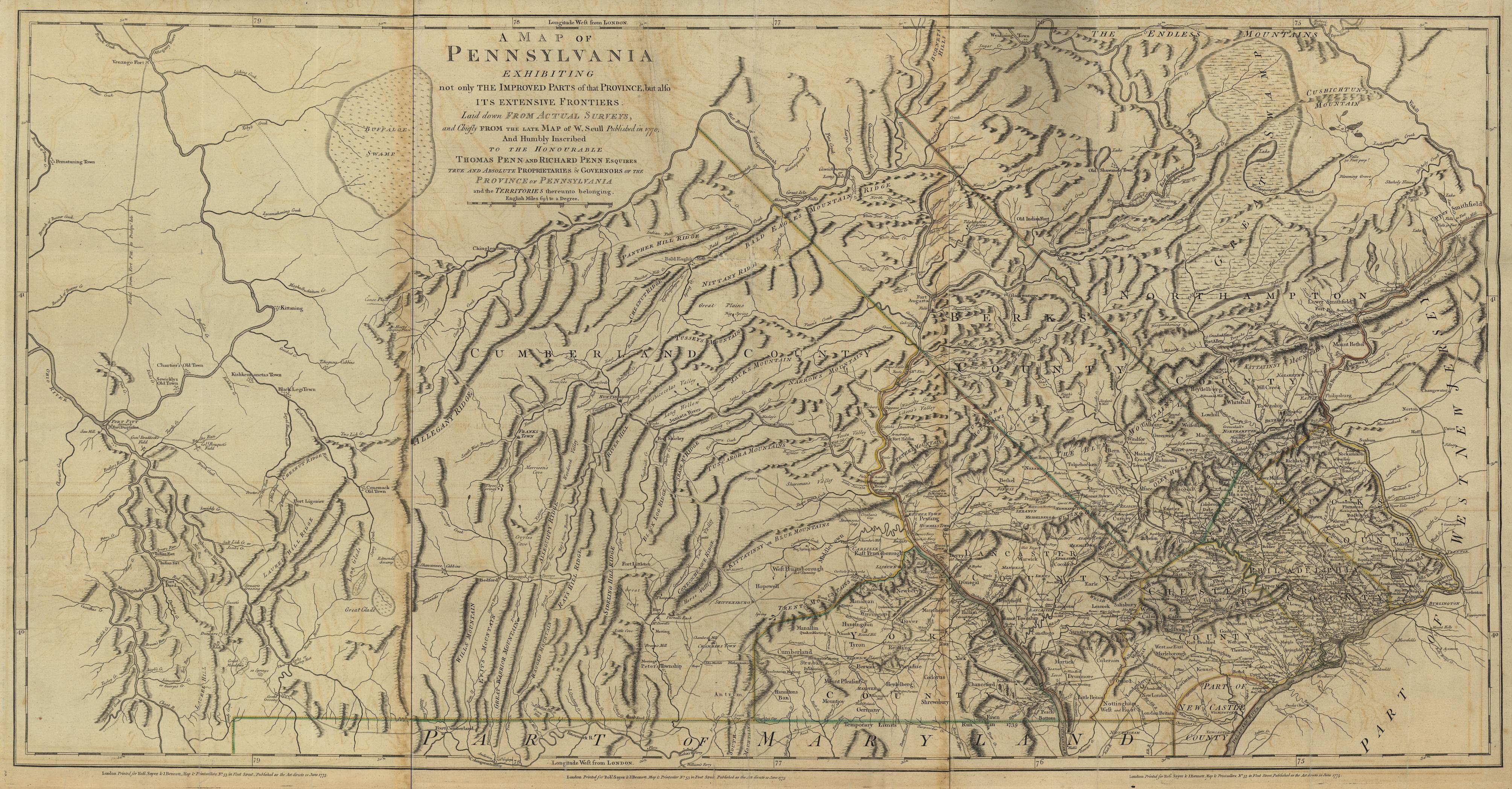

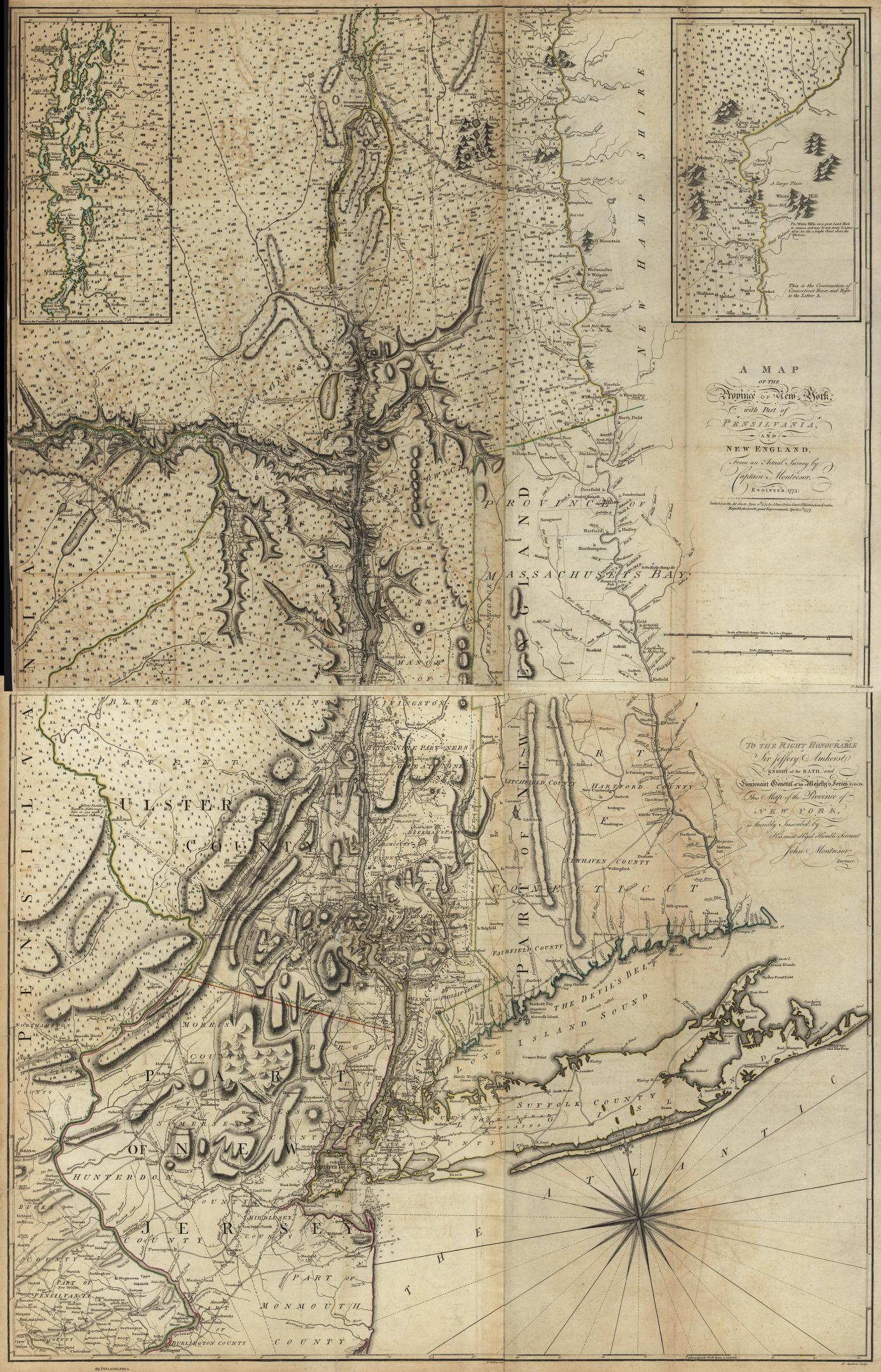
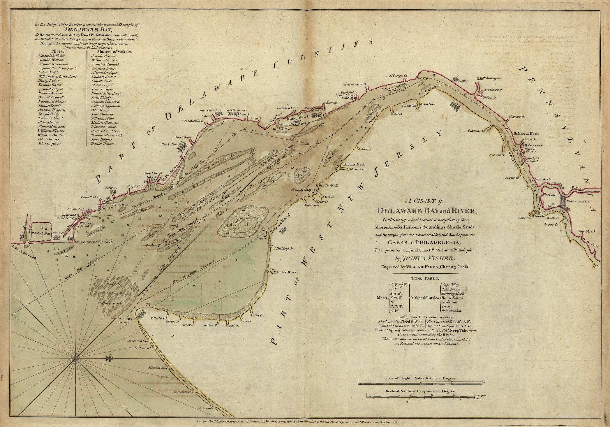

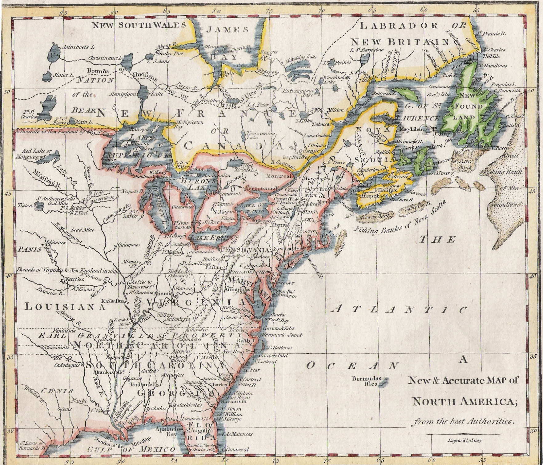


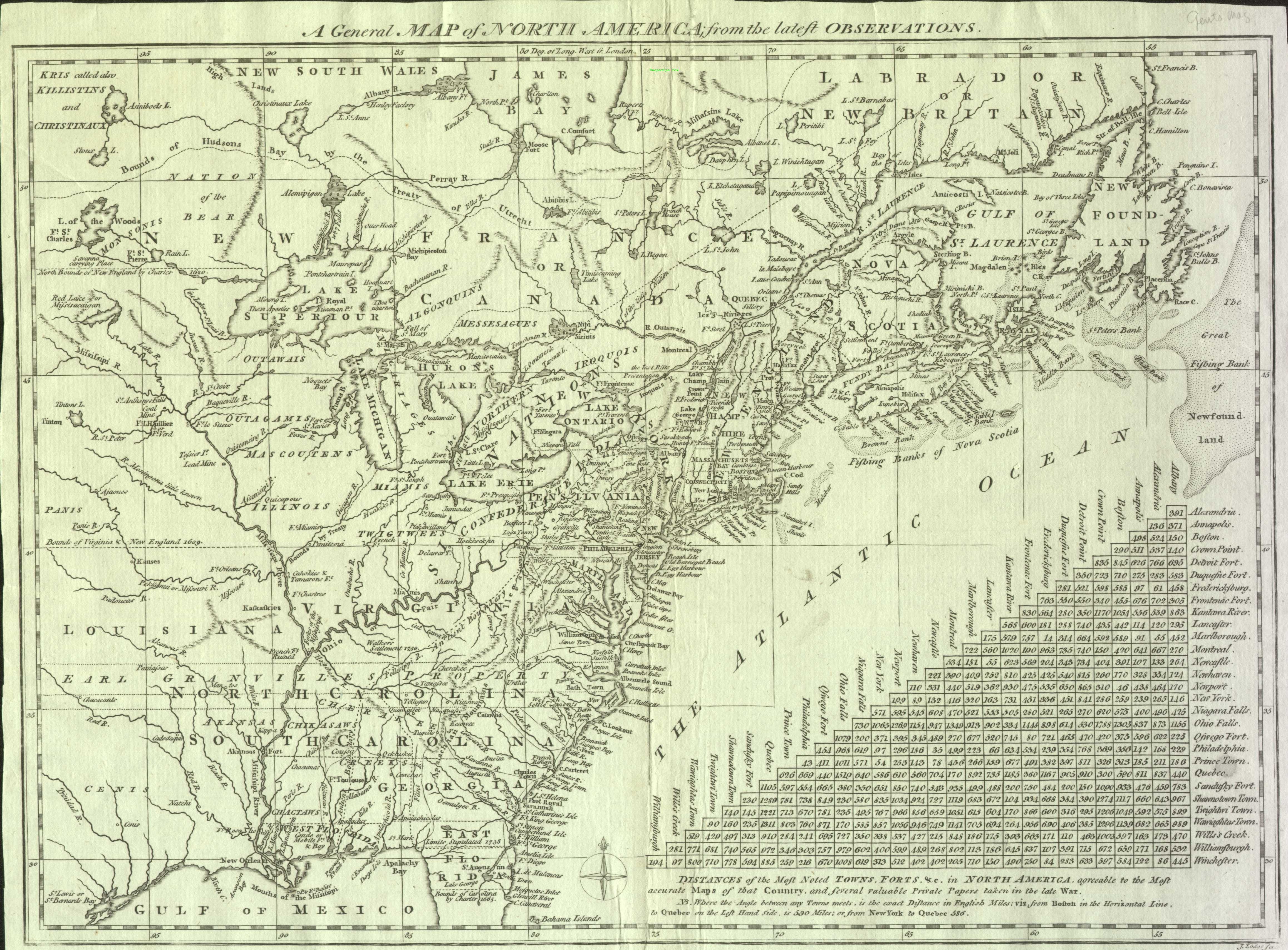


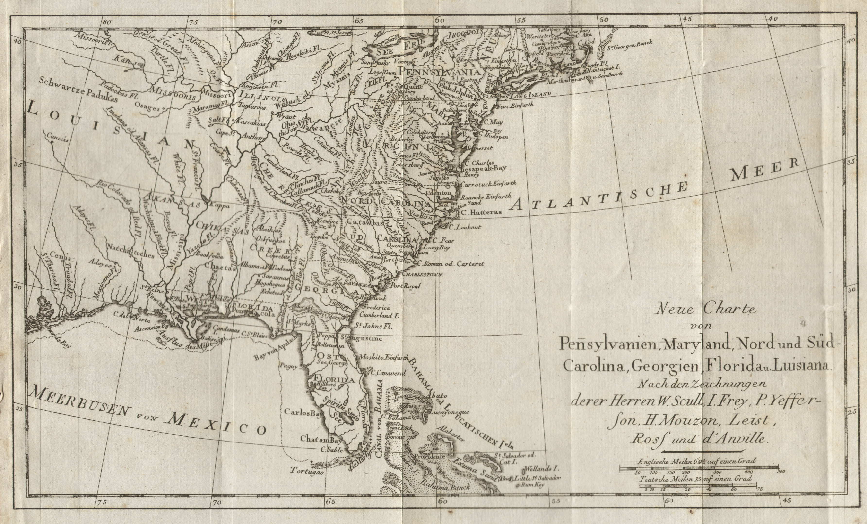

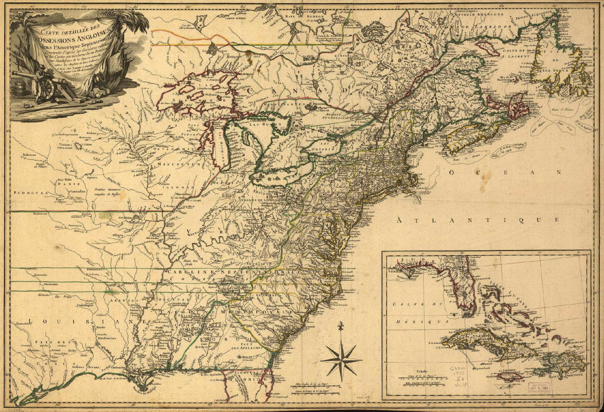


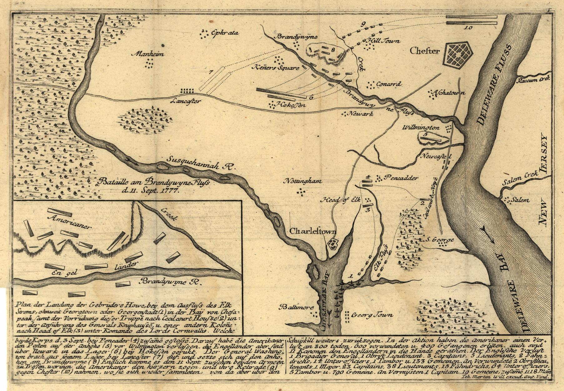

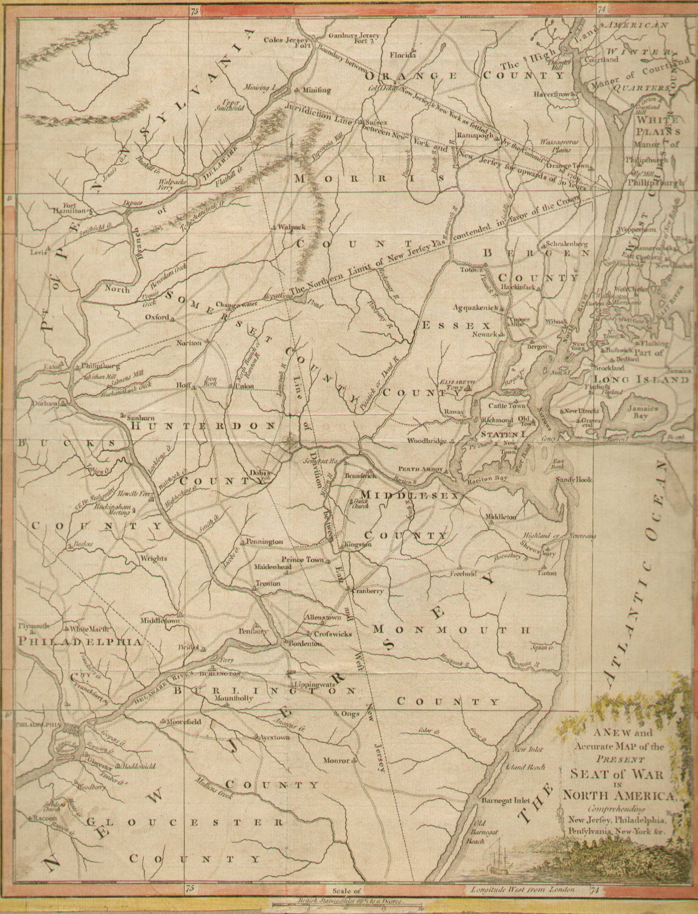
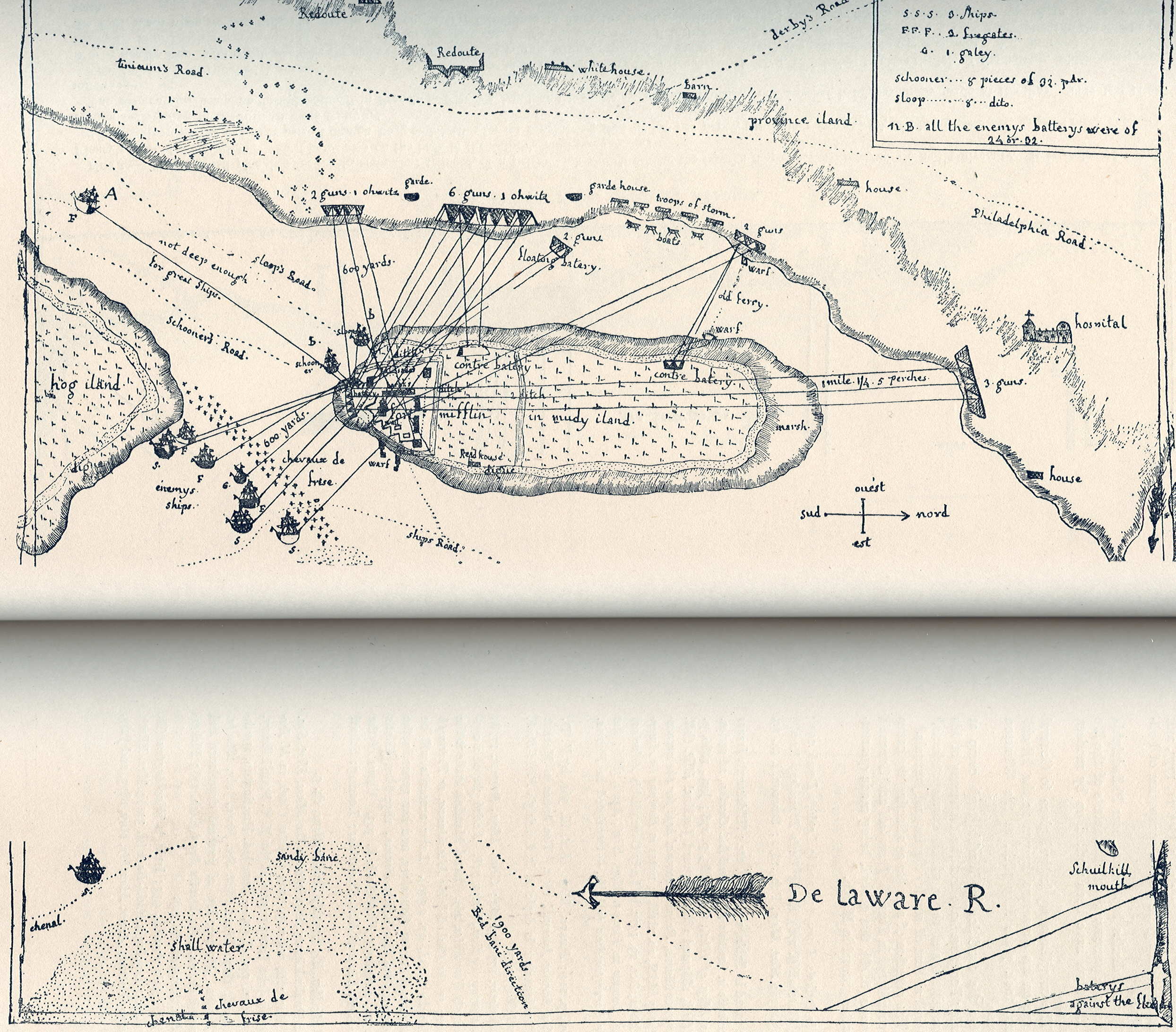
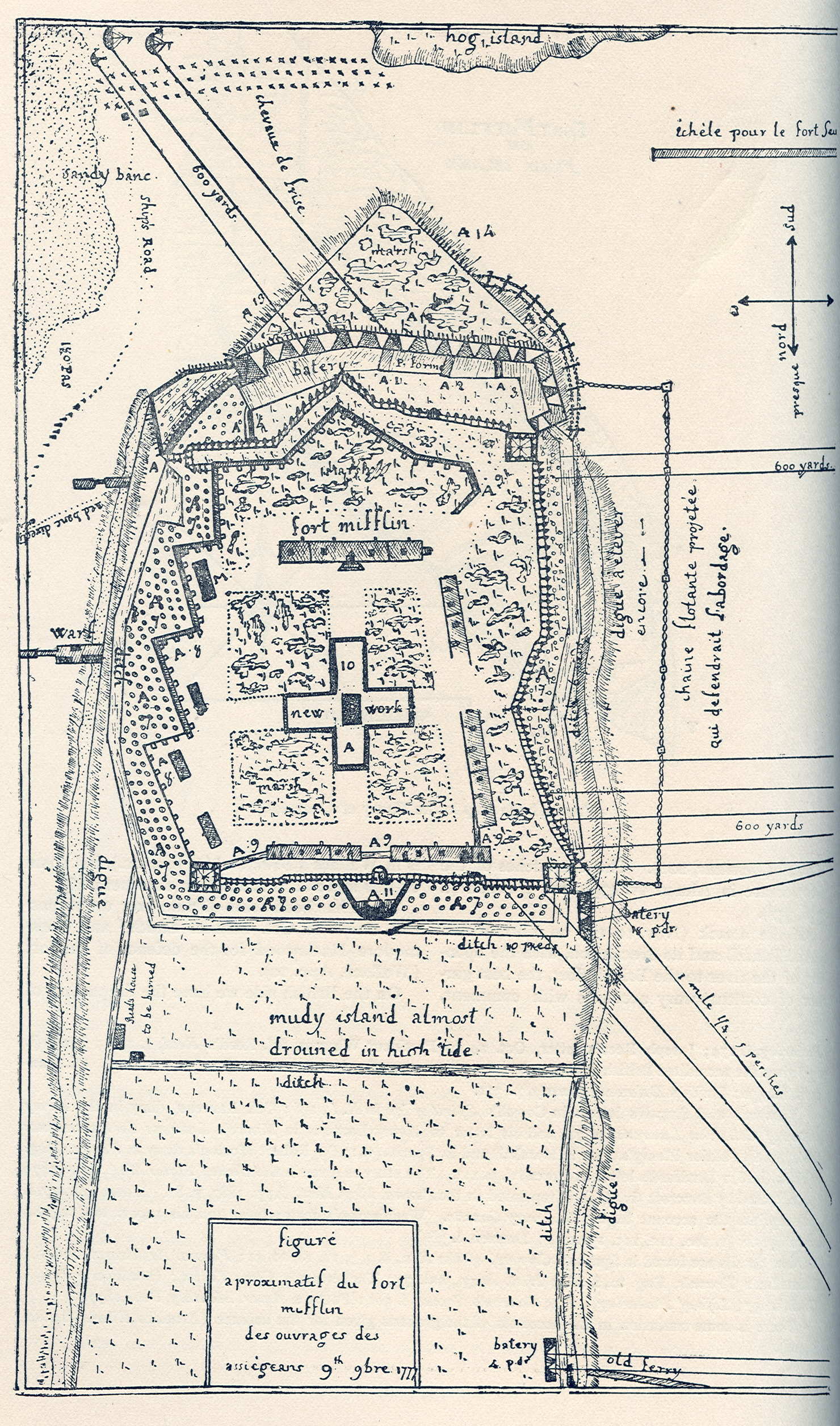
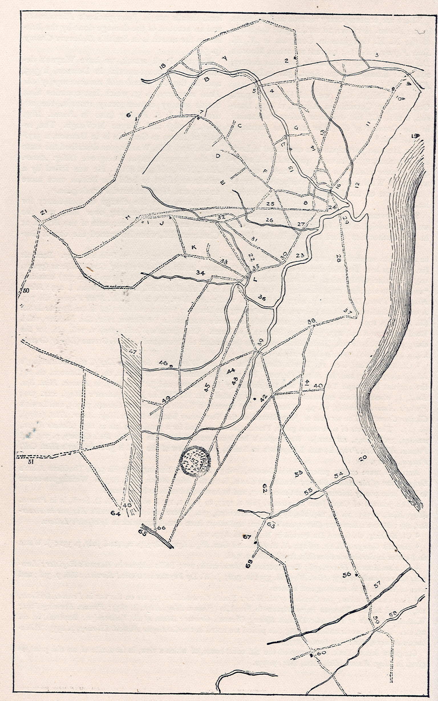
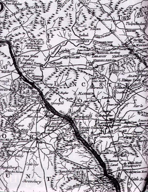
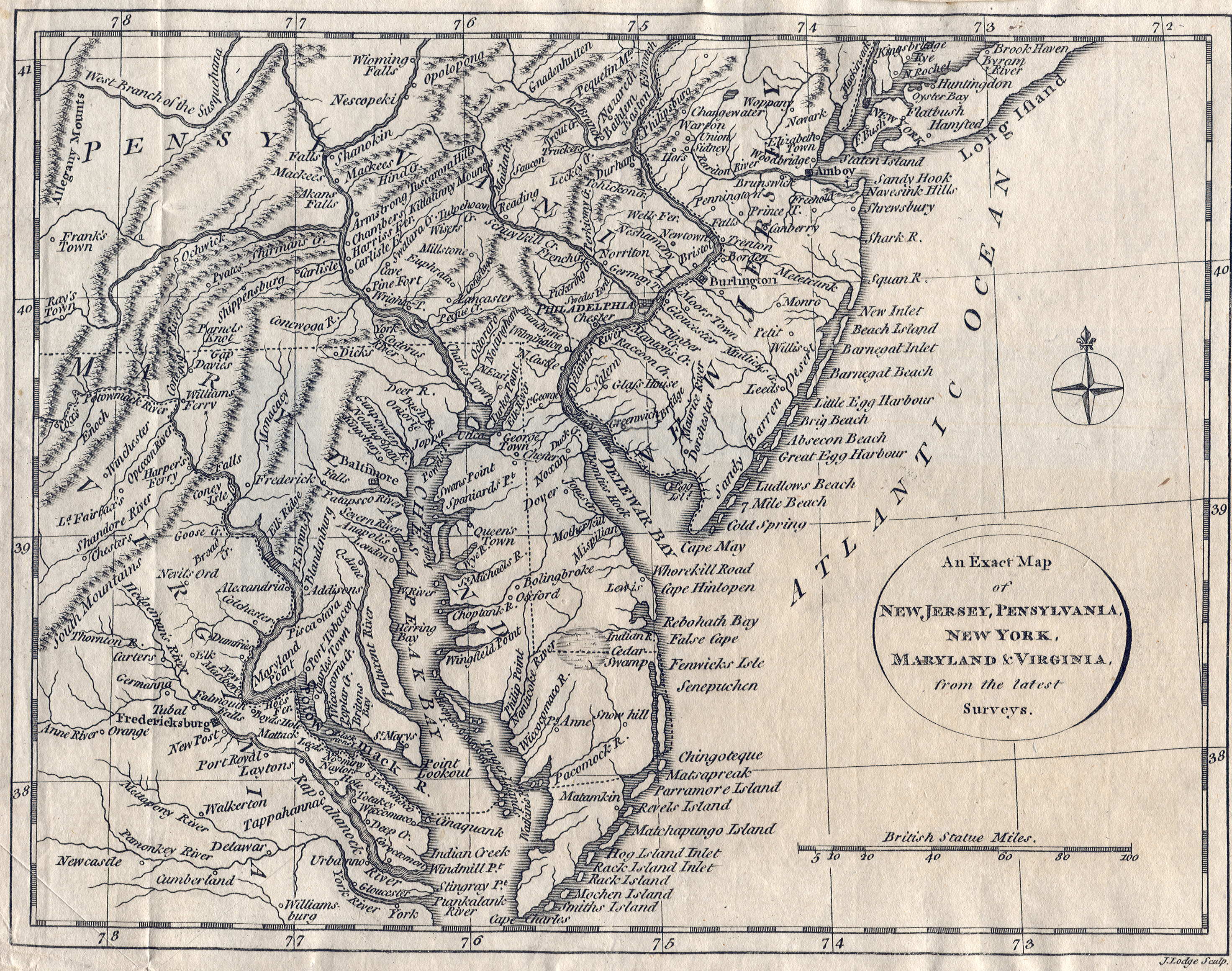
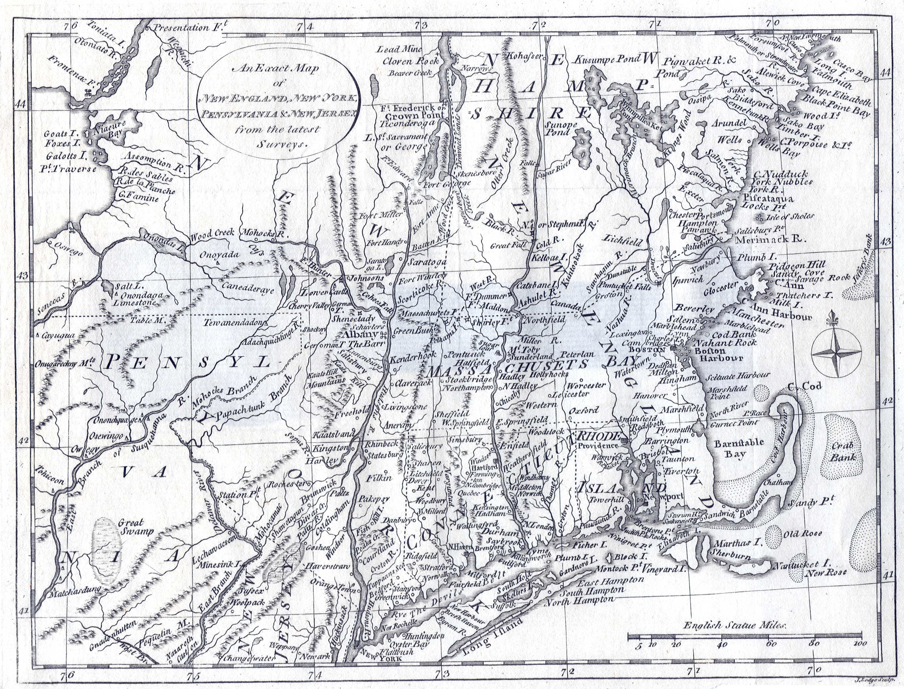
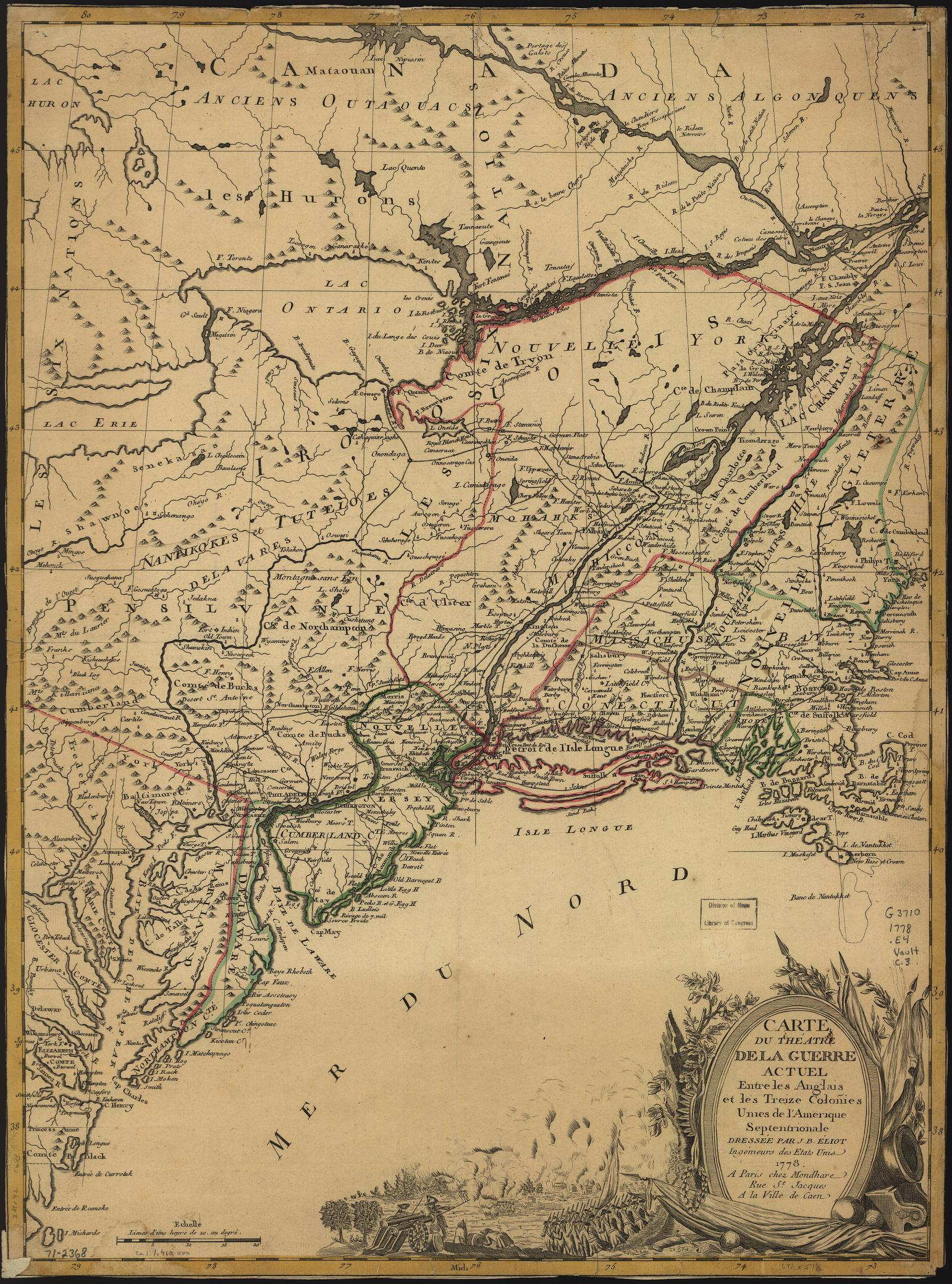
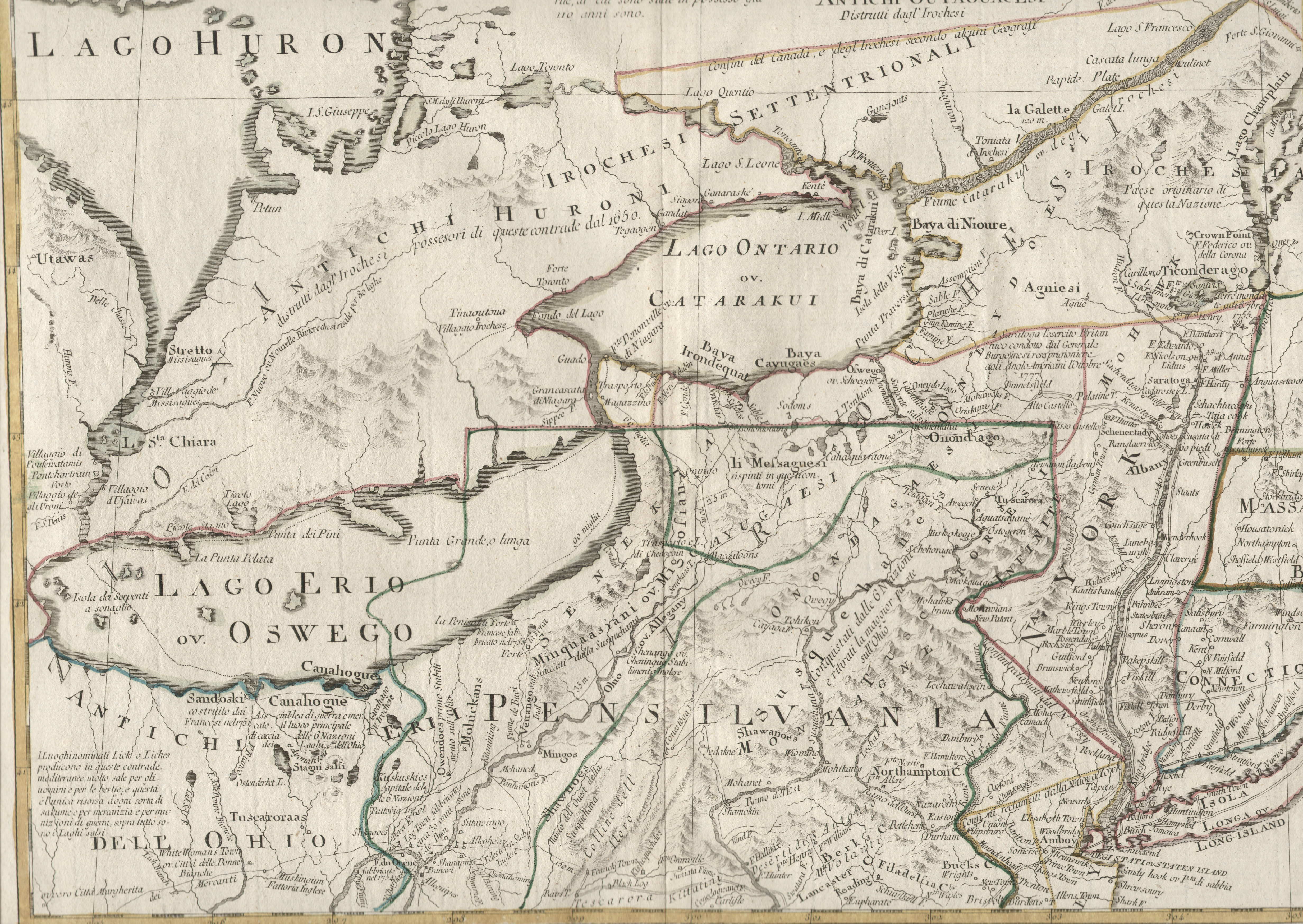
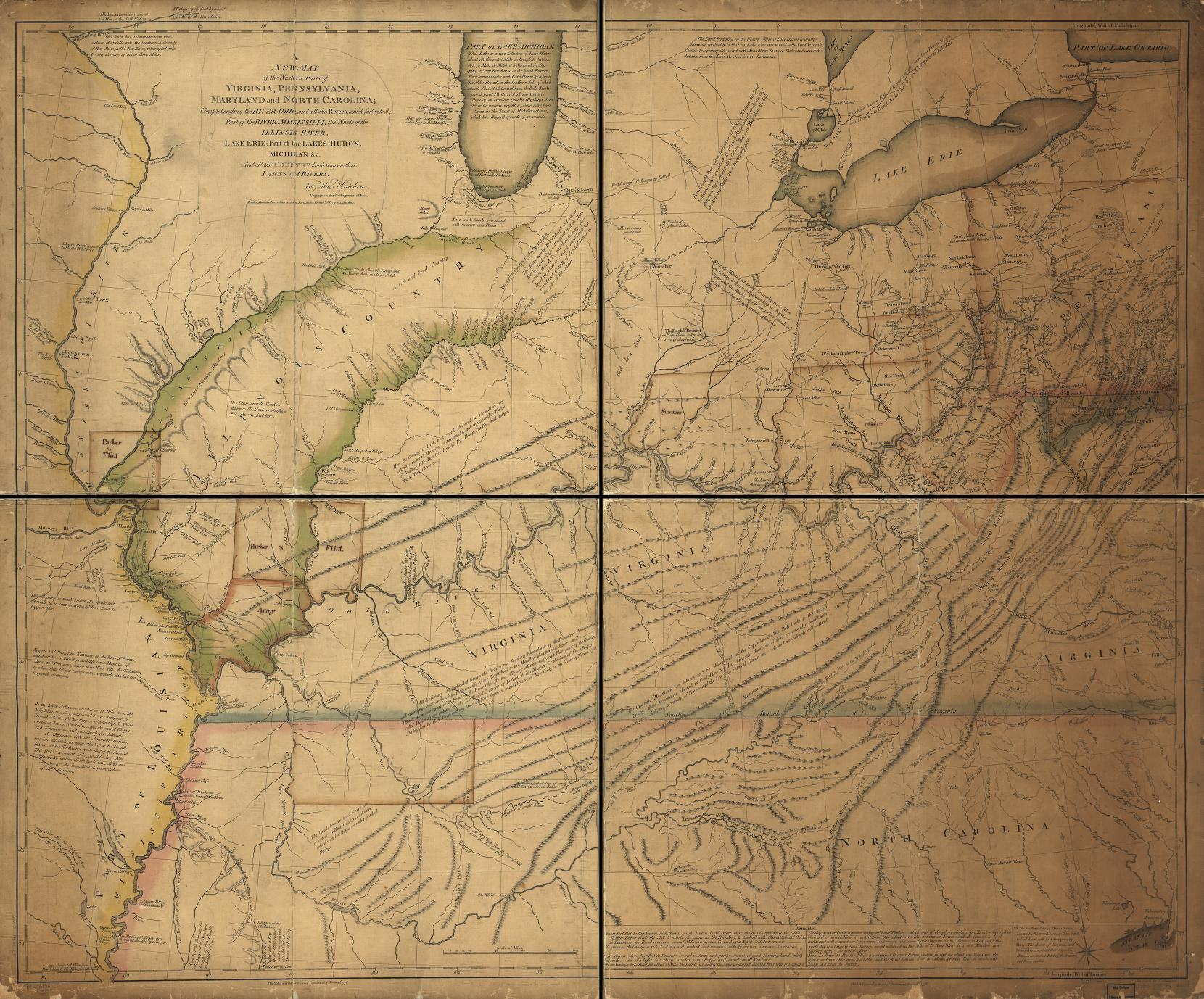
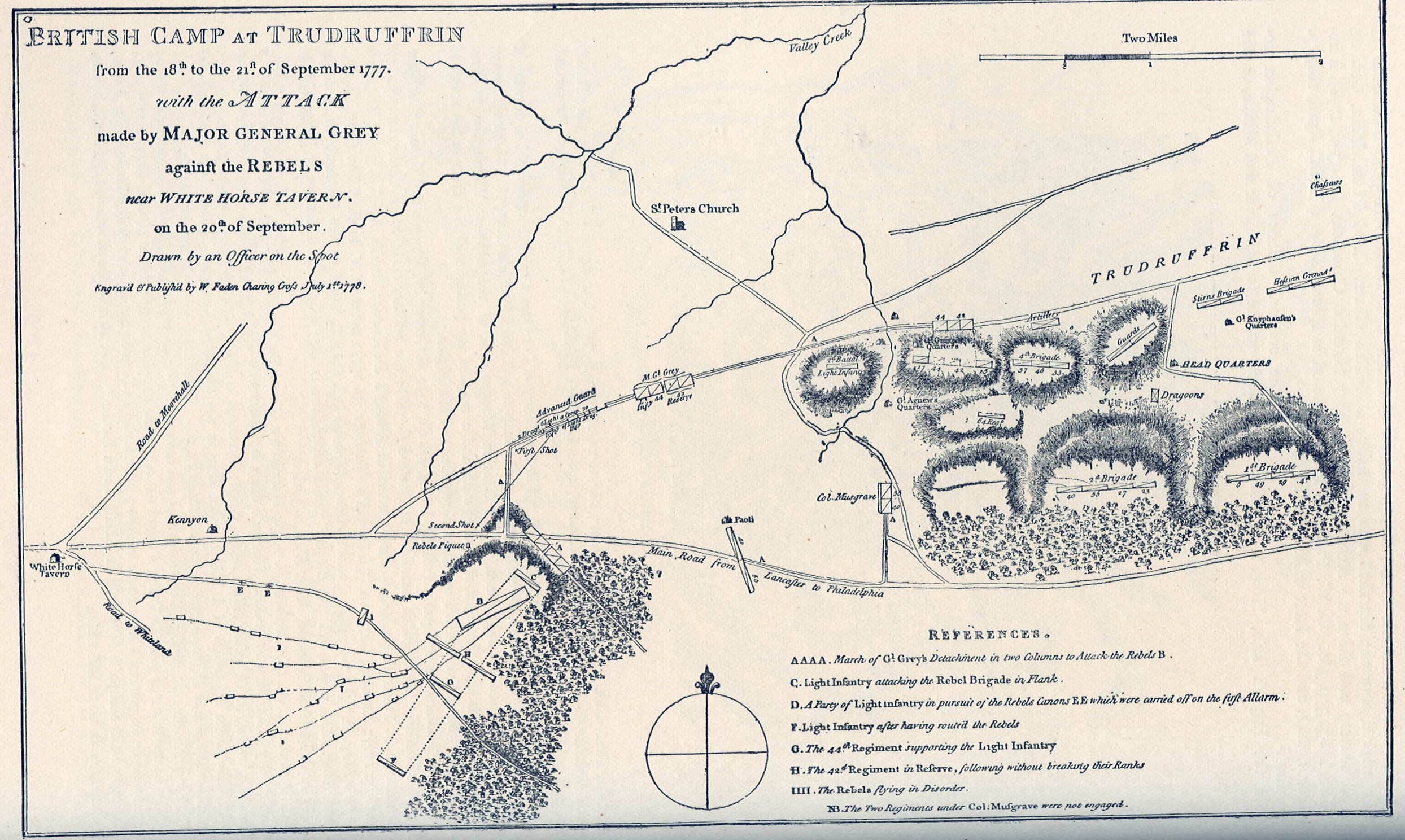
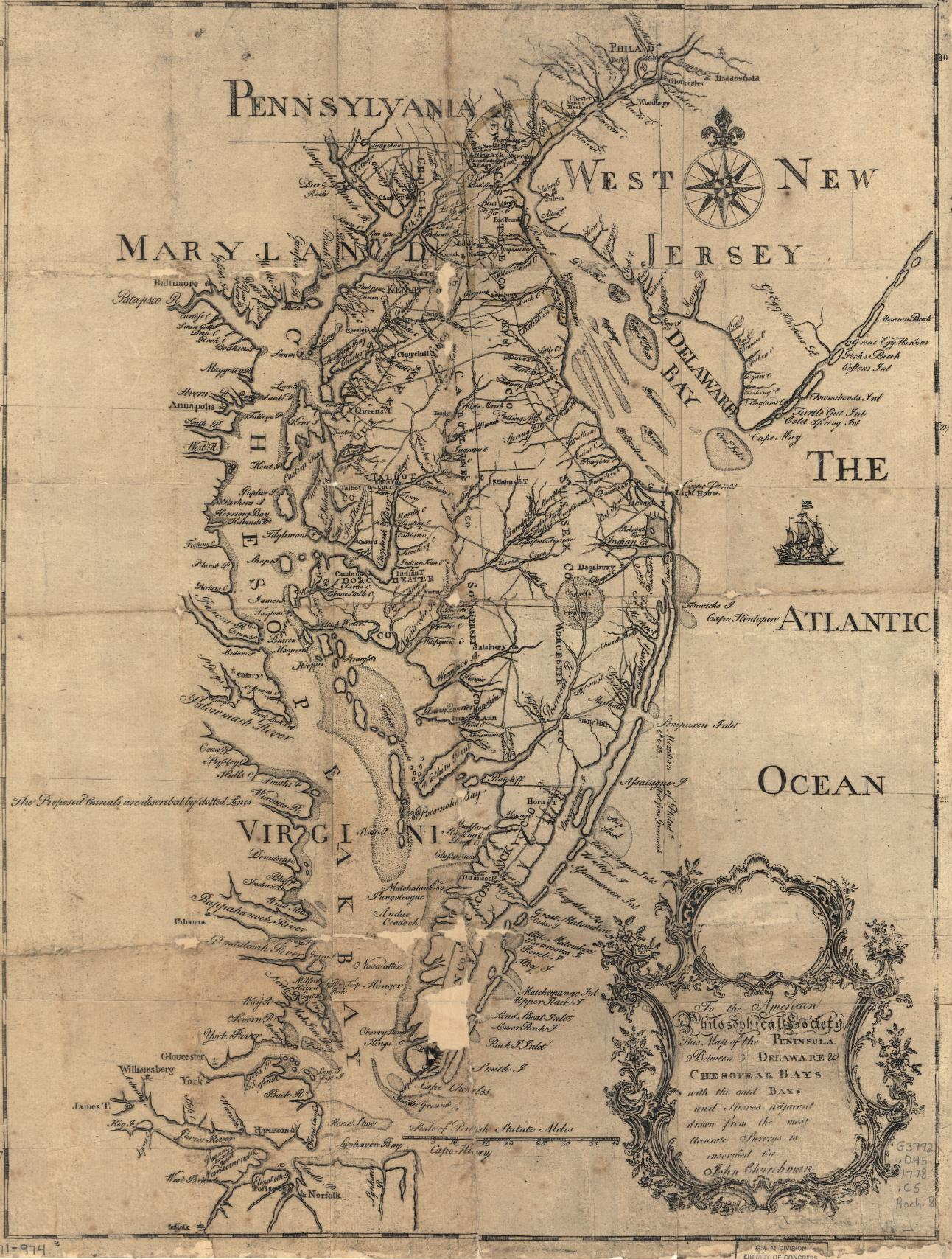
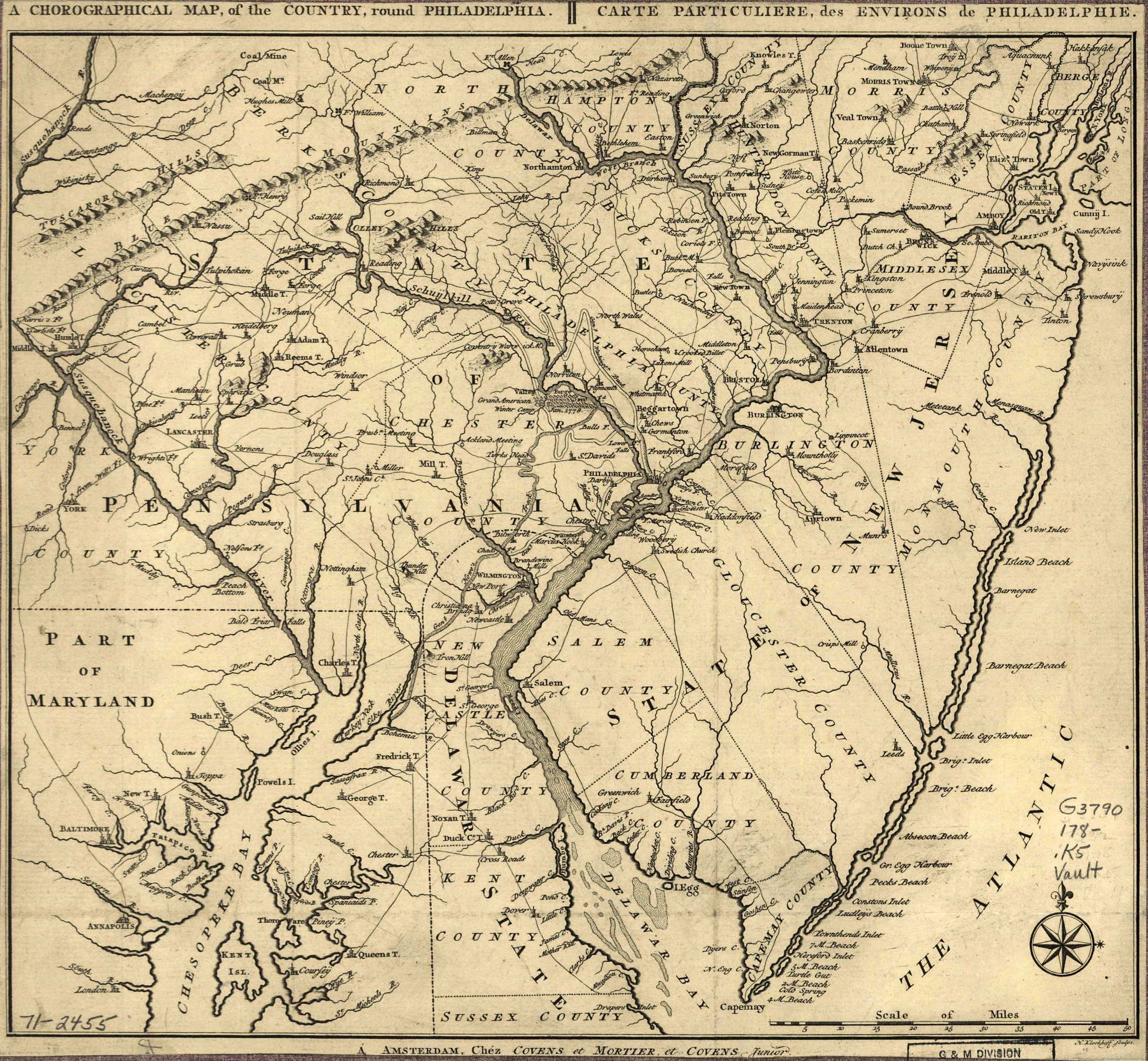
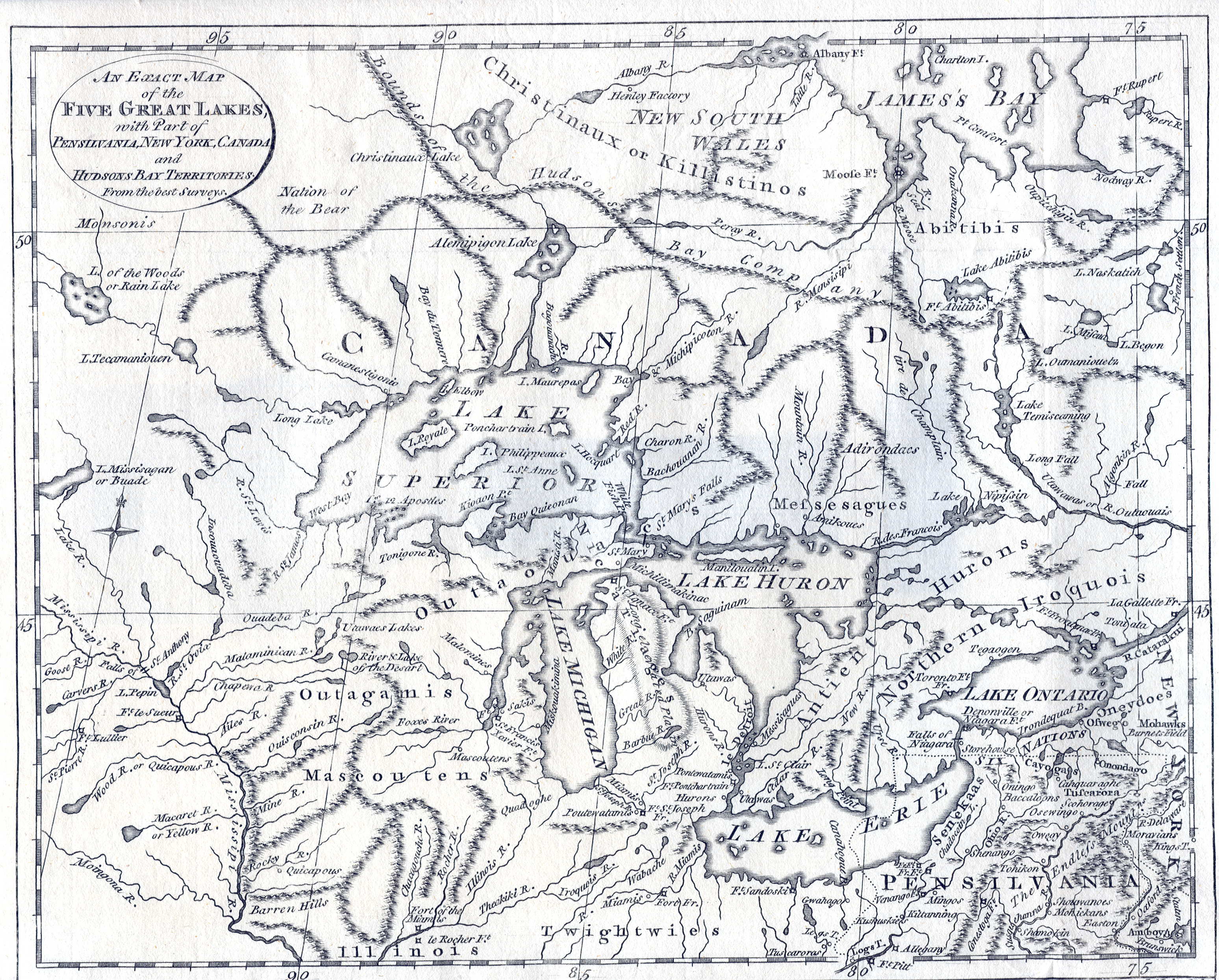
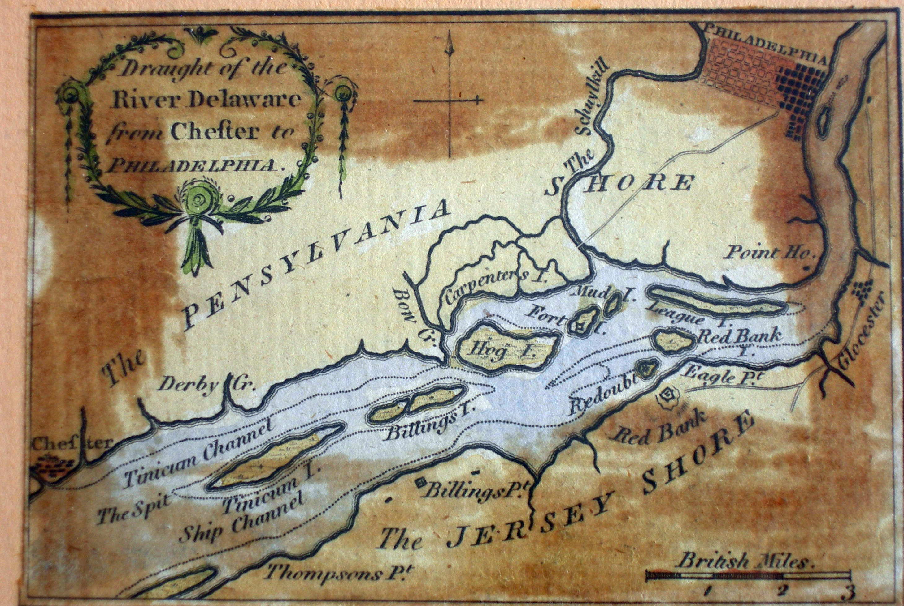
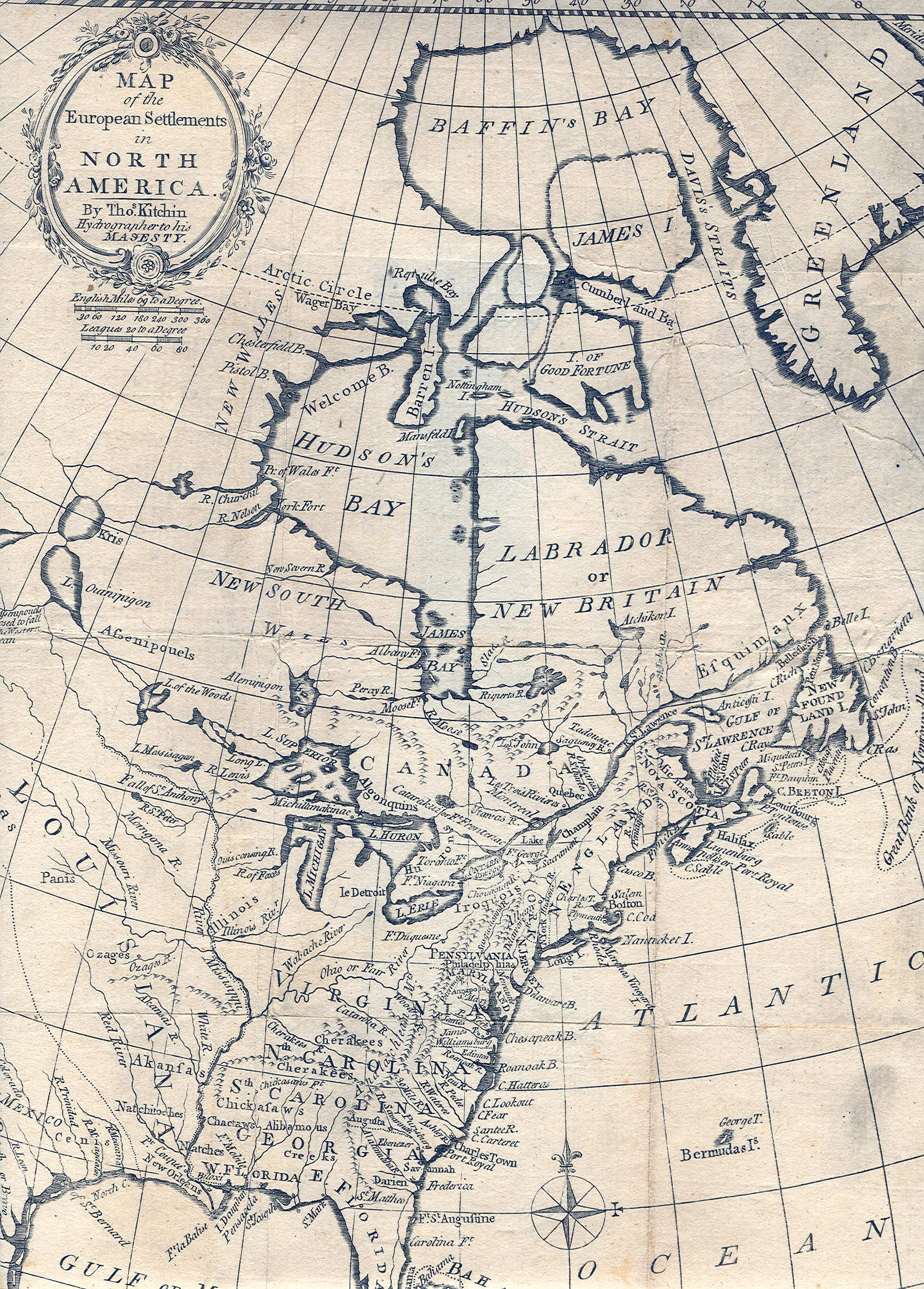
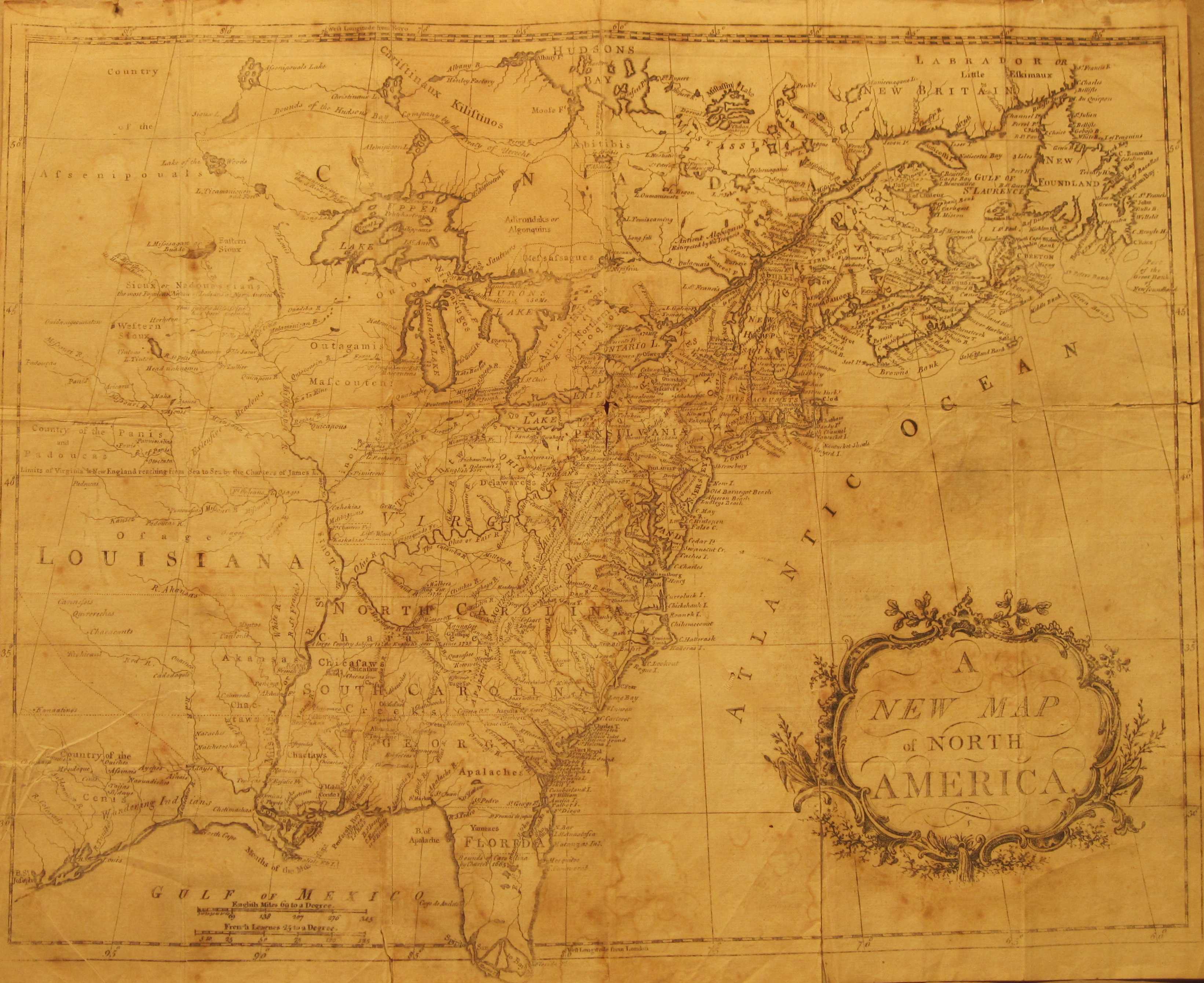
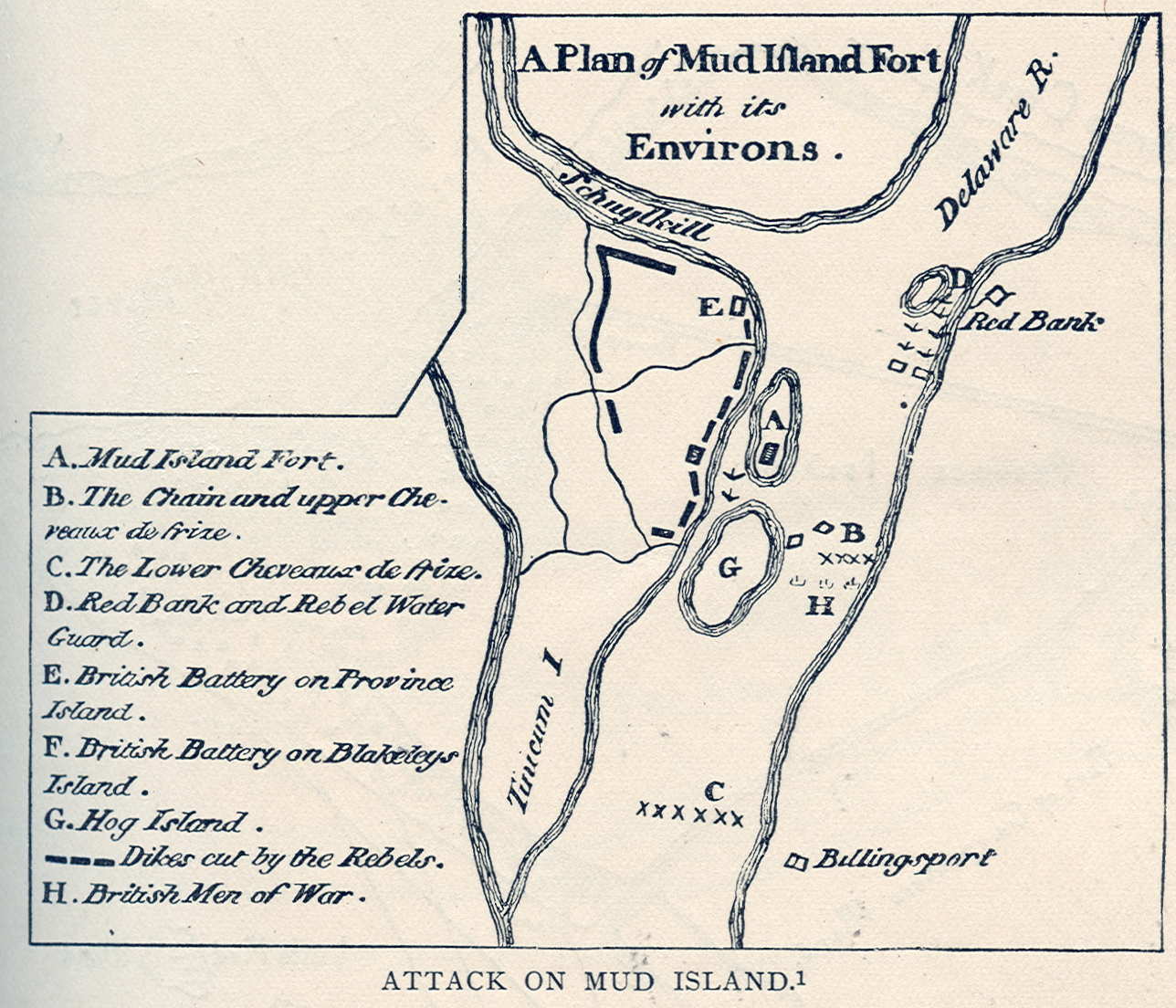