This decade saw the
development of the American map industry with Jedidiah Morse and
Osgood Carleton in Boston and Mathew Carey and Joseph Scott in
Philadelphia. One of the most famous maps of Pennsylvania, the
1792 Reading Howell map, was published in this decade.
Four new counties were
created in this decade: Lycoming County (seat at Williamsport)
and Somerset County (Somerset) in 1795; Green County (Waynesburg)
in 1796; Wayne County (Honesdale) in 1798. As the century ended
there were 25 counties in the state.
 |
1790.1 A
PARTICULAR MAP OF THE AMERICAN LAKES, RIVERS &C. par
le Sr. D'Anville de l'Academie Rle... Drawn and engraved
for John Harrison No. 115 Newgate Street June 25 1790.
According to McCorkle (#790.1), this map is a reduced
version of the original 1755 D'Anville map. Image from
the Heritage Map Museum CD by permission. |
 |
1790.2 CARTE POUR
LE VOYAGE DANS LES PARTIES INTERIEURES DE L'AMERIQUE.
This map is from Voyages dans les parties interieurs
de l'Amerique by Thomas Anburey, Paris 1790, the
French edition of Anburey's 1789 London publication. It
is similar to the 1789 version (map 1789.2) and covers
the region from Maine to Virginia; Pennsylvania is shown
west beyond the Alleghenies up to the river called "R.
de l'Ohio," i.e. the Allegheny River. Vermont is
called "Nouvelle Angleterre." The title is
contained in a rococo-style cartouche. Scale: 1 inch = 65
miles. Size: 11.75 x 9 inches. McCorkle #790.2 |
| |
1790.3 COMPLETE
CHART OF THE COAST OF AMERICA, FROM BRETON INTO THE GULF
OF MEXICO. This atlas of 18 charts was published by
Matthew Clark, Boston 1790. McCorkle (#789.1-4, 790.3)
illustrates ones for New England. |
 |
1790.4 THE UNITED
STATES OF AMERICA, drawn from the Latest Authorities. T.
Conder sculpt. This map of the eastern United States with
a cut off Florida appeared in A New Geographical,
Commercial and Historical Grammer by Alexander
Kincaid, Edinburgh 1790, 92, 99 per McCorkle #790.4.
Pennsylvania is shown with south and east borders, but
not west or north. A few towns are named including
Wyoming, Conestoga, Shamokin, Kittaning, Alleghany,
Shenango. A couple of these may be apocryphal. Longitude
west from Greenwich, blank verso. Scale: 1 inch = 200
miles. Size: 7.75 x 9 inches. |
| |
1790.5 THE PART
OF PENNSYLVANIA THAT LIES BETWEEN THE FORKS OF THE
SUSQUEHANNAH, DIVIDED INTO TOWNSHIPS. This is an
anonymous manuscript map of the land between the east and
west branches of the river north and west of Sunbury. It
is of uncertain date, and dated 179? in Sellers & van
Ee #1299. |
| |
1790.6 A MAP OF
PART OF NORTH AMERICA FROM LAT. 40 TO LAT. 62, Published
...1790 by Dr. John Truster. This map of Canada extends
down to 40 degrees and so includes most of Pennsylvania,
which is named though nothing else is identified. |
| |
1790.7 LA CITA DI
FILADELFIA, Tom 2, pag. 29 Tav. IX, by Benedetto Bordiga,
in Viaggio negli Stati Uniti dell'America
Settentrionale fatto negli anni 1785, 1786, e 1787, da
Luigi Castiglioni Milan 1790. Castiglioni was another
European with an overwhelming desire to publish the
itinerary of his travels. He included this simple grid
map of downtown Philadelphia which he copied from John
Reed's map according to M. P. Snyder, where it is
illustrated in Figure 93. |
 |
1791.1 A MAP
EXHIBITING A GENERAL VIEW OF THE ROADS AND INLAND
NAVIGATION OF PENNSYLVANIA, AND PART OF THE ADJACENT
STATES. Respectfully inscribed to Thomas Mifflin,
Governor, and the General Assembly of the Commonwealth of
Pennsylvania: By John Adlum, and John Wallis. The map
shows settlements, forts, and physical features;
annotated to show additional roads and information about
them; contains inset illustrations of canal locks.
Curiously, Braddock's Road from Cumberland to Pittsburgh
is not shown, although the Forbes Road appears. The image
shown here is a reproduction from the Pennsylvania
Archives, Third Series. Wheat & Brun #432 dated 1791;
Phillips page 679 dated 1792. The Library of Congress has
a large number of manuscript land survey maps prepared by
John Adlum in the William Bingham Estate Map collection.
Bingham owned major land tracts across northern
Pennsylvania; see Docktor
#29_A1, etc. One of those maps
is a reduced copy of this one. |
 |
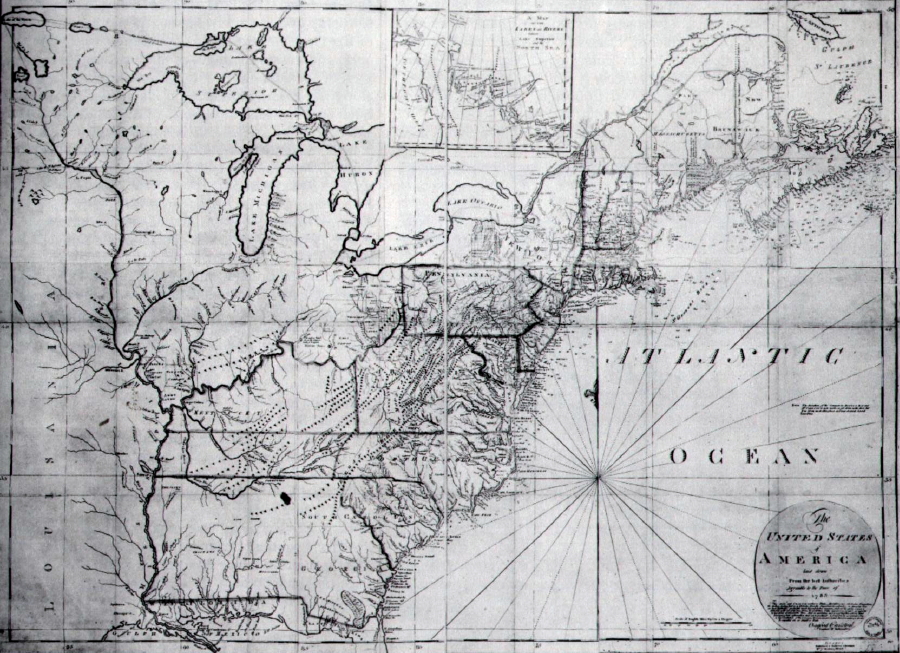
1791.2 THE UNITED
STATES OF AMERICA LAID DOWN FROM THE BEST AUTHORITIES
AGREEABLE TO THE PEACE OF 1783, engraved by John Norman,
published by Osgood Carleton, Boston 1791 (McCorkle #791.1,
Wheat & Brun #119, 138). This map is reproduced in
Schwartz & Ehrenberg, Schwartz (2000), Ristow, and
shown in a Library of Congress print here. Pennsylvania
has its modern northern boundary but without the Erie
triangle which was purchased from New York in 1792. The 'peace
of 1783' refers, of course, to the end of the
Revolutionary War. Size: 32.25 x 45 inches. |
 |
1791.3 A MAP OF
THE UNITED STATES OF AMERICA. Engraved for Morses
Geography. This map is from the third edition of Morse's Geography
Made Easy, Boston 1791, and differs from the map in
the first two editions, map 1784.2. It shows the United
States from Maine to Georgia and west to the Mississippi
with a cutoff Florida. Pennsylvania is shown extended to
about 42d 30m with no western boundary. Georgia, North
Carolina and South Carolina Western boundaries extend to
the Mississippi with most of their Western territory
occupied by Indian tribes: Creek, Choctaw, Chickasaw and
Cherokee. North of Kentucky is shown as Army Lands,
private company tracts, and Indian tribes. McCorkle #791.2,
Wheat & Brun #118. The bottom says 'Longitude
west from London,' but the actual zero meridian is
just east of Philadelphia. Blank verso. Scale: 1 inch =
175 miles. Size: 8.25 x 10 inches. |
| |
1791.4 THE UNITED
STATES OF AMERICA. 1791. London, Published Aug. 1st 1791,
by J. Johnson, St. Paul's Church Yard. This map is from
the Universal Geography by John Payne, London
1791, 96. McCorkle #791.3 |
 |
1791.5 DE
VEREENIGDE STATEN VAN NOORD AMERICA. Te Amsterdam bij W.
Holtrop. This small map is a version of map 1782.10 by
Holtrop though the dating is uncertain, and it is smaller
and cruder. A new plate has been cut and the map
considerably revised although it covers the same
geography; that is, the eastern United States west to the
Mississippi. Pennsylvania extends to the 43rd parallel,
Philadelphia and Lancaster are named and Delaware
included within Pennsylvania's borders. Blank verso,
longitude west from (probably) Paris. Scale: 1 inch = 500
miles. Size: 3.75 x 4.5 inches. |
| |
1791.6 A PLANN OF
THE NEW STATE ROAD PETITIONED FOR BY THE INHABITANTS OF
MILFORD TOWNSHIP BEDFORD & YOHOGENNY ROAD, also
called HARMAN HUSBAND'S WALKING MAP. This manuscript map
is held in Record Group 26 at the Pennsylvania Archives
and reproduced on page 84 in Shirk. It accompanied a
petition to the state for a road over the mountains from
Bedford to Milford Township (now) in Somerset County. |
 |
1792.1 A MAP OF
THE STATE OF PENNSYLVANIA, By Reading Howell, MDCCXCII;
To Thomas Mifflin Governor the Senate, and House of
Representatives of the Commonwealth of Pennsylvania, this
map is respectfully inscribed by the author. This is the
first state (Wheat & Brun No. 433) of what is called
Howell's "large map." The original map was 38 x
64 inches and issued in four printed quadrants in a
succession of states (Wheat & Brun 434-36, 440-41,
453); an overview of it is given in Schwartz (2000). Most
copies of the map are assembled quadrants of various
states, three such copies can be seen at the Darlington Library. Reading Howell's 1792 map was the best one of
Pennsylvania to appear in the eighteenth century. Mathew
Carey used Samuel Lewis' copy of it (map 1795.3) for his
publications and most other publishers from this date on
used the Howell map as a model. Howell issued several
versions, updating it into the early 19th century. The
image here is the northeast quadrant containing the title,
printed circa 1810 since Ontario and Susquehanna County
appear and possibly the last version of the four sheet
map printed. Listed on page 679 of Phillips and discussed
by Garrison, Rosenberger. Longitude from Philadelphia.
Blank verso. Scale: 1 inch = 5 miles. Size: 19 x 32
inches for one quadrant. |
 |
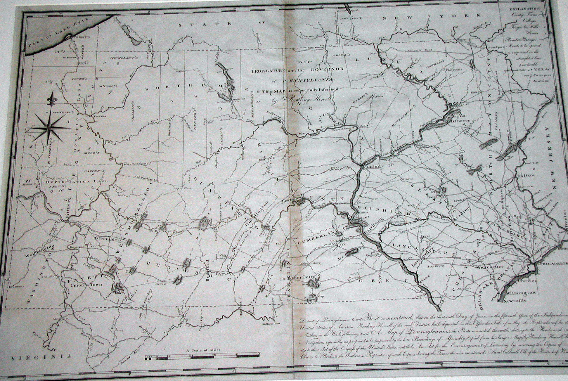
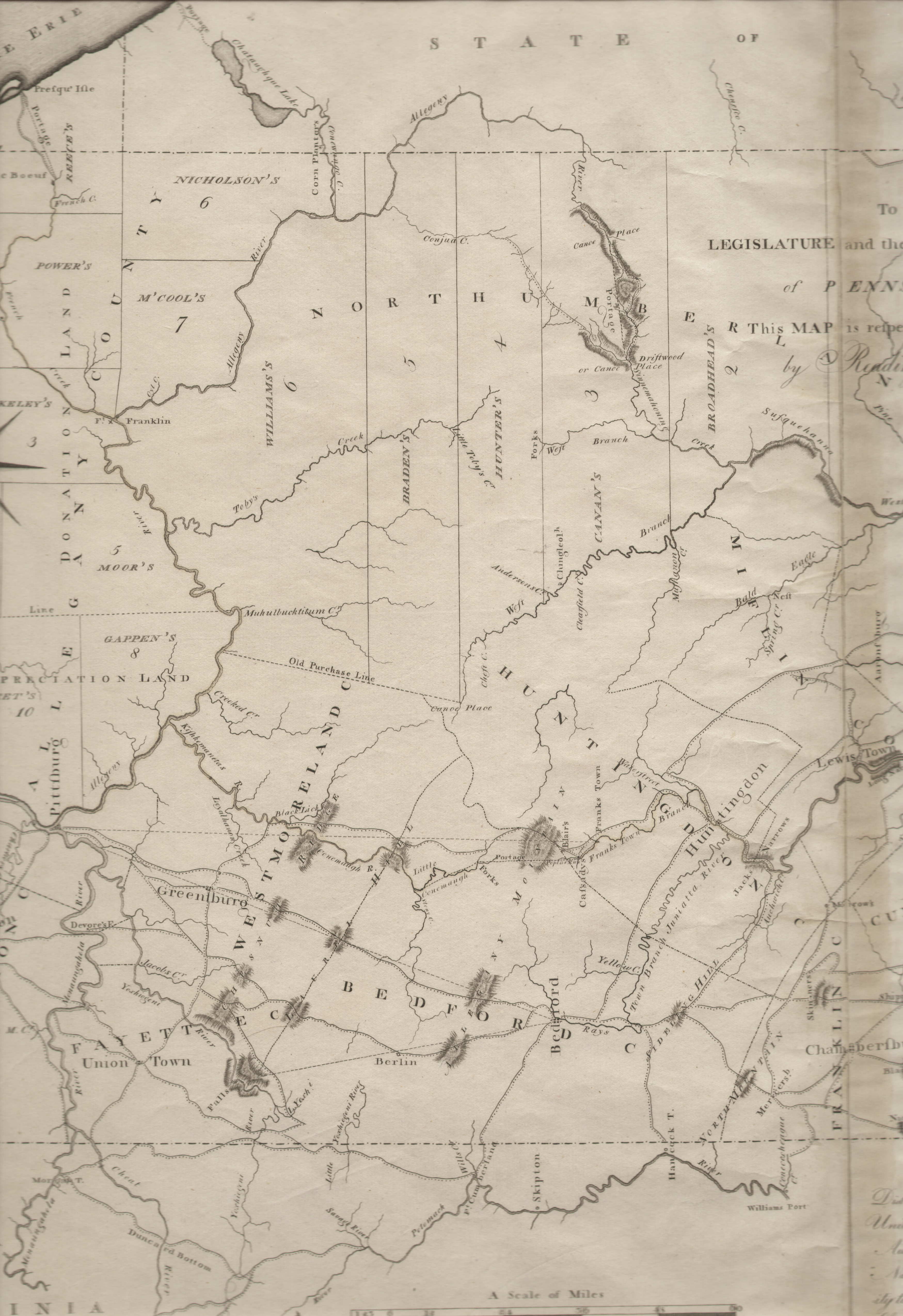
1792.2 DISTRICT
OF PENNSYLVANIA TO WIT: 'IN THE FIFTEENTH YEAR OF
THE INDEPENDENCE OF THE UNITED STATES'.. READING
HOWELL HATH DEPOSITED A MAP OF PENNSYLVANIA, AND THE
PARTS CONNECTED THEREWITH, RELATING TO THE ROADS AND
INLAND NAVIGATION, ESPECIALLY AS PROPOSED TO BE IMPROVED
BY THE LATE PROCEEDINGS OF ASSEMBLY. (Copied from his
larger map) by Reading Howell... Sam'l Caldwell, Clk of
the District of Pennsylvania. Engraving by J. Trenchard.
The dedication is at upper center "to the
Legislature and the Governor of Pennsylvania this map is
respectfully inscribed by Reading Howell." There is
an explanation table at upper right. This is the first
state of Howell's "small map" of 1792 (Wheat
& Brun #437). The image shown here is the state 2
version (Wheat & Brun #443) from the Schuylkill and
Susquehanna Navigation Commission 1795 report An
Historical Account of the Rise, Progress and Present
State of the Canal Navigation. It contains some
additions from the 1792 map, including the naming of all
the counties with their boundaries shown. The emphasis is
on transportation, showing the roads and canals through
the counties and it is the most detailed of Howell's maps
in this respect. Here are closeup views of
east
and
west
sections of this large map.
The third state was issued circa 1796 (Wheat & Brun #447).
Slightly larger versions were made in 1811 and 1817. A
facsimile of this map was printed in 1834 for a US
Congress report. Wheat & Brun #464 list a
Philadelphia map by Howell for which a copyright
reference was found circa 1794 but the map has never been
seen. Longitude from Philadelphia, blank verso. Scale: 1
inch = 12 miles. Size: 18 x 26 inches. |
 |
1792.3 A MAP OF
THE NORTHERN AND MIDDLE STATES; comprehending the Western
Territory and the British Dominions in North America.
This map appeared in English editions of Morse's American
Geography published by John Stockdale, London 1792,
94. It has the same title and closely resembles map 1789.3
from the American editions. There was also a 1792 Dublin
edition with a new plate of the same map, and other
editions in 1795 (McCorkle #792.1,2, 795.4,6). An accompanying map of the southern states was titled "A Map of the States of Virginia, North Carolina, South Carolina and Georgia." The map
shows many land grants in the western territories;
Pennsylvania lacks the Erie triangle. Longitude from
Philadelphia at bottom, west from London at top. Scale: 1
inch = 110 miles. Size: 12 x 15 inches. |
 |
1792.4 A MAP OF
THE UNITED STATES AND PART OF LOUISIANA. Eng. by Wm.
Kneass. McCorkle (#780.7) dates this map to 1780, Sellers
& van Ee (#738) date it 178?; however it must date no
earlier than 1792 because Pennsylvania has its modern
boundaries including the Erie triangle. A copy of this map was found in A Geographical Dictionary of the United States of North America... by Joseph Scott, published in 1805. However, it is possible the map appeared earlier. This image is
from the Library of Congress. |
| |
1792.5 (Philadelphia)
An untitled and anonymous map of thirty-six lots between
Locust and Spruce streets advertised for auction; it
appeared in Dunlap's American Daily Advertiser
in several March 1792 editions. Wheat & Brun #460. |
| |
1792.6 (Philadelphia)
An untitled and anonymous map with various dimensions of
wards, blocks, and streets; it appeared in Some
Account of the City of Philadelphia by Benjamin
Davies. Wheat & Brun #461. |
 |
1792.7 THE UNITED
STATES OF AMERICA. This map comes from the 1792 edition
of the Atlas Minimus originally published in
1758 by Emanuel Bowen with maps by John Gibson. The map
originally titled THE ENGLISH AND FRENCH SETTLEMENTS IN
NTH. AMERICA, map 1758.6, has been renamed; also "New
France" has been removed. Otherwise the map is the
same as the original 1758 version. The other 1792 maps
with Pennsylvania still have the same name as the 1758
maps and are unchanged, and so are not relisted here. Scale: 1 inch = 600 miles. Size: 2.75 x 3.75 inches. |
 |
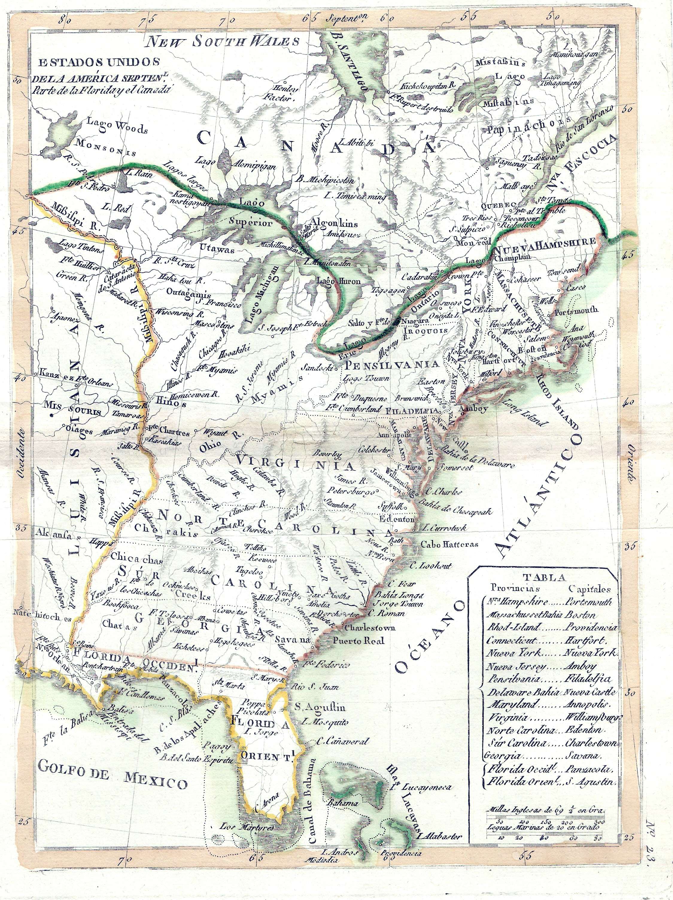
1792.8 ESTADOS
UNIDOS DE LA AMERICA SEPTENL. PARTE DE LA FLORIDAY EL
CANADA. This Spanish map comes from Atlas Elemental
Moderno Colecci n de Mapas, para ense ar los
ni os Geograf a, del cart grafo Tom s L pez, Se
edit en Madrid en 1792. There is also a facsimile
edition published in 2003. It is a copy of map 1783.7 by
Rigobert Bonne. Like that map, it shows the United States
from Maine to Florida and west to the Mississippi.
Pennsylvania's northern boundary extends to 43 degrees;
the western boundary follows the Ohio south to below the
40th parallel. A table at bottom right gives the capitols
of the states. Spanish names are used for physical
features, i.e. lago for lake. Blank verso, with longitude
markings identical to map 1783.7. Scale: 1 inch = 225
miles. Size: 9.5 x 7 inches. |
| |
1792.9
NORTH BOUNDARY OF THE STATE OF PENNSYLVANIA, a small
manuscript map which is a copy of the survey conducted by
Andrew Ellicott for the purchase of the Erie triangle. It
is on a page of the Indian Deed Book in Record Group 26
in the Pennsylvania Archives and reproduced on page 86 in
Shirk. The area shown is the purchased triangle. |
 |
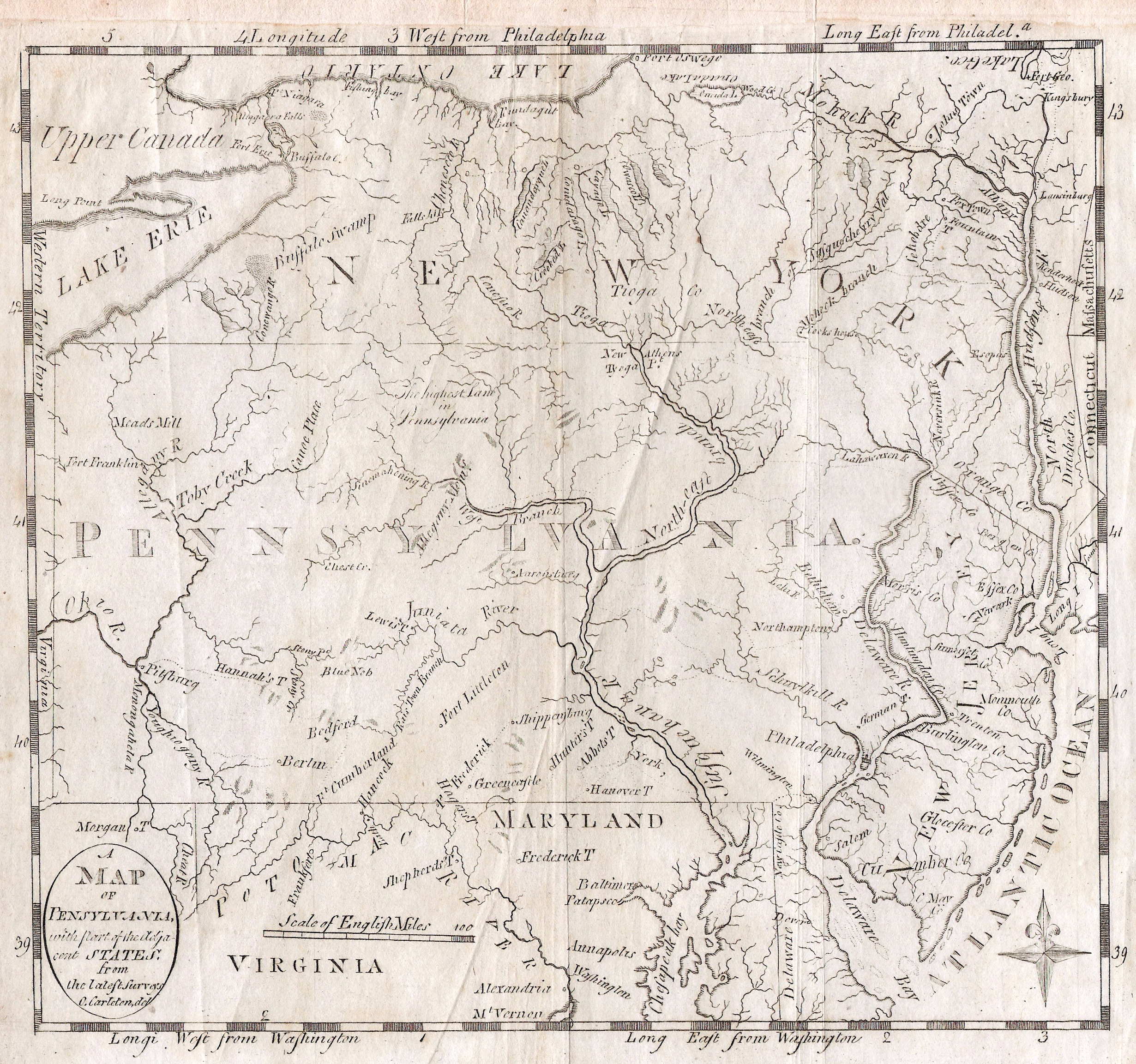
1793.1 A
MAP OF PENSYLVANIA WITH PART OF THE ADJACENT STATES FROM
THE LATEST SURVEYS, O. Carleton, Del. This map was
published in the second edition of The American
Universal Geography by Jedidiah Morse, Boston
1793. The first edition was published in 1789. Samuel F.
B. Morse, the inventor of the telegraph, was the son of
Jedidiah. There is no Erie triangle indicating map
preparation prior to 1792. Delaware is shown separated
from Pennsylvania by a dotted line. Roads are shown in
very light print and there is a compass rose at lower
right. Longitude is measured from Washington at bottom
and Philadelphia at top. Pennsylvania is spelled with two
n's on the map but with one in the title. No. 438 in
Wheat & Brun and on page 679 of Phillips. Blank verso.
Scale: 1 inch = 65 miles. Size 8.5 x 9 inches. |
| |
1793.2 A MAP OF THE
WESTERN PART OF THE TERRITORIES BELONGING TO THE UNITED
STATES. This map is from A topographical description
of the western territory of North America...
originally by John Filson, the second edition (with
considerable additions) by George [i. e. Gilbert] Imlay,
London, printed for J. Debrett, 1793. The map includes
Pennsylvania and a portion is illustrated in
Winsor (1899). The complete map covers the region from New York to Georgia and west to the Mississippi. There were apparently two versions of this map as a 1795 version can be seen at the Darlington Library.
|
| |
1793.3 A NEW AND
ACCURATE MAP OF THE UNITED STATES OF AMERICA, &c.
from the best Authorities by Thomas Brown, Edinburgh.
This undated map was seen at auction dated circa 1790,
and purportedly from the first general atlas published in
Scotland. It includes the Erie triangle (1792) and
appears to postdate the creation of Kentucky (1792) and
predate Tennessee (1796) and Ohio (1803), so it likely
dates 1793-96. The map covers the east coast to the
Mississippi River; the country west of Pennsylvania is
labeled Western Territory. This map is not listed in
McCorkle. Brown was based in Edinburgh and published from
about 1780 to after 1800; he published an atlas of
Scotland. |
| |
1793.4 DIE
VEREINIGTEN STAATEN VON NOORD-AMERIKA by Johannes Walch,
Augsburg. This is another undated map seen at auction
dated circa 1790s. It names Kentucky (1792) but not
Tennessee, so likely dates 1793-96. The map shows the
east from Nova Scotia to a cutoff Florida and west to the
Mississippi, with the western territories labeled "Indiana".
This map is not listed in McCorkle. Most references for
Johannes Walch in catalogs are after 1800, so this map
may have been published later than its apparent
preparation. |
| |
1793.5 A MAP OF THE ROUTE FROM PHILADELPHIA TO THE INDIAN-TREATY OF 1793 TO BE HELD ON OR NEAR THE MIAMI RIVER. A manuscript map from the collections of the University of Pennsylvania where it is described. The date on the map title is used but it likely dates somewhat later. Parts of it appear copied from other maps of the times. |
| |
1794.1 A MAP OF
THE STATE OF PENNSYLVANIA FROM MR. HOWELL'S LARGE MAP, J.
T. Scott sculp; Engraved for Carey's American edition of
Guthrie's Geography Improved. The Erie triangle is not
shown. Wheat & Brun #439. |
 |
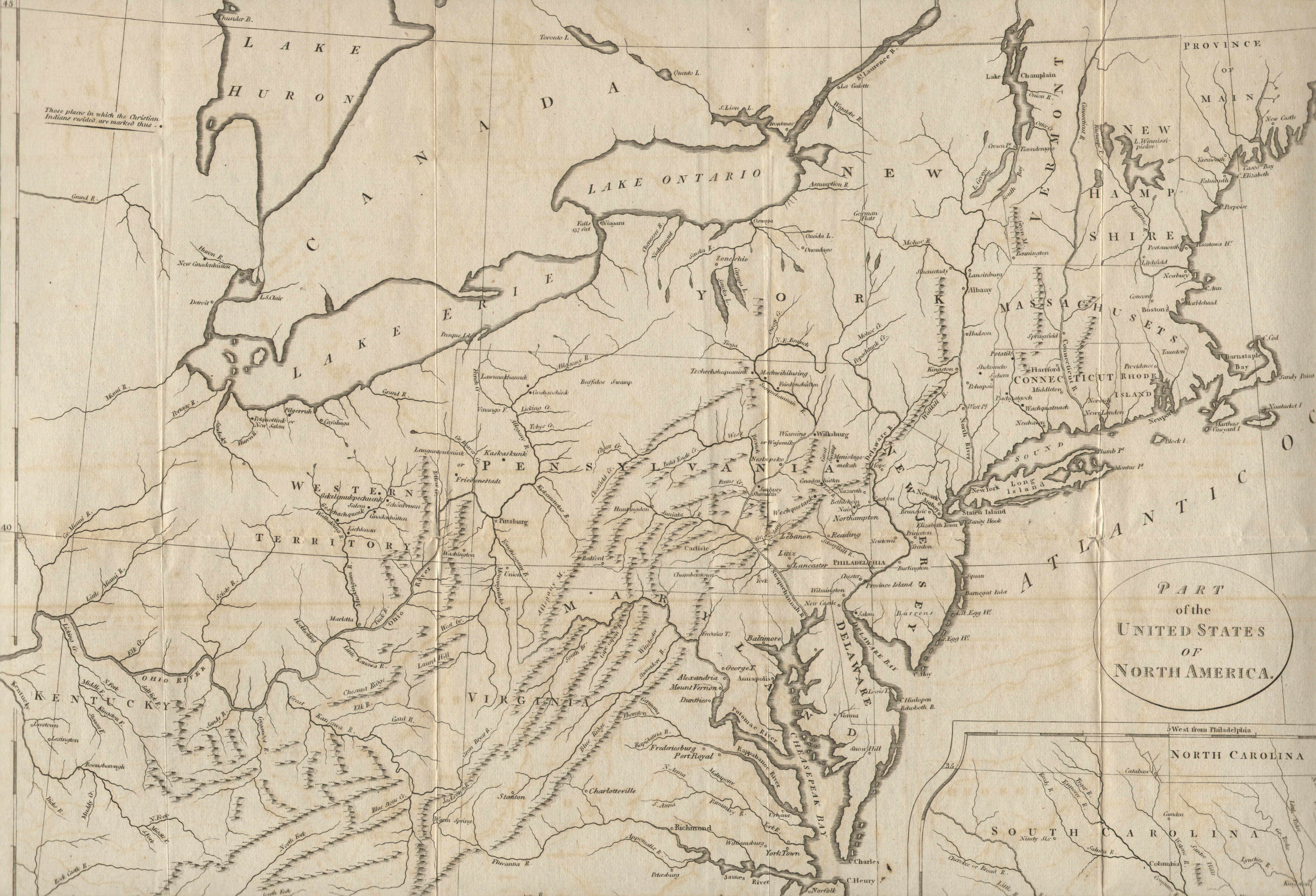
1794.2 PART OF
THE UNITED STATES OF NORTH AMERICA, from History of
the Mission of the United Brethren among the Indians of
North America by G. H. Loskiel, London 1794 (see page
870 of Phillips). Loskiel was German and the book was an
English translation by C. I. Latrobe, printed and sold by
John Stockdale (see Vail). The German title was Geschichte
der Mission Der Evangelisten Bruder Unter Den Indianern
In Nordamkerika, Barby and Lepizig 1789. The German
edition was issued without a map, but the English edition,
printed For The Brethren's Society For The Furthering Of
The Gospel, contained this map. Stockdale made a later
printing in 1798, see Phillips page 872. A map of similar
title was published in Travels Through the States of
North America by Isaac Weld (McCorkle #798.5). The
map shows the east coast from Maine to Carolina with an
inset of the Carolina coast, most of the map can be seen
in this image. Longitude from Philadelphia at bottom,
west from London at top. Originally folded, blank verso.
Scale: 1 inch = 50 miles. Size: 16 x 18.25 inches. |
 |
1794.3 A MAP OF
THE UNITED STATES OF AMERICA, with part of the adjoining
provinces from the latest authorities. T Conder Sculpt.
London. Published June 2d. 1794 by R. Wilkinson, No. 58
Cornhill. In this map of the eastern United States with a
cut off Florida, Pennsylvania is shown with its modern
boundaries. The map appeared in Wilkinson's General
Atlas 1795. This image is from the Library of
Congress where the map is dated 1791 apparently because
of the indistinct dating at the bottom. McCorkle #794.3 |
| |
1794.4 A MAP OF
THE UNITED STATES OF AMERICA. A Doolittle sc. N. Haven
Published by Thomas & Andrews Boston. Engraved for
the abridgement of Morse's America Universal Geography.
The map actually appeared in later editions of Morse's Geography
Made Easy. Pennsylvania extends north to the 43rd
parallel with no western boundary shown. McCorkle #794.4;
Wheat & Brun #122. |
| |
1794.5 A NEW MAP
OF THE UNITED STATES OF NTH. AMERICA, drawn from the
latest authorities by Thos. Kitchin geogr. hydrographer
to his Majesty. Engraved for Baldwyn's New System of
Universal Geography. The map is in A New, Royal,
Authentic...System of Geography by George Baldwin,
London circa 1794. McCorkle #794.10 |
 |
1794.6 AN
ACCURATE MAP OF THE UNITED STATES OF AMERICA. according
to the Treaty of Peace of 1783. Russell del. et sculp
London. Published as the Act directs Oct 18, 1794 by H. D.
Symonds No. 20 Pater Noster Row. The map appeared in Historical,
Geographical...View of the American United States by
William Winterbotham, London 1796, and also in Russell's American
Atlas. It shows the country from Maine to a cut off
Florida and west to the Mississippi, only the northeast
is shown in this image. Pennsylvania has its modern
boundaries sans the Erie triangle, with many rivers and
towns named. The same map also appeared in a new edition of Winterbotham published in 1819. McCorkle #794.14. Longitude west from London,
blank verso. Scale: 1 inch = 103 miles. Size: 14 x 17.5
inches. |
 |
1794.7 TO THOMAS
MIFFLIN, GOVERNOR... THIS PLAN OF THE CITY AND SUBURBS OF
PHILADELPHIA is respectfully inscribed by the editor,
1794. A. P. Folie del. R. Scot & S. Allardice
sculpsit. This is a detailed plan of the city which
appeared in Some Account of the City of Philadelphia
by Benjamin Davies. This image is from a poor modern
reproduction. Wheat & Brun #462, Phillips page 701,
illustrated in M. P. Snyder, Figure 106. |
| |
1794.8 PLAN OF
THE CITY OF PHILADELPHIA. This map was published in James
Hardie, Philadelphia Directory and Register.
There was a 1796 version published in Stephen's
Philadelphia Directory, for 1796 by Thomas Stevens.
Wheat & Brun #463, 467. |
| |
1794.9 (New York,
New Jersey, Pennsylvania) Wheat & Brun #309 describe
a topographical index map, dated circa 1794, of several
sections covering parts of New York and New Jersey, and
northeast Pennsylvania. It was published in The
Geographical Ledger and Systematized Atlas by
Christopher Colles. |
| |
1794.10 A MAP OF
PENNSYLVANIA FROM THE BEST AUTHORITIES, Published 15th
July 1794 by J. Stockdale, Piccadilly. W. Harrison, Junr.
sc. This map is attributed to the English edition of
Jedidiah Morse's The American Gazetteer, Simonetti
#654. A copy seen at auction was attributed to Morse's American
Geography; so perhaps it appeared in both. |
 |
1794.11 A MAP OF
THE MIDDLE STATES OF AMERICA, Drawn from the latest and
best Authorities; by Thos Conder. Engraved for Cooper's
Information concerning America. London, Published Augt.
12th 1794, by J. Johnson, St. Pauls Church Yard.
Simonetti #298, shown here in a photo. |
 |
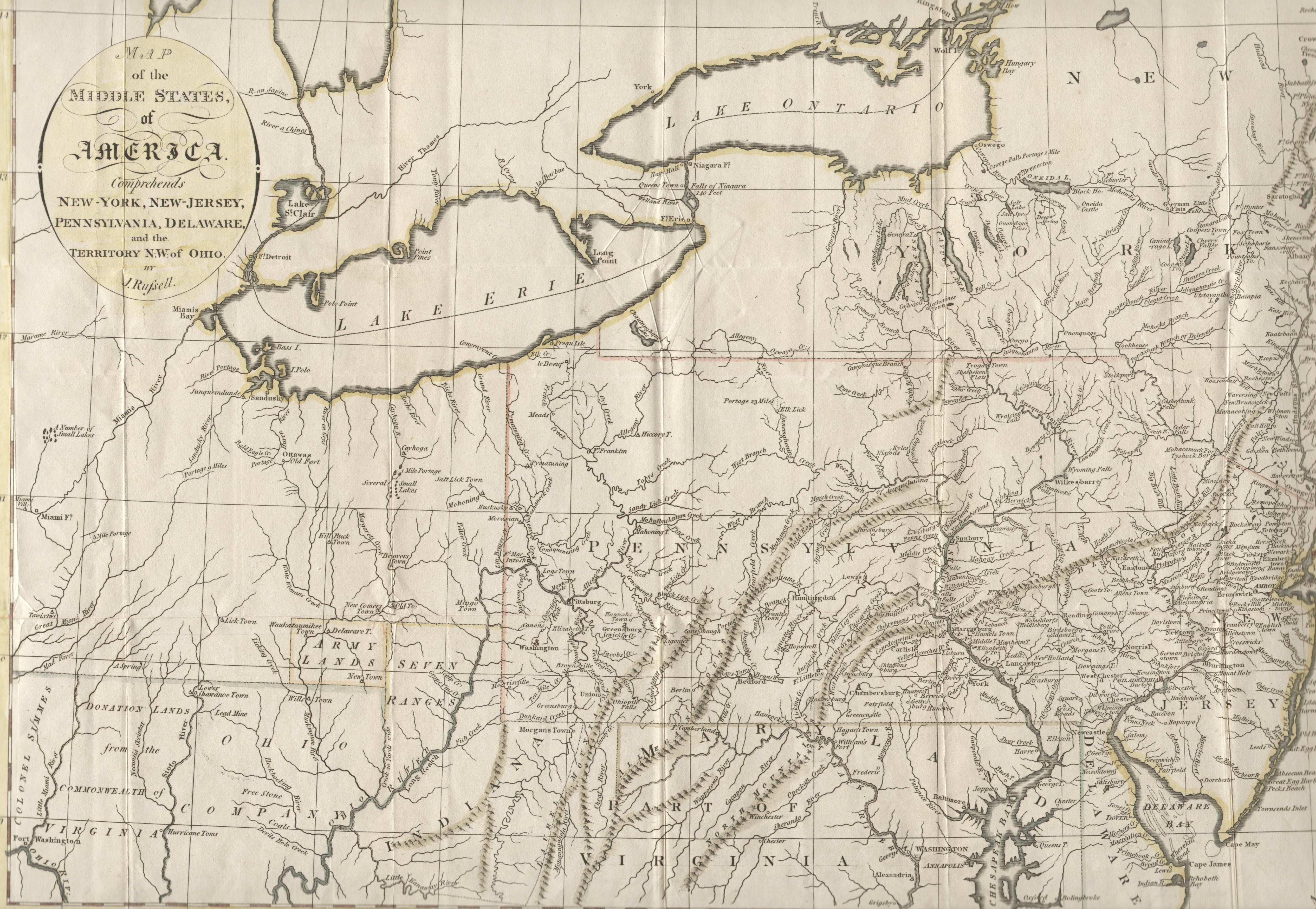
1794.12 A MAP OF
THE MIDDLE STATES, OF AMERICA. Comprehends New York, New
Jersey, Pennsylvania, Delaware, and the Territory N.W. of
Ohio by J. Russell. There is a small inset of Long Island
at the top. The image here shows most of the map
including the Pennsylvania region. This map is believed
to be from Winterbotham, a companion to map #1794.6 above.
Longitude west from London, blank verso. Scale: 1 inch =
34 miles. Size: 14 x 18 inches. |
 |
1794.13 CANADA,
LOUISIANE, ETATS-UNIS. par le S. Robert de Vaugondy
Geographe. Corrigee par le Ccn. Lamarche son successeur l'an
3me. de la Republique Franc? Grave par E. Dussy. This is
a reissue of map 1762.4 with United States added to the
title. Dated 1794 by McCorkle (#794.13), though versions
dated to the early 1780s have been seen at auction.
The area from Labrador to
Florida and west to beyond the Mississippi is covered.
There is an inset at upper left of northwest North
America. State boundaries are crudely indicated with
dotted line; "Pensylvanie" extending only to
the Alleghenies. Philadelphia is also named. This is a
recycled old map out of date when issued. Blank verso,
longitude apparently east of Ferro. Scale: 1 inch = 300
miles. Size: 9.5 x 11.5 inches. |
| |
1794.14 A NEW AND
CORRECT MAP OF THE BRITISH COLONIES IN NORTH AMERICA
Comprehending Eastern Canada with the Province of Quebec,
New Brunswick, Nova Scotia, and the Government of
Newfoundland: with the Adjacent States of New England,
Vermont, New York, Pennsylvania and New Jersey. This map
is a later edition of map 1776.7 with a new title from A
New and Elegant Imperial Sheet Atlas..., R. Laurie
and J. Whittle, London 1798. There is a notation "Col.
Arnold's Rout in 1775" referring to Benedict Arnold's
campaign during the Revolution. The map includes a
substantial part of eastern Pennsylvania whose northern
boundary is at about 42d 30m. McCorkle #794.12 |
| |
1794.15 A MAP OF
THE BACK SETTLEMENTS, published July 30, 1794, by J.
Stockdale Piccadilly. This map is from the 1794 London
edition of An American Geography by Jedidiah
Morse. The coverage includes western Pennsylvania to the
Mississippi and south to include what will become
Tennessee. Everything west of Pennsylvania is called the
Western Territory with a very strange Indiana where West
Virginia will be. The map also shows Bounty Land Grants
for soldiers and some frontier forts. |
|
|
1794.16
CARTE DES ETATS MITOYENS DE L'AMERIQUE UNIE DRESSEE D'APRES LES AUTORITES LES PLUS NOUVELLES ET LES MIEUX CHOISES par Thos. Conder G. par H. de Monthuchon a Altona 1794. A French map of the Middle Atlantic region west to Lake Michigan; apparently copied from a map by Thomas Conder. It shows little detail except for naming some rivers. |
|
|
1794.17
SKETCH OF FAYETTE'S POSITION AT BARREN HILL. A map from The history of the origin, progress, and termination of the American war By C. Stedman, London : printed for the author; and sold by J. Murray; J. Debrett; and J. Kerby, 1794. There were several printings of this two volume work. The map shows an area near the Schuylkill River where La Fayette's French troops were positioned during the Battle of Barren Hill; one of the several actions around Philadelphia when General Howe entered the city and forced Washington west to Valley Forge.
|
 |
1794.18
A NEW AND GENERAL MAP OF THE
MIDDLE DOMINIONS BELONGING TO THE UNITED STATES OF
AMERICA, VIZ:... THE DELAWARE COUNTIES, PENNSYLVANIA...
and sold by Laurie & Whittle. This map is a later issue of map 1756.10, a copy of the Lewis Evan's map, with the title changed to recognize the United States. There were several versions of that famous map issued, this apparently being the last.
It also can be seen at the Darlington Library. McCorkle #756.4, 794.6.
Blank verso; longitude from Philadelphia at top, from London at bottom. Scale: 1 inch = 34 miles. Size: 19 x 26 inches.
|


