In the 1820's colored maps
from American publishers begin to appear. The coloring was done
by hand using stencils and a light wash similar to watercolors.
Philadelphia was the major center of map publishing with Carey
& Lea, John Melish, Anthony Findley, and others. The
Historical Society of Pennsylvania was founded in Philadelphia in
1824.
Only one county was created
in this decade, Perry County in 1820 with the county seat at New
Bloomfield.
 |
1820.1
UNITED STATES, A. Fullarton & Co. London &
Edinburgh. The United States extends to the Rocky
Mountains on this map with an inset titled "Continuation
of Western Territory", i.e. Washington and Oregon,
probably added because of the Lewis & Clark
expedition. The dating of this map is uncertain, though
it likely dates circa 1819-22. There is a large "Arkansa"
Territory with 'Little Rock or Arkopolis';
Michigan is named only on the lower peninsula; Illinois (1818)
and Florida and Louisiana (1819-21) have modern
boundaries. It is unclear if Missouri is identified as a
state (1821) or territory. Texas is not named. Longitude
west from Greenwich, blank verso. Scale: 1 inch = 220
miles. Size: 8 x 10 inches. |
 |
1820.2
UNITED STATES. London, Published by C. Smith, Mapseller, No. 172 Strand, Jany. 6th. 1820. This map is page 50 from Smith s New General Atlas , C. Smith London 1820; listings for this atlas range from 1808 to 1822. The map shows the eastern United States to the Mississippi with a cutoff southern Florida that is included in an inset. Pennsylvania lacks the Erie triangle apparently due to sheer sloppiness; Indiana (1816) and Illinois (1818) are shown as states also with questionable boundaries. The image here includes most of the map. Longitude west from Greenwich, blank verso. Scale: 1 inch = 150 miles. Size: 10.5 x 13.75 inches. |
 |
1820.3
UNITED STATES. Published May 1st, 1820, By Sherwood, Neely & Jones, No. 20 Paternoster Row London. Neele & Son fc. 352 Strand. Like many maps of this period, this one shows the eastern United States from Maine to a cutoff Florida and west to the Mississippi. Louisiana and Indiana are shown as states, but Illinois is called a territory. Blank verso, longitude west from Greenwich. Scale: 1 inch = 175 miles. Size: 8 x 9.75 inches. |
 |
1820.4
STATI UNITI DI ARROWSMITH. Milano da Pietro e Giuscppe Vallardi. Deposto alla I.C. Bibblioteca. This is an Italian map of the east coast after an Arrowsmith map and dated circa 1820 here as a guess. It has also been seen dated circa 1815. Ohio (1803) is named, but the mid-western states are still shown as territories. Louisiana (1812) is not identified, so the map may date between 1803 and 1812. It shows the region from Maine to Florida and west to the Mississippi; all of Florida is included, and not cut off as in English maps which might indicate (along with the longitude marking) that it is really based on a French map. Pennsylvania has its modern boundaries. Because of large margins (~18 x 13 inches total), this printing may be separate and never cut for an atlas. Blank verso, longitude from Paris. Scale: 1 inch = 200 miles. Size: 9.5 x 8 inches. |
 |
1820.5
STATI UNITI DI AMERICA, Tav. 36 Atlan. Geogr. Marco di Pietro inc. This map is believed to be from Nuovo atlante universale.... by L. Rossi, Editore: Batelli e Fanfanim Milan 1820. It is an Italian version of map 1811.5 from Guthrie though not an exact copy. The eastern United States is shown from a cutoff Maine and Florida west to the Mississippi with a list of states on the left side; Louisiana is named but not Ohio for some reason. Some of the map features resemble much earlier maps, for example Pennsylvania without the Erie triangle. Like the Italian map above, this one has very large margins (11 x 17.5 inches total). Only one set of longitude lines is given, but marked 'del Ferro' at top and 'di Parigi' at bottom. Blank verso. Scale: 1 inch = 210 miles. Size: 7 x 8 inches. |
 |
1820.6
UNITED STATES OF AMERICA COMPILED FROM THE LATEST & BEST AUTHORITIES By John Melish 1820. Entered by an act of Congress, 10th July 1818, and published by John Melish, Improved to 1820. Engraved by Samuel Harrison. This map appears as the frontis in The Traveller's Directory through the United States: consisting of a geographical description of the United States...and a description of the roads, by John Melish. Sixth Edition. Philadelphia: Printed for the author. T.H. Palmer, printer. 1820. This is a small book of 135 pages with about 20 calendar pages at the back. This eastern United States hand colored map has some loss at the folds and is in only fair condition. It is printed on onionskin type paper and severely trimmed. The map includes Texas with outsized Missouri and Arkansas territories. Blank verso, longitude from Washington at top, from London at bottom. Scale: 1 inch = 120 miles. Size: 16 x 19 inches. |
 |
1820.7
PHILADELPHIA AND ADJACENT COUNTRY. This anonymous map appears opposite page 14 in the Melish book described above, which also includes similar maps of Boston, New York, and Baltimore. The coverage extends west past Germantown and includes a goodly chunk of New Jersey. Blank verso. No scale, but 1 inch ~ 4 miles. Size: 5.5 x 3.25 inches. |
 |
1820.8
UNITED STATES. Philad. Published by M. Carey & Son 1820. Although dated 1820, the details of this map are confusing. Indiana (1816) appears to be identified as a state, while Louisiana is shown as part of Mississippi territory. It may be a markup of an earlier plate. The map folded into a small book (6.5 x 4 inches) as it is attached to the frontispiece page of the book. This is a 3 x 5 inch engraving of the death of General Richard Montgomery; a British officer who came to America during the French and Indian war and settled in New York afterwards. He joined the revolution on America's side and led the expedition into Canada where he was killed. His replacement was Benedict Arnold. The back of this frontispiece has an owner's manuscript note. This map likely comes from a history book. Intaglio print, blank verso. Longitude from London at top, from Philadelphia at bottom. Scale: 1 inch = 185 miles. Size: 8 x 9.5 inches. |
 |
1820.9
UNITED STATES. J.C. Russell jun. del. et sculp. Plate XXIL at top. This map is from an unknown book. A small map of the eastern United States, it shows Illinois (1818) as a state, but not Missouri (1821), so is dated circa 1820 here. Also, Florida (ceded from Spain in 1819) is cut off but appears shown as part of the country. Maine (1820) is also truncated. Rivers and mountains are indicated and a few towns named. Originally folded in two, so possibly from a small atlas. Blank verso, longitude west from London, intaglio print. Scale: 1 inch = 206 miles. Size: 7.25 x 8.5 inches. |
 |
1820.10
PENNSYLVANIA AND NEW JERSEY. This small, undated and anonymous map was originally folded and probably comes from a small history or geography book. The major clue to its dating is the extensive road network shown, but without any railroads, so dated circa 1820 here. Many towns are shown and a few rivers, but the counties are not outlined. Intaglio print with hand color. Blank verso, longitude from Washington, so this map comes from an American book. Scale: 1 inch = 65 miles. Size: 4.75 x 6 inches. |
 |
1820.11
THE UNITED STATES. Published by Cummings & Hilliard No. 1 Cornhill Boston. W.B. Annin Sc. This map is from School Atlas to Cummings' Ancient & Modern Geography, Sixth edition, which dates circa 1820; Illinois (1818) is shown as a state but not Missouri (1821). The United States is shown west to the Mississippi but only the eastern part of Louisiana is shown. Florida is cut off as is the tip of northern Maine. Lake Superior and the Mississippi mouth extend beyond the neat line. Hand applied outline color, intaglio print, blank verso. Longitude from Philadelphia at bottom, from Greenwich at top. Scale: 1 inch = 146 miles. Size: 9 x 11.5 inches. |
 |
1821.1
UNITED STATES, London:Published
by C. Smith, Mapseller, 172 Strand, Jany. 6th. 1821. Page
30 from Smith's New General Atlas by Charles
Smith. Dates of 1815, 1816, 1822 have been found for this
atlas with the following listing: Smith's New general
atlas : containing distinct maps of all the
principal empires, kingdoms, & states throughout the
world, arranged according to the general treaty signed in
Congress at Vienna, June 1815 Publisher: London : printed
for C. Smith, mapseller extraordinary to His Majesty,
1822. Maps engraved by E. Jones, B. Smith, and J. Bye.
This map shows the east coast from Nova Scotia to a cut
off Florida which is shown in an inset, and west to the
Mississippi. Illinois (created 1818), Mississippi (1817)
and Alabama (1819) are shown but not Missouri (1821).
The map is simplified somewhat from the one shown above from the 1820 atlas, but Pennsylvania is still without the Erie triangle.
Longitude west from Greenwich, blank verso. Scale: 1 inch
= 220 miles. Size: 7 x 9 inches. |
 |
1821.2
UNITED STATES OF AMERICA. Published by John Thomson, Edinburgh. Hewitt, sculp. This undated map is page 32 from an unknown source; it shows the eastern United States from Maine to a cutoff Florida. Missouri seems represented as a state (1821), while Arkansas (1836) is misspelled with incorrect boundaries; lower Michigan (1837) is named but the upper part is not included. Thomson published until the 1860s while Hewitt was active circa 1812-28 per library listings. There is an English library listing for: The Edinburgh School Atlas : containing distinct maps of the several empires, kingdoms and states, in the world, from original drawings, made & engraved, expressly for this work by N. R. Hewitt. Edinburgh : John Thomson & Co., [ca.1820]; and this would seem the most likely source for this map. It appears to have been bound along the top edge, or left edge going by the page number. Blank verso, longitude west from Greenwich. Scale: 1 inch = 200 miles. Size: 7 x 9 inches. |
 |
1821.3
ETATS UNIS PAR ARROWSMITH. P. XXX. Semen Juene sculp. This map is thought to be from Nouvel Atlas Portatif, comprenant la geographie universelle, ancienne et moderne by Eustache Herisson; Desray; Adrien-Hubert Brue; J.B. Lallemand Publisher: Paris : Chez Desray, Libraire, 1821. This is the 6th edition of an atlas first published in 1811. As the title indicates, it is based upon an older Arrowsmith map, probably map 1802.1 which it resembles. Ohio (1803) is shown as a state, but not Louisiana (1812). The coverage is west to beyond the Mississippi with Maine and Forida cut off. Intaglio print, blank verso. Longitude west from Paris. Scale:1 inch = 182 miles. Size: 8 x 10 inches. |
 |
1821.4
UNITED STATES. Engraved for Woodbridge's Rudiments of Geography. Entered according to Act of Congress, the 28th day of September 1821, by William C. Woodbridge of the state of Connecticut. This is a student geography map of the eastern United States with a cutoff Maine and Florida.
Maine is shown in an inset at lower right. The map comes from Woodbridge's Larger Atlas on a new plan, Hartford: published by Samuel G. Goodrich, circa 1821. An 1823 edition of this same map appears in the article Pennsylvania
in Old Geography Books. Intaglio print, hand color. Longitude west from London at bottom, from Washington at top. Blank verso. Scale: 1 inch = 120 miles. Size: 8.75 x 11 inches.
|
 |
1822.1
GEOGRAPHICAL, STATISTICAL, AND HISTORICAL MAP OF
PENNSYLVANIA, Engraved by J. Yeager, Plate No. 18 from
the first edition of H. C. Carey and I. Lea's American
Atlas, Philadelphia 1822. The census date of 1820 is
on the map in text along the bottom. The map itself is on
the top half of the page. Other editions of this atlas
appeared in 1823, 1827 (Lister). Listed on page 680 of
Phillips. Blank verso. Scale: 1 inch = 22 miles. Size: 12
x 18 inches (map only). |
 |
1822.2
MAP OF THE NATIONAL ROAD BETWEEN CUMBERLAND AND WHEELING, Engraved for J. Melish's Description of the United States & Travellers Directory. This is one of the earliest maps of the old National Road across southwestern Pennsylvania. Many towns are shown, including W. Alexandria, Washington, Union(town) in heavier type. The map is printed on very thin paper, originally folded, and from A Geographical Description of the United States, with the Contiguous British and Spanish Possessions, by John Melish, Philadelphia 1822. The first edition appeared in 1816, but the 1822 edition had 12 regional maps including this one. The National Road west (originally called the Cumberland Road) was proposed in an 1806 Act of Congress. The act was signed by President Jefferson who appointed the first commissioners. It was planned as a way to tie the states being created from the old Northwest Territory, Ohio, Indiana, Illinois, Michigan, into the east. Construction began on the section west from Cumberland in 1811. By 1818 coaches were running between Washington and Wheeling. In 1819 construction came to a halt due to a financial panic. In 1822 a bill for repair of the road and authority to collect tolls passed the Congress, but was vetoed by President Monroe. He held that Congress did not have the right of jurisdiction and construction, but Monroe also recommended a national system of internal improvements. A number of alternatives were examined for additional 'National Roads', including a route up the Susquehanna River valley (see the 1827 map in 19th Century maps). However only the Old National Road, today's US 40, was constructed by the Federal government during the 19th century. It was continued west across Ohio in the late 1820's eventually reaching Vandalia, then the capital of Illinois. There is a National Road Museum in Zanesville, Ohio, and many books have been written about the road. No Longitude, blank verso. Scale: 1 inch = 10 miles. Size: 6 x 11 inches. |
 |
1822.3
MAP OF THE WILKES'BARRE &C ANTHRACITE COAL FORMATION PL. II. Range of the Anthracite Formation of Pennsylvania. This map is from American Journal of Science, edited by Silliman, Vol IV, New Haven, CT, 1822; and accompanies an article: "Account of the mines of Anthracite in the Region about Wilkesbarre, Pa." The coverage is from Bradford County south to Harrisburg, and from Harrisburg east to Lehigh County. The anthracite formations are shown by dotted lines running from the Lackawanna valley south through Schuylkill and into Dauphin County. Major towns shown include Harrisburg, Reading, Sunbury, Wilkes-Barre, Pittston. Note the absence of Scranton, which did not yet exist. This map has the distinction of being the first map printed by lithography in the United States; see the article A Close Look at Historical Maps of Pennsylvania. Originally folded, no longitude, blank verso. Scale: 1 inch ~ 20 miles. Size: 9.25 x 7.5 inches. |
 |
1822.4
(UNTITLED) PL.VII. This untitled map is believed to come from Geography for Schools, upon a plan entirely new, consisting of an analytical arrangement of all the great features of nations, particularly adapted to an atlas, by Luke Drury, Miller & Hutchins Publishing Co. Providence Rhode Island 1822. It is a simple map of the state showing the major towns, streams and mountains. An unusual feature is the printed specification of longitude and latitude boundaries. Blank verso, intaglio print, no longitude markings. Hand color outline. Scale: 1 inch = 55 miles. Size: 8.2 x 9.75 inches. |
 |
1823.1
PENNSYLVANIA, B. T. Welch & Co. Sc. This map is from A
General Atlas of All the Known Countries of the World,
published by F. Lucas Jr., Baltimore 1823. It can be
dated 1820-31 by the counties shown. Lucas first
published an atlas circa 1816 per Lister. Blank verso. Scale:
1 inch = 20 miles. Size: 11 x 17.5 inches. |
 |
1823.2
UNITED STATES. A map from Walkers Atlas, London, published by Longman, Hurst, Rees, Orme & Brown, Paternoster Row, 1823. Drawn & engraved by Sidy Hall, Bury Strt. Bloomsby. It shows the United States from Maine to a cutoff Florida and west to past the Mississippi. There is an inset of Florida at lower right. Missouri (1821) shown as a state. This map has been seen at auction dated 1828 and 1831 also. Blank verso, longitude west from Greenwich. Scale: 1 inch = 206 miles. Size: 7.25 x 9.25 inches. |
 |
1823.3
MAP OF PENNSYLVANIA AND NEW JERSEY. By H.S. Tanner, Entered according to Act of Congress the 20th day of August 1823 , Published by H.S. Tanner, Engraved by H.S. Tanner & assistants. This map is one of the large state maps published in Tanner s A New American Atlas in 1823; it dates to 1820-1831 by the counties shown. Ristow has an entire chapter on Tanner. The first edition of this atlas was published in 5 folios between 1819 and 1823. The first folio of 1819 had maps of continents. the second folio, also 1819, had maps of New York, Ohio, Indiana. The third folio (circa 1820) had maps of New England, Virginia, Maryland, Delaware, Louisiana, Mississippi. The fourth folio of 1822 had only a map of North America. The fifth folio of 1823 had maps of Pennsylvania and New Jersey, Kentucky and Tennessee, North and South Carolina, Georgia and Alabama, Illinois and Missouri, and Florida. There were subsequent editions of this atlas up to 1839 (per Lister). 1825 and 1827 versions were seen mounted on linen and folded as traveler s maps. Roads are shown, and mountains in relief. Blank verso. Scale: 1 inch = 18 miles. Size: 24 x 31 inches. |
 |
1823.4
PENNSYLVANIA AND NEW JERSEY. N. & S. S. Jocelyn sc. Undated, this map dates between 1820 and 1831 by counties shown, and is from An Atlas of the United States On an Improved Plan..., by Sidney E. Morse A.M., New Haven: Engraved and published by N. & S.S. Jocelyn 1823. It is covered with numbers that refer to an index of towns on a separate sheet, although a few towns are named. There is a round inset of Philadelphia at bottom. Longitude from Washington at top, Greenwich at bottom, blank verso. Scale: 1 inch = 43 miles. Size: 7.5 x 9.75 inches. |
 |
1823.5
A MAP OF THE UNITED STATES OF AMERICA, By H.S. Tanner. Engraved by H.S.Tanner. Published by Bennet & Walton, Philadelphia, in the William Darby edition of Brookes' Universal Gazetteer. This map includes all of the eastern United States to just past the Mississippi. Towns and cities, mountains, rivers, Indian tribes are identified. Wisconsin and Minnesota are together called North West Tery., with Western Territory appearing farther west. Michigan territory is shown as well as Alabama (1819), Maine (1820), and Missouri (1821). The part of Texas shown is called Spanish Province of Texas. Intaglio print, hand color, blank verso. Longitude from Washington. Scale: 1 inch = 126 miles. Size: 15 x 12.5 inches. |
 |
1824.1
MAP NO. 1 THE OHIO from The Navigator:
Containing Directions for Navigating the Ohio, and
Mississippi Rivers; With an Ample Account of These Much
Admired Waters...And a Concise Description of Their Towns,
Villages, Harbors, Settlements, &c.With Maps of the
Ohio & Mississippi to Which is Added An Appendix,
Containing an Account of Louisiana, and of the Missouri
& Columbia Rivers, As Discovered By the Voyage Under
Captains Lewis & Clark, by Zadok Cramer, printed
and published by Cramer & Spear, Franklin Head
Bookstore, Wood Street, Pittsburgh 1824. The first
edition of Cramer's Navigator was printed by
John Scull in Pittsburgh in 1802. Cramer died in 1813 but
his Navigator continued to be published into the
1840s. It was the first navigational guide to the Ohio
and Mississippi Rivers and important for developing
shipping. It contains a woodcut map of Pittsburgh &
the Falls of the Ohio, along with twelve woodcut maps of
the Ohio, and thirteen of the Mississippi. This map is
the first of the Ohio and the Pittsburgh point is shown
at the top. The maps are almost too crude to be used and
pilots relied upon the written instructions. See the
modern river pilot's map for 1974. The appendix on Lewis
and Clark was first included in the 1808 edition. Cramer
also published a Pittsburgh Almanac c1800. Size:
7 x 4 inches. This book is now on line at Historic
Pittsburgh . |
 |
1824.2
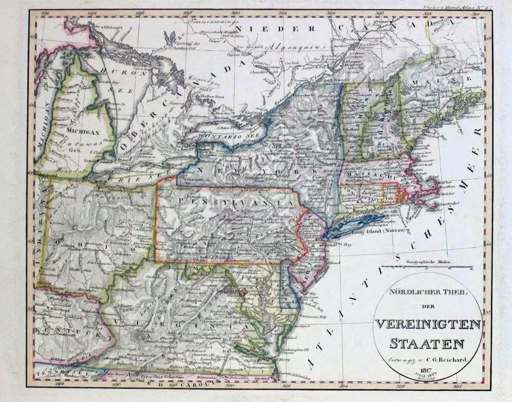
NORDLICHER THEIL DER VEREININGTEN STAATEN, Entn. U. Gez. v. C.G. Reichard 1817. Revid:1824 gest V.L. Hefs. Stieler s hand-atlas no. 47. This is plate 47 from Stieler s hand-atlas showing the northeast from Maine to Virginia and west to include Ohio. Many towns are named, and mountains indicated by hashing. Adolf Stieler lived from 1775 to 1836 and his atlas continued publication into the 20th century. This map originally appeared in Hand atlas uber alle Theile der Erde by Adolf Stieler, published by Justus Perthes, Gotha,1817. Longitude east (from Ferro?) with Philadelphia at about 302d 30m, blank verso. Scale: 1 inch = 71 miles. Size: 11 x 13.5 inches. |
 |
1824.3
PLAN OF THE CITY OF PHILADELPHIA COMPILED FROM ACTUAL SURVEYS, by F. Drayton 1824. R.H. Filbert sc. Downtown Philadelphia is not yet completely filled with buildings on this early map. The famous state penitentiary is prominent. This copy might be an old reproduction browned by the sun, but the presence of hand applied outline color would tend to indicate it is an original; there is no indication it was cut from a book or atlas.This map is similar to map 1824.8 below and was probably copied from it. Also, it appears to be a lithograph, and so would be one of the first American lithograph maps made, as the earliest such map is dated to 1822 (see Phillips in Woodward). Blank verso, no longitude. Scale: 1 inch = 2000 feet. Size: 11.5 x 9.5. |
 |
1824.4
ETATS-UNIS DE L AMERIQUE SEPTENTRIONALE, Prefscit par P. Lapie, Geographe. Chamouin. This map is page 40 from a French atlas. In pencil at bottom is written "1824 (Phillips 744)", apparently a reference to Phillips' Library of Congress catalog, so it is dated 1824 here. Illinois (1816) and Missouri (1821) are shown as states. The eastern United States and southern Canada is covered from Newfoundland to Florida and west to beyond the Mississippi. States are outlined in color. The LOC has a map with this name dated to 1810 but this one appears to date later. The LOC also has the listing: Atlas classique et universel de geographie ancienne et moderne, Lapie, M. (Pierre), 1779-1850. 3.ed. Published: Paris, Anselin & Pochard; Picquet, 1824: and this is the likely source of this map. Longitude from Paris, blank verso. Scale: 1 inch = 250 miles. Size: 9 x 12 inches. |
 |
1824.5
PENNSYLVANIA. Published by A. Finley Philada., Young & Delleker sc. This is plate 15 from the 1st edition of Anthony Finley s A New General Atlas, comprising a complete set of maps, representing the great divisions of the Globe . 1824. The atlas was published in 1824, 1829, 1830, 1831, 1833 per Lister. Per Ristow, it was published annually 1826-1834, and later maps appear identical. It can be dated 1820-31 by the counties shown. Major towns and roads are shown and rivers and mountains by shaded relief. Blank verso, longitude from Greenwich at bottom, from Washington at top. Scale: 1 inch = 30 miles. Size: 8.75 x 11.25 inch. |
 |
1824.6
PENNSYLVANIA. Engd. by R. Campbell. This map accompanied the October, 1824 issue (Vol. I No. 2) of Darby's Repository with the articles Geographical View of Pennsylvania and History of Pennsylvania. It is a standard Pennsylvania map of the time with hand colored bands, referred to in the text, representing geological regions. It might be pushing it to call this the first geological map of the state, but it is certainly the first attempt at one. Darby explains that the map is based on Maclure's geological map of the (eastern) United States published earlier with modifications made from his own observations. His short description of the geology is followed by a geographical summary of the state and a history. The only two numbers of the Repository, published by William Darby in Philadelphia, dealt mainly with the geography of Pennsylvania, the history of North America and Pennsylvania, and statistics on various proposed canals and other topics. Diagrams and maps were included. Blank verso, longitude from Greenwich at bottom, from Washington at top. Scale:1 inch = 30 miles. Size: 9.25 x 11 inches. |
 |
1824.7
UNITED STATES. J.G. Melish, del. This is the son of the well known John Melish.This map is in The Life of George Washington, with curious anecdotes equally honorable to himself, and exemplary to his young countrymen, by M.L. Weems, formerly Rector of Mount Vernon Parish. Twenty-sixth edition, Philadelphia: H.C. Carey & I. Lea. 1824. The earliest book with this title at the Library of Congress is dated 1808, however Weems wrote an earlier version under a different title published in 1800. This book has the now famous apocryphal stories of the president. The map, folded into the book, shows the country from Maine to a cutoff Florida and west to beyond the Mississippi. It is labled No. 28 and apparently was lifted from another Carey publication. Missouri (1821) appears to be shown as a state, so the map is topical to the date of the book. Intaglio print. Blank verso, longitude from Washington at bottom, from London at top. Scale:1 inch = 180 miles. Size: 8 x 9.5 inches. |
 |
1824.8
PLAN OF THE CITY OF PHILADELPHIA COMPILED FROM ACTUAL SURVEY, by F. Drayton, published by H.C. Carey & I. Lea 1824. This map comes from Philadelphia in 1824; or, a brief account of the various institutions and public objects in this metropolis.... with a plan of the city, view of the water-works, and other engravings. Philadelphia: H.C. Carey & I. Lea - Chestnut Street. August, 1824. L.R. Bailey, Printer. This 235 page book has this map folded into the back cover. Also included in the book is the map described below, an engraving of the waterworks in front and a floor plan of Independence Hall and adjacent buildings which were being used as city buildings as the capitol moved to Harrisburg in 1812. The map shows the new Eastern Penitentiary which was under construction at this time and did not open until 1829. The districts of the city are indicated by coloring and large letters with a legend at upper left. This map is similar to map 1824.3 above and probably came first. It was republished in 1830. Intaglio print, blank verso. Scale:1 inch ~ 2 blocks. Size: 15 x 17 inches. |
 |
1824.9
A PANORAMA OF THE PRINCIPAL OBJECTS OF INTEREST IN PHILADA. This simple map is folded inside the same book as the map above. It shows just the downtown area with a numbered list of important buildings identified on the map and a legend on each side. Broad and Market are the only streets shown, the other lines are just a grid. Intaglio print, blank verso. Scale:1 inch ~ 6 blocks.Size: 5.5 x 7.5 inches. |
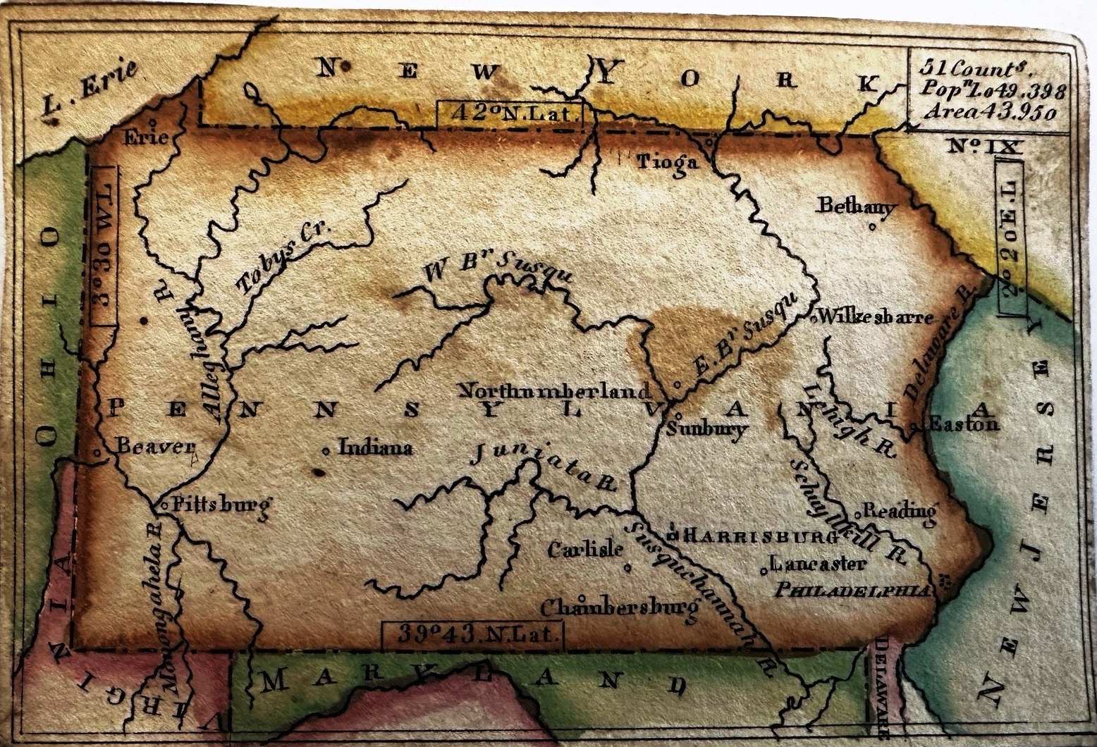 |
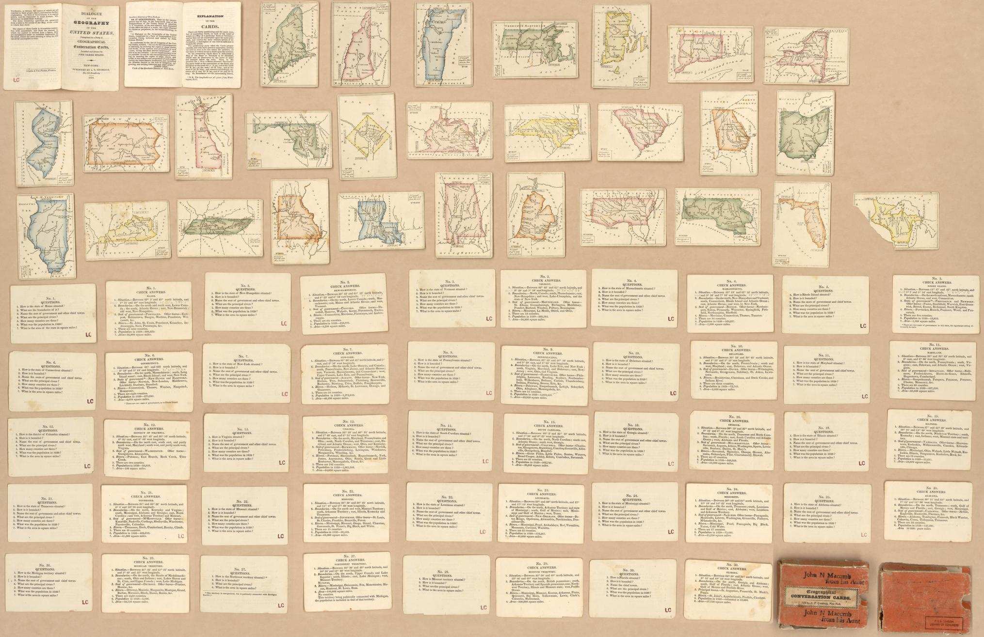
1824.10
(UNTITLED) This small map, with accompanying question and answer card, is believed to come from the card collection called Geographical Conversation Cards, invented and drawn by John Graeme Melish (apparently not 'the' John Melish), and published by A.T. Goodrich, New York, 1824, per a Library of Congress listing. An image of this 19th century card collection from the Library of Congress shows the Pennsylvania card matches this one but without the red and green coloring. The question and answer cards for the various states are also illustrated in this image. Blank verso, intaglio print. Scale: 1 inch ~ 100 miles. Size: 2.3 x 3.5 inches. |
 |
1824.11
NORDLICHER THEIL DER VEREINIGTEN STAATEN. Entw. U. Gez. V. C. G. Reichard 1817 revid. 1824 gezt. V. L. Hess. Stieler's Hand-atlas No. 47 at upper right. This map of the northeast (and lower Canada) includes New England, New York, Pennsylvania, Ohio, Delaware, New Jersey, Virginia and parts of Michigan and Kentucky along with most of the Great Lakes. It features hand-colored boundaries, rivers, and mountains shown by hatching. This is a later issue of an 1817 map as indicated. Adolf Stieler (1775-1836) was a German cartographer who worked most of his life in the Justus Perthes Geographical Institute in Gotha. His Hand-atlas was a leading German atlas through the 19th century. Christian Gottleib Reichard (1758-1837) was a German cartographer and collaborated on the first Stieler's Hand-atlas. Blank verso. Longitude east from (probably) Ferro. Scale: 1 inch = 69.5 miles. Size: 11 x 13.5 inches. |
 |
1825.1
MAP OF THE ROUTES IN NEW YORK, NEW ENGLAND &
PENNSYLVANIA, DRAWN FOR THE NORTHERN TRAVELLER, D.S.
Throop sc., printed at W. Hooker's Nautical Office, 202
Water Street N. York. This small map is two sheets
folding along a vertical centerline and is undated. It
shows the northeast with straight lines connecting towns.
The ones identified in Pennsylvania are Philadelphia,
Pittsburgh, Harrisburg, Reading, Orwigsburg, Mt. Carbon;
the importance of these last two towns is a mystery. The
Library of Congress has 7 records of The Northern
Traveller by Theodore Dwight dating from 1825 to
1834. All contain maps and this particular map appears to
have been used in several editions. No longitude, blank
verso. Scale: 1 inch = 110 miles. Size: 6 x 7 inches. |
 |
1825.2
PENNSYLVANIEN, GEOGRAPHISCH - STATISTISCHE UND HISTORISCHE CHARTE VON PENNSYLVANIEN. Weimar, im verlage des Geographischen Instituts 1825. This is a German version of Carey & Lea s 1822 map (1822.1). The map itself is 10.5 x 16 inches and is surrounded by text; It differs from the Carey & Lea map where text is only at the bottom and the remaining text is on another sheet. Geographical features are in German, i. e. berg for mountain, but town names are in English. The counties are outlined in color, instead of completely colored as in the 1822 map. This map has been attributed to Carl Ferdinand Weiland; and, from Library of Congress listings, may have appeared in Atlas von Amerika by Carl Ferdinand Weiland published in 1829 also. A French edition of the Carey & Lea atlas was published by Buchon in 1825, and is also shown here. This German version is apparently somewhat rarer with better engraving quality; and Weiland also added several maps which did not appear in the other editions. Blank verso, longitude from Washington. Scale: 1 inch = 22 miles. Size: 17 x 21.5 inches (printed sheet). |
 |
1825.3
ETATS-UNIS D'AMERIQUE 1825. A Paris, Chez J. Carey Rue Haute Feiulle No. 18. La lettre gravee, par H. Mardelet, Rue St. Jacques No. 27, a Paris. Gravee par Ales, Rue Des Noyers, No. 50 a Paris. This large double page map is from Atlas Geographique, Statistique,Historique et Chronologique des deux Ameriques et Iles adjacentes... by Jean-Alexandre Buchon, published in 1825. The atlas was a French edition of Carey & Lea's A Complete Historical, Chronological, and Geographical American Atlas, published in Philadelphia 1822. However, it differs from its American model with several new maps, including this one, which shows the eastern United States from Maine west to the Rockies and south to include all of Florida. Towns and rivers are named and some roads are indicated. Blank verso, longitude from Washington at top, from Paris at bottom. Scale: 1 inch = 120 miles. Size: 16.5 x 20.75 inches. |
 |
1825.4
CARTE GEOGRAPHIQUE, STATISTIQUE ET HISTORIQUE DE LA PENSILVANIA. No. xxii, grave par B. de Beanpre graveur au Depot Gal. de la Guerre, Rue de Vaugirard No. 81.This title appears across the top; the title on the map is PENSILVANIE. This is the Pennsylvania map from the atlas by Jean-Alexandre Buchon mentioned above. It contained 63 plates on double page including 51 colored engraved maps; 34 maps are devoted to North America, including 28 which represent states of the union, and 17 others for South America and the Antilles. As also mentioned above, the atlas was a French edition of Carey & Lea's 1822 atlas. There were some differences including the added United States map shown above. This Pennsylvania map retains English names but French names are used for some geographical features such as montagne for mountain. As in the Carey & Lea and German versions shown above, this map is surrounded by text. Longitude from Washington at top, from Paris at bottom, blank verso. Scale: 1 inch = 21 miles. Size: 11.5 x 17 inches (map only). |
 |
1825.5
AMER. SEP. PARTIE DES TATS-UNIS. NO. 51. Dressee et dressine par Ph. Vandermailen. La lettre par Ph. Lippens. Dressee sui ?? et litho par H. Ode 1825. This is Plate 51 compiled and published by Belgian geographer Philippe Vandermaelen (1795-1869) from his Atlas universel de geographie physique, politique, statistique et mineralogique, Brussels, 1827. The atlas was a huge work of six volumes with a total of 378 map sheets drawn as globe gores on a conical projection at a 1:1,641,836 scale - the whole of which assembled to form a globe of 7.775 meters in diameter. North America was covered in volume 4. The completed atlas offered the largest picture of the earth's surface that had ever been recorded. This project allowed Vandermaelen to found the Brussels Geographic Institute, whose library had the only example of the giant globe ever constructed from the plates of the atlas. This map shows only the eastern part of Pennsylvania; the only states shown in toto are New Jersey and Delaware. The rest of Pennsylvania appears in the adjacent map to this one. The ocean is occupied by a large table. More information on the atlas is at the Princeton Library. Blank verso, longitude from Paris. Scale: 1 inch = 26 miles. Size: 18.75 x 22 inches. |
 |
1825.6
LE PROVINCIE SETTENTRIONALI DEGLI STATI UNITI, an
anonomous Italian map of uncertain date and origin with
the hand color probably done later. It dates 1788-89 by
Pennsylvania counties identified and circa 1790 by the
counties shown for other states. A closeup of
Pennsylvania is shown in this
detail
. The District of Columbia (1791)
and the Erie triangle (1792) are shown. It resembles the
United States map in the French edition (1807) of
Marshall's Life of Washington (see map 1807.2) but with
less detail and is slightly smaller; however no record of
an Italian edition has been found. It also resembles the
circa 1782 Bonne map, and has been seen for sale
identified as from an early 1800s Italian edition of Rochefoucault-Liancourt's
Travels, but no Italian edition is known. It was reported seen in the 1825 edition of Storia della Guerra Americana scritta by Carlo Botta, published by Formigli in Firenze in 1825, so that date is used here. There is a companion map of the southeast titled LE PROVINCIE MERIDIONALI DEGLI STATI UNITI.
The longitude is west of Ferro at bottom, and west of 'Parigi'
at top, indicating it is based on a French map. Blank verso. Scale: 1 inch =
40 miles. Size: 12 x 18 inches. |
 |
1825.7
MAP OF THE COUNTRY CONTIGUOUS TO THE CHESAPEAKE & DELAWARE CANAL. This map comes from Sixth General Report of the President and Directors of the Chesapeake and Delaware Canal Company; June 6, 1825; which is a twelve page booklet containing two foldout maps. The first map is shown here and was drawn & engraved by H.S. Tanner. It shows the region from Philadelphia south to Salisbury and west to Lancaster. Roads are shown. The second and larger scale map is titled "Chesapeake & Delaware Canal and also by Tanner. It is not shown here since the canal line does not run through Pennsylvania. As shown on this map, it runs through Maryland and Delaware. Intaglio print, longitude from Washington, blank verso. Scale: 1inch = 8 miles. Size: 8.5 x 11 inches. |
 |
1826.1
MAP OF PENNSYLVANIA, NEW JERSEY AND DELAWARE CONSTRUCTED
FROM THE LATEST AUTHORITES, published by A. Finley,
Philad., J. H. Young Sc., D. H. Vance Del. This map is
from Anthony Finley's New American Atlas published
in 1826 (Lister). It can be dated 1820-31 by counties
shown. Populations by county in 1810 and 1820 are printed
on the map. Listed on page 680 of Phillips. Blank verso.
Scale: 1 inch = 18 miles. Size: 17 x 22 inches. |
 |
1826.2
MAP OF A RECONNAISSANCE BETWEEN BALTIMORE AND PHILADELPHIA, EXHIBITING THE SEVERAL ROUTES OF THE MAIL ROAD CONTEMPLATED BY THE RESOLUTION OF CONGRESS APPROVED ON THE 4TH OF MAY 1826. S. Bernard Brigr. Genl. Member of the Board of Intl. Improt. William Tell Poussin Capt. Top. Engs. and assistant to the board. This map is from the government publication HR Doc #94, 19th Congress, 2nd session, and may have been published in later documents also. It describes the post routes being considered between Philadelphia and Baltimore. The map extends from Philadelphia on the right to Baltimore on the left, and shows the roads through Pennsylvania, Delaware, into Maryland. Roughly one third of the map includes Pennsylvania and is shown here; the orientation is west of north. It is finely engraved showing great detail and is one of the few road maps from this period. Originally folded. Blank verso. Scale: 1 inch = 3 miles. Size: 9 x 31 inches. |
 |
1826.3
MAP OF PENNSYLVANIA, CONSTRUCTED FROM THE COUNTY SURVEYS AUTHORIZED BY THE STATE; AND OTHER ORIGINAL DOCUMENTS By John Melish. Engraved by B. Tanner. Corrected to 1826. Entered according to Act of Congress, the 7th day of June, 1822, by John Melish... . Published by B. Tanner, Engraver, No. 74 South Eighth Street, Philadelphia. This is a very large linen backed wall map on rods, six joined sheets engraved with hand outline color, No. 66 in Simonetti. It is the fourth edition of Melish's map of Pennsylvania, considered his greatest cartographic achievement. The first edition was published in 1822, with subsequent editions in 1824, 1825, 1826, 1832. According to Babinski, few copies (~100 or less) were printed for each of the first three editions and only the 1826 and 1832 versions are usually seen. The map was authorized by an act of the commonwealth in 1816, and based on county maps prepared by different surveyors from about 1816 to 1820. Melish delivered advance printed copies of the map for legislative approval in March of 1822. After Melish's death in December of 1822, amidst legal tangles due to his death, subsequent editions were updated, revised and published by Benjamin Tanner. There is an explanatory statement from Melish at bottom left with contributing surveyors and assistants names, statistical tables and legend at center. All of New Jersey and most of Maryland and Delaware are included but less detail is shown for them. Blank verso, longitude from Washington. Scale: 1 inch = 5 miles. Size: 48 x 72 inches. |
 |
1826.4
MAP OF THE UNITED STATES DRAWN FROM THE BEST APPROVED SURVEYS. Published by Solomon Schoyer, New York. Engraved by G.W. Merchant, Albany 1826. This pocket map shows the eastern United States to beyond the Mississippi almost to the Rockies. It folds into a 6 x 4 inch red cardboard cover and the map is pasted on both back and front covers. The front has the title "U. STATES." On the map at lower left is a large untitled engraving of an eagle with wings displayed, wearing a shield with stripes, arrows in left talon and olive branch in its right, perched on an islet, in its beak a banner titled E Pluribus Unum and 15 stars in the background. This map is listed in the Library of Congress database, but without an image. Intaglio print, blank verso, longitude from Washington at top, from Greenwich at bottom. Scale:1 inch = 120 miles. Size: 16 x 20 inches. |
 |
1826.5
MAP OF THE COUNTRY BETWEEN WASHINGTON & PITTSBURGH REFERING TO THE CONTEMPLATED CHESAPEAKE & OHIO CANAL AND ITS GENERAL ROUTE AND PROFILE. OCTOBER 1826. This map comes from Message from the President of the United States, transmitting a Report from the Secretary of War with that of the Board of Engineers, for internal improvement, concerning the proposed Chesapeake and Ohio Canal. 19th Congress, 2d session, Doc. No. 10, December 7, 1826. Washington: Gales & Seaton 1826. The "message" is a book filled with text and many foldout tables on construction of the proposed canal. At the back is this map. The topography is indicated in some detail with hash marks. The route follows the line actually built from Washington to Cumberland. From there the intended route follows Wills Creek north, crosses the Allegheny Front through a 4 mile (!!) tunnel and then follows the Casselman and Youghiogheny rivers down to Pittsburgh. There are elevation drawings at the top and bottom. As an original document on this famous canal, this would be a rare map were it not in a government document. The map is an intaglio print with the route hand marked in red. Scale: 1 inch = 8 miles. Size: 17 x 24 inches. |
 |
1826.6
NEW-YORK N.JERSEY AND PENSYLVANIA. J.G. Melish, del. J. Yeager, sc. J.G. Melish was the son of John Melish. This map is from A Connected View of the Whole Internal Navigation of the United States by
George Armroyd, published by H.C. Carey & I. Lea, Philadelphia 1826. Canals are hand colored in red, boundaries in yellow. This is apparently the second state of this map. The first state of the map was published in
The Juvenile Atlas or a Series Of Maps, To Illustrate the Old and New Worlds, Philadelphia, published By H.C. Carey & I. Lea 1822. And it is possible the same map was used in later school atlases.
Intaglio print, longitude from Washington, blank verso,
originally folded. Scale:1 inch = 56 miles. Size: 7.75 x 9.25 inches. |
 |
1826.7
UNITED STATES. Entered according to Act of Congress May 6th, 1826 by S.G.Goodrich. S. Stiles, Utica. This small map is probably from a Goodrich geography book. It shows the eastern United States west to beyond the Mississippi with the northern tip of Maine cut off. Lake Superior and southern Florida extend beyond the neat line. Missouri (1821) is shown as a state. Intaglio print. Blank verso. Longitude from Washington at top, Greenwich at bottom. European cities are named along the left and right edges placed at their latitudes. Scale: 1 inch = 185 miles. Size: 9 x 9 inches. |
 |
1827.1
MAP OF THE COUNTRY EMBRACING THE SEVERAL ROUTES EXAMINED
WITH A VIEW TO A NATIONAL ROAD FROM WASHINGTON TO LAKE
ONTARIO, compiled by F. Harrison, Jr., drawn by A. J.
Stansbury, engraved by W. Harrison, Georgetown D. C. This
map comes from the 1827 House of Representatives report, Road
from Washington to Buffalo per Phillips p.884, and
is from the Government Printing Office. It covers an area
from Washington north to the Pennsylvania-New York border.
Two portions of
north
and
south
Pennsylvania from this large
map are shown here; note the prominent display of roads.
The National Road west (called the Cumberland Road and
not shown on this map) was proposed in an 1806 Act of
Congress. It was planned as a way to tie the states being
created from the old Northwest Territory, Ohio, Indiana,
Illinois, Michigan, into the east. In 1822 a bill for
repair of the road and authority to collect tolls passed
the Congress, but was vetoed by President Monroe. He held
that Congress did not have the right of jurisdiction and
construction, but Monroe also recommended a national
system of internal improvements. A number of alternatives
were examined for additional 'National Roads', including
a route up the Susquehanna River valley shown on this map.
However only the Old National Road, today's US 40, was
constructed by the Federal government during the 19th
century. Blank verso. Scale: 1 inch = 5 miles. Size: 38 x
17 inches. |
 |
1827.2
PENNSYLVANIA. Philadelphia: Published by Robert De Silver 1827. "Plate 14" at top right. This map is almost identical to map 1814.1 from Matthew Carey s General Atlas. Editions of this atlas appeared in 1796, 1802, 1814, 1817, 1818 per Lister and this map was probably copied from one of the later editions. The differences from the 1814 map are the De Silver imprint at bottom and in the outer neat line, and in the hand outline coloring of the counties. This impression also appears just slightly smaller, which may indicate a different plate or possibly just shrinkage. This pocket map version is printed on onionskin paper, typically used only for pocket maps, and folds into a red cardboard 5 x 2.75 inch cover. The fact that the plate number 14 appears would indicate the atlas plate was used. Given its pre-1820 origin, this version might be considered the earliest pocket map issued in the United States. Blank verso. Scale: 1 inch = 14 miles. Size: 11.5 x 18 inches. |
 |
1828.1
MAP OF THE SEVERAL CANALS & RAIL ROADS BY WHICH THE
LYCOMING COAL CAN BE SENT TO MARKET, from A Brief
Description of the Property Belonging to the Lycoming
Coal Company, with some General Remarks on the Subject of
the Coal and Iron Business, Poughkeepsie: Printed by
P. Potter. Dec. 1828. No author of the report is
identified and it was presumably prepared by company
management. There are two unattributed maps attached to
the front and the first is shown here. A rail line is
shown from Philadelphia to Columbia on the Susquehanna
River and this is one of the earliest maps to show a rail
line in the state. This railroad was authorized by the state legislature in March, 1828, but not completed until the early 1830s. One of the motivations for early railroads (and canals) was getting coal to the cities and seaports. The Schuylkill and Union canal, a
canal along the Susquehanna, the Hudson & Delaware
canal, the C & D (Chesapeake & Delaware) canal,
and the Erie canal are all shown. The second map in the
report is a large scale map of the coal tract, identified
on this map by a small rectangle. It lay at the
confluence of Lycoming Creek and Red Run along the West
Branch of the Susquehanna. Longitude west from Greenwich.
Blank verson. Scale: 1 inch = 35 miles. Size: 9 x 6
inches. |
 |
1828.2
MAP AND PROFILES OF THE PENNSYLVANIA AND OHIO CANAL FROM AKRON ON THE OHIO CANAL BY THE VALLIES OF THE CUYAHOGA AND MAHONING ON THE SHENANGO. Located in 1828 under the direction of Lieut. Col. Kearney U.S. Topl. Eng: by Lieut. Dumeste Farley, and Ewing, U. S. Army. Copied by David H. Burr. Engraved by J.V.N. Throop. A topographical map showing elevations of the Mahoning River valley from its juncture with the Beaver River in Pennsylvania to Akron in Ohio. The map is two sheets glued together along a vertical line. This map may have been prepared somewhat later than 1828, as it is described as appearing in documents of the 23rd Congress, 2nd session, 1834-1835, House of Representatives Document 65. Only a small section, ~8 miles at the eastern end, is in Pennsylvania. Blank verso. Scale: 1 inch =2 miles. Size: 18.5 x 31 inches. |
 |
1828.3
SURVEY OF THE ALLEGHENY RIVER FROM FRANKLIN TO PITTSBURGH NO. 1 & NO. 2. Levelled and surveyed under the direction of Lieutt. Col. Kearney U.S. Top. Engeniers by Lieutenants C. Graham & J. M. Berrien. Drawn by Lieutt. Berrien 5th Infantry 1828. This map was published in HR Doc #343, 25th Congress 2nd Session Washington D.C. 1838. It is a two-sheet map detailing the survey made and showing the course of the river and features on the banks (ferries, creeks, salt works, etc). Map 1, at left, is from Franklin to Mahoning Creek, and Map 2 from the creek to Pittsburgh. Blank verso, no scale given, but about 1 inch = 9 miles from mileage along the river. Size: 8.5 x 36 inches (each). |
 |
1828.4
MAP OF THE UNITED STATES AND CANADA SHOWING CAPTN. HALL'S ROUTE THROUGH THOSE COUNTRIES IN 1827 & 1828. Engraved on steel by W.H. Lizars. Sources indicate this map was published: Edinburgh by R. Cadell, 1830, in Travels in North America by Basil Hall. However, the first edition date is 1829 and this map may come from that edition; the latest date on the map of 1828 is used here. This English map shows the United States west to beyond the Mississippi and includes Florida. Maine lacks its final border with Canada. The route is traced in heavy black line, some possibly laid by hand. This is one of the earliest steel engraved maps seen. Blank verso, longitude west from Greenwich. Scale: 1 inch = 135 miles. Size: 13.25 x 11.5 inches. |
 |
1828.5
UNITED STATES. Drawn by J. Assheton, engraved on steel by J. Shury, London, published by Thomas Tegg, 73, Cheapside July ,1, 1828. The following reference was found for this English map: Assheton, J., in Atlas to Accompany Thomas Tegg s London Encyclop dia, London : Thomas Tegg 1832. The London Encyclopaedia was published in 1829, so this listing may be a later edition or perhaps all of the atlas plates were not ready until 1832. The map shows the United States from Maine to Florida and west to beyond the Mississippi. A few towns are identified and an intricate network of streams. It is likely based upon earlier Arrowsmith maps. As with the map above, this is one of the earliest steel engaved maps seen. Blank verso, longitude west from Greenwich. Scale: 1 inch = 220 miles. Size: 8 x 10.25 inches. |
 |
1828.6
PITTSBURGH. Page 101 from View of the United States, Historical, Geographical, and Statistical; exhibiting, in a convenient form, the natural and artificial features of the several states, and embracing those leading branches of history and statistics best adapted to develop the present condition of the north american union. Illustrated with maps, &c. by William Darby Philadelphia: published by H.S. Tanner 1828. This is a map of downtown Pittsburgh with part of the north (Allegheny) and south (Birmingham) shore. There is a table on the left with letters locating points of interest within the city. The Pennsylvania canal and the penitentiary are named. Blank verso. Scale: 1 inch = 3000 feet. Size: 3.5 x 6 inches. |
 |
1828.7
PENNSYLVANIA AND NEW JERSEY. Page 95 from the Darby publication mentioned above. Many roads and towns are shown on this map, one of the best seen for illustrating the state road network of the time. Blank verso, longitude from Washington. Scale: 1 inch = 70 miles. Size: 4.75 x 6 inches. |
 |
1828.8
PLAN VON PITTSBURG UND UMGEBUNGEN. An anonymous and undated German map from Reise Sr. Hoheit des Herzogs Bernhard zu Sachsen-Weimar-Eisenach durch Nord-Amerika in den jahren 1825 und 1826, herausgegeben von Heinrich Luden. (Travels of his Highness the Duke Bernhard of Saxe-Weimar-Eisenach in North America in the years 1825 and 1826, edited by Heinrich Luden) Weimar : W. Hoffman 1828. A reference said the map was engraved by Carl Metzeroth. There also was apparently a Dutch edition Reize Naar en Door Noord-Amerika, 1825-1826 (Journey To and Through North America), by Karl Bernhard. The map resembles the Darby 1828.6 map, however the penitentiary completed in 1826 is not shown. The fact that these travels were in 1825-26 may account for the penitentiary not showing up on this map. A similar map of Philadelphia was also included in the book, see below. English names are used throughout the map except in the title, and this is one of the most detailed maps seen from this time with streets and businesses identified. For example, "Shawhan's Tavern" on the south side. The topography is also shown in some detail. Intaglio print, originally folded, blank verso. Scale: 1 inch ~ 4 blocks. Size: 11.75 x 10 inches. |
 |
1828.9
PLAN VON PHILADELPHIA. An anonymous and undated German map that appeared in Karl Bernhard's German guidebook to North America, see the description on the Pittsburgh map above. This one is similarly detailed, showing the new penitentiary and numbering each of the river docks. Intaglio print. Originally folded, blank verso. No longitude. Scale: 1 inch ~ 1250 feet. Size: 14 x 17 inches. |
 |
1828.10
MAP OF THE UNITED STATES. Drawn and engraved to illustrate Hart's Geographical Exercises. D.H. Vance, del. J.H. Young, sc. The map comes from an atlas titled: A Modern Atlas, of Fourteen Maps, by Joseph C. Hart. Drawn and engraved to illustrate Hart's Geographical Exercises. Sixth edition revised and corrected. New-York: Published by R. Lockwood, No. 415 Broadway; J. Grigg and A. Finley, Philadelphia; and Hilliard, Gray, and Co., Boston. 1828. The atlas contains two United States maps, this one and one of New York, along with 12 other maps. The United States is shown west to beyond the Mississippi. Missouri (1821) is shown as a state. Intaglio print. Longitude west from Greenwich at bottom, from Washington at top; blank verso. Folded in the center. Scale: 1 inch = 124 miles. Size: 15 x 12.5 inches.
|
 |
1828.11
SURVEY OF THE ALLEGHENY RIVER FROM FRANKLIN TO PITTSBURGH, Levelled and Surveyed under the direction of Lieutt. Col. Kearney U. S. Top. Engineers, by Lieutenants C. Graham & j. M. Berrien. Drawn by Lieutt. Berrien 5th infantry 1828. This map comes from Survey of Allegheny River, 25th Congress Doc. No. 343 Letter from the Secretary of War, submitting a report and drawings of the Survey of Allegheny River, March 23, 1838. This is a 36 page booklet extracted from a congressional report. Although the report is dated 1838, the maps are dated 1828, such is the speed of government. The map is in two parts and only the first part with the title section is shown here. The first map with the title is 31 x 7.5 inches and shows the region from Franklin to Mahoning Creek. The second map, marked No. 2 drawn by Lieutt. Ramsay 1st. Arty, is 37 x 7.5 inches and shows the remaining area down to Pittsburgh. The maps are folded inside the booklet. The land forms along the river are shown by hachures and the creeks flowing in along the way are indicated. There is no scale given on the maps, but it appears to be about 1 inch = 2 miles.
|
 |
1828.12
ETATS-UNIS DE L'AMERICA DU NORD. This map is believed to be from Atlas Universel de G ographie Ancienne and Moderne en 42 Cartes, by Charles. V. Monin, (possibly) published by Lecoffre; circa 1822-1835. Missouri (1821) is shown as a state, but not Arkansas (1836) or Michigan, so it dates 1821-36. The map is not up to date; the Erie triangle is missing, for example. Monin was a publisher/cartographer of atlases and school geographies circa 1820-50. This map shows the United States to beyond the Rockies. Intaglio print, hand outline color. Blank verso, longitude west from Paris. Scale:1 inch = 280 miles. Size: 8 x 10 inches.
|
 |
1829.1
UNITED STATES, drawn & engraved by Sidy.
Hall, Bury Str. Bloomsby. London, published by Longman,
Rees, Orme, Brown & Green, Paternoster Row, 1829.
This map is from A General Atlas of Ancient and Modern
Geography, by Samuel Butler, first published in 1829
with later editions. And no, this is not the Samuel
Butler who wrote The Way of All Flesh; he was
born in 1835. The map by the English cartographer Sydney
Hall shows the United States east of the Mississippi.
Texas is labeled as Mexico Territory; Wisconsin is a
large territory; Michigan is contained to the peninsula;
Missouri is there; Arkansas extends through Oklahoma;
Alabama and Georgia are not correctly shown. There is an
inset map of southern Florida. The outline color is
probably a later addition. Longitude west from Greenwich,
blank verso. Scale: 1 inch = 200 miles. Size: 7.25 x 9.25
inches. |
 |
1829.2
UNITED STATES. London, Published by A. & S. Arrowsmith No.10 Soho Square. A. & S. are Aaron jr. and Samuel, the sons of the well known Aaron Arrowsmith sr. Plates 28,29 from a book apparently half the size of the map show the eastern United States to beyond the Mississippi with a cutoff Florida, which is plate 29 in an inset at lower right. A map like this was seen dated 1835 by S. Arrowsmith, but the plate number was different. This map is possibly from Arrowsmith s Comparative Atlas by A. & S. Arrowsmith London 1829 per Lister; so that date is used here. It shows Illinois (1818), Mississippi (1817), Indiana (1816), Missouri (1821). Arkansas appears to be shown as a territory, so pre-1836, and Michigan is confined to the lower part. Longitude west from Greenwich, blank verso. Scale: 1 inch = 195 miles. Size: 8 x 9.25 inches. |
 |
1829.3
THE MIDDLE STATES AND PART OF THE SOUTHERN STATES. This map appears to be removed from a book but there is no page number and it is closely trimmed removing any identification; this copy is also dirty and fragile. However, it probably came from Jesse Olney s A New and Improved School Atlas , first published by D.F. Robinson in 1829 with subsequent editions (see Lister). The map includes Pennsylvania, New Jersey, Delaware, most of New York and Maryland; and can be dated 1820-31 by counties shown. Blank verso. Scale: 1 inch = 65 miles. Size: 9.5 x 7.5 inches. |
 |
1829.4
NEW PLAN OF THE CITY OF PHILADELPHIA, Published by R. De Silver. This anonymous map is from Desilver's Philadelphia Directory and Stranger's Guide, 1829. Philadelphia: Published by Robert Desilver, 110 Walnut Street, James Maxwell, Printer. 1st April, 1829. It is a folded-in frontispiece in the book, and shows the downtown area as not yet completely built out. The new Eastern Penitentiary, opened in 1829, is prominent, as are the four town squares: Washington, Franklin, Rittenhouse, and Logan; however only a handful of streets are named. A few buildings are in bolder ink, and are probably referred to in the directory which is a listing of people, places, and businesses and includes an almanac. Intaglio print, blank verso. Scale: 1 inch = 1000 feet. Size: 10 x 10.5 inches. |


