The maps from the 40s and 50s
do not change much from earlier ones.
 |
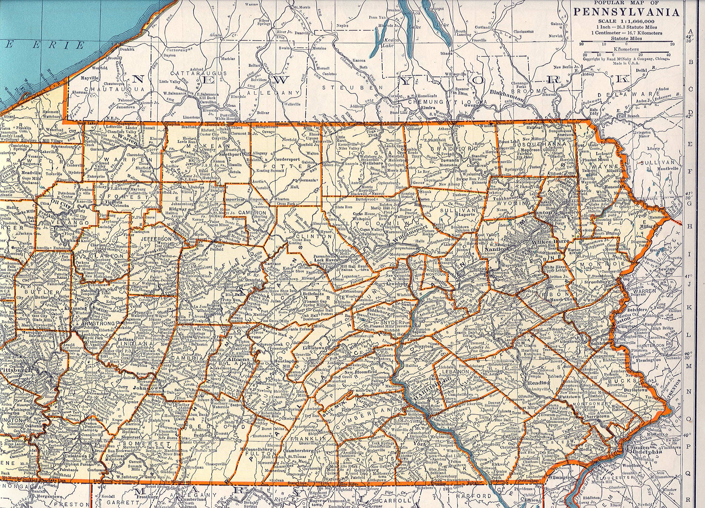
1940
PENNSYLVANIA. This map is believed to be from the
1940 Commercial Atlas of the World, Geographical
Publishing Co., Chicago. It has population by counties
and cities on the back, and a location index that matches
the grid around the edge. Scale: 1 inch = 15 miles. Size:
14.5 x 21 inches. |
 |
1941
DUQUESNE HUNTING AND FISHING MAP, published by the
Duquesne Brewing Co. of Pittsburgh, printed by Inland
Lithograph Co., Chicago, undated. The date of this map is
not known, it was seen for sale dated 1941 so that date
is used here, although it may be a little early. This
colorful advertising map has drawings of the wildlife
that can be hunted in each county. Only the center
portion is shown here. The company is now defunct. Its
brewery had an enormous clock on the side that was the
biggest in Pittsburgh and perhaps in the state. Blank
verso. Scale: 1 inch = 16 miles. Size: 26 x 35 inches. |
 |
1942
PROPERTY MAP OF HILLMAN COAL & COKE CO.
WASHINGTON MINE, CITY OF WASHINGTON & TWP. OF CANTON,
WASHINGTON COUNTY, PENNA. This is a mine map showing the
layout of a coal mine underground relative to surface
features and property divisions. No draftsman or engineer
is identified, although it apparently was prepared by the
coal company. The relative accuracy of maps like this has
become a major issue in several mine disasters. Scale: 1
inch = 500 feet. Size: 48 x 36 inches. |
 |
1943
PART OF NORTHEASTERN U.S.A., page 85 from Goode's
School Atlas by J. Paul Goode, 1943 edition,
published by Rand McNally & Co. This is a 286 page
school atlas; the Pennsylvania map is a two page spread
of the northeast, half shown here. Scale: 1 inch = 65
miles. Size: 10.5 x 8 inches. |
 |
1944
RAND MCNALLY POPULAR MAP OF PENNSYLVANIA, page 48 from an
unknown atlas, presumably from Rand McNally. A map of
Oregon is on the verso. Scale: 1 inch = 26 miles. Size:
11 x 14 inches. |
 |
1945
PHYSICAL MAP OF PENNSYLVANIA AND NEW JERSEY and POLITICAL
MAP OF PENNSYLVANIA AND NEW JERSEY , edited by L. Philip
Denoyer, published by Denoyer-Geppert Co., Chicago, 1945
edition. This is a large wall map with 2 maps on one
sheet. The top map is the
physical
one and the bottom map is the
political
one. Each map is on a scale of
1 inch = 8 miles, and each is about 31 x 44 inches. The
political map shows counties by color and names more
towns. |
 |
1946
CAMBRIA COUNTY, page 24 from My Pennsylvania - A
Brief History of the Commonwealth's Sixty Seven Counties,
published by the Commonwealth of Pennsylvania,
prepared and produced by the State Department of Commerce.
Although a history, this book resembles an atlas of the
state. Each county has two pages with a map of the county,
a photograph of the courthouse, and other photos and
historical information. The book also contains a state
map on the end plates, a short history of the state, and
pictures of each governor. Although largely a rural
county, Cambria contains the city of Johnstown which
requires it to have this large and impressive French
Empire style courthouse at Ebensburg. |
 |
1947
PENNSYLVANIA, copyright by C. S. Hammond & Co. N. Y.
There are insets of Philadelphia and Pittsburgh. This map
is undated but is believed to be from the 1947 edition of
World Book Encyclopedia. Only the southeast is shown here.
The altitude is color-coded, from green for the lowest
altitude through yellow and orange to red for the highest.
On the verso Pennsylvania towns are listed with
their population and location per the grid around the map
edge. Size: 10 x 13.5 inches. |
 |
1948
PENNSYLVANIA MINOR CIVIL DIVISIONS - TOWNSHIPS,
Department of Commerce, Bureau of the Census 1940, U.S.
Government Printing Office 1948. This black and white map
shows the outlines of all the townships and boroughs in
the state. Note they are broken out by number for
Delaware and Allegheny counties because there are so many.
Blank verso. Scale: 1 inch = 8 miles. Size: 27 x 42
inches. |
 |
1949
PENNSYLVANIA STATE CAPITOL GROUP, from Pennsylvania
Capitol Buildings Harrisburg, Pennsylvania, printed
by the state government, January 1949. This small
brochure or folder contains this map plus text on the
history and architecture of the Capitol Building. The
capitol was moved from Philadelphia to Harrisburg in 1812
and for a time met in the old Dauphin County courthouse.
The first capitol building was ready in 1822 and was
destroyed by fire in 1897. A second building was begun
and then razed as being not dignified enough. The present
grand structure, designed by architect Joseph Huston, was
completed in 1909 and enlarged in the 1980s. Today, the
building is perhaps better known for the murals lining
its chamber walls painted by Edwin Austin Abbey and
Violet Oakley. The map shows the capitol grounds as they
were in 1949. Nowadays, the buildings shown have other
uses and several newer buildings have been added. Size: 8
x 8.5 inches. |


