


| WELCOME | Articles on Historical Maps of Pennsylvania | WELCOME |
Pennsylvania in Old Geography Books 1900-1950
|
1900 Morton's Elementary Geography Pennsylvania Edition, by Eliza H. Morton, Butler, Sheldon & Company, New York, Philadelphia, Chicago, Boston. Copyright 1900 by Butler, Sheldon & Company. Although this 128 page book is dated 1900, the 8 page Pennsylvania addendum, described below, is dated 1901. The text contains 15 printed color maps and numerous black & white maps and illustrations which are a mixture of originals and photo reproductions. Pennsylvania is described on pages 55 , 56-57 , 59 . It is not clear if Eliza is a teacher or academic. She has this to say: "The Primary book should aim to furnish those who may never be able to enter the grammer school with a knowledge and an inspiration that shall lead them to study geography with profit and pleasure all their lives." This indicates the book may also be intended for home use, and that Eliza was perhaps an academic. The book is printed in letterpress relief with halftone illustrations. Size: 10 x 8.5 inches. |
|
STATES OF THE ATLANTIC SLOPE. This color map appears on page 54, and shows the region from Massachusetts to Florida. A regional map with this particular coverage is rare in geography books. It appears printed in relief, probably by a wax engraving plate with color from a line screen.Text on the verso. Scale: 1 inch = 160 miles. Size: 9 x 7 inches. |
|
(1901) PENNSYLVANIA. Struthers, Servoss & Co., Engr's, N.Y. This double page map appears in the anonymous Pennsylvania addendum to Morton's geography, which has this title page and is copyright 1888, 1901 by Butler, Sheldon & Co. The state description follows on pages 4-5 , 6-7 , 8 . Page 4 has a state relief map. This five color map shows the county seats in bold face and only a few other towns. It is tipped into the binding to lay flat when opened. It is probably from a wax engraving. This section contains relief illustrations probably also from wax engravings. Scale: 1 inch = 25 miles. Size: 7.5 x 12.5 inches. |
|
1901 The Rand-McNally Primary School Geography, by James A. Bowen. Illustrated by diagrams, colored maps, and engravings, prepared expressly for this work. Chicago and New York: Rand, McNally & Company. Revised Edition 1901. The first edition was in 1894 according to the copyright, and all the maps are dated 1894. This 128 page textbook has 17 single page and two double page colored maps, several partial page maps, and numerous black & white engravings and photo reproductions. Pennsylvania is part of the Middle Atlantic States section on pages 62 , 64-65 , 66 . The accompanying map on page 63 is described below. There are sections at the back devoted to Hawaii, the Philippine Islands, Porto Rico, and Cuba; all under United States control at the time. Text, illustrations, and maps are all printed in relief probably from wax engraving plates. Size: 9.25 x 8 inches. |
|
MIDDLE ATLANTIC STATES. Copyright, 1894, by Rand, McNally & Co. This simple map includes the region from New York to Virginia. A few towns are named, major river systems indicated as well as mountains by hachures. A simple map for a primary school text. The map was printed in at least two passes with the color from screened lines, probably from wax engraving plates. Scale: 1 inch = 110 miles. Size: 8 x 6.25 inches. |
|
1905 The New Eclectic Series Elementary Geography, New York . Cincinnati . Chicago. American Book Company. Copyright 1883 by Van Antwerp, Bragg & Co., Copyright 1896 by American Book Company; however, tables at the back have 1905 population. No author is given for this 82 page textbook for young children. It contains several color maps and numerous black and white illustrations that were originally wood engravings, some with the engraver identified. Pennsylvania is included in the Middle States description on pages 29, 31, and 32. Text, illustrations, and maps are all printed in relief probably from stereotypes and wax engraving plates. Size: 9.75 x 7.75 inches. |
|
THE MIDDLE STATES. Russell Hinman, Del. This map is page 30 in the above text and likely originally dates from the 1880s. Hinman is identified as the maker of all the maps and most, but not this one, also have the imprint of Matthews, Northrup & Co., Sc. Buffalo, N.Y. Hinman was also an author of several geographies, see 1898. This map includes the region from New York to Virginia with an inset of the New York City area at top left. A few towns are named, major river systems indicated as well as mountains by hachures. The map was printed in at least two passes with the color from screened lines, probably from wax engraving plates. Scale: 1 inch = 89 miles. Size: 8 x 6.25 inches. |
|
1906 Frye's First Steps in Geography, by A.E. Frye, Ginn & Company. Copyright 1906 by Alexis Everett Frye. Frye styles himself as First Superintendent of Schools of Cuba, of all places. His name is also seen as Alex in some books, probably to eliminate gender confusion. Frye was a prolific writer of textbooks from the 1890s to around 1920. This is a 172 page book with an 8 page supplement of statistics. There are 24 full page color maps and several partial page color maps, along with numerous black & white maps and illustrations. The sections on the states appear towards the end, with Pennsylvania described on pages 148 , 150-151 , 152 . The entire book, including maps and illustrations, is printed in relief probably from electrotype, or wax engraving, plates. Size: 10.25 x 8.25 inches. |
|
MIDDLE ATLANTIC STATES. This map is on page 149 from Frye's geography described above. The states included are New York, Pennsylvania, New Jersey, Maryland, Delaware, Virginia, and West Virginia. There are small insets of the United States and Long Island at upper right. A few towns are indicated, along with the major river systems; the mountains are crudely shown. The map is printed in relief and is probably a wax engraving; the color is printed from line screens. The latitudes of foreign cities are shown along the sides. Longitude west from Greenwich, with text on verso. Scale: 1 inch = 85 miles. Size: 8.5 x 6.5 inches, with the southern tip of Virginia extending beyond the map boundary. |
|
1906 Geography Primer Philadelphia Edition, by Oliver P. Cornman and Oscar Gerson, both of the Philadelphia school system. Philadelphia and New York, Hinds, Noble & Eldredge, copyright 1905, 1906. This is a 136 page textbook intended for young readers. It contains a 22 page section on Philadelphia in the front and a 13 page section on Pennsylvania described below. There are four color maps (World, United States, and the ones described below), and many black & white illustrations, which are halftone reproductions of photos. Size: 8 x 6 inches. |
|
NEW ENGLAND AND MIDDLE STATES, Peters, Engrs. Boston. The Middle States include Virginia and West Virginia on this simple map, which appears to be a wax engraving. The verso is text. Scale: 1 inch = 220 miles. Size: 6 x 4 inches. |
|
PENNSYLVANIA. Peters Engrs., Boston. This map appears as pages 126, 127 in Chapter XI, titled Pennsylvania. The remaining pages are 125 , 128-129 , 130-131 , 132-133 , 134-135 , 136-137 . Page 130 has an additional relief map. This map is tipped in so it lies flat when open and appears to be a wax engraving. The printed color scheme shows the counties with each county seat named. Text on verso. Scale: 1 inch = 36 miles. Size: 6 x 9 inches. |
|
1910 New Geographies Second Book Part One, By Ralph S. Tarr and Frank M. McMurry. New York The Macmillan Company 1910. Set up and electrotyped. Norwood Press, J. S. Cushing Co. - Berwick & Smith Co. Norwood, Mass. U.S.A. This 440 page book has many color maps, black and white photos, and illustrations. Pennsylvania is included in the Middle Atlantic section which begins with the double map shown below and continues on pages 49, 50-51, 52-53, 54-55, 56-57, and for several more pages. Printed in relief from electrotype (wax engraving) plates with halftone photos. Size: 9.5 x 7.5 inches. |
|
RELIEF MAP OF THE MIDDLE ATLANTIC STATES Modeled by Edwin E. Howell; and MIDDLE ATLANIC STATES Williams Engraving Co., N.Y. These maps are page 48 and Figure 64 in the above geography. The Middle States include Virginia and West Virginia here. The verso of the color map is blank and similar color maps throughout the text appear to have been separately printed and inserted during binding. Scale: 1 inch = 100 miles. Size: 8 x 5.5 inches. |
|
FIG. 89. MAP TO SHOW THE LOCATION OF NEW YORK CITY, PHILADELPHIA, AND BALTIMORE. Williams Engraving Co., N.Y. This map follows page 66 in the Middle Atlantic states section which extends to page 70. Philadelphia and New York City are shown at larger scale in the insets at the bottom. Blank verso. Scale: 1 inch = 62 miles. Size: 8 x 5.5 inches. |
|
1912 Maury's New Complete Geography, Penn. & N. J. Edition, by M.F. Maury, LL.D. Revised. American Book Company, New York. Copyright 1880, 1893, 1895, 1898, 1899, 1906 by the University Publishing Company, New York. This book uses 1910, 1911 census data, and a "Recent Geographical Events" page has a 1912 date. This is a 180 page text with about 30 color maps, and numerous black & white photos and illustrations. Matthew Fontaine Maury (1806-1873) is considered one of the fathers of modern oceanography and rates a page in Wikipedia. His name continued on books long after his death as this example shows. At the back is a 35 page supplement titled Lessons in Commercial Geography, followed by a 10 page addendum on Pennsylvania titled: Geography of Pennsylvania, by Martin G. Brumbaugh, Professor of Pedagogy in the University of Pennsylvania. This addendum is exactly the same as the one in the 1898 Redway & Hinman geography also included here. This is followed by a 6 page addendum on New Jersey. A description of Pennsylvania, along with some pictures, is on pages 44 , 45 , 46 , and 47 . The book is printed in letterpress relief. Size: 12 x 10 inches. |
|
MIDDLE ATLANTIC STATES NORTHERN DIVISION. This map appears on page 43 of Maury's geography; the color is laid down by a screen of lines. It shows Pennsylvania, New York, and New Jersey with little detail. There are small insets at the bottom of Philadelphia, New York City, and Long Island. The map appears printed in relief, probably from a wax engraving. The verso is text. Scale: 1 inch = 50 miles. Size:10.5 x 8.5 inches. |
|
1913 King's Geographies Advanced Geography Pennsylvania Edition, by Charles F. King, Master of the Dearborn School, Boston. New York Charles Scribner's Sons 1913. The copyright date is 1906, so that was probably the first edition date. Across the top of the title page is "King's Concrete Geographies;" however, this one appears made mostly of paper. This is quite a large text with 290 pages plus a 15 page addendum plus a 16 page Pennsylvania supplement described below. There are printed color maps and numerous small black and white maps and photo illustrations. The description of Pennsylvania in the main text is on pages 91 , 92 , 94-95 , 96 . There is a political map of the Middle Atlantic states on page 90 ,and a physical map of the same region on page 93 described below. Printed in relief with relief halftone photos. Size: 11.5 x 9.5 inches. |
|
PHYSICAL MAP OF MIDDLE ATLANTIC STATES, The Matthews-Northrup Works, Buffalo. This printed color map appears on page 93 of the King geography. There is an inset of the New York City area at upper left, and the map runs to the page edge at three points. The region from New York to Virginia is included. Printed in relief, likely from wax engraving plates. Scale: 1 inch = 72 miles. Size: 9.5 x 7.5 inches. |
|
PENNSYLVANIA. This anonymous map appears on pages 8-9 of the Pennsylvania addendum titled Geography of Pennsylvania by George Morris Philips, A.M., Ph.D., LL.D., Principal State Normal School, West Chester. The remaining text is shown on the following pages: 1 , 2-3 , 4-5 , 6-7 , 10-11 , 12-13 , 14-15 , 16 . There are additional maps of Philadelphia and Pittsburgh on page 3, and many black & white photos. The map is printed in relief, probably from wax engraving plates. Scale: 1 inch = 24 miles. Size: 9.5 x 13 inches. |
|
1916 Roddy's Complete Geography, Edition for New Jersey and Pennsylvania, by H. Justin Roddy, M.S., Ph.D., Department of Geography, First Pennsylvania State Normal School. American Book Company, New York. Copyright 1902, 1913, 1915 by American Book Company. Revised to 1916. This 144 page book has a 16 page Pennsylvania and New Jersey addendum. There is no indication which of the several normal schools Roddy was affliated with, but he apparently considered it "First." A short description of the state appears on page 45 , following the map described below. In addition to color maps, the book has numerous black & white illustrations printed in relief halftone. Most are created from photographs, but some appear to be original drawings. The addendum is titled Geography of Pennsylvania by Martin G. Brumbaugh, Ph.D., Professor of Pedagogy in the University of Pennsylvania; and is exactly the same as the addendum in the 1898 Redway & Hinman geography included here, although it is copyright to 1913. Printed in letterpress relief. Size: 12.5 x 10 inches. |
|
MIDDLE STATES. E. Y. Farquhar, Del. L.L. Poates, ENGR. N.Y. This map appears on page 42 of Roddy's geography described above. It is printed in relief and in color in multiple passes, probably from wax engraving plates. The region from New York to Virginia is covered, with insets of the tip of western Virginia, New York City, and Long Island. A few towns are named and the major rivers shown. Some care is taken to show the mountains by hachures. Longitude is west from Greenwich with GMT noon time at top; the verso has text. The latitude of some foreign cities is shown along the side. Scale: 1 inch = 62 miles. Size: 10.5 x 8.25 inches. |
|
1921 New Geography Book Two Pennsylvania Edition, By Wallace W. Atwood, Ginn and Company, Boston. Copyright 1920 by Ginn and Company. The maps are dated 1921 and the Pennsylvania addendum is dated 1922, so a compromise date of 1921 is used here. The book is labeled as the Frye-Atwood Geographical Series, so Atwood apparently took over part of A.E. Frye's textbook empire. Like the King geography above which it resembles, this is a very large 300 plus page textbook with a 28 page Pennsylvania addendum. It has many color maps and numerous black and white maps and photo illustrations.There is a Middle Atlantic states map on page 35, described below, which concludes a section titled "Southern Division of the Appalachian Highlands" that covers pages 26-27 , 28-29 , 30-31 , 32-33 , 34 , 36-37 , and includes Pennsylvania. Pages 32-33 have bird's eye view topographical maps of Pittsburgh and Philadelphia that are a feature of this geography; unfortunately, they are printed in black and white. The text is printed in relief with relief halftone photos. Size: 11.5 x 9.5 inches. |
|
MIDDLE ATLANTIC STATES POLITICAL AND ECONOMIC MAP, Redfield - Kendrick - Odell Co., N.Y. This printed color map appears on page 35 of the Atwood geography, and runs to the page edge at a couple points. The region from New York to Virginia is included. Unusual features are a listing of military camps, and arrows showing imports-exports at the three main ports of New York City, Philadelphia, and Norfolk. Printed in relief, likely from wax engraving plates. Scale: 1 inch = 77 miles. Size: 9.75 x 7.75 inches. |
|
PENNSYLVANIA POLITICAL MAP SHOWING NATURAL REGIONS. L.L. Poates Co., N.Y. Map Plate Patented July 5, 1921. Method of Making Maps Patented July 5, 1921. Despite the patented method, this looks like a map from wax engraving plates. It appears on pages 2-3 of the Pennsylvania addendum titled The State of Pennsylvania by Grace A. Turkington. Copyright 1922 by Ginn and Company. This large addendum is a small textbook unto itself; and reproduced here in its entirety: 1 , 4-5 , 6-7 , 8-9 , 10-11 , 12-13 , 14-15 , 16-17 , 18-19 , 20-21 , 22-23 , 24-25 , 26-27 , 28 . There are additional small black and white maps and many photos throughout the text. The map is printed in relief on two separate pages, probably from wax engraving plates. Scale: 1 inch = 17 miles. Size: 10.5 x 17 inches. |
|
1921 Dodge's Advanced Geography Pennsylvania Edition, By Richard Elwood Dodge, Professor of Geography, Teachers College, Columbia University. Rand McNally & Company Chicago. Copyright revised 1921. The original copyright was in 1904, and Dodge created a geographical series of six books to cover all grades. The text is organized by topographical, rather than political region, and Pennsylvania is included in a chapter titled "Middle States of the Atlantic Coast" on pages 129-141: 129 , 131 , 132-133 , 134-135 , 136-137 , 138-139 , 140-141 . The map on page 130 is described below. This book has about 355 pages plus a Pennsylvania addendum also described below. There are many color maps and numerous black & white maps and photos. Printed in relief with halftone photos. Size: 10 x 8 inches. |
|
MIDDLE ATLANTIC STATES. Copyright Rand, McNally & Company. This color map is Fig. 215 on page 130 of Dodge's geography. It includes the states from New York to Virginia. Printed in relief probably from multiple wax engraving plates. Scale: 1 inch = 95 miles. Size: 8 x 6 inches. |
|
PENNSYLVANIA. Fig. 2. A political map of Pennsylvania. Copyright 1906 by Rand, McNally & Company. Revised, 1912. This map appears on pages 2-3 of the addendum at the back of Dodge's book titled: The Geography of Pennsylvania by Charles H. Albert, Professor of Geography, State Normal School, Bloomsburg, Pennsylvania. Copyright 1905 by Rand, McNally & Co. Revised, 1914. At 36 pages, this is one of the largest Pennsylvania sections seen in a geography; and is too long to include more than the first few pages: 1 , 4-5 . The two page map is tabbed to lay flat and printed in color, to emphasize the counties, from wax engraving plates. Scale:1 inch = 24.5 miles. Size: 8.25 x 13 inches. |
|
1921 Geografia Superior Illustrada de Appleton, ....bajo la direccion del Doctor Juan Garcia Puron, D. Appleton and Company 1921. This is a 160 page Spanish language textbook 'arreglada expresamente para los paises Hispanoamericanos.' Appleton's Higher Geography was apparently used as the model or basis for this version. There are many black and white illustrations and a few color maps. Latin America is treated in a bit more depth than the rest of the world. There is a United States map, but no state or regional maps. Pennsylvania, like the other states, is given a short paragraph on page 29. Printed in relief, the many illustrations appear to be wood engravings printed from a stereotype plate. Size: 12 x 10 inches. |
|
ESTADOS UNIDOS. This anonymous map is a color wax engraving. Rivers are shown and a few towns are named. Scale: 1 inch = 500 kilometers. Size: 6 x 10 inches. |
|
1922 The Geography of Pennsylvania, by Zoe A. Thralls, Department of Geography, State Normal School, Indiana, Pennsylvania. The MacMillan Company, New York 1922. This 110 page book has a brown paperback cover with a double page map described below. There are numerous black & white photos and illustrations printed in both relief and halftone screen throughout the letterpress text. The entire book is on Pennsylvania and there is no Table of Contents, so the first page text is shown here. The institution of the author is now known as Indiana University of Pennsylvania, and is the largest school in the State System of Higher Education, although it probably no longer has a Department of Geography. Size: 10 x 8 inches. |
|
PENNSYLVANIA. Williams Engraving Co., N.Y. This anonymous map from Thralls is a three color wax engraving, with the colors denoting elevation. Counties and towns are named; and railroads, canals and a few highways shown. Scale: 1 inch = 24 miles. Size: 8.5 x 13.5 inches. |
|
1922 Human Geography - Book Two - Regions and Trade, by J. Russell Smith, Ph.D. Professor of Economic Geography, Columbia University. The John C. Winston Company Philadelphia. This book is dated 1922 at front, however the Pennsylvania addendum described below is dated 1923, and a printer's mark indicates it may have been printed in 1925. The book has 434 pages with a 37 page appendix titled Mathematical Geography, which includes astronomy along with data tables. At the back is a 42 page Pennsylvania addendum described below. There are thirty-two color maps, numerous black & white maps and photos. The text is organized according to topography rather than political boundaries as illustrated by the Table of Contents and page 118 introducing the North Atlantic Coast District. Pittsburgh is described on pages 154-155 as part of the Eastern and Central Uplands. The text is printed in relief and the photos in halftone. Size: 10 x 7.5 inches. |
|
PHYSICAL AND POLITICAL MAP OF MIDDLE ATLANTIC STATES. Copyright, The John C. Winston Co. This undated map appears on page 119, and a similar two-page map of the entire northeast appears on pages 124-125 . There is an inset of Long Island at top and the colors indicate elevation. The maps are printed in relief probably from multiple wax engraving plates. Scale: 1 inch = 70 miles. Size: 8 x 5.75 inches. |
|
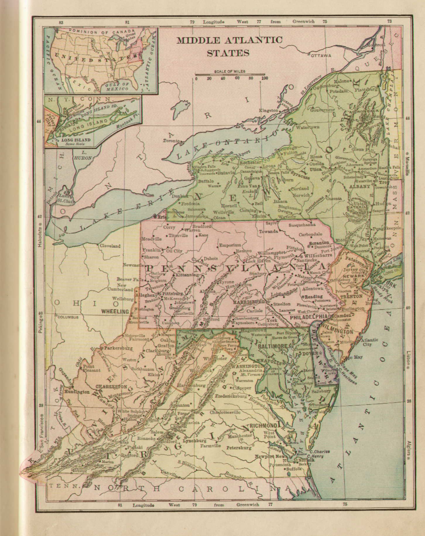
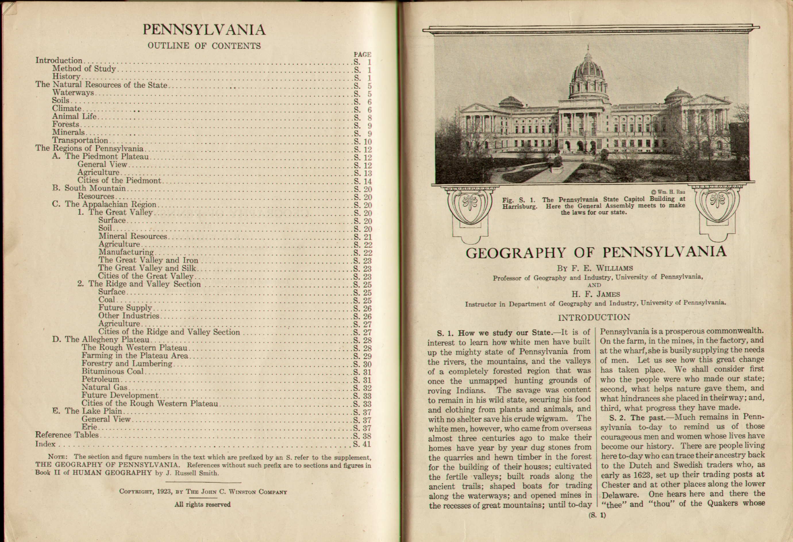
(1923) Geography of Pennsylvania, by F.E. Williams Professor of Geography and Industry, University of Pennsylvania, and H.F. James Instructor in Department of Geography and Industry, University of Pennsylvania. This long 42 page supplement contains the two-page state map shown here, and the text coverage is indicated by the Table of Contents . There are several smaller black and white maps illustrating topology, population, climate, and industry data. This map is split and printed separately on two pages probably from wax engraving plates. The color is a combination of screen lines and direct printing and indicates elevation. Scale: 1 inch = 27 miles. Size: 8 x 12 inches. |
|
1922 Goodes School Atlas Advance Pages, By J. Paul Goode, Ph.D. Professor of Geography, University of Chicago. Published by Rand McNally & Co. This is a 32 page preprint of maps for the forthcoming Goode's School Atlas as described in the preface. A further description is on pages v, vi-vii, viii, giving the raison d'etre for the atlas and the table of contents. The pages are not consecutively numbered but go up to 95; the published first edition in 1923 had 96 pages. There are several United States maps, but no Pennsylvania regional map. This is an original preprint of (what became) a famous school atlas; for a later edition, see 1943 below. Printed in relief with the maps probably from wax engraving plates. Size: 11 x 9.5 inches. |
|
UNITED STATES OF AMERICA - PHYSICAL AND POLITICAL. Rand McNally & Company. This map is pages 30-31 of Goode's preprint. Some other interesting US maps are shown on pages 28-29. All the maps are blank verso double page, and tipped into the binding for flat display. Scale: 1 inch = 190 miles. Size: 10 x 16 inches. |
|
1923 Practical Map Exercises and Syllabus In American History, By Mildred C. Bishop and Edward K. Robinson. Copyright, 1922, by Ginn and Company; The Double Book Binding Patented April 3, 1923. This school workbook contains about 15 black and white outline maps, like the one below, for students to trace. In the back (inside the "Patented Double Binding") is a sheaf of onion skin pages to be traced and colored. Each map is directed at a historical event with accompanying text and directions; and the use is described in the preface. These workbooks were usually the child's to keep, and were not handed in at end of term like textbooks. Printed in relief. Size: 11 x 8.75 inches. |
|
VII. THE WAR OF 1812 IN THE NORTH AND EAST. Copyright by Ginn and Company. This map, shown with accompanying text page, is the largest scale map of Pennsylvania in the above book. It shows the Middle Atlantic region in outline and the student's onion skin tracing is also shown. The most important event in the War of 1812 was either the sack of Washington D.C., apparently the reason for using this map, or the Battle of New Orleans - "In 1814 we took a little trip along with Colonel Jackson down the mighty Mississip. We took a little bacon and we took a little beans, and we caught the bloody British in the town of New Orleans." Scale: 1 inch ~ 100 miles. Size: 7.5 x 9.75 inches. |
|
1924 Rabenort's Geography Grade 7A The United States as a Whole. By William Rabenort, A.M., Ph.D. Principal of Public School 55, The Bronx The City of New York. American Book Company, New York. This is a later edition as the original copyright is 1914. "This book describes in bold outlines the forms of life and nature which characterize the United States as a whole." This 212 page text for seventh graders has a large number of United States maps, like the one below, but no regional maps. It is organized as a physical, rather than political geography, and its approach can be shown by the first few pages of Chapter VI on Minerals: 90-91, 92-93, 94-95; which mention Pennsylvania and show the type of maps and illustrations. The text is printed in relief and the photos in halftone. Size: 8.5 x 5.75 inches. |
|
UNITED STATES. This anonymous two page map appears in the front of Rabenort's textbook. In the back is a sheaf of continental maps that are similar and bear the mark of L. L. Poates Eng. Co., N. Y. These colored maps are printed in relief probably from multiple wax engraving plates. Scale: 1 inch = 300 miles. Size: 7 x 9 inches. |
|
1925 Essentials of Geography Second Book Part One Revised Edition, with Pennsylvania Supplement, by Albert Perry Brigham and Charles T. McFarlane. American Book Company New York. Copyright 1916, 1920, 1925. This is a 234 page textbook with a Pennsylvania addendum described below. The first edition apparently appeared in 1916; although this book is copyright to 1925, the addendum is dated 1927. It contains 24 full page color maps and numerous black & white maps and illustrations. The 'Second Book Part One' refers to the book covering only North America in the author's scheme of things, and appears intended for high school students. Pennsylvania is covered in the Middle Atlantic states section which includes the map described below. The state is treated more explicitly on pages 91 , 92-93 , 94 , including small black & white maps of Philadelphia and Pittsburgh. The text is printed in letterpress relief and the illustrations are halftone reproductions of photos. Size: 10 x 8 inches. |
|
PHYSICAL AND POLITICAL MIDDLE ATLANTIC STATES, copyright by American Book Company. The Matthews-Northrop works, Buffalo, N.Y. Here the Middle Atlantic states include only New York, Pennsylvania, and New Jersey. The color scheme denotes elevation. Printed in halftone relief. Scale: 1 inch = 62 miles. Size: 8.5 x 6.25 inches. |
|
(1927) PHYSICAL AND POLITICAL PENNSYLVANIA, The Matthews-Northrop works, Buffalo, N.Y. This map appears in the 32 page Pennsylvania addendum titled Geography of Pennsylvania by J. Russell Smith and Joseph H. Willits; only the title page of which is shown here. This addendum is copyright from 1916 up to 1927. This map is printed separately on two pages, apparently by halftone relief. Scale: 1 inch = 24 miles. Size: 8.5 x 13.5 inches. |
|
1933 The Geography of Pennsylvania, by H. Harrison Russell, State Teachers College, Bloomsburg, Pennsylvania. New York The MacMillan Company 1933. This is an 80 page textbook with a brown paperback cover. There is a two page color state map in front and numerous black & white maps, photos, and illustrations throughout the text. There is also a two page color map of the northeast in the back. This text was apparently prepared as an addendum to a more general textbook; a note on the first page says: "Prepared primarily for use as a supplement to accompany Huntington, Benson, McMurray's Living Geography." There is no Table of Contents. The book was probably printed using offset lithography. Size: 10 x 8 inches. |
|
PENNSYLVANIA POLITICAL AND PHYSICAL MAP. Williams Engraving Co., N.Y. This map from Russell's geography was printed from a relief plate using a lined screen for the color, and very likely printed separately from the text. Scale: 1 inch = 23 miles. Size: 8.5 x 13.75 inches. |
|
1934 Geography - United States and Canada, by Harlan H. Barrows, Professor of Geography and Chairman of the Department of Geography, University of Chicago, and Edith Putnam Parker, Assistant Professor of the Teaching of Geography, University of Chicago. Copyright 1925, 1931, 1934 by Silver, Burdett and Company, New York. This 286 page book covers only the region in the title with 13 pages of color maps and numerous black and white maps and photos. It accompanies another book for young children titled Journeys in Distant Lands by the same authors. The text here is organized as a journey between major cities and Pittsburgh is described on pages 220-221 , 222-223 . In the back is a section on Scattered American Lands, including Alaska, Hawaii, the Panama Canal Zone, the Philippine Islands, and Porto Rico. Canada is given a small twelve pages. Printed in relief with halftone photos. Size: 10.25 x 8 inches. |
|
NORTHEASTERN UNITED STATES. General Drafting Co. Inc. N.Y. This is the largest scale map showing Pennsylvania in the Barrows-Parker book and appears on pages 170-171. It is split and printed separately on two pages in relief, probably from wax engraving plates. There is a black & white map in the exercise section at the back of the book showing much the same area. Scale: 1 inch = 110 miles. Size: 8.5 x 12.5 inches. |
|
1935 The Pupil's Workbook in the Geography of Pennsylvania, by George Elberon Harding, Professor of Geography, State Teachers College, California, Pennsylvania. Ginn and Company, Boston. Copyright 1930, 1935. The first edition was apparently in 1930, and the subject matter is given in the Table of Contents . This 66 page workbook was not intended to accompany any particular textbook. It contains a great number of black & white maps which the student is suppose to fill in for various studies, such as the location of petroleum fields in the example shown. "The modern trend in teaching geography is toward the presentation of fewer facts as such and a more definite emphasis upon relationships." There are no illustrations. Printed in relief. Size: 8 x 10 inches. |
|
RELIEF MAP OF PENNSYLVANIA by Edward B. Harden. Besides the blank maps, there are three other maps of the state in this workbook, the most interesting of which is this relief map, with an elevation scale at bottom. It is a halftone reproduction of a photo of another map. This is the same relief map that appeared in the 1900 Bien state atlas. Scale: 1 inch ~ 50 miles. Size: 6 x 8.5 inches. |
|
1937 North America and South America, by G. R. Bodley and E. L. Thurston, Iroquois Publishing Company, Syracuse, New York. This 245 page textbook was both copyrighted and printed in 1937, but is believed a later edition of an earlier book. It combines both the political and physical approaches to geography with sections on land forms and particular regions such as the Appalachian Highland on pages 40-41, 42-43, 44-45, 46-47. There are many illustrative maps like the one below, and black and white photographs. Printed in relief with halftone photos. Size: 11 x 8.5 inches. |
|
THE MIDDLE ATLANTIC STATES SHOWING NATURAL PRODUCTS AND LEADING EXPORTS. This map appears on page 38 of the above text and is typical of the many maps throughout. This one shows state products and appears to indicate that nothing is made in the middle of Pennsylvania; which is not true, of course. Scale: 1 inch ~ 100 miles. Size: 9 x 6.75 inches. |
|
1939 Geography of Pennsylvania, by Lawrence C. Davis, Head, Department of Geography, State Teachers College, Indiana, Penna. Silver Burdett Company New York 1939. This 100 page textbook contains the map described below and numerous other black & white maps and photo illustrations, all printed using halftone screens. The map is printed in relief probably from a halftone relief plate. Since the entire book relates to Pennsylvania, only the Table of Contents is shown here. There is no preface to state the author's intentions, but the book appears intended for the middle school grades: "What does Pennsylvania mean to you? Does it mean forests and farmlands rolling over rounded uplands to a cloud banked far horizon, as it does to many girls and boys..." This author is from the same school and department as the author of the 1922 book above. Size: 10 x 8 inches. |
|
PENNSYLVANIA. This anonymous map from Davis is printed in five colors by halftone screen, with the colors denoting elevation. Counties and towns are named, and railroads and canals shown, although by this time the canal era was largely over. Scale: 1 inch = 25 miles. Size: 8.25 x 13 inches. |
|
1940 Geography In Human Destiny, Overseas Edition For The Armed Forces, By Roderick Peattie, Original Maps And Charts Drawn by Arthur H. Robinson. Copyright 1940 by George W. Stewart. Published by arrangement with the publisher George W. Stewart, New York. Editions for the Armed Forces, Inc. New York. This handy 256 page paperback book was made for servicemen, one of a series as shown by this list. The intention of this book is explained on the back cover; and in the table of contents. The small size indicates it was intended to be carried and not for the classroom, and the maps, like the one below, are only explanatory. From the level of discussion, Peattie's original book of 323 pages (also published circa 1940 and reprinted in 1970) was intended as a college level text. Printed in relief on cheap paper and probably on high volume presses. Size: 4 x 5.5 inches. |
|
FIG. 21. THE CORN BELT. This small map taken from the Department of Agriculture appears on page 183 of the above book in a section titled (curiously enough): 'The Modern Economic Region Has Psychologic Character.' It is typical of the maps scattered through the text for illustration purposes. Arthur H. Robinson (1915-2004), who supplied the maps, is one of the few American cartographers who became well known. He was Professor in the Geography Department at the University of Wisconsin from 1947 until retirement, and a prolific writer on cartography who rates a page in Wikipedia. Scale: 1 inch ~ 1000 miles. Size: 2.5 x 4.25 inches. |
|
1941 The Little Geography Of The United States, By Mable Pyne. Houghton Mifflin Company, Boston. Copyright 1941 by Mable Pyne. This 36 page large format book for very young children appears intended for general sale. It contains cartoon type maps some of which include a piece of Pennsylvania. The inside covers have double page maps of the United States. Appears to be offset printing. Size: 13 x 10 inches. |
|
OUR MOUNTAINS. This map on page 9 of Pyne's book is one of the figurative maps in the text which shows Pennsylvania. Size: 13 x 10 inches. |
|
1943 Pennsylvania A Regional Geography, by Raymond E. Murphy and Marion Murphy, School of Mineral Industries, The Pennsylvania State College, Copyright by The Pennsylvania Book Service, Harrisburg, 1937. Second Printing 1943. This is a 600 page college introductory text with numerous partial page black & white maps and pictures, all printed in relief halftone, color is not used anywhere. Since the entire book is about the state, the Table of Contents is shown here on pages ix , x . Printed in letterpress relief. Size: 9.5 x 6.25 inches. |
|
FIG. 3. PHYSIOGRAPHIC DIAGRAM OF PENNSYLVANIA. This is one of only a few full page maps in the above text, all in black and white. It was printed from a relief plate, however prepared. No scale. Size: 4.5 x 7 inches. |
|
1943 Goode's School Atlas Physical, Political, and Economic for American Schools and Colleges Revised and Enlarged By J. Paul Goode. Ph.D. Late Professor of Geography University of Chicago.1943 Edition Rand McNally & Company. Goode's atlas was first published in 1923 (see the original preprint for 1922 above) and quickly assumed the position Mitchell's atlas had occupied in the nineteenth century; that is, it became the standard school atlas. There were many subsequent editions, and sometime around 1960 it was renamed Goode's World Atlas. It is still being published (as of 2005) by Rand McNally. As indicated, this edition was published after Goode's death (1862-1932); and he rates a short article in Wikipedia. This 286 page book is strictly an atlas, the only text is the author's preface and the gazetteer at the back. The preface is titled "To the Student and Teacher" and is shown here along with some following pages: xi , xii-xiii , xiv-xv , xvi-1 , 2-3 . Goode was especially interested in map projection and devised the Goode Interrupted Homolosine projection; page 2 illustrates this interest. Printed from relief plates. Size: 11.25 x 9.75 inches. |
|
PART OF NORTHEASTERN U.S.A. Rand McNally & Company, Chicago. This color map appears on pages 84-85 of Goode's atlas and is the largest scale map in the atlas showing Pennsylvania. It covers the northeast and part of the midwest, a cutoff Maine to most of Virginia and west to a cutoff Illinois. The coloring indicates elevation. Printed from multiple relief plates. Scale: 1 inch = 64 miles. Size: 10 x 16.5 inches. |
|
1947 Using Our Earth, By Gertrude Whipple and Preston E. James. Cartography by Arthur H. Robinson. The Macmillan Company, New York 1947. This 290 textbook is for young children. It is printed in large type with kodachrome prints throughout and contains illustrative maps by the (later) well known cartographer Robinson. It is organized around themes, illustrated here by a section on roads on pages 208-209, 210-211, 212-213. Appears to be offset printing with color halftones. Size: 9.25 x 7 inches. |
|
The maps in the above book are illustrated here by the untitled maps on pages 282-283 shown at left. They were prepared by the cartographer Robinson for this text. Robinson later became well known for his writing on cartography, see 1940 above. |
|
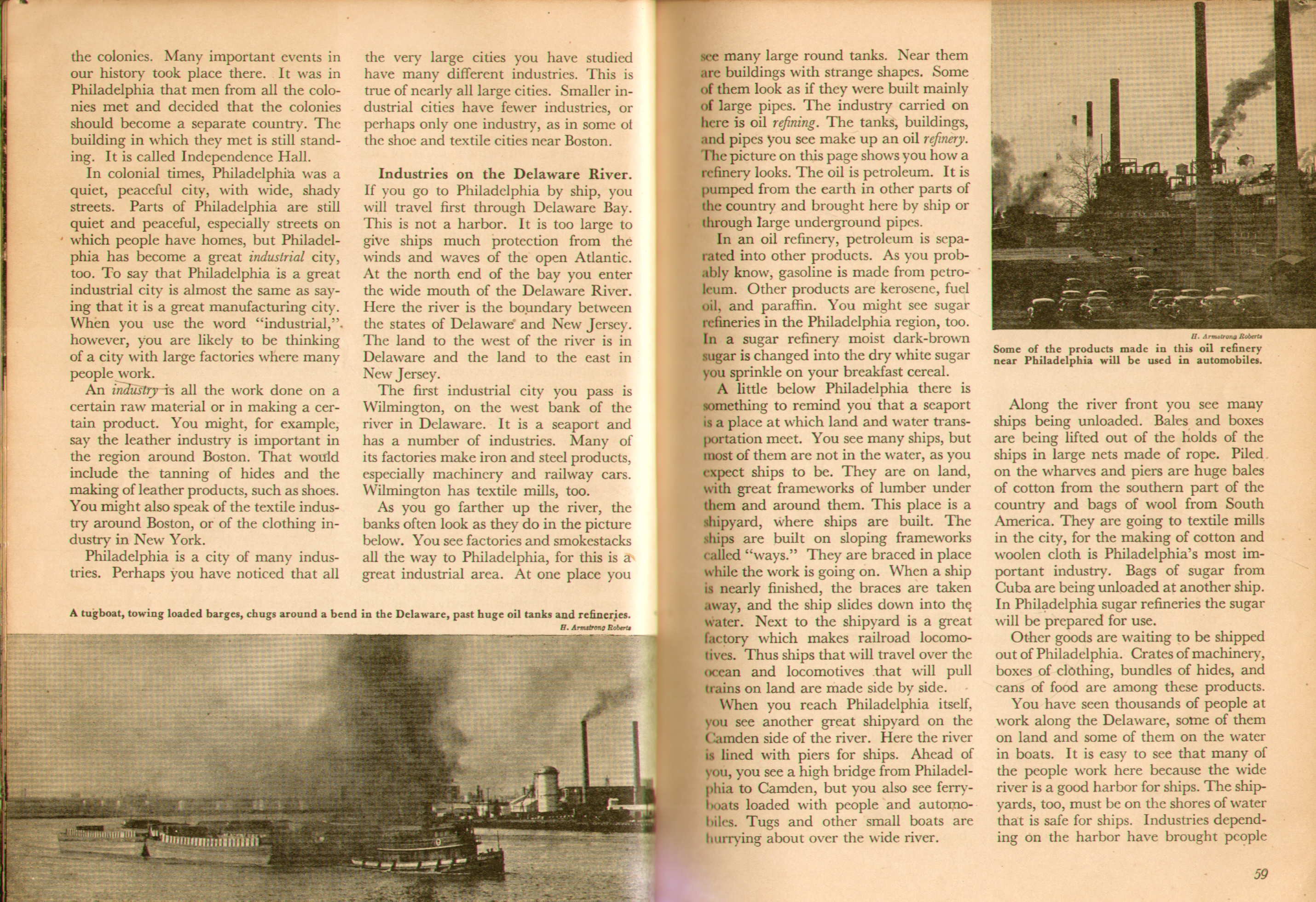
1948 Geography of the Americas, W.R. McConnell, Professor of Geography in Miami University, Oxford, Ohio. Art Cartography in Topographical Maps by Valdemar Paulsen. Copyright 1945 by Rand McNally & Company Edition of 1948. This is a 410 page book organized along topographical, or geological lines, so descriptions of Pennsylvania tend to be scattered through the text. The most succinct discussion appears in a section titled "The Allegheny Plateau" on the following pages: 86-87 , 88-89 , 90-91 . There is a section on cities which includes the following pages on Philadelphia: 56-57 , 58-59 , 60 . The map on page 57 is an example of the topographical drawing contributed by Paulsen. Other maps are described below. The text is printed in relief with halftone photos. The illustrations extend to the edge of the page with no margin. Size: 10 x 8 inches. |
|
MIDDLE ATLANTIC STATES. A physical-political map of the Middle Atlantic States. Rand McNally & Company, Chicago. This map is on pages 42-43 of McConnell's book and is the largest scale Pennsylvania map. Another smaller scale map is on page 38 titled 'Eastern States Physical-Political.' The maps are printed in relief from multiple plates to obtain the coloring. Scale: 1 inch = 71 miles. Size: 9 x 8.25 inches. |
|
1953 Exploring Pennsylvania, by Sylvester K. Stevens, Ralph W. Cordier, Florence O. Benjamin, Maps by Harold Faye. Harcourt, Brace and Company, New York, Copyright 1953. This 625 page tome was prepared for the general public and not as a textbook. Its extensive Table of Contents appears on pages: v , vi-vii , viii-ix , x-xi ,There are small scale black and white maps scattered through the text, as well as illustrations and photos printed by halftone. The only place color is used is on the cover. The text is printed letterpress relief. Size: 9.25 x 7 inches. |
|
(UNTITLED) This rudimentary map appears at the end of the above book. It is a split page map and so was printed along with the text. The shading was created with halftone dots and the map lines and text have a relief look, probably printed from a halftone relief plate. Scale: 1 inch = 30 miles. Size: 7 x 11.75 inches. |
|
1955 The First Golden Geography, A Beginner's Introduction to Our World, A Little Golden Book, by Jane Werner Watson, pictures by William Sayles. Golden Press New York. Copyright 1955 by Golden Press Inc. This is a 24 page book for very young children, not intended for school use except maybe in kindergarten. The only maps are really illustrations as shown by this view of North America. Although golden books started earlier, this may be a first edition for this title. As its number, 534, might indicate, it was a late addition to the canon. Golden books were ubiquitous in households with children in the 1950s, 60s, 70s. Printed by offset lithography with halftone color screens. Size: 8 x 6.5 inches. |
Copyright 2009 by Harold Cramer.
All rights reserved.
Revised March, 2010: September, November, 2013.