The early 1950's official map covers were
among the most attractive issued.
 |
1950
Here is a cover with a proclamation from the Governor
stating what a superb job he is doing. |
 |
1951
If Governor Fine's administration did nothing else, it
issued official road maps from 1951 to 1954 with very nice cover
designs. This is a drawing of the state seal with the
motto: Virtue, Liberty, and Independence. A better job
could have been done on the bird. |
 |
1951
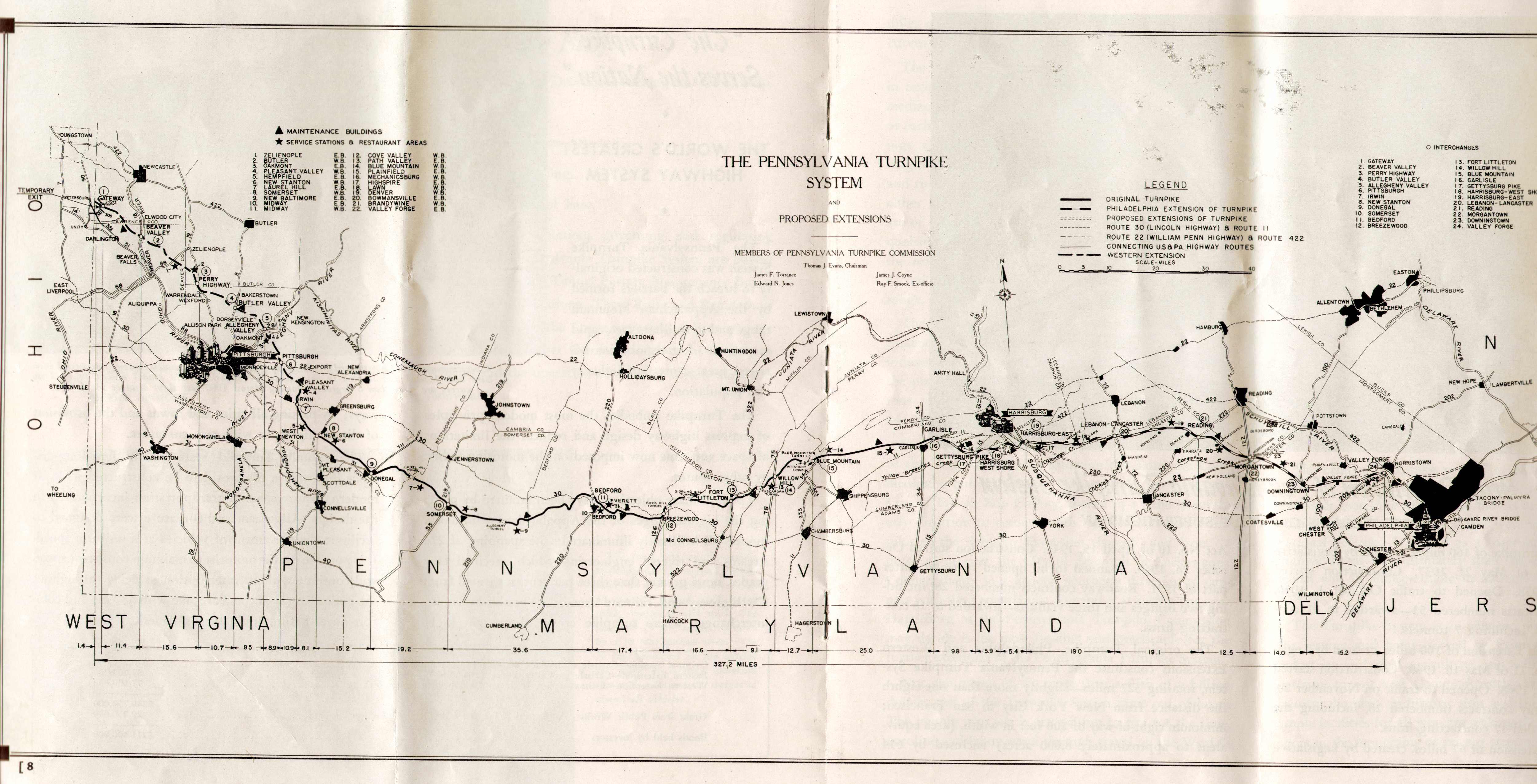
Pennsylvania Turnpike System The Worlds Greatest Highway, published by the Pennsylvania Turnpike Commission, Harrisburg, Fifth Printing October 1951. This is a 16 page booklet about the turnpike with a 2 page 9.5 x 18 inch map in the center and a mailer label on the back. The inside map may have been issued separately.
|
 |
1952
This cover, and the one for 1953, appear to have the same
artist as the 1949 cover. |
 |
1952
Pennsylvania Turnpike System The Worlds Greatest Highway, published by the Pennsylvania Turnpike Commission, Harrisburg. This is a 16 page booklet about the turnpike with a 9.5 x 22 inch foldout map in the center; most of which is shown. This item is very similar to the 1951 issue and also has the mailer label. The inside map has the date "Rev. March 1952," and seems to have been issued separately in several date revisions, and this separate issue may have begun in 1951.
|
 |
1953
Again, a very nice cover design on this official map. |
 |
1953
Pennsylvania Turnpike System, published by the Pennsylvania Turnpike Commission, Harrisburg. Although it has a cover change, this 16 page booklet is similar to the 1951 and 1952 ones above; and is also a mailer. The foldout map in the center is the same as in the 1952 booklet with the note "Rev. March 23 1953."
|
 |
1953
Pennsylvania Turnpike System The World's Greatest Highway, published by the Pennsylvania Turnpike Commission, Harrisburg. This booklet has an alternate cover, but the pages and the map inside are the same as above. Apparently, it was an alternate issue for 1953 or intended for 1954.
|
 |
1954
And another one. This is a drawing of the state flag. The
flags of all the states and territories line the grand
walkway approaching Mount Rushmore. The
Map Image
shows the 'state' of state
cartography. This map was also issued with Governor Leader's imprimatur. |
 |
1954
Welcome to the Worlds Greatest Highway Penna Turnpike. Pennsylvania Turnpike Commission. This 9.5 x 22 inch map, most of which is shown here, is undated. John S. Fine (1951-55) is governor, and there is reference to a 1954 opening of the Delaware River Extension, so it probably dates to 1954.
|
 |
1955
George Leader became governor in January, 1955, and then became a successful operator
of nursing homes after leaving the governorship. This is
the last cover with the colonial pitchman. |
 |
1955
Welcome to the Worlds Greatest Highway Penna Turnpike. Pennsylvania Turnpike Commission. This 9.5 x 22 inch map has Leader as governor and was probably issued in 1955. Except for the cover, it is very similar to the 1954 map shown above.
|
 |
1955
Pennsylvania Turnpike System Penna Turnpike. Pennsylvania Turnpike Commission. This 16 page booklet has the same foldout map inside as the 1954 map and the separately issued 1955 map above. It appears to have been issued late in 1954 or early in 1955 while Fine's man (Edward L. Schmidt) was still Secretary of Highways. There are two nearly identical versions, the second coming later, possibly dating to 1956, and apparently issued solely so Leader's new Secretary of Highways (Joseph J. Lawler) could get his name on it.
|
 |
1956
This map commemorated the 250th anniversary of Ben
Franklin's birth, 1706. |
 |
1956
Welcome to the World's Greatest Highway Penna Turnpike. Pennsylvania Turnpike Commission. This birds eye view of pike and fields is one of the prettiest state maps issued. Undated, but thought to be the 1956 map, Leader (1955-59) is governor. The 15.5 x 16.5 map inside is similar to the 54/55 map but with changes.
|
 |
1957
This 1957 map is dated
1956 and is otherwise identical to that map except for
the cover design. |
 |
1957
Welcome to the World's Greatest Highway Penna Turnpike. Pennsylvania Turnpike Commission. This 1957 map is dated; the map inside is the same as the 1956 map shown above.
|
 |
1958
The state (unfortunately) began a period of ugly sideways
covers with this map. It also is the first cover to use a
photo. |
 |
1958
Your Guide to the ... Pennsylvania Turnpike. Pennsylvania Turnpike Commission. Undated, but thought to be the 1958 map by comparison to the one below. This 8.5 x 23 inch brochure has an 8.5 x 11 inch simplified map.
|
 |
1959
The photos used on map covers were routinely awful. David
Lawrence controlled the Democratic political machine in
Pittsburgh and used it to vault into the governorship
during a period of Philadelphia political weakness. He is
credited (by some) with initiating the Pittsburgh cleanup
of the 50's. |
 |
1959
Your Guide to the ... Pennsylvania Turnpike. Pennsylvania Turnpike Commission. Undated, but David Lawrence (1959-63) is governor, so believed to be the 1959 map. This brochure is similar to the one for 1958, but the map is somewhat different.
|