The 1970's continued photo
map covers except for the attractive 1976 Bicentennial cover.
 |
1970 |
 |
1971
|
 |
1971
Penna Turnpike, Pennsylvania Turnpike Commission. This 11 x 17 inch brochure has a Rand McNally map dated 1971. |
 |
1972
Again, a truly awful photo and cover design. |
 |
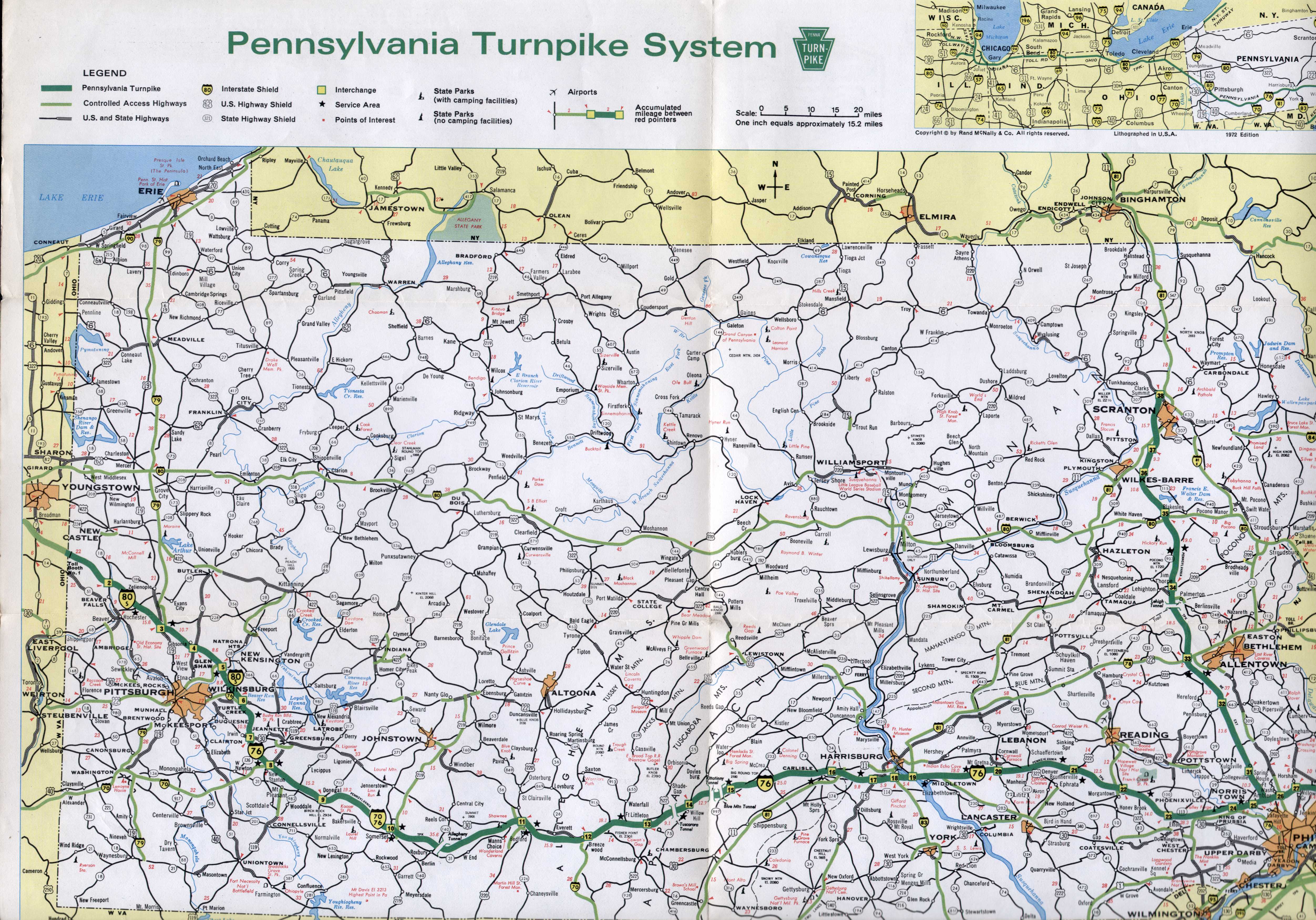
1972
Penna Turnpike "The Bicentennial Highway", Pennsylvania Turnpike Commission. Dispite what is on the cover, this 16 x 18 inch brochure has a Rand McNally map dated 1972 . It is more detailed than the previous ones and similar to a commercial Rand McNally state map. |
 |
1973
|
 |
1973
Penna Turnpike The Bicentennial Highway, Pennsylvania Turnpike Commission. This brochure is very like the previous one except the Rand McNally map is dated 1973. |
 |
1974
|
 |
1974
A second 1974 map was issued titled 'Fishing and Boating
Map Special Issue'. |
 |
1974
Pennsylvania Turnpike, Pennsylvania Turnpike Commission. This undated brochure was put out during the Shapp years and so is dated 1974 here as no other turnpike item for that year has been seen. There is no map inside, just some colored lines to figuratively represent the pike. |
 |
1975
This is a picture of Independence Hall in Philadelphia;
finally, no concrete. |
 |
1975
There's nothing like the Pennsylvania Turnpike, Pennsylvania Turnpike Commission. This 12 x 16 inch brochure has an uncredited Rand McNally map that is code dated to 1975. |
 |
1976
The state managed to get a really good cover design for
the Bicentennial. This map also has a larger folded size,
about 9 x 5 inches, instead of 9 x 3 inches. |
 |
1976
There's nothing like the Pennsylvania Turnpike, Pennsylvania Turnpike Commission. This is the actual bicentennial map expanded to an 18 x 23 inch size. It has a larger (and credited) Rand McNally map dated to 1976, and surrounded with small maps of the interchanges. |
 |
1977
Apparently Pittsburgh complained about all the
Philadelphia related covers lately. |
 |
1977
Penna Turnpike, Pennsylvania Turnpike Commission. This 12 x 18 inch brochure is a redesign and now has a dated General Drafting map. |
 |
1978
|
 |
1978
Penna Turnpike, Pennsylvania Turnpike Commission. This brochure is similar to the 1977 one except for the cover picture, and is believed to be a 1978 issue. |
 |
1979
No official map issued; the state began issuing official maps
every two years. Shown here is a Pennsylvania Turnpike Commission map. This brochure is identical to the 1978 one except Richard Thornburg (1979-87) is now listed as governor, and so this is a 1979 issue. |