


| WELCOME | 1680's Pennsylvania Maps | WELCOME |
The founding counties of Pennsylvania - Philadelphia, Bucks, and Chester - were created in 1682. Penn created three counties in his new province in order to balance the existing three Delaware counties of New Castle, Kent, and Sussex that were created under the Duke of York's proprietorship. Chester County was formed from a portion of the existing New Castle County. Today, the city and county of Philadelphia are one and the same, the only such arrangement in the state. The county seat of Bucks County is Doylestown, and of Chester County, West Chester. In 1789 Delaware County along the river was carved out of Chester County with the odd result of placing the town of Chester (the Swedish Uplandt) in Delaware County.
In the Whipple Museum of the History of Science, Cambridge, there is a fifteen inch globe by Morden, Berry, and Lea, London, dated to 1683, for which the British Library also has an uncut sheet of gores. Pennsylvania is named and this is the first appearance of the state on a globe. Both the globe and gore sheet are illustrated in Pritchard & Taliaferro.
A map titled CARTE DE LA LOUISIANE OU DES VOYAGES DU SR. DE LA SALLE...., par Jean Baptiste Louis Franquelin, 1684 Paris, shows the eastern United States plus the Caribbean islands, and appears to be the earliest French map to include Pennsylvania.
| 1680.1 CAROLINA, VIRGINIA, MARYLAND, AND NEW IARSEY. This map is listed in Dunlap, and appeared on page 379 in Geography Rectified, by Robt. Morden, London 1680 (Burden #523). The map extends north to the 40th parallel and so includes southeastern Pennsylvania with no detail. | |
| 1680.2 A NEW MAP OF VIRGINIA AND MARYLAND, by Robert Morden, this map is page 369 in Morden's Geography Rectified published in London, 1680 (Burden #522). The coverage extends north past 40 degrees and so includes a strip of southern Pennsylvania. | |
| 1680.3 THE NORTH WEST PART OF AMERICA, by Robert Morden, another map in Morden's Geography Rectified published in London, 1680 (McCorkle #680.6, Burden #520). The coverage extends from Greenland down the northeast coast far enough south to include Chesapeake Bay. Delaware Bay and New York are named but nothing in Pennsylvania and the area is a blank. Why Morden calls it the 'northwest' is unclear, although it is northwest from London. A map of the same name, but a different engraving, appears in later editions of Morden's Geography Rectified. | |
|
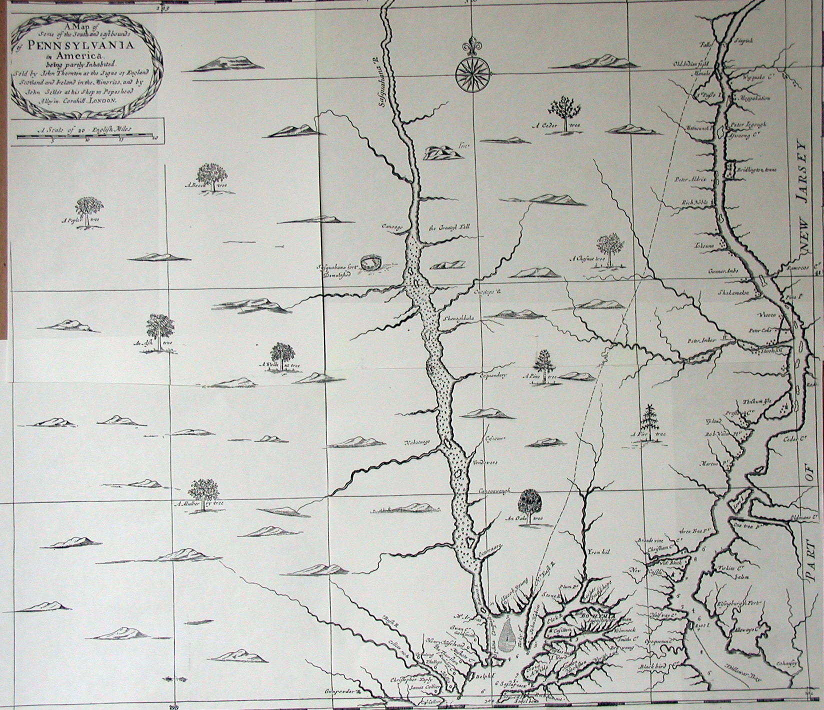
1681.1 A MAP OF SOME OF THE SOUTH AND EAST BOUNDS OF PENNSYLVANIA IN AMERICA BEING PARTLY INHABITED, SOLD BY JOHN THORNTON......AND BY JOHN SELLER....., LONDON. See the discussion in the Introduction about this map, considered the first map of Pennsylvania. Its dating and importance was not recognized until 1923 by Ford and few copies exist. There is a reproduction of a portion in Soderlund from an original at The Historical Society of Pennsylvania, and it was reproduced in their journal, The Pennsylvania Magazine of History and Biography, in 1924 which is the image shown here. It is also reproduced in Burden #541. The southeast part of the state is shown with the 40th parallel at the bottom and the line of 40d 30m through the middle. At top right is the 'SkooleKil' at about 40d 40m. The map thus has the 40th parallel about 40 miles too far south. The map identifies many landowners, towns, and features around the Chesapeake and Delaware Bay; the idea being to show potential settlers (and land buyers) they were not entering a wilderness; but three fourths of the map shows empty land so buyers can see the enormous amount of land for sale. The copy of this map in the British Library is in A collection of Mr. - Seller's Four Books of sea-charts & draughts, and there are four columns of text describing Pennsylvania underneath. The same map is included in the Blathwayt Atlas, see Black. A high resolution image of the map may be seen at Lower Merion Maps, the website of the Lower Merion Historical Society. |
| 1681.2 FLORIDA, from A New Geography by Jonas Moore (Burden #538). This map is essentially a copy of the Duval map 1660.3 of similar name. The map extends to 40 degrees north and Lake Erie appears too far south. The Pennsylvania region is labeled "Nation of Chat." Burden says the maps in Moore's book were engraved by Herman Moll. | |
| 1682.1 A CHART OF THE SEA COASTS OF NEW ENGLAND NEW IARSEY VIRGINIA MARYLAND & CAROLINA FROM C. COD TO C. HATTARAS, By Iohn Seller. This map is from John Seller's Atlas Maritimus or a Sea-Atlas describing the Sea-Coasts in most of the known parts of the World, by John Seller, Hydrographer to the King. London. Printed by A. Godbid and J. Playford for John Seller, and are to be sold by him at his house at the Hermitage at Wapping, and at his shop on the West-side the Royal Exchange, 1682. This edition is sometimes called a miniature or pocket version of the Atlas Maritimus. This map (McCorkle #682.3, Burden #549) can be seen at MapForum.Com , Issue 2 in the checklist. Although not named in the title, 'Penselvania' is named on the map. Along with the New Jersey map below, this is believed to be the second appearance of the name Pennsylvania on a printed map. This map is a smaller and cruder version of the folio map that appeared in the Atlas Maritimus of 1675. The same map appears in Seller's Hydrographica Universalis published circa 1690. | |
|
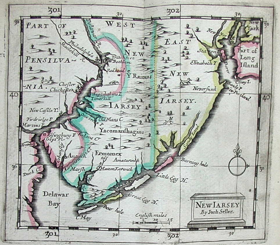
1682.2 NEW IARSEY, by John Seller, from the Atlas Maritimus of 1682 as described above. It shows the Delaware Bay and River north to above Philadelphia, which is named along with 'Chefter' and 'New Castle T.' This is the first appearance of Philadelphia on a printed map, preceding the Holme map of 1683. Southeastern Pennsylvania is called 'Part of Pensilvania.' In the same edition of Atlas Maritimus is a map titled VIRGINIA AND MARYLAND (Burden #551) which extends north to 40 degrees and so includes a strip of southern Pennsylvania, which is not named. This image is from the 1690 edition of Seller's A New System of Geography, which contains exactly the same map, and is courtesy of the Darlington Memorial Library, Pittsburgh. Burden (#600) dates this map to 1684 on the presumption the Atlas Maritimus copies containing it were actually issued after the title page date of 1682. |
| 1682.3 CARTE DE L'AMERIQUE SEPTENTRIONALE ET PARTIE DE LA MERIDIONALE DEPUIS L'EMBOUCHIERE DE LA RIVIERE ST. LAURENS..., a large manuscript map of eastern North America attributed to Franquelin and dated to circa 1682. This map is No. 4 in Brown, who reproduces the northwest quadrant extending from Hudson Bay to Virginia and west to the Mississippi. The original is in Paris but a manuscript copy is in the Library of Congress. Johnson (1974) reproduces the same map. | |
| 1682.4 LA FLORIDE Par N. Sanson d.' Abbeville Geogr' Ordre. du Roy. This map (Burden #546) appears in Curieuse Aenmerckingen der bysonderste Oost en West-Indische from Joannes Ribbius, Utrecht 1682. It shows the region below 40 degrees latitude west to beyond the Mississippi. Lake Erie is too far south and "Virginie" is named. The map is based on the circa 1650s Sanson maps with no improvements. | |
|
1683.1A PORTRAITURE OF THE CITY OF PHILADELPHIA IN THE PROVINCE OF PENNSYLVANIA IN AMERICA, by Thomas Holme Surveyor General. Sold by Andrew Sowle in Shoreditch, London; printed in A Letter from William Penn Proprietary and Governour of Pennsylvania in America, to the Committee of the Free Society of Traders, London 1683, see the discussion in the Introduction. The pamphlet was reproduced by James Coleman in 1881, which is the image here, also reproduced in Burden #557. Sometimes considered the first map of Pennsylvania, it shows the planned layout of Philadelphia, the first planned town in the country. Penn wrote the letter during his visit to America from October, 1682 to August, 1684. The Society of Free Traders was a joint stock company organized in 1682 to invest in Pennsylvania. Penn welcomed the capitol to get his colony up and running and granted the Free Traders special privileges. This was resented by the Pennsylvania Assembly which refused to approve the company's charter. Hence it had no legal status in the state other than as a land owner and eventually disbanded, see Soderlund. This map is reproduced and discussed in Fite & Freeman and is commonly found in map histories. The numbers on the map refer to a list of names of land buyers. Penn concocted a complicated scheme of land purchase. Anyone buying land would be given a town lot in Philadelphia of a size corresponding to his land purchase. Unfortunately, Penn was unable to acquire enough riverfront land from previous settlers to make Philadelphia large enough for his purposes. This layout of Philadelphia as originated by Holme was not completely built up until the nineteenth century. For biographical information on Holme, see Hough and Corcoran. |
|
1683.2 Weslager mentions a manuscript map titled CAERTE VAN DE SUID RIVIER dated circa 1683 and contained in the manuscript of the journal of the second voyage of Jasper Danckaerts, which is archived at the Long Island Historical Society. This is long after Dutch authority in the region ended. The map shown here is a facsimile which appeared in the Memoirs of the Long Island Historical Society Vol. I 1867. The map accompanies Journal of a voyage to New York in 1679-80, by Jaspar Dankers and Peter Sluyter. It shows a section of the Delaware River below the falls near Trenton. |
|
1683.3 CANADA OU NOVVELLE FRANCE by Alain Manesson-Mallet from his Description de l'univers, Paris 1683 (McCorkle #683.3, Burden #565, 611). This small scale map shows the northeast from Greenland to Virginia. There is no detail in the Pennsylvania region and the state is not named. The image shown here is from the 1684 German edition Beschreibung des ganzen Welt-Kreisses published by Johann David Zunners, which is identical to the French except for the text in German at the top. Pennsylvania is called Novelle Svede and New York is called Hollande. There was another German edition in 1719 which can be seen at Pugsley Maps from McGill University. The color on this copy is not original. Longitude appears to be east of Ferro. Blank verso. Scale: 1 inch = 600 miles. Size: 5.5 x 4 inches. |
| 1683.4 VIRGINIE DE L'AMERIQUE. This is a small map by Mallet from his Description de l'univers. It shows the Chesapeake Bay area from Hatteras to above the 40th parallel, and so includes southeastern Pennsylvania, which is not identified. The area is called New France. The map is listed in the Maryland State Archives as Map #183M5, also in Burden #567, 613. There is also a map titled FLORIDE (Burden #568, 614) which shows the region south of about the 40th parallel and west to the mouth of the Mississippi on the Gulf coast. The area that would be Pennsylvania is blank and contains the title cartouche. These maps also appeared in the German edition of Mallet. | |
|
1683.5 LE CANADA, OU NOUVELLE FRANCE, &C. TIREE DE DIVERSES RELATIONS DES FRANCOIS, ANGLOIS, HOLLANDOIS, &C, PAR N. SANSON DE ABB.& GEOGR. ORDRE. DU ROY. by Nicolas Sanson and originally from Geographische en Historische Beschryvingh, Utrecht 1683 (McCorkle #683.6, Burden #575). This small map, first published in 1657, is also found in several later publications as given by McCorkle. The image here is from Introductio ad Geographiam novam et veterem... by Joannis Luyts, Utrecht 1692, engraved by A. de Winter. It shows the northeast and Canada with the St. Lawrence and the Great Lakes in the center. The scale is small and Pennsylvania is not named though the Swedish colony is identified; the towns of Gustaveburg and Christina appear in New Sweden. This copy of the map carries a faint image underneath which can be seen. Apparently the map was folded while still wet with some ink transfer. Longitude west from either Ferro or Paris, blank verso. Scale: 1 inch = 210 miles. Size: 8.25 x 12 inches. |
|
1683.6 CANADA OF NIEW VRANKRYK GETROKKEN UIT VERSCHEIDE FRANSCHE, ENGELSCHE, EN HOLLANDSCHE BESCHRYVINGEN ENZ. by Nicolas Sanson from a Dutch edition (McCorkle #683.5). This is a Dutch edition of the Sanson map listed above, and Pennsylvania and Maryland are not named. The map was first published in 1657 with a French title, LE CANADA, OU NOUVELLE FRANCE (Burden #325), and Burden says this Dutch version was published by Joannes Ribbius in L' Amerique en Plusieurs Cartes, Utrecht 1683. Only the title is in Dutch, all the map terms are in French. The map shows the east coast from Newfoundland to Carolina, and the Swedish "Chriftian" is identified. A Delmarva peninsula division line, which first appeared on a 1656 Sanson map, can be seen. Blank verso, longitude apparently east from Ferro. Scale: 1 inch = 215 miles. Size: 8 x 11.5 inches. |
|
1683.7 DRAUGHT OF YE SUSQUEHANNES RIVER & HOW SOON YE INDIANS WESTWARD CAN COME HERE, dated September 7, 1683. A manuscript map of the Susquehanna River, the original is apparently in the Franklin D. Roosevelt Library. It comes from the records of Robert Livingston, an agent in New York who dealt with the Iroquois and other Indians. These records were reproduced as The Livingston Indian Records, in the journal Pennsylvania History, Volume XXIII No. 1, January 1956. An image of the top and bottom of the map with text is shown here. |
| 1684.1 A MAP OF Y.E ENGLISH EMPIRE IN Y.E CONTINENT OF AMERICA VIZ VIRGINIA MARY LAND CAROLINA NEW YORK NEW IARSEY NEW ENGLAND PENNSYLVANIA. W. Binneman sculpsit. Sold by R. Morden at ye Atlas in Cornhill neer y.e Royal Ex-chang & by W. Berry at y.e Globe near Charing Cross London. This map by R. Daniel first appeared circa 1679 (McCorkle #679.1, Burden #514). In this version the map was altered to include Pennsylvania. A 1712 version is illustrated at MapForum.Com , Issue 14. The main map shows the coast from the Chesapeake north. A small inset map shows the southeast coast. The map is illustrated in Pritchard & Taliaferro #69 Custis Atlas. | |
|
1684.2 AFTEYKENIGE VAN DE STADT PHILADELPHIA IN DE PROVINCIE VAN PENN-SYLVANIA IN AMERICA NA DE COPIE LONDON IN INTNEDER DUYS LAETEN SYNDEN DOOR JACOB CLAUS. G. DROGENHAM, FEC. Penn published his A Letter from William Penn... in Amsterdam in 1684. The Philadelphia map is reduced in size with other small changes from the 1683 edition. This image is a modern facsimile. Listed in Phillips page 698, Burden #581. |
| 1684.3 PAS KAART VAN DE ZEE KUSTEN VAN VIRGINIA TUSSCHEN C. HENRY EN T HOOGE LAND VAN RENSELAARS HOEK, by Claes Jansz Vooght. This map is a Dutch version of Hermann's 1673 map and appeared in the Joannes Van Keulen atlas De lichtende Zeefakkel (Burden #588). There is a 1692 version and a still later 1717 version is reproduced in Papenfuse & Coale, who discuss its history. The map includes southeastern Pennsylvania. Dunlap dates this map 1690. | |
|
1684.4 (Northeast) This manuscript map by one William Hack is reproduced in Hulbert's photographic collection of American manuscript maps in the British Library, which is the image shown here. The map is dated 1684 and covers the east coast from Virginia to Nova Scotia, only the southern part is shown here. 'Pennsilvania' is prominently marked on the Delmarva Peninsula. There is a companion map for the southeast. |
|
1684.5 A map titled CARTE DE LA LOUISIANE OU DES VOYAGES DU SR. DE LA SALLE...., par Jean Baptiste Louis Franquelin, 1684 Paris, shows the eastern United States plus the Caribbean islands, and so it is a stretch to include it here. However, it deserves mention as being the earliest French map seen to include Pennsylvania. The map is listed on page 563 in Phillips and appears in Volume 63 of the Jesuit Relations. The image here is a detail from a facsimile held by the Library of Congress. Pennsylvania lies on the Chesapeake Bay, there is no Maryland and an enormous Virginia. La Salle was an active French explorer of the Mississippi River Basin, and much of the French knowledge of interior North America came from his expeditions. |
| 1684.6 ABRIS DER STADT PHILADELPHIA IN DER PROVINZ PENSYLVANIA IN AMERICA, from Beschreibung Der in America neu-erfunden Provinz Pensylvania, Hamburg 1684. Penn published a German version of his A Letter from William Penn... in Hamburg. The Philadelphia map was redrawn although it is the same size as the Dutch version above, #1684.2. Both can be seen in M. P. Snyder, Figures 2, 3; also in Burden #583. | |
|
1685.1 NOVI BELGII NOVAEQUE ANGLIAE: NEC NON PARTIS VIRGINIAE TABULA MULTIS IN LOCIS EMENDATA per Nicolaum Visscher. This is a later version of the map of the northeast originally published by Jansson (Burden #305) in 1651, then by Visscher in 1655 and 1656 (Burden #315). This image is from the Library of Congress where it is dated Amsterdam?, 1685. Pennsylvania is named on the map. This map is sometimes dated circa 1690, for example both Dunlap and Van Erman so date it. It is reproduced in Pritchard & Taliaferro #11 dated circa 1684. The maker very likely refers to Visscher's son of same given name. |
| 1685.2 A NEW MAP OF NEW ENGLAND. NEW YORK. NEW IARSEY. PENSILVANIA. MARYLAND. AND VIRGINIA. Sold by Iohn Thornton at ye Platt in ye Minories. By Robt. Morden at the Atlas in Corn-hill. And by Phillip Lea at ye Atlas & Hercules in the Poultry. London. This map is of uncertain date (McCorkle #680.4, Phillips page 671 dated 1690?) and a later state was dated 1686 by the British Library. The map is illustrated in Pritchard & Taliaferro #70 Custis Atlas and in Burden #616 dated 1685. The date of 1685 is given by Stevens and Tree (Tooley, Chapter 2) with subequent editions circa 1686, 1690, 1715-20. The later editions bear George Willdey's imprint. This map is illustrated in Swift (2001) where it is dated 1704. The Willdey version may be seen at the Darlington Library where it is dated circa 1690. One of the interesting things about it is the 40th parallel goes through New Castle Town, used as a reference point in defining Penn's grant. | |
| 1685.3 THE ENGLISH EMPIRE IN AMERICA BY R.B. The R. B. is a pseudonym for the publisher Nathaniel Crouch and the map appears in a book of the same name published in London in 1685 (McCorkle #685.1, Burden #605). It shows the coastline from Maine to Carolina severely distorted to fit on a vertical page. Philadelphia and 'Pensilvania' are named and 'Bridlinton', later renamed Burlington in New Jersey. A German edition of the map and book appeared in 1697 with the map titled Das Englische America. | |
| 1685.4 A NEW MAP OF THE ENGLISH EMPIRE IN THE CONTINENT OF AMERICA, VIZ. NEW ENGLAND, NEW YORK, NEW IARSEY, PENSILVANIA, MARYLAND, VIRGINIA, AND CAROLINA. by John Thornton, Robert Morden, Phillip Lea. This is a title page for an apparently unpublished map (see McCorkle #685.3 and Burden #616 for discussion) which has a huge title cartouche imposed over a map of the 'Lake Erius or Fells' region. An accompanying sheet is the first state of map 1685.2. There are two other maps in the set that do not show Pennsylvania. | |
|
1685.5 NOVI BELGII NOVAEQUE ANGLIAE NEC NON PENNSYLVANIAE, ET PARTIS VIRGINIAE TABVLA by Justus Danckerts. The dating of this map is uncertain (McCorkle #680.2). Sometime circa 1670-80 Danckerts published a derivative of the Jansson-Visscher maps which of course did not include Pennsylvania. This 1685 State 2 version is illustrated at MapForum.Com , Issue 14, where the State 1 map is dated circa 1673. This map is sometimes seen dated in the 1690's. Size: 18 x 21.5 inches. Image from the the Heritage Map Museum CD by permission. |
| 1685.6 A NEW MAP OF VIRGINIA MARYLAND AND THE IMPROVED PARTS OF PENNSYLVANIA & NEW JERSEY, sold by Christopher Browne at the Globe near the West End of St. Paul's Church, London. This map is #86 in Stevens and Tree (Chapter 2 of Tooley) and dated circa 1685. There was another issue circa 1700. John Senex revised it in 1719 and published it in A New General Atlas in 1721 (McCorkle #719.7, Phillips page 671). The early version of the map is shown in Papenfuse & Coale, and a comparison of the titles for the three versions also appears there. Only southeastern Pennsylvania is shown and settlements along the Delaware and Susquehanna Rivers are named. This is one of the earliest maps (perhaps the earliest) to show a boundary line between Maryland and Delaware. The 1719 version is reproduced in Stephenson & McKee. The map appears in Burden #694 dated circa 1692. | |
| 1685.7 A MAPP OF VIRGINIA, MARY=LAND, NEW=JARSEY, NEW=YORK & NEW ENGLAND. by John Thornton at the Sundyall in the Minories and by Robert Green at ye Rose and Crowne in Budgrowe. This map is a later version of 1678.1 altered to show Pennsylvania and Philadelphia. This map is #88 in Stevens and Tree (Chapter 2 of Tooley) which lists two early versions circa 1673-80 and this later one circa 1685. It shows the coast from the Chesapeake to the Hudson. A small inset map shows New England. Both the Chesapeake and the Delaware are shown in considerable detail and accuracy as on Hermann's map. This map is shown as #673.2 in McCorkle, though McCorkle is refering to the earlier state. The only apparent difference in the states are added names. | |
| 1685.8 (Chesapeake Bay) Mathews, page 259, lists a manuscript map under this date showing Maryland and Delaware with part of Pennsylvania and New Jersey, chiefly Chesapeake and Delaware Bay, and says a reproduction appears in the Facsimiles of B. F. Stevens as #1237 in Volume 12. Stevens lists the map as being in the Auckland Manuscripts at Kings College, Cambridge, and offers no date; however by inference he would date it to the Revolutionary period. The map shows only the southeastern tip of Pennsylvania and names Lancaster, Chester, and Philadelphia. It is likely that Mathews is mistaken and the map dates later. | |
| 1685.9 A LARGE MAPP OF VIRGINIA, MARYLAND, PENSYLVANIA, EAST AND WEST NEW JERSEY, & NEW YORK, by John Thornton. This map is dated 1682 at the Maryland State Archives (Map #182T5), however the earliest date of appearance noted seems to be in a Thornton edition of the Atlas Maritimus of 1704. It is thought to have been made between 1682 and 1685 and the later date is used here as more reasonable. This is considered the first version of another map (1701.2) of similar title issued circa 1701. | |
|
1685.10 (Southeastern Pennsylvania) This is an untitled manuscript map of the region between the Delaware and Susquehanna Rivers called "Chambers Map from the Delaware to the Susquehanna, 1685" by the Pennsylvania State Archives, who describe the map online at Chamber's Map. That image is shown here. The map is also reproduce in Shirk where it is dated circa 1688-89. |
| 1685.11 MAP OF MARYLAND, VIRGINIA, PENNSYLVANIA, NEW JERSEY, NEW YORK, AND CAROLINA. This map is attributed to John Thornton and listed in the Maryland State Archives as MSA SC 1427 -1-457. It has not been seen elsewhere and may be one of the other Thornton maps listed here. | |
| 1685.12 A GENERALL MAP OF THE CONTENANT AND ISLANDS WHICH ARE ADJACENT TO JAMAICA [with] THE ENGLISH EMPIRE by Philip Lea, London 1685. This map is divided into two halves; the bottom half is a large scale map of Jamaica. The top half is the title map of the Caribbean and southeast United States containing a small inset map of the middle Atlantic region titled THE ENGLISH EMPIRE, which is the map of interest here for Pennsylvania. The state is named as is "Philidolphia". This inset map also appeared in Lea's Hydrographia Universalis, circa 1696. This map was seen for sale by a vendor and is #608 in Burden. | |
|
1686.1 AMERIQUE SEPTENTRION.LLE: composée, corigée, et augmetée, sur les iournaux, mémoires, et observations les plus justes qui en ón'etes.tes en l'année 1685 & 1686, par plusieurs particuliés par I Baptiste Louis Franquelin, g du Roy. This manuscript map can be dated either 1685 or 1686 based on the imprimatur. The Library of Congress dates it 1685. It shows eastern North America up to Hudson Bay. Pennsylvania is not named, the area is called 'Nouvelle Suede', which indicates earlier preparation than the dates on the map. The image shown here is a detail of the Pennsylvania region from the Library of Congress copy , which is a blank except for identifying Virginia, New Sweden, and New York. |
|
1687.1 A MAP OF THE IMPROVED PART OF THE PROVINCE OF PENNSILVANIA IN AMERICA: begun by Wil. Penn, Proprietary & Governour thereof anno 1681. This title appears across the top with a second title in the cartouche A MAP OF THE PROVINCE OF PENNSILVANIA CONTAINING THE THREE COUNTYES OF CHESTER, PHILADELPHIA & BUCKS as far as yet Surveyed and Laid out, ye divisions or distinctions made by ye different coullers, respects the Settlements by way of Townships. by Tho. Holme, Survey'r Gen'l ; F. Lamb sculp. is at bottom. To the left is another cartouche with "To the Worthey William Penn, Esq; Proprietor of Pennsilvania in America.This Map is Humbly Dedicated By John Thornton & Robert Greene." This is the large (5 x 3 feet) version of Holme's map and the image here is from the Library of Congress where a more detailed image can be seen, also in Burden #628. A later 3 sheet version dated circa 1705 can be seen at the Darlington Library. A smaller version (about 21 x 16 inches) with a somewhat different title was printed about the same time: A MAPP OF YE IMPROVED PART OF PENNSYLVANIA IN AMERICA DIVIDED INTO COUNTYES TOWNSHIPS AND LOTTS SURVEYED BY THO: HOLME. Sold by P. Lea at ye Atlas and Hercules in Cheapside (Burden #669 who dates it circa 1689). This version can be seen at the Lower Merion Maps page of the Lower Merion Historical Society. The map shows the counties of Philadelphia, Chester, and Bucks, the founding counties of the state created in 1682. After the 1683 map, this is the second founding map of the state prepared by Thomas Holme. It is reproduced in color in Schwartz & Ehrenberg, Schwartz (2000), Pritchard & Taliaferro #71 Custis Atlas, and Swift. The smaller map is #68 in Stevens and Tree (Chapter 2 of Tooley), where three versions are listed: 1687, 1715 with George Willdey replacing Lea, 1730 with Willdey's imprint removed. There appear to have been other editions also. The most detailed discussion of this map and its varients is by Klinefelter (1970) with reproductions. |
|
1687.2 A NEW MAP OF VIRGINIA, MARYLAND, PENSILVANIA, NEW YARSEY, by Robt. Morden. This map is listed by Dunlap in his checklist of Delaware maps, also listed by the Library of Congress. The map appears in The present state of His Majesties isles and territories in America ... by Richard Blome, London 1687. A version of this map was also in Morden's 1688 Geography Rectified... replacing map 1680.2. The 1688 French publication of this map is shown below and is somewhat different. The map extends past 40 degrees and includes southeastern Pennsylvania, naming Philadelphia and Chester, and some apparent Indian villages along the Susquehanna. Longitude appears west from London, blank verso. Scale: 1 inch = 50 miles. Size: 5 x 4 inches. |
|
1688.1 A NEW MAP OF NEW JARSEY AND PENSILVANIA BY ROBT. MORDEN , page 567 from Geography Rectified: Or A Description of the World, .....The Second Edition Enlarged by Robert Morden London, Printed for Robert Morden and Thomas Cockerill MDCLXXXVIII (Burden #650). The first edition appeared in 1680 obviously without Pennsylvania. There was a 3rd edition in 1693 and a 4th in 1700, which appear to be just reprints of the 2nd. Some of the maps in the geography also appeared in Morden's Atlas Terrestris published around 1687-88, and it is unclear if this map's first appearance was there or in the Geography. Settlements along the Delaware are indicated and the Susquehanna (called Sasquahanagh) River is shown emptying into Chesapeake Bay. Delaware is included as part of Pennsylvania. There is text along the bottom of the map and along the top 'A Description of Pensilvania and New Jarsey'. The verso is page 568 with text. The map of Virginia and Maryland in this edition, unlike the 1680 edition, does not extend far enough north to include Pennsylvania. Longitude appears east of Ferro at bottom, west of London at top. Scale: 1 inch = 35 miles. Size: 5.75 x 4.75 inches (map only). |
|
1688.2 A MAP OF FLORIDA AND THE GREAT LAKES OF CANADA, by Robt. Morden (Burden #653). This map appears on page 587 of Morden's Geography Rectified, and is a small map of the east coast from New York to Florida and west to the Mississippi. Pennsylvania is named and the Great Lakes shown with some accuracy, indicating that Morden had access to French maps or other maps that copied them. This particular image is from the 1693 edition and is identical to the 1688 version. Set in a page of text, it names Pennsylvania and some of the other colonies, but not Philadelphia. Longitude east from Ferro, text on verso. Scale: 1 inch = 370 miles. Size: 5.25 x 5 inches. |
| 1688.3 PAS CAERT VAN NIEU NEDERLAND, VIRGINIA, NIEU ENGELAND ALS MEDE PENN-SILVANIA, MET DE STAD PHILADELFIA VAN BASTON TOT C. CARRICK by Hendrick Doncker inde Nieuwen brugsteeg. This map contains an inset of Thomas Holme's plan of Philadelphia at the top left and its date is uncertain (McCorkle #688.1, Burden #644). There is an alternative title under the map of Philadelphia vis. A CHART OF THE SEA COASTS OF NEW NEDER LAND, VIRGINIA, NEW ENGLAND, AND PENN-SILVANIA With the City of Philadelphia, from Baston to Cabo Karrick. It can be seen at MapForum.Com , Issue 2 checklist, which says it may date earlier, say circa 1684-85, as an ad for it appeared circa 1685. Another version was seen dated 1698. . The map was reprinted with changes by Gerard van Keulen in 1720 and that map can also be seen at MapForum.Com right below this one. | |
| 1688.4 PARTIE DE L'AMERIQUE SETENTRIONALE par R. Morden from L'Amerique Angloise... by Richard Blome, Amsterdam 1688 (McCorkle #688.5, Burden #638). This map shows the northeast from Greenland to Virginia. The Pennsylvania region is a blank and the state is not named though 'Delawares bay' is named. | |
| 1688.5 AMERICA SETTENTRIONALI COLLE NUOUE SCOPERTE FIN ALL 'ANNO 1688, by Vincenzo Coronelli. This map is from one of the gores making up Coronelli's globe of 1688 and carries the name Pensiluania. It is reproduced in Brown, No. 5, and more of it is also shown in Johnson (1974). This is one of the earliest depictions of Pennsylvania on a globe. | |
|
1688.6 CARTE DE L'AMERIQUE SEPTENTRIONALE DEPUIS LE 25..... by Jean Baptiste Louis Franquelin. This manuscript map is reproduced in Brown, No. 6 and in Schwartz & Ehrenberg. It shows New France and as far west as the Mississippi valley. The Pennsylvania region is a blank except for the name 'Pensilvanie' and an indication of the Ohio River, 'Belle Riviere.' A detail of the Pennsylvania region is shown here from a later manuscript copy in the Library of Congress. The original is in the Archives du dépôt des cartes et plans de la marine. Hayes (Map 83) illustrates what appears to be a later and slightly different manuscript copy of this map dated to 1699 and also held in French archives. |
|
1688.7 NOUVELLE CARTE DE LA PENSYLVANIE MARYLAND, VIRGINIE ET NOUVELLE IARSEY. This map appeared in the French edition of Richard Blome's The present state of His Majesties isles and territories in America ... which was titled L'Amerique Angloise, ou description des Isles et Terres du Roi D'Angleterre, dans L'Amerique..., published in Amsterdam by Abraham Wolfgang. It is listed as Map #188B5 at the Maryland State Archives, also Burden #640. Image courtesy of the Darlington Memorial Library, Pittsburgh. |
|
1688.8 THE NORTH WEST PART OF AMERICA, by R. Morden at ye Atlas in Cornhill; another map in Morden's Geography Rectified published in London 1688 (Burden #648). This map is similar to the one of the same name, map 1680.3, that appeared in the 1680 geography, but is a different engraving. Nothing in the Pennsylvania region is named and the area is a blank. The Great Lakes are surprisingly accurate compared to the 1680 map, and have the modern names except for Lake Michigan which is called Illonois. This small scale map also appears in later editions of Morden's Geography Rectified, and this image is from the 1693 edition. The map appears in a page of text on Greenland which continues on the verso. Longitude west from London at top, east from Ferro at bottom. Scale: 1 inch ~ 500 miles. Size: 4.5 x 5.25 inches (map only). |
| 1689.1 VIRGINIA, MARYLAND, PENNSILVANIA, EAST & WEST NEW JARSEY. by John Thornton and William Fisher, from The English Pilot, The Fourth Book, London (Burden #667). The English Pilot was a sea atlas used for sailing instructions by English mariners, and The Fourth Book covered American waters. It was the first collection of English charts detailing the Atlantic coast. It was first published in 1689 and Verner records 37 editions up to 1794. This map is listed on page 671 in Phillips dated 1690?. In 1671 John Seller had issued The English Pilot, The First Book which covered the English coast. A second edition appeared in 1677 which involved Thornton & Fisher. This map is reproduced in Papenfuse & Coale, and the map from the second edition of The Fourth Book published in 1698 (State 2) is reproduced in Stephenson & McKee. It includes southeastern Pennsylvania with names of settlements along the Delaware River, such as 'Philadelphia City'. Verner records 5 states of the original map, 2 states of a new engraving first published in 1743, and a pirated plate appearing in 1749 and 1767. There is also a French version published by Jaillot circa 1700 titled "Carte particuliare de Virginie, Maryland, Pennsylvania, la Nouvelle Iarsey Orient et Occidentale." It is listed in the Maryland State Archives as MSA SC 1427 -1-52, MSA SC 1399 -1-200, and in Burden #766. | |
| 1689.2 A NEW CHART OF THE SEA COAST OF NEWFOUNDLAND, NEW SCOTLAND, NEW ENGLAND, NEW JERSEY, VIRGINIA, MARYLAND, PENNSILVANIA, AND PART OF CAROLINA, by Iohn Thornton hydrographer (McCorkle #689.5). This sea coast map also appears in The English Pilot, The Fourth Book. Phillips, page 671, lists this map with a slightly different title and dates it 1685?. Apparently this same map is reproduced in Burden #622 with a circa 1685 date and the Atlas Maritimus as source. | |
|
1689.3 PARTIE ORIENTALE DU CANADA OU DE LA NOUVELLE FRANCE... by Vincenzo Coronelli (McCorkle #689.2, Burden #657). This map shows the northeast from Newfoundland to the Carolinas. Pennsylvania is named but the Delaware is identified as Novvelle Svede. This map can be seen at Pugsley Maps from McGill University, and this image is from the National Archives of Canada. McCorkle (#704.1) lists another version for 1704. There is a companion map titled PARTIE OCCIDENTALE DU CANADA OU DE LA NOUVELLE FRANCE... which shows just the Great Lakes area west to the Mississippi (Burden #630). The English colonies are not identified though western New York and Pennsylvania are included. |
|
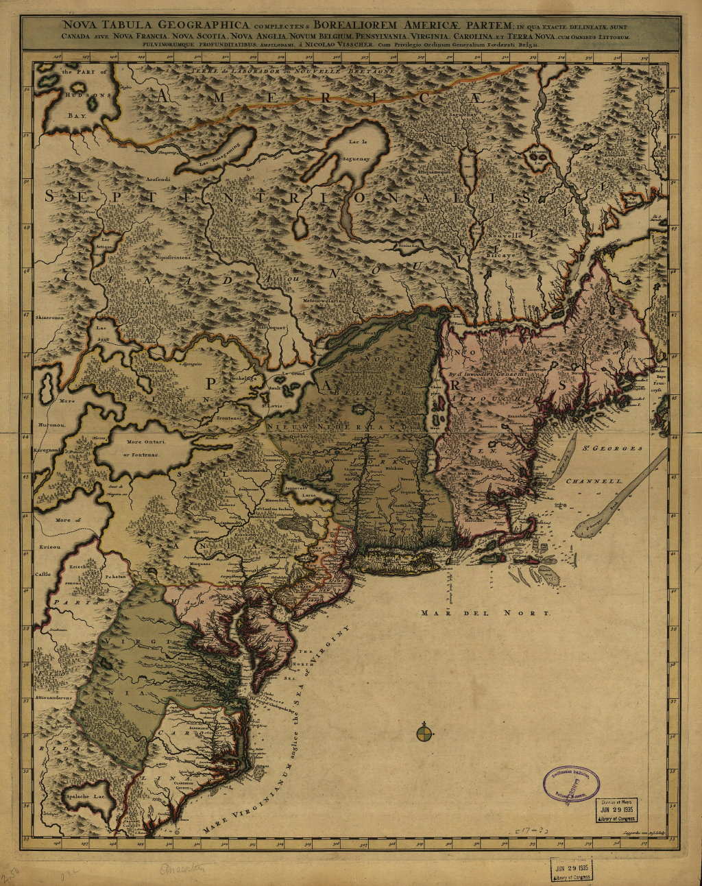
1689.4 NOVA TABULA GEOGRAPHICA COMPLECTENS BOREALIOREM AMERICAE PARTEM; IN QUA EXACTE DELINEATAE SUNT ... PENSYLVANIA, VIRGINIA, ... by Nicolas Visscher (McCorkle #689.8). This is the son of the original Visscher. McCorkle illustrates four states of this map which appears in Dutch atlases into the early 1700's, later versions published by "Petrum Schenk Iunior." It is basically a map of the northeast similar to the Jansson-Visscher maps but with considerably more detail and geographical coverage. It is sometimes matched with an eastern map extending the coverage to Newfoundland. This image is from the Library of Congress, where it can be seen in greater detail , and comes from Atlas Minor sive Geographia Compendiosa, Amsterdam, dated circa 1717 by the LOC. However, the map matches the first state as described in McCorkle. Burden #731 dates the map circa 1696 and says it is difficult to date. |
| 1600-1630 | 1630's | 1640's | 1650's | 1660's | 1670's | 1680's | 1690's |
| Home Page | 16th Century Maps | 17th Century Maps | 18th Century Maps | 19th Century Maps | 20th Century Maps | References |