 |
1920
GULF - AUTOMOBILE BLUE BOOK. This map says copyright 1916
by Automobile Blue Book, however the map is updated from
the 1919 version, and this is believed to be the 1920 map.
|
 |
1921
GULF - AUTOMOBILE BLUE BOOK. This map says copyright 1916
by Automobile Blue Book, however this is believed to be the 1921 map. There are two versions of this map, this one and another with an "Every 1000 Miles..." oil change recommendation on the front cover.
|
 |
1922
GULF - RAND MCNALLY. This is the first Gulf map from Rand
McNally. The map is titled 'BLAZED TRAILS IN
PENNSYLVANIA', and the roads are identified with
trail markings. Trail numbers up to 41 are listed on the
back, though not all are in Pennsylvania or used on the
map. The
Map Image
is similar to previous A.B.B.
maps. |
 |
1923.1
PENNZOIL - RAND MCNALLY. This paper cover, with both
sides shown here, has a 1923 Rand McNally District No. 7
map pasted to the back and folded in. The map is printed
on both sides and includes Pennsylvania, New Jersey,
Delaware, northern Maryland, Virginia, West Virginia, and
southern New York. As the cover shows, Pennzoil was
originally headquartered in Oil City. |
 |
1923.2
SEABOARD & INLAND OIL CORP. - RAND MCNALLY. This
yellow paper cover has a Rand McNally 1923 District No. 7
map folded inside that is printed on both sides. There is
no logo and this company was probably a wholesaler or
distributor rather than a retailer. |
 |
1924.1
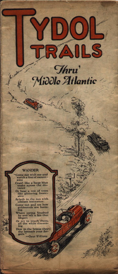
TYDOL - RAND MCNALLY. This map is titled 'Tydol
Trails Thru' Middle Atlantic' and shows Pennsylvania west
to about Chambersburg. It includes New York, New Jersey,
Pennsylvania, Maryland, Delaware, and Virginia. It is
undated but contains a reference to 1924 road
construction. Also, it uses only trail markings and so is
dated 1924. Tydol was a trademark for the Tidewater Oil
Co. which started life as the Tidewater Pipe-Line Company
c1880. It built a pipeline from the northwest
Pennsylvania oil fields to Williamsport where the oil was
transferred by rail to a refinery at Chester,
Pennsylvania, on the Delaware. At the turn of the century
they were about the only competition to the Standard Oil
Trust. |
 |
1924.2
MOBILOIL - RAND MCNALLY. This attractive folder has
a Rand McNally Auto Trails map of Pennsylvania on one
side and New Jersey on the other. "Metro Stations
Inc." was apparently the name Socony used for its
gas retailing in the early years while Mobiloil was used
for the motor oil. |
 |
1924.3
KENDALL - BUFFALO WAX ENGRAVERS, INC. This map is
titled 'General Map of Automobile Routes in New York,
Pennsylvania, and New Jersey', issued by Kendall Refining
Co., published by Frank B. Hoole, Buffalo, N. Y. The gray
paper cover is labeled 'KENCO TOURIST GUIDE'.
This map is undated, though earlier than the dated 1925 map
below. Routes are not named or numbered. On the
inside cover
is a list of about 100
different makes of autos and about 40 different makes of
tractors, names like Hupmobile, Case, Stutz, etc.The guide lists a "M. 1923" car, so the map is dated 1924 here. |
 |
1924.4
PURE - RAND MCNALLY. This cover was used for several years in the mid-20s. The deep blue was the Pure trademark
color.
|
 |
1925.1
PURE - RAND MCNALLY. The Pure Oil Company had some of the
nicer covers through the 30's. This map is subtitled (Philadelphia), which may indicate another map for this year was issued. |
 |
1925.2
KENDALL - FRANK B. HOOLE, BUFFALO, NY. The map is
titled "General Map of Automobile Routes in New York,
Pennsylvania, and New Jersey." Routes are not named
or numbered. The cover is gray paper and on the inside is
a list of about a hundred different makes of autos and
tractors similar to that on the circa 1924 map above. |
 |
1925.3
MOBILOIL - RAND MCNALLY. "Auto Trails of Pennsylvania 1925." A 7.5 x 4 inch paper cover with a 1925 Rand McNally auto trails map of Pennsylvania pasted inside. The cover has a Metro gas and Mobiloil logo. |
 |
1926.1
ATLANTIC - GENERAL DRAFTING CO. After their
1916 map, Atlantic apparently issued no maps until about
1925. This map is undated but is believed to be the 1926
map. Road map cartography took a big step forward with
General Drafting, see the
Map Image
. |
 |
1926.2
KENDALL - RAND MCNALLY. This cover has an attached Rand
McNally Junior Road Map with New York on one side and
Pennsylvania on the other. The map shows both old state
and modern US route numbers. |
 |
1926.3
PURE OIL - RAND MCNALLY. The front cover is the same
as the 1925 map but the back is different. The "Pittsburgh"
marking indicates it has a Pittsburgh city map and there
was also a "Philadelphia" version. |
 |
1926.4
TYDOL - O. M. WELLS, compiled by O. M. Wells,
copyrighted 1926 Conwell Graphic Companies. For some
reason Tydol used this small map printer for the 1926 map.
The map includes New Jersey and Delaware on the verso and
uses old state route numbers. The printer's logo is shown
in the middle of this north central Pennsylvania
Map Image
. |
 |
1926.5
MOBILOIL - RAND MCNALLY. Although both states are named on the cover, this is mainly a large 34 x 28 inch Rand McNally "Auto Trails Map" of New York. On the verso is a smaller "junior" road map of Pennsylvania; and also some small maps of New York cities. It is possible separate road maps were issued for both Pennsylvania and New York in 1926.
|
 |
1927.1
GULF - H. M. GOUSHA, Titled 'Map No. 4 Automobile Roads
in Pennsylvania', this map is coded 'A' which makes it
the first Gousha road map of the state. Apparently Gousha
underbid Rand McNally in 1927 in order to get their
business going. Roads are marked with both 'old' state
and modern US route numbers.The Gousha
Map Image
can be compared to the other
designs. Both Gousha and Rand McNally used a coding
system with the year code printed on the bottom margin of
the map. This code allows dating of many road maps that
are otherwise undated. These codes can be found at the
Road Map Collectors Association
website. Gulf used various
versions of the 'car racing up a hill' motif on its
covers up to 1930. |
 |
1927.2
KENDALL - RAND MCNALLY. This map is undated, but
uses both old state and modern US route numbers. Also,
the graphics indicate a 1927 map. The Bradford refinery
figured prominently on early Kendall maps. In 2007 it
reached a 125th anniversary and is the oldest
continuously operating refinery in the United States; now
under different ownership, of course. |
 |
1927.3
TYDOL - RAND MCNALLY. The map includes New Jersey and
northern Maryland and Delaware with a map of the
northeast on the verso. It is undated but has text with
the 1927 date; also it uses both old state and modern US
route numbers. |
 |
1927.4
ATLANTIC - GENERAL DRAFTING CO. The map includes Delaware.
|
 |
1927.5
MOBILOIL RAND MCNALLY. There is a 1927 Auto Trails map of New York on one side and smaller 'Junior' road maps of Pennsylvania and New England on the other. There is also a very small map of Delaware.
|
 |
1928.1
NATIONAL UNITED - H. M. GOUSHA, titled 'Auto Road Map
Pennsylvania with Directory of National United Service
Stations', copyright 1928 N.U.S. This map has code 'B',
the second Gousha map of Pennsylvania, and is from the
Indiana Tire & Battery Service, Indiana, Pa. N.U.S.
was an association of independent dealers headquartered
in Johnstown, who organized for advertising and bulk
buying purposes. Through the wear and tear, the cover
shows five forms of motorized transportation. |
 |
1928.2
KENDALL - H. M. GOUSHA. The map is coded "B"
for the second Gousha map. Half the map shows
Pennsylvania and the other half shows New York. Here is
the western Pennsylvania
Map Image
. |
 |
1928.3
PURE OIL - RAND MCNALLY. This is a Pittsburgh
version which indicates there was also a Philadelphia
version. |
 |
1928.4
TYDOL - RAND MCNALLY. This map is undated but appears to
be the 1928 map by comparison with the 1927 and 1929 maps.
The verso has a map of the northeast. This copy is rather
dirty. |
 |
1928.5
AMOCO - RAND MCNALLY. The Pennsylvania map covers
only half of the sheet, the verso has a full sheet map of
the northeast. |
 |
1928.6
ATLANTIC - GENERAL DRAFTING CO. This map is undated but
uses modern route numbers and, by comparison, is the 1928
map. |
 |
1928.7
ESSO - GENERAL DRAFTING. As the title says, this map
covers the middle Atlantic states of Pennsylvania,
Delaware, Maryland, Virginia, West Virginia, and the
Carolinas. A 1928 map from Esso specifically for
Pennsylvania has not been seen, although one for New
Jersey was seen. |
 |
1928.8
MOBILOIL - RAND MCNALLY. Besides Pennsylvania, this map
includes New York and New England. Socony apparently used
the name Metro for its gas and Mobil for its oil. |
 |
1929.1
ESSO - GENERAL DRAFTING CO. The map says Standard Oil of
Pennsylvania, the Esso name appears on a sign and gas
pump on the
back cover
. The Esso name appeared around
1928 and this may be the first appearance on a
Pennsylvania map. Esso maps through 1942 are also labeled
Standard Oil of Pennsylvania on the front cover. A 1929
map with this same cover was issued for the Middle
Atlantic States. |
 |
1929.2
KENDALL - H. M. GOUSHA. This map includes New York. |
 |
1929.3
PURE OIL - RAND MCNALLY. This is a very attractive
Art Deco type cover. Both Pittsburgh and Philadelphia
maps are included, so only this one version was published.
|
 |
1929.4
TYDOL - RAND MCNALLY. This map also includes New Jersey,
Maryland, Delaware, and Ohio as part of a relief map on
the verso showing air routes. It is dated from the Rand
McNally date code "K" and it also looks later
than the 1928 map above. |
 |
1929.5
AMOCO - RAND MCNALLY. These early Amoco maps had
attractive and colorful covers. |
 |
1929.6
ATLANTIC - RAND MCNALLY. The map includes New Jersey and
Delaware. |
 |
1929.7
TEXACO - RAND MCNALLY. This same cover was used on both
the 1929 and 1930 maps. |
 |
1929.8
REFINERS - RAND MCNALLY. This map includes only western
Pennsylvania and is a regional map, which is the only
type Refiners apparently issued. It is undated but has
the Rand McNally "K" code for 1929. There is a
map of the northeast on the verso. There is also an
amusing lubrication chart on the
inside
, amusing because most of the
cars and trucks listed are not made anymore. |
 |
1929.9
FREEDOM - MOUNTCASTLE MAP CO. This map is undated
but has modern route numbers and the 1930 map was by Rand
McNally; so, this is believed to be the 1929 map. It
contains two 12 x 19 inch maps of Pennsylvania and Ohio,
plus a map of Pittsburgh and the northeast with the
locations of Freedom stations. Here is the
Map Image
. |
 |
1929.10
STERLING - CLASON. This 4.75 x 3 inch paper cover
has a Clason map pasted inside with the title
CLASON'S ROAD MAP OF PENNSYLVANIA. There are Clason
maps like this (
Map Image
) advertising banks and
insurance companies, etc.; but few that advertise oil
companies. Sterling was later bought out by Quaker Oil. |
 |
1929.11
SUNOCO - RAND MCNALLY. This map has a northeast map
on the verso plus separate maps of Ohio and Michigan. |
 Rand
McNally began making Gulf road maps in 1922 and continued until
1926. In 1927 Gulf turned to H. M. Gousha for its maps. In the
days before television and billboards, free road maps were a
major means of advertising for the oil companies, and in the mid
1920's others joined Gulf in the free map game. The General
Drafting Company and H. M. Gousha also joined Rand McNally in
producing oil company road maps. More than one map for each year
is shown on this page to further illustrate the beginnings of oil
company road maps. Many additional Gulf maps not included here
can be seen in the article The Early Gulf
Road Maps of Pennsylvania
.
Rand
McNally began making Gulf road maps in 1922 and continued until
1926. In 1927 Gulf turned to H. M. Gousha for its maps. In the
days before television and billboards, free road maps were a
major means of advertising for the oil companies, and in the mid
1920's others joined Gulf in the free map game. The General
Drafting Company and H. M. Gousha also joined Rand McNally in
producing oil company road maps. More than one map for each year
is shown on this page to further illustrate the beginnings of oil
company road maps. Many additional Gulf maps not included here
can be seen in the article The Early Gulf
Road Maps of Pennsylvania
. 