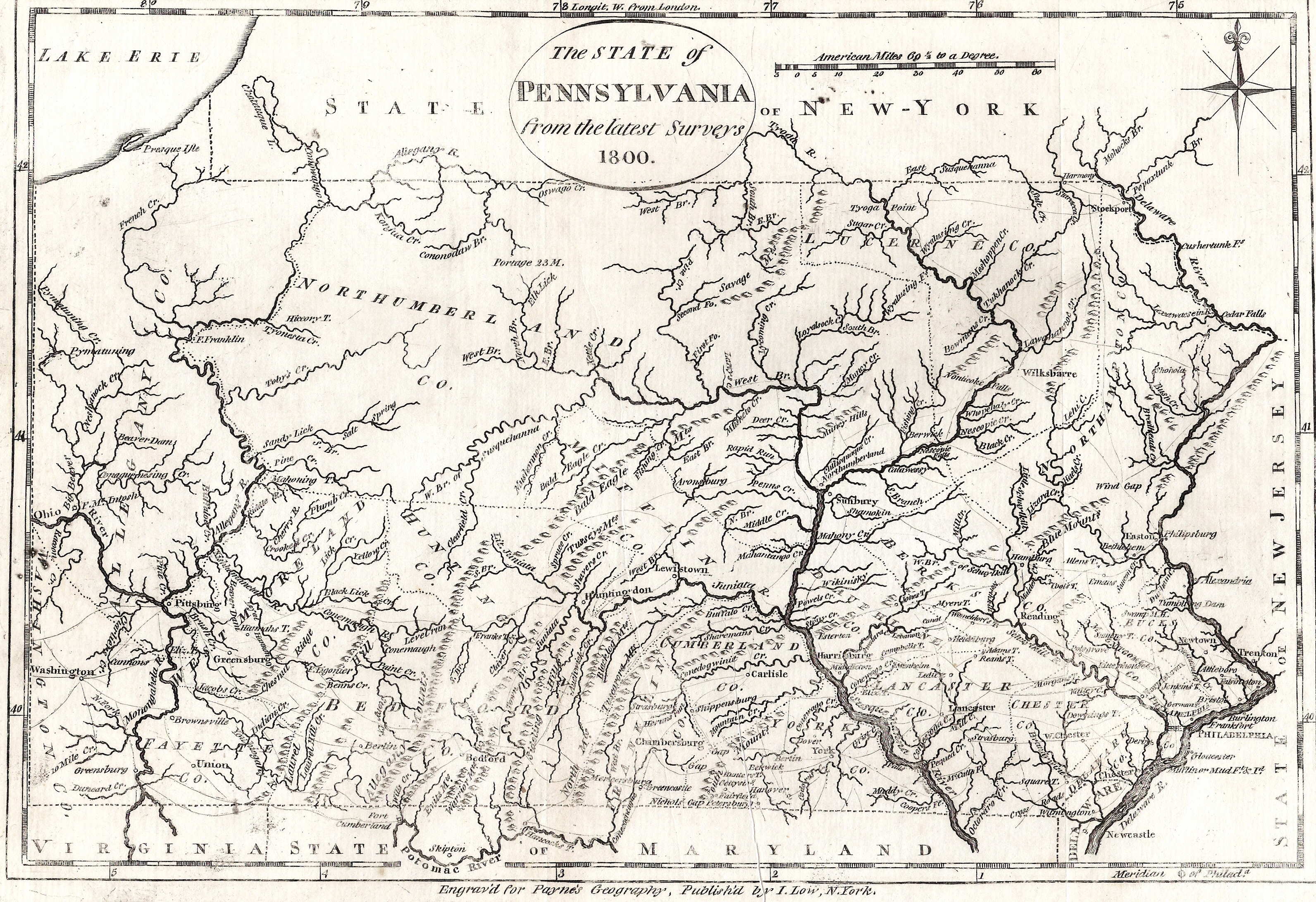
The maps from the first decade of the 19th
century look much like the ones from the 1790's because they came
from the same American publishers. They were originally uncolored,
but some have been colored by later sellers to make them look
more attractive.
Ten new counties were created
in the year 1800, most filling up the northwestern part of the
state: Adams (seat at Gettysburg), Centre (Bellefonte), Armstrong
(Kittanning), Crawford (Meadville), Beaver (Beaver), Butler (Butler),
Erie (Erie), Mercer (Mercer), Venango (Franklin), and Warren (Warren).
Indiana County (seat at Indiana) was formed in 1803, and six
counties in 1804: Cambria (Ebensburg), Clearfield (Clearfield),
Jefferson (Brookville), McKean (Smethport), Potter (Coudersport),
and Tioga (Wellsboro). At the end of the decade there were 42
counties in the state.
 |
1800.1
THE STATE OF PENNSYLVANIA FROM THE LATEST SURVEYS 1800,
Published by J. Low, NYork. This map is from John Payne's
A New and Complete System of Universal Geography,
published c1798-1800 per Lister. It can be dated 1789-95
by counties shown. This same map with the date changed to
1810 appeared in The New and Complete American
Encyclopaedia, published by E. Low, New York. Longitude
from Philadelphia at bottom, west from London at the top.
Blank verso. Scale: 1 inch = 32 miles. Size 8.25 x 11
inches. |
 |
1800.2
IL CANADA, LE COLONIE INGLESI CON LA LUIGLANA E FLORIDA. DI NUOVA PROJEZIONE. Venezia 1800. Presso Antonio Zatta. G. Zuliani inc. This is an 1800 printing of Zatta's 1778 original from Atlante Novissimo Illustrato e Accresciuto Sulle Osservazioni e Scoperte Fatte Dai Pi Celebri e Recenti Geografi. This is the title map showing the east coast, the section of this multi-sheet map showing Pennsylvania is map 1778.7. This map shows the eastern United States and Canada from Nova Scotia to all of Florida and west to beyond the Mississippi. Boundaries are outlined in hand color in this copy and Pennsylvania extends into present day New York with an irregular western boundary ending at the Allegheny Front, a view based on earlier French maps. McCorkle #778.9. Blank verso, with longitude apparently east from Ferro. Scale: 1 inch = 165 miles. Size 12 x 16
inches. |
 |
1800.3
A MAP OF THE UNITED STATES OF AMERICA WITH PART OF THE ADJOINING PROVINCES FROM THE LATEST AUTHORITIES. Engraved on copper by Thomas Conder, from the 2nd edition of Robert Wilkinson s General Atlas, dated 1800-02 per Lister. The map includes the region from New England to Georgia and west to the Mississippi. Florida and the mouth of the Mississippi are cut off. Many Indian tribes are identified; mountains are shown by shaded relief. The map is mounted on linen which, along with the hand coloring, was likely done later. The same map was apparently published in George Alexander Cooke s A Modern and Authentic System of Universal Geography, London 1808; and it was also seen as coming from The History of America... , by William Robertson D.D. London 1817. P. 873 of Phillips dated 1800.
Blank verso, longitude is west from London. Scale: 1 inch = 160 miles. Size 8.5 x 11
inches. |
 |
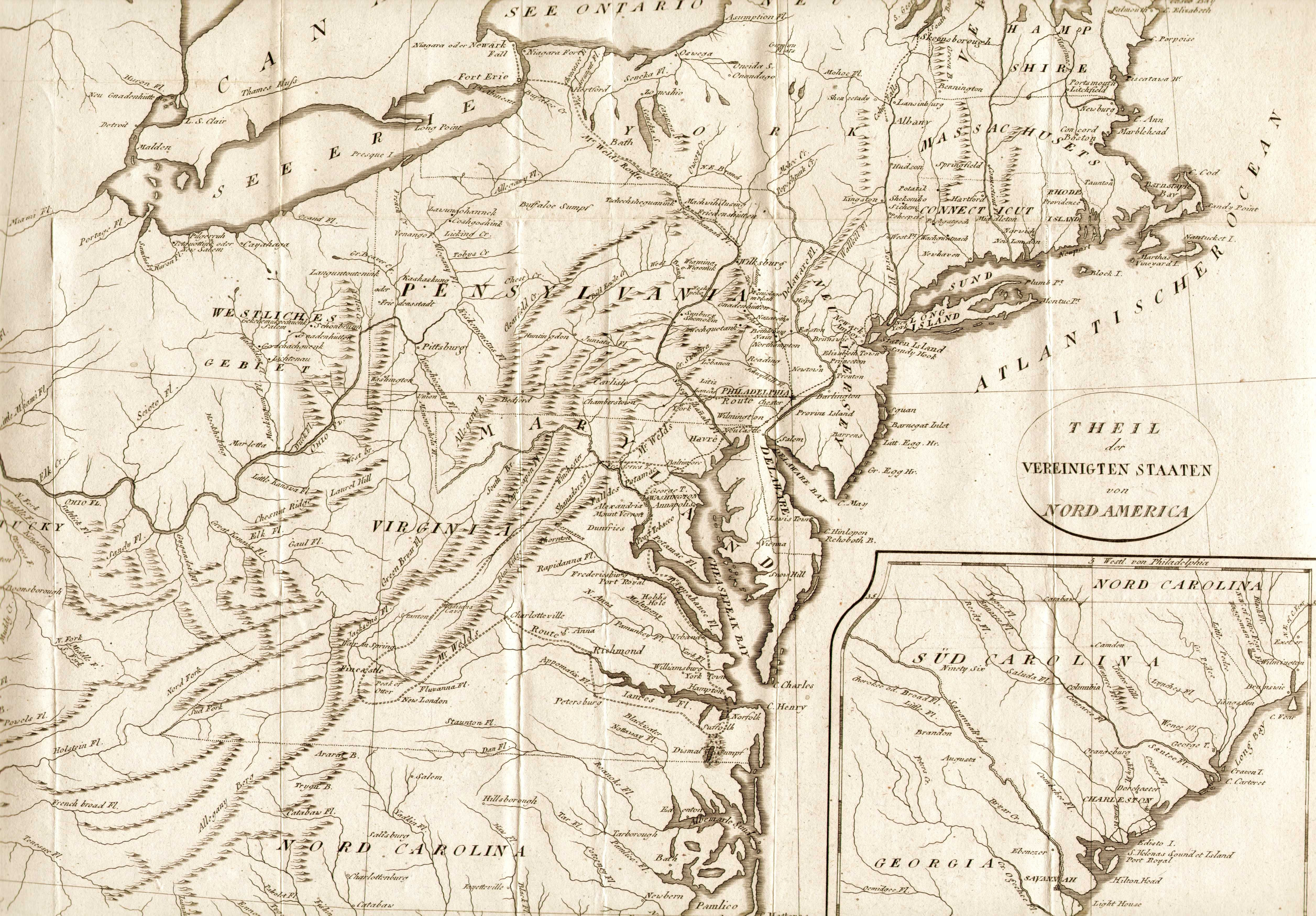
1800.4
THEIL DER VEREINIGTEN STAATEN VON NORD AMERICA, from a German edition of Isaac Weld, Reise Durch die Staaten von NordAmerica, Berlin und Hamburg 1800. This is a German edition of Stockdale's map of 1798 that accompanied the Weld English edition, see map 1798.4. The coverage extends from Maine to South Carolina and westward to include Kentucky, but not to the Mississippi River; and continues on the same scale in an inset of the Carolinas and Georgia, south to the St. Marys River. The map has many place names, includes small villages on the frontier and names Toronto, Detroit, Leestown, Lexington, and Boonsborough. It also locates the Dismal Swamp, and shows trails and roads followd by "Mr. Weld."
Blank verso, longitude from London at top, Philadelphia at bottom. Scale: 1 inch = 35 miles. Size 16 x 18
inches. |
 |
1800.5
UNITED STATES. Published by G. Miller Dunbar. S. Neele & Son, 352 Strand, London. Neele flourished 1798-1820 per Lister. G. Miller Dunbar (also listed as George Miller of Dunbar) lived from 1771 to 1835. He set up a printing shop around 1795 in Dunbar, Scotland and became a general printer and bookseller. This map is undated, but Ohio (1803) is not shown as a state and Tennessee (1796) is, so the map probably dates circa 1796-1803 and is dated 1800 here. Several Miller Dunbar publications were found, but none that would seem to contain maps. Pennsylvania lacks the Erie triangle so the map was copied from older material, and in fact appears to be a direct copy of map 1797.2; so it might date later than 1800. This Miller Dunbar printing has not been seen elsewhere. Blank verso, intaglio print. Scale: 1 inch = 200 miles. Size: 7.25 x 9.25 inches. |
 |
1801.1
PENNSYLVANIA, W. Barker Sculp. This map is from The
American Pocket Atlas, and from the second edition
judging by appearance (see No. 445 in Wheat & Brun),
published by Mathew Carey, Philadelphia 1801. The first
edition of this atlas was published in 1796 (map 1796.2) and other
editions in 1801, 1805, 1813, 1814. The meridian of
Philadelphia is at the bottom and London at the top. Road
networks are shown, however counties are not. The map is
made from two sheets joined at the vertical centerline.
The atlas contained 19 maps: United States, N. W.
Territory, and 17 states. Blank verso. Scale: 1 inch = 15
miles. Size: 8 x 9 inches. |
 |
1801.2
GEDEELTE VAN DEN VEREENIGDEN STAAT VAN NOORD AMERIKA. A map of the eastern part of the United States after the Isaac Weld (1774-1856) map from his Travels through the States of North America... . The coverage extends from Maine to the Carolinas and west through Ohio. In the lower right corner is an inset map of South Carolina. This map is very similar to the previous Weld maps and the track of his travels (and his name) are on the map. McCorkle (#798.5, 799.6, 800.4) mentions English (see map 1798.4), French and German (see map 1800.4 above) editions, but not this Dutch text edition which is believed to come from Reizen door de staaten van Noord-Amerika, en de provinti n van Opper- en Neder-Canada; in de jaaren 1795, 1796 en 1797. Ondernomen door Isa c Weld, junior. Naar den derden druk. Uit het Engelsch vertaald door S. van Hoek.In den Haage, J. C. Leeuwestijn, 1801-02; as listed at the Library of Congress. Blank verso, longitude from Philadelphia at bottom, from London at top. Scale: 1 inch = 52
miles. Size: 16 x 18 inches. |
 |
1801.3
STATES OF AMERICA, DRAWN FROM THE BEST AUTHORITIES, by J. Russell. This map of unknown date and origin is very similar to map 1794.6, but it has a different title, is just slightly larger, and is definitely a different plate. Russell apparently created two maps for two different uses and just changed the title. It has the same title and is also similar to map 1795.8, but is much larger. Kentucky (1792) appears identified as a state, while Tennessee (1796) does not, so the preparation likely dates 1794 or 1795. This map shows the east from Maine to a cutoff Florida and west to the Mississippi like the other maps mentioned. Many towns are named, the river systems shown in some detail, but the mountains only crudely indicated. This copy is closely trimmed to the neat line. A copy seen at auction with the border preserved has at top Engraved for Guthries New System of Geography ; and at bottom London. Published as the Act directs by G. G. & J. Robinson and J. Mawman 1801. So, this map is dated 1801 here. Only the right side of the map is shown. Longitude west from London, blank verso. Scale:1"= 95 miles. Size: 15.75 x 18 inches. |
 |
1801.4
CARTE DE LA PARTIE SEPTENTRIONALE DES ETATS-UNIS. At upper left is "pl. v. a la fin du tom. i." This map is from Voyage Dans la Haute Pennsylvania by Michel Guillaume de Crevecoeur. Coverage extends from the northern reaches of Chesapeake Bay to Maine and eastward to show most of Lake Erie. All of Pennsylvania is included. There are a number of place names and details including the road system in the nascent nation; and also information on Indian tribes and villages. Crevecoeur was a French immigrant to the United States who gain fame describing the emerging American national character in his Letters of an American Farmer, first published in 1782 with a 1787 French edition (see map 1787.1). This map was included in Volume I of Crevecoeur's work and was engraved in Paris by P. F. Tardieu. Blank verso, longitude from Washington. Scale: 1 inch = 40
miles. Size: 14 x 20 inches. |
 |
1801.5
THE UNITED STATES OF AMERICA. London: Published by Laurie & Whittle Fleet Street. Octb. 1st. 1801. Jones & Smith sculp. Pentonville. This map appeared in Robert Laurie and James Whittle's New and Elegant General Atlas published in 1804, 1806. It is a map of the eastern United States to beyond the Mississippi, with northern Maine and southern Florida cut off. Towns and many rivers named. Longitude west from London, blank verso. Scale:1 inch =187 miles. Size: 7.75 x 9.25 inches. |
 |
1801.6
A MAP OF THE UNITED STATES OF AMERICA. Published by Thomas & Andrews Boston 1801. Engraved for Morse's Elements of Geography. This map was found in Elements of Geography, containing a concise and comprehensive view of that useful science, ..., by Jedidiah Morse, D.D. Fifth edition improved. Boston: Printed for Thomas & Andrews, No. 45 Newbury-Street...July, 1804. Based on its date, it was originally prepared for an earlier edition. This is a simple map, emphasizing the rivers. |
 |
1802.1
UNITED STATES OF NORTH AMERICA, from
Arrowsmith's large map. Arrowsmith direxit.
Lowry sculp. Published March 1st, 1802 by Cadell and
Davies, Strand, and Longman and Rees, Paternoster Row.
This map is from an Arrowsmith atlas and is marked at top
right 'vol.iii page 39'. It shows the east
coast with Florida cut off. Rivers are outlined in blue
and mountains in brown, several towns in Pennsylvania are
identified. The term 'large map' refers to
Arrowsmith's map of 1796 (see map 1796.5),
published again in 1802, which was 48 x 56 inches. This
atlas map is 8 x 10 inches. Longitude west from Greenwich,
blank verso. Scale: 1 inch = 178 miles. |
 |
1802.2
AN ACCURATE MAP OF THE UNITED STATES OF NORTH AMERICA. This map is believed to be from A System of Geography : or a descriptive historical and philosophical view of the several quarters of the World by Samuel John Neele. Glasgow: Niven, Napier, and Khull, 1802. Neele sc. 352 Strand is printed in the lower right margin. Originally folded, this map shows the pre-1800 political boundaries of the United States including Kentucky and the Tennessee government with carved-out areas identified as Land reserved for Virginia troops and Land reserved for N. Carolina troops. The northwest territory is marked Divided into 10 states by a Resolve of Congress in 1784. Land earmarked for the Illinois company and the N. Jersey company are identified along the Mississippi River just east of present day St. Louis. Land earmarked for the Wabash company is located at the junction of the Wabash and Ohio rivers. Southern Florida and northern Maine are cut off. The locations of many Indian tribes (Chipawas, Illinois, Miamis, Nadowessis, Outigamis, Utawas, etc.) are shown. Pennsylvania is shown without the Erie triangle, so the map is based on old information. Intaglio print. Blank verso, longitude west from London. Scale: 1 inch = 206 miles. Size: 7.25 x 9 inches. |
 |
1802.3
CHARTE DER OSLICHEN VEREINIGTEN STAATEN VON NORD AMERICA. Gestochen von J.N. Champion I.G. (Plate) XX at top right. This German map dates to circa 1802. Lister has a reference to Johann Georg August Galletti, who published Allgemeine Weltkunde... , Leipzig 1807-10; and whose maps were made by Champion. Tennessee is indicated as a state (1796), but not Ohio (1803); so, an early 1800 date seems indicated. Rudimentary state boundaries shown with later hand color. Intaglio print, blank verso, originally folded at left edge. Longitude from Paris at bottom, from Ferro at top. Scale: 1 inch = 222 miles. Size: 8 x 10 inches. |
 |
1803.1
CARTE DES ETATS-UNIS DE L'AMERIQUE NORD Pour servir
au Tableau du Climat et du Sol. Grave par E. Collin. Par
C. F. Volney from Tableau du Climat et du Sol des
Etats-Unis d'Am rique suivi d' claircissemens sur
la Floride, sur la colonie Fran aise au Scioto, sur
quelques colonies Canadiennes et sur les Sauvages, Paris,
Courcier et Dentu, 1803. The book contains two folding
engravings and 2 folding engraved maps, one of the first
books to treat North American climate, soils, geology and
diseases. This map shows the eastern United States. An
engraving shows the soil composition at various depths in
Kentucky, and is sometimes called the first geological
map of North America. An English edition was published in
1804 titled View of the Climate and Soils of the
United States of America. Volney was one of those
European travelers to America, numerous at the turn of
the 19th century, who wrote of their journey; though he
was more scientific than most. See map 1804.6 below. Size: 17 x 21.5 inches. |
 |
1803.2
DIE VEREINIGTEN STAATEN VON NORD-AMERIKA. Zu Finden bey Joh. Walch in Augsburg. This map is from the 1803 Allgemeine Atlas by Johannes Walch. It shows the eastern United States and Canada from Nova Scotia to a cutoff Florida and west to the Mississippi. Kentucky is shown but not Tennessee or Ohio which would place its information origin in the late 1790s. Germantown and Philadelphia are named in Pennsylvania and town names are sparse. There were later editions of the atlas with this exact same map. Blank verso, longitude east from (probably) Ferro. Scale: 1 inch = 220 miles. Size: 7.25 x 8.75 inches. |
 |
1803.3
UNITED STATES. This anonymous and undated small map probably dates between 1803 (Ohio shown as a state) and 1812 (but not Louisiana). Longitude is shown from Philadelphia at bottom (and from London at top), so it probably comes from a Philadelphia publisher like Matthew Carey. The map shows the region from Maine to a cutoff Florida and west to beyond the Mississippi and appears to have been folded into a book. Blank verso. Scale: 1 inch ~ 250 miles. Size: 6.5 x 7.5 inches. . |
 |
1804.1 PENNSYLVANIA,
Drawn by S. Lewis, Eng'd by D. Fairman, from Arrowsmith
& Lewis' New and Elegant General Atlas, 1st
ed. Philadelphia, John Conrad & Co.; editions were
published in 1804, 1805, 1812, and 1819 per Lister.
Although published in 1804, the map is dated 1800-1803 by
counties shown and the same identical map was published
in all later editions of the atlas. The maps were
originally uncolored but colored versions have been seen.
See page 680 of Phillips. Blank verso. Scale: 1 inch = 34
miles. Size: 9 x 10.5 inches. |
 |
1804.2 MAP OF THE NORTHERN PARTS OF THE UNITED STATES OF AMERICA, by Abraham Bradley Jr. corrected by the author; from the American Gazetteer... by Jedidiah Morse, Charlestown; Second Edition, Thomas and Andrews Boston 1804. This map says "corrected by the author" but it is very much the same as the map in the first edition of Morse's book, see map 1797.3. It shows Maine to Virginia and west to Illinois. Ohio is labeled 1st state, Indiana is II state, Illinois III state, Michigan IV state, Wisconsin V state. Western New York is the "land of six Indian nations", northeast Ohio is New Connecticut county. Pennsylvania has its correct boundaries. This same map also appeared in Morse's American universal geography published in 1802. Listed in Phillips p. 874, which also lists a companion Map of the Southern Parts ' . Blank verso, longitude from Washington. Scale: 1 inch = 100 miles. Size: 9 x 16 inches. |
 |
1804.3 UNITED STATES, Drawn by S. Lewis, Tanner, Sc. This map is from A New and Elegant General Atlas, by Arrowsmith & Lewis 1st ed., Philadelphia, John Conrad & Co., 1804. Other editions published by Thomas & Andrews, Boston, appeared in 1805, 1812, and 1819 per Lister, and the very same map appeared in all editions. It shows the eastern United States from Maine to a cutoff Florida and west to the Mississippi. Ohio is shown as a state (1803). Blank verso, longitude from Philadelphia at bottom, from London at top. Scale: 1 inch = 180 miles. Size: 7 x 9.75 inches. |
 |
1804.4 ETATS UNIS DE L'AMERIQUE. Plate XXXII from the atlas to accompany G ographie moderne, Paris, Dentu 1804; which was a French edition of Modern Geography by John Pinkerton. The full and impressive title is: G ographie moderne : r dig e sur un nouveau plan, ou Description historique, politique, civile et naturelle des empires, royaumes, tats et leurs colonies... renfermant la concordance des principaux points de la g ographie ancienne et du moyen ge avec la g ographie moderne par J. Pinkerton; ouvrage destin pour les biblioth ques et l'usage des lyc es ; traduite de l'anglais, avec des notes et augmentations consid rables, par C. A. Walckenaer, pr c d e d'une Introduction la g ographie math matique et critique, par S. F. Lacroix..., accompagn e d'un atlas in-4o de 42 cartes dress es par Arrowsmith..., revues et corrig es par J. N. Buache.Paris : Dentu 1804. The map certainly does resemble the Arrowsmith map above. Blank verso, longitude from Paris. Scale: 1 inch = 180 miles. Size: 7 x 9.75 inches. |
 |
1804.5 PARTE DEGLI STATI UNITI DELL' AMERICA SETTENTRIONALE DEL VIAGGIO DI WELD. An anonymous and undated Italian map based on the Isaac Weld map per the note under the title. This probably refers to the John Stockdale map 1798.4, and Ohio (1803) is not named, so the map probably dates 1798-1804. It is dated circa 1804 here. It resembles the Weld Dutch map 1801.2 in showing Pennsylvania without the Erie triangle. Rhode island is not named and there are other differences, including size, from the other Weld maps. Intaglio print, blank verso, longitude from Philadelphia. Scale: 1 inch = 115 miles. Size: 8 x 8.75 inches. |
 |
1804.6 UNITED STATES. This map is from A View of the Soil and Climate of the United States of America..., by C.F. Volney, translated with occasional remarks by C.B. Brown. Philadelphia: J. Conrad & Co.... 1804. It is the English editon of Tableau du Climat et du Sol des Etats-Unis d'Am rique (see map 1803.1), one of the first books to treat the soil, climate, etc. of the country. This foldout map shows the country west to the Mississippi. This English edition also has a map of North America, an illustration of Niagara Falls, a map of the Niagara River, as well as a geological layer illustration. Intaglio print, blank verso, longitude west from London at top, from Philadelphia at bottom. Scale: 1 inch ~ 200 miles. Size: 10 x 10 inches. |
 |
1805.1
A MAP OF THE ALLEGHANY, MONONGAHELA AND YOHIOGANY RIVERS,
engraved for Harris' journal by Thomas Wightman. This map
is from Journal of a Tour in the Territory Northwest
of the Allegheny Mountains Made in the Spring of the Year
1803 by Thaddeus Mason Harris, published in 1805.
Many travellers in the early part of the century
published their diaries and itineraries with maps. A list
of such journals is given by Vail. Listed in Phillips
pages 99, 680. Blank verso. Scale: 1 inch = 15 miles.
Size: 14.5 x 10.5 inches. |
 |
1805.2
KAART VAN DE NOORDLIJKE PROVINCIEN DER VEREENIGDE STAATEN. D. Veelwaard, Jr., A. Loosjes Pz. This map is from Het Leven van George Washington by John Marshall, te Haarlem, A. Loosjes, 1805 per Phillips p. 875. It dates from 1789-95 by counties shown. There is a companion zuidlijke (southern) map also. This Dutch edition of Marshall s Life of George Washington predates the American and French editions of 1807, see below. The map is much the same size and scale, but Dutch names are used. Blank verso, longitude from Washington. Scale: 1 inch = 46 miles.
Size: 12.5 x 19.25 inches. |
 |
1805.3
UNITED STATES. Engraved by E. Jones, drawn under the direction of Mr. Arrowsmith &c. Published as the Act directs Sept. 1.1805. by Longman, Hurst, Rees & Orme Paternoster Row. This is a finely detailed and engraved map credited in the inscription to Aaron Arrowsmith and printed on good quality, high-rag content paper typical of the period. It is a double page map from an atlas folded at the center line where there is light browning. The United States is shown from Maine to Georgia (Florida is cut off) and west to the Mississippi. Kentucky and Tenessee are named; several towns in Pennsylvania are named but not counties; mountains are shown with fine engraving. The source of this map is not known, but it may be from an edition of The Ancient and Modern Atlas published by Abraham Rees. A map similar to this, although larger (16.5 by 19.75 inches), was apparently published in The Cyclopaedia: a universal dictionary of arts, sciences, and literature, edited by Abraham Rees London: Longman, Hurst, Rees, Orme & Browne, in 1809, and also in 1820. The map from the 1805 edition of Arrowsmith & Lewis' New and Elegant General Atlas (see map 1804.3 above) is similar but not the same. Blank verso, longitude from Greenwich. Scale: 1 inch = 132 miles.
Size: 10 x 12 inches. |
 |
1805.4
A MAP OF THE UNITED STATES AND PART OF LOUISIANA. Eng. by Wm. Kneass. This map is from A Geographical Dictionary of the United States of North America. Containing a General Description of Each State; and of Each the Population, Number of Acres, Soil, Productions, Natural Curiosities, Various Climates, &c. Also a Description of the Rivers, Lakes, Mineral Springs, Mountains, Manufactures, Trade and Commerce. With a Succinct Account of Indiana, Michigan, and Upper and Lower Louisiana Territories. Likewise the Population of Each County, Township, and those Towns in the Union, the Population of which Has Been Ascertained by the Census of Eighteen Hundred. To which is Added, a Description of More than One Thousand Places, Not Noticed in Any Former Geographical Work. Embellished with a Handsome Map of the United States. by Joseph Scott, Philadelphia: Printed by Archibald Bartram, for Jacob Johnson, and Co. 147, Market Street. 1805. It is a dictionary of place names with description; and this map is also shown in the article Pennsylvania in Old Geography Books. Pennsylvania is described on several pages with a table of county information. The map shows the country to well beyond the Mississippi with the west blank except for rivers. In the east, state boundaries are shown with dots and a few towns are named. Blank verso, the meridian of Philadelphia is used at top, London at bottom. Scale: 1 inch ~ 200 miles. Size: 8.5 x 10.5 inches. |
 |
1805.5
UNITED STATES. Neele Sc. 352 Strand. Except for missing text along the bottom and the added cartouche with title at lower right, this map is identical to map 1797.2. The exact dating and source of this version is not known, but it may come from an 1805 edition of Guthrie's geography. The map shows the country from Maine to northern Florida and west to the Mississippi. Pennsylvania does not have the Erie triangle indicating the source material dates prior to 1792. Longitude west from Greenwich, blank verso. Scale: 1 inch = 240 miles. Size: 7.25 x 9.5 inches. |
 |
1806.1
LES ETATS UNIS DE L'AMERIQUE, dessine par Herisson, Glot
sculp. Page 48 from a French atlas, probably published by
Boiste, Paris c1806-1815. Lister lists an atlas dated
1806 for Pierre Claude Boiste, who died in 1824, and this
map may be from that atlas or a slightly later one. This
map extends west to the upper reaches of the Missouri.
Pennsylvania has an enormous Erie triangle and an
irregular southern boundary. Georgia extends to the
Mississippi, Ohio includes most of Indiana. Illinois is
named, also named are numerous Indian tribes. The map
postdates creation of Ohio as a state (1803) but its
boundaries are not shown correctly. It predates creation
of the states of Indiana (1816), Illinois (1818),
Mississippi (1817) and Alabama (1819). State boundaries
are shown with a thin dotted line colored over. Numerous
Indian tribes are named and six different milage scales
are shown at lower right. Blank verso. Scale: 1 inch =
250 miles. Size: 7 x 9 inches. |
 |
1806.2
A NEW MAP OF THE UNITED STATES OF AMERICA, from the latest authorities by John Cary, Engraver. 1806. London: Published by J. Cary, Engraver & Mapseller No. 181 Strand Feby. 1st. 1806. This map shows the eastern United States and southern Canada from Nova Scotia to central Florida and west to beyond the Mississippi. Pennsylvania is shown with modern boundaries; rivers are shown and several towns named. There are several descriptive notes on rivers, Indian tribes, etc. This copy has some surface damage. Blank verso, longitude west from Greenwich. Scale: 1 inch = 140 miles. Size: 18 x 20 inches.
|
 |
1806.3
A NEW MAP OF PART OF THE UNITED STATES OF NORTH AMERICA, containing those of New York, Vermont, New Hampshire, Massachusets, Connecticut, Rhode Island, Pennsylvania, New Jersey, Delaware, Maryland, and Virginia. from the latest authorities by John Cary, Engraver. 1806. London: Published by J. Cary, Engraver & Mapseller No. 181 Strand Sept. 1st. 1806. This map is similar to the one above but shows only the northeast. There is a companion map of the midwest similarly titled which also includes Pennsylvania. Blank verso, longitude west from Greenwich. Scale: 1 inch = 45 miles. Size: 18 x 20.5 inches.
|
 |
1806.4
CARTE GENERALE DES ETATS-UNIS Par E. Mentelle, Membre De L'Institut National... et P.G. Chanlaire, l'un des auteurs de L'Atlas National. 1806. Grave par P.F. Tardieu, Place de L'Estrapade No.2. Longitude occidentale du meridien de L'Isle de Fer. No. 156 printed at upper left and there is a stamped '168' on the verso. The eastern United States (and southern Canada) is shown from Newfoundland to Florida and west to the Mississippi. Ohio is not shown as a state, so the map is slightly out of date. Florida is divided into east and west. This map was originally folded down the middle, and from Atlas Universel de Geographie Physique et Politique. It is an intaglio print with hand outline color, verso blank except for stamp. Longitude west from Ferro. Scale: 1 inch = 140 miles. Size: 15 x 18.5 inches.
|
 |
1807.1
A MAP OF THE COUNTRY FROM RARITON RIVER IN EAST JERSEY TO
ELK HEAD IN MARYLAND SHEWING THE SEVERAL OPERATIONS OF
THE AMERICAN AND BRITISH ARMS IN 1776 & 1777,
engraved for Washingon's Life, drawn by S. Lewis from
surveys made by orders of G. Washington, engraved by I. H.
Seymour, published by C. F. Wayne, Philadelphia. This map
is Plate V from the atlas to the American edition of The Life of
George Washington by John Marshall published in 1807
(LeGear L247). Fite & Freeman reproduce Plates II, IV,
VII, and VIII with discussion.The map includes portions
of New Jersey, Delaware, and the Philadelphia region west
to Westchester and north to Doylestown. The scale is so
large no longitude is shown. The other plates are as
follows: I. Boston with it's Environs; II. Plan of New
York Island and part of Long Island; III. Plan of the
Country from Frogs Point to Croton River; IV. Plan of the
Northern Part of New Jersey; V. This map; VI. Map of the
Country which was the scene of the Operations of the
Northern Army; VII. Map of part of Rhode Island Showing
the Positions of the American & British Armies at the
Siege of Newport; VIII. Map of part of Virginia, North
Carolina, South Carolina & Georgia; IX. Plan of the
Investment and Attack of York in Virginia; X. Plan of the
Siege of Charleston in S. Carolina. Blank verso. Scale: 1
inch = 8 miles. Size: 10.5 x 17 inches. |
 |
1807.2
CARTE DES PROVINCES SEPT.LES DES ETATS-UNIS. Plate II from the French edition of Vie de George Washington by John Marshall, published in 1807 by Dentu, Paris (Lister, L248 in Legear). The map dates from 1789-95 by counties shown. This map is #784.4 in McCorkle, who does not know the source and gives a 1784 date as conjectural. The maps in the American edition published by C. P. Wayne, Philadelphia, in 1807 were by Samuel Lewis (see the map above); several of these are reproduced in Fite & Freeman and are ~10 x 16 inches. This map and a similar one for the southern states are larger and unique to the French and Dutch editions (see map 1805.2). This is confirmed in Legear where the American edition (L247) is listed as having ten maps and the French edition (L248) twelve. An Atlas to Marshall s Life of Washington was published by Crissy in 1832, 1850 with smaller scale maps (Lister). They were ~11 x 9 inches and bound along the vertical centerline. This larger map was originally folded and bound at the edge. Major roads are shown, mountains, swamps, and shorelines engraved in shaded relief; dates 1789-95 by counties shown and is similar to the Dutch map above. The same plate (without the plate mark II) was reported used in the French edition of Carlo Botta s Storia della Guerra dell' Independenza Degli Stati Uniti d'America published in 1812-13 in Paris. Blank verso, longitude from Paris at top, Ferro at bottom . Scale: 1
inch = 38 miles. Size: 12.5 x 19.5 inches. |
 |
1807.3
A MAP OF THE UNITED STATES OF AMERICA WITH PART OF THE ADJOINING PROVINCES FROM THE LATEST AUTHORITIES, from A Modern and Authentic System of Universal Geography ... by George Alexander Cooke. London : for C. Cooke, ca 1807. A date of 1808 has also been seen for this map, apparently drawn by Aaron Arrowsmith and engraved by J. Lodge. It shows the eastern United States and southern Canada from Nova Scotia to a cutoff Florida and west to the Mississippi. Rivers and several towns in Pennsylvania are named. This map is almost identical to map 1800.3 above except for coloring and this general purpose Arrowsmith map was apparently used freely in British publications of the period. A similar map was published in the 1799 edition of the Rev. Clement Crutwell's New Universal Gazetteer of Geographical Dictionary (map 1799.8). Blank verso, longitude west from Greenwich. Scale: 1
inch = 160 miles. Size: 8.5 x 10.75 inches. |
 |
1807.4
PLAN OF THE CITY OF PHILADELPHIA PA, Pub. Mar 1, 1807, by James Cundee, London. This map is believed to be from The Stranger in America by Charles William Janson, Esq. .London: Albion Press, 1807. The full and impressive title reads: The Stranger in America: containing observations made during a long residence in that country, on the genius, manners and customs of the people of the United States; with biographical particulars of public characters; hints and facts relative to the arts, sciences, commerce, agriculture, manufactures, emigration, and the slave trade. The map shows the downtown portion of the city and the two rivers that border it. At the top is an illustration of two female characters, one holding a cornucopia and one holding what appears to be a map. The major streets of the city are labeled. The coloring on this copy is probably a later addition. The scale is measured in 100 perches to an inch. Blank verso, no longitude. Size: 8 x 10 inches. |
 |
1807.5
MAP OF THE RIVER ST LAWRENCE FROM ITS EMBOUCHURE TO ITS SOURCE TO ILLUSTRATE A PICTURESQUE DESCRIPTION OF THE CANADAS. London, Published March 1st, 1807, by R. Phillips, New Bridge Street. Neele Sc. Strand. A map of southern Canada and the northeast, printed on thick paper. The map names Upper Canada, Lower Canada, New Brunswick, Nova Scotia, New England, Pennsylvania and New York. Only the northern two-thirds of Pennsylvania is shown and nothing is named. This map is likely from Travels through the Canadas : containing a description of the picturesque scenery on some of the rivers and lakes : with an account of the productions, commerce, and inhabitants of these provinces : to which is subjoined a comparative view of the manners and customs of several of the Indian nations of North and South America, by George Heriot, Esq. London : Printed for Richard Phillips ... by T. Gillet ..., 1807. Blank verso, longitude west from London. Scale: 1 inch = 102 miles. Size: 9.5 x 15 inches. |
 |
1808.1
THE UNITED STATES OF AMERICA ACCORDING TO THE TREATY OF PEACE OF 1784. This map is Plate xxv from a later edition of William Guthrie s New geographical, historical grammer originally published in 1795. It is identical to map 1795.9 from Guthrie but is Plate xxv (at top) instead of Plate xxiii. The original map was prepared by John Russell and the Treaty of 1783, which ended the Revolutionary War, is misdated. The map shows the eastern United States west to the Mississippi, and still Spanish Florida is cut off as was usually the case with maps of this period. A list of 15 states is on the left. Pennsylvania lacks the Eire triangle so the original preparation was in the early 1790s; several town names are included. The color on this copy is not original. Blank verso, longitude west from London. Scale: 1 inch = 200 miles. Size: 7.25 x 7.75 inches. |
 |
1808.2
UNITED STATES; OR FREDON. Engrd. for Spafford's Geography. 1808. H.G. Spafford del. G. Fairman sc. This map comes from General Geography, and Rudiments of Useful Knowledge: in nine sections, by H.G. Spafford, Hudson: Printed by Croswell & Frary 1809. It shows the United States from Maine to a cutoff Florida and west to the Mississippi. Ohio and Indiana are named, but no boundaries shown; and Pennsylvania does not include the Erie triangle. A child (probably) has colored parts of this black & white map with pencil. There can't be many maps with this title. "Fredon" is probably derived from freedom and might be original with Spafford as no other use like this has been seen; though there are some "Fredon" place names in the United States. Blank verso, longitude west from London at top, from Philadelphia at bottom. Scale: 1 inch = 185 miles. Size: 7.75 x 9.75 inches. |
 |
1809.1
UNITED STATES, a map thought to be by Aaron Arrowsmith
and dated circa 1809. However, Ohio is not identified so
the basis of the map precedes 1803. The map shows the
United States west to the Mississippi with Florida cut
off and appearing in an inset. The hand coloring does not
separate Pennsylvania and New Jersey. Several towns are
shown including 'Ft. Franklin formerly Venaga.' This map
is similar to the 1802 map shown above. Longitude west
from Greenwich, blank verso. Scale: 1 inch = 165 miles.
Size: 8 x 9.75 inches. |
 |
1809.2
UNITED STATES IN NORTH AMERICA. Published, March 1, 1809, by R. Phillips, Bridge Street, Blackfriars, London. This originally folded map from an unknown source shows the east coast from Maine to a cutoff Florida and west to the Mississippi. Pennsylvania is shown without the Erie triangle and there is no Ohio (1803), so it reflects old information and is probably a copy of an earlier map. Some roads are shown including the Forbes road across Pennsylvania and many towns are named. Only the right half is shown in this view including all of Pennsylvania. Blank verso, longitude west from London. Scale: 1 inch = 110 miles. Size: 15.5 x 13 inches. |
 |
1809.3 CARTA
DELLE PROVINCIE SETTENTRION DEGLI STATI UNITI. This is an
Italian map of the northeast of uncertain date and origin.
It resembles McCorkle #799.2, the French edition of Rochefoucauld-Liancourt's Travels, however there is no known Italian edition. This map is likely from some edition of Carlo Botta's history of the United States, Storia Della Guerra dell' Independenza degli Stati Uniti D'Ameria with a first edition in 1809 and later printings and translations, so an 1809 date is used here. An edition in English was titled History of the
War of the Independence of the United States of America published
in Boston in 1826. The map
covers the northeast from southern Maine to Maryland and
west to include all of Pennsylvania. Most of the map is
shown in this image. Italian names are used for some of
the towns and harbors e.g. Capo Cod (Cape Cod) and Golfo
Buzzard (Buzzards Bay). A companion map seen shows the region from the Chesapeake to Georgia and is titled CARTA DELLE PROVINCIE MERIDIONALI DEGLI STATI UNITI. Longitude west from Ferro, blank
verso. Scale: 1 inch = 40 miles. Size: 12.5 x 19 inches. |