The 1830's saw the appearance
of traveler's pocket maps, which were atlas maps printed on
vellum type paper and folded into a small leather case. Many of
the earlier ones were published by S. Augustus Mitchell. The
Allegheny Portage Railroad, part of the Pennsylvania Canal and
now a National Historic Site, was completed in this decade. The
Portage had 10 inclined planes with interconnecting rail lines
and carried goods and canal boats over the Allegheny Front from
Hollidaysburg to Johnstown. The canal was never a financial
success and was bought out by the Pennsylvania Railroad in 1857.
Three counties were created
in this decade: Juniata (seat at Mifflintown) in 1831, Monroe (Stroudsburg)
in 1836, and Clinton (Lock Haven) in 1839.
 |
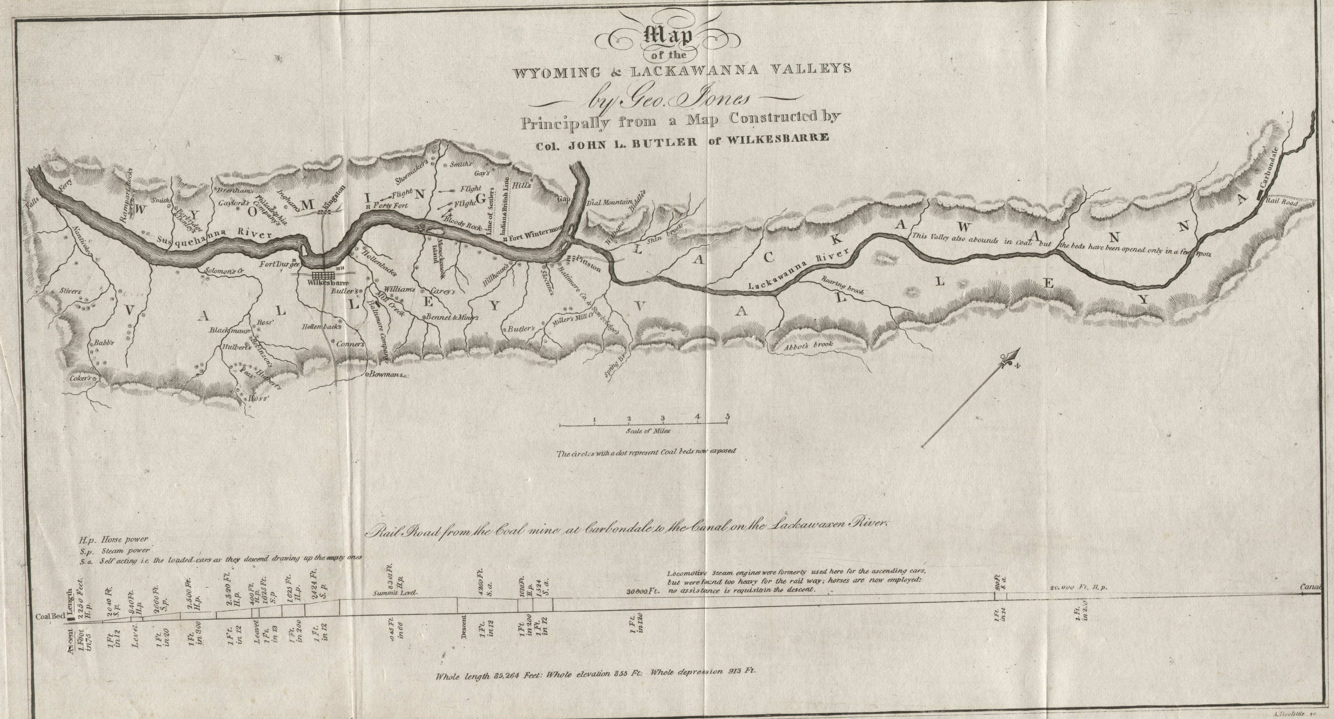
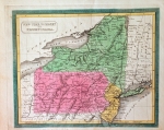
1830.1
MAP OF THE WYOMING & LACKAWANNA VALLEYS by Geo. Jones,
principally from a map constructed by Col. John L. Butler
of Wilkesbarre. A. Dolittle Sc. This map of uncertain
date shows the Susquehanna River area of Wilkes-Barre and
Pittston and the Lackawanna River valley up to Carbondale;
there was no Scranton. There is an elevation map at the
bottom with title, and the mountains are shown by fine
hachures. Dolittle died in 1832 so the plate was engraved
before then. The Lackawanna Canal was probably built in
the late 1820's, so this map likely dates circa 1828-32.
Coal was a major interest in these parts in the 19th
century and is the theme of this map; a slew of little
markers designate exposed coal beds. There is also
the "Indian & British Line" and the "Line
of Settlers." Blank verso. Scale: 1 inch = 2.5 miles.
Size: 8 x 14.5 inches. |
 |
1830.2
PENNSYLVANIA, from An Epitome of Universal Geography , by Nathan Hale, published by N. Hale; Richardson, Lord & Holbrook; Crocker & Brewster, and Gray & Bowen. Boston 1830. This book contained sixty maps including maps of other states. Some county seats are identified, mountains crudely shown. The map identifies the Philadelphia-Columbia railroad and parts of the mainline canal. The verso is page 68 with text, indicating this map is likely printed by stereotype from a wood engraving. Longitude west of London. Scale:1 inch = 50 miles. Size: 3.75 x 6 inches. |
 |
1830.3
PLAN OF THE BATTLE BRADDOCK S DEFEAT, AT THE BEGINNING OF THE ACTION, JULY 9TH 1755. The form of the ground drawn on the spot by J. C. Gilleland. 1830. The source of this small map is not known, but was probably a history book of somewhat later publication date, possibly by Jared Sparks, a noted author of the time. It shows Braddock s army deploying along a road surrounded by the French and Indians. The engraver was G.W Boynton & Co. sc. At the top is Vol. ii.p.90.' Intaglio print, blank verso. The scale is in 100 perches to a foot. A perch is about 5.5 yards. The width of the battlefield along a ridge is about 20 perches, or 110 yards. Size: 8.5 x 5 inches. |
 |
1830.4
THE MIDDLE STATES MARYLAND & VIRGINIA, J.H. Young sc. This map is from A New General Atlas Exhibiting the Five Great Divisions of the globe, Europe, Asia, Africa, America and Oceanica, with their several Empires, Kingdoms, States, Territories and other subdivisions, corrected to present time. Drawn and Engraved particularly to illustrate the Universal Geography by M. Malte-Brun, Published by John Grigg Philadelphia 1830. It includes New York, Pennsylvania, New Jersey, Delaware, Maryland, and Virginia. Roads are indicated with thin lines. The map also appeared in Grigg's American School Atlas, 1830. Intaglio print, blank verso, longitude west from Greenwich at top, from Washington at bottom. Scale:1 inch = 88 miles. Size: 9.75 x 8 inches. |
 |
1830.5
SCHUYLKILL COUNTY, PENNSYLVANIA. This is believed to be the map published by H. S. Tanner circa 1830 from a plate prepared originally by John Melish. Melish was appointed (or charged) by the state to prepare a large state map which he published in 1822 with subsequent editions (see map 1826.3). He used county maps prepared by a number of other draftsmen, and manuscript copies of some of those county maps are still held in the Pennsylvania archives. Melish planned to issued an atlas of county maps but only engraved (or had engraved) about eight of them before dying in 1822. This map is thought to be one of those maps. The plates were later acquired by Tanner and subsequent copies produced around 1830. This copy, printed on heavy paper, has been formed into a pocket map with a 4 x 2.5 inch red leather cover titled Schuylkill County.' The inside cover has an autograph with the date 1829; Stephenson, in his listing of Library of Congress maps, dates it to 1830. So, either this is the earlier Melish printing (doubtful) or a hot-off-the-press circa 1830 version (see the article Pennsylvania in Early Pocket Maps). Blank verso, longitude from Washington. Scale: 1 inch = 2 miles. Size: 15.5 x 21.5 inches. |
 |
1830.6
STATI UNITI, Da Tom. Duvotnay Geografo. At the top Longitudine dal Meridiano di Parigi. This map is from an Italian book or atlas by Duvotenay, Milan: ca.1830. Missouri (1821) is named but not Arkansas (1836). The eastern United States and southern Canada is shown from Nova Scotia to Florida and west to the Rockies. There are library listings for Charles and Th. Duvotenay circa 1830s to the 1860s, who appear to have been Swiss or French geographers. This is an Italian version of a French map titled 'Etats-Unis' which is similar except for names in French. Intaglio print, longitude west from Paris, blank verso. Scale:1 inch = 280 miles. Size: 7 x 9 inches. |
 |
1830.7
THE MIDDLE STATES MARYLAND & VIRGINIA. Entered according to Act of Congress the 12th day of August 1830 by H. & F.J. Huntington of the State of Connecticut. This map is believed to come from a geography book or atlas published by Carter, Hendee and Co. of Boston and is similar to other such maps of the day. It includes most of New York, all of Pennsylvania, New Jersey, Delaware and Maryland, and part of Virginia and North Carolina. Intaglio print, blank verso, longitude from Washington. Scale:1 inch = 45 miles. Size: 15.75 x 9.5 inches. . |
 |
1830.8
UNITED STATES CANADA & C. T. Conder, sculpt. An undated British map of the eastern United States which has a cutoff Florida. Thomas Conder flourished from circa 1780 to 1805 or so, and this is probably an earlier map of his that was updated by someone else. Florida (1845) is not a state, but Illinois, Missouri, and possibly Arkansas and Michigan do appear to be states, so the map probably dates somewhere 1820-40 after Conder had passed from the scene, dated circa 1830 here. This is not an accurate map for the time, state boundaries are badly defined. Intaglio print, blank verso, longitude west from Greenwich. Scale:1 inch = 200 miles. Size: 7.5 x 9 inches. |
 |
1830.9
CARTE DES ETATS-UNIS ET DE TERRITOIRE MISSOURI DRESSE D'APRES LE MATERIUX LES PLUS RECENTES, Par J.G. Heck, Publie par Engelman et Cie'a Paris 1830. Grave sue la directien de L' Auleur. Lithographie de Engelman et compie a'Paris. Atlas Geographiq Astronomiq et Historique No. 56. III Geographie Physique et Politique Pl52. This is a French map of the eastern United States west to beyond the Mississippi, with insets of Boston and Washington at bottom. Arkansas (1836) shown as a territory. Mountains and streams are shown and many towns named. The plate numbers at top indicate this map was intended for use in the two different publications named. Lithograph, blank verso, longitude west from Paris. Scale: 1 inch = 153 miles. Size: 10 x 13 inches. |
 |
1830.10
MAP OF THE UNITED STATES, ENGRAVED FOR THE MODERN TRAVELLER, By Sidney Hall. London, Published by James Duncan, Paternoster Row, Feby. 1830. This small map was originally folded and tabbed in at the right edge. It shows the United States west to beyond the Mississippi with an inset of southern Florida at lower right. Rivers and mountains are indicated and many towns named, including Ebensburg and Bedford in Pennsylvania. Missouri is shown as a state, but not Arkansas (1836). The Modern Traveller was a journal in multiple volumes published in London from the mid-1820s into the 1830s by Josiah Conden. He was apparently inspired by Conrad Malte-Brun's geography published (in French) in 1810. Intaglio print. Blank verso, longitude west from Greenwich. Scale:1 inch = 231 miles. Size: 6.75 x 7.5 inches. |
 |
1830.11
PHILADELPHIA & ENVIRONS, Published by H.S.Tanner, Philada. This small map comes from The Strangers Guide to the Public Buildings, Places of Amusement, Streets . of the City of Philadelphia, Second Edition, Philadelphia: Published by H.S. Tanner, Mifflin and Parry, Printers 1830. This small (6 x 3.5 inch) 38 page booklet is mostly a list of streets with this map and a partial view of Philadelphia folded in, both probably engraved by Benjamin Tanner. There was a first edition in 1828 which included the same map. At the back of the booklet is a 16 page attachment titled A List of Maps, Charts, and Geographical works, recently published and for sale by H.S. Tanner. The number one item in the list being Tanner s New General Atlas. Blank verso, intaglio print. Scale: 1 inch = 2 miles. Size: 6.75 x 4 inches. |
 |
1830.12
UNITED STATES. An anonymous small undated map of the eastern United States with Missouri shown as a state while Michigan is a territory; so it dates 1821-37 and is dated circa 1830 here. It has a fancy eagle cartouche. Northern Maine is cut off and Florida extends beyond the neat line. The coverage extends west to include Missouri and Louisiana. Hand color, intaglio print on thin light paper and originally folded into a book. Blank verso, longitude from Washington at top, from Greenwich at bottom. Scale: 1 inch = 190 miles. Size: 7.5 x 7.25 inches. |
 |
1831.1
PENNSYLVANIA, J. H. Young Sc. Published by A. Finley. The
map is dated 1820-31 by counties shown and comes from
Anthony Finley's A New General Atlas, published
in 1824, 1829, 1830, 1831, 1833 per Lister. Finley also
published A New American Atlas in 1826. Most of
the map is shown here. This is one of the first atlas
maps to show the Philadelphia and Columbia Railroad (the
red line across Chester and Lancaster Counties) completed
in 1834, the first steel rail line in the state. It also
shows the Pennsylvania Canal and other canals (the darker
lines following the rivers). The earliest survey map that
shows a 'tramroad' was drawn in October, 1809, in
Pennsylvania by John Thomson and titled 'Draft Exhibiting...the
Railroad as contemplated by Thomas Leiper Esq. from his
stone sawmill and quarries on Crum Creek to his landing
on Ridley Creek', see Modelski, who unfortunately does
not show the map. Thomson helped none other than Reading
Howell construct the first practical wooden tracks for a
tramroad. Blank verso. Scale: 1 inch = 18 miles. Size: 14
x 20 inches. |
 |
1831.2
THE TOURIST'S POCKET MAP OF PENNSYLVANIA EXHIBITING ITS INTERNAL IMPROVEMENTS ROADS DISTANCES &C. By: J. H. Young. Philadelphia. Published by S. Augustus Mitchell. 1831 D. Haines sc. Entered according to Act of Congress April 15th 1831. This map on vellum paper folds into a 3 x 5 inch brown leather cover with the title Pennsylvania. There are insets of 'Lehigh and Schuylkill Coal Regions' and 'Vicinity of Philadelphia' at bottom. Many roads, towns, railroads and topographical features are noted; the profile of the Pennsylvania Canal is shown at the top which became a fixture on Mitchell's Pennsylvania maps into the 1850s.This copy has some damage with a long tear along one fold line. Intaglio print, blank verso, longitude from Greenwich at bottom, from Washington at top. Scale: 1 inch = 25 miles. Size: 12.5 x 15 inches. |
 |
1831.3
A MAP OF THE ECLIPSE OF FEBY. 12TH. IN ITS PASSAGE ACROSS THE UNITED STATES. Published by Gray & Bowen. Boston. G. Boynton, sc. The eclipse referred to occurred in 1831, and this map comes from The American Almanac and Repository of Useful Knowledge for the year 1831, published by Gray & Bowen shortly thereafter probably in 1832 which could also be used as the date. The United States is shown from southern Maine south to include all of Florida extending beyond the neat line, and west to beyond the Mississippi with Lake Superior extending beyond the neat line at the top. The path of the eclipse is shaded. Towns and rivers are named and mountains indicated. Originally folded intaglio print, blank verso, longitude from Washington at top, from Greenwich at bottom. Scale:1 inch = 190 miles. Size: 7.5 x 8 inches. |
 |
1831.4
NEW PLAN, OF THE CITY OF PHILADELPHA, Published by R. De Silver. This map comes from Desilver's United States' Register and Almanac. Philadelphia: R. Desilver, 110 Walnut Street; T. Desilver, 247 Market Street, and J. Grigg, 9 North Fourth Street. Calulated by Seth Smith. William Sharpless, printer, No. 2 Decatur Street. 1831. The almanac is a 64 page booklet with brown paper covers. According to an advertisement on the back cover, R. Desilver was also the proprietor of 'Blank-Book Manufactory,' producing 'blank books ruled and bound to any pattern.' The map shows the downtown area as not all built up; important buildings are identified with a legend. The new penitentiary is prominent next to the title. The Eastern State Penitentiary, as it was known, is shown along Francis Street on this map, today known as Fairmount Avenue. It operated from 1829 until 1971, and used the system of separate incarceration first pioneered at the Walnut Street Jail which emphasized principles of reform rather than punishment. When completed, it was the largest and most expensive public structure ever erected and quickly became a famous model for prisons worldwide. It is now a National Historic Landmark open to the public as a museum. The almanac was issued from 1825-1837 under the name of Seth Smith and the publishers varied, vis: 1825, United States National Almanac ... by David M'Clure; 1826-28, United States' Almanac ... by Seth Smith; 1829, Desilver's United States Almanac. Intaglio print with blank verso. Scale:1 inch = 2000 feet. Size: 9 x 9.25 inches. |
 |
1831.5
PENNSYLVANIA MARYLAND NEW JERSEY & DELAWARE. H. Morse sc. Published by Lincoln & Edmonds Boston. This small undated map is probably from a school textbook. It dates 1820 - 31 by the counties shown; canals and the portage railroad are indicated, so probably early 1830s. It was seen at auction dated 1831 and coming from The Boston School Atlas with Elemental Geography published by Lincoln & Edmonds, 1831; although this copy may come from a later edition. The inset of Philadelphia at lower left is rotated relative to the map. Appears engraved and on heavy paper, with hand color, counties outlined by hand. Blank verso, longitude from Washington at bottom, from Greenwich at top. Scale: 1 inch = 60 miles. Size: 6 x 7.5 inches. |
 |
1831.6
PHILADELPHIA AND ITS ENVIRONS. Entered according to Act of Congress, in the year 1831 by Cooke & Co. This small map comes from an 1832 (or slightly later) edition of School Atlas to Accompany Woodbridge's Rudiments of Geography by W.W. Woodbridge. It is on a page of six similar maps with Boston, Washington, New York, Charleston, and Baltimore. Roads are shown and the Camden area of New Jersey is included. Text on verso. An intaglio print which has been pasted onto the back page of the atlas. Scale: 1 inch ~ 4 miles. Size: 3 x 3.5 inches. |
 |
1831.7
UNITED STATES. G. Boyton Sc. Published by Lincoln & Edmonds Boston. This small undated map shows the eastern United States west to include Missouri, which is shown as a state while Michigan is a territory, so circa 1821-37. It is believed to come from the same source as map 1831.5 above; i.e. from The Boston School Atlas with Elemental Geography published by Lincoln & Edmonds, 1831. Fancy eagle cartouche at lower right. Fire mark at top left does not affect the map. Hand color, intaglio print, blank verso. Longitude from Washington at top, from Greenwich at bottom. Scale: 1 inch = 250 miles. Size: 7 x 6 inches. |
 |
1831.8
MAP OF PENNSYLVANIA NEW JERSEY AND DELAWARE CONSTRUCTED FROM THE LATEST AUTHORITIES, Published by S. Augustus Mitchell 1831. Engraved by J.H. Young. This is the first edition of Mitchell's map of Pennsylvania that was included in his American Atlas. Mitchell purchased the plates from Anthony Finley and subsequently published them under his name. The map is delineated by county in color with canals, proposed canals, railroads, proposed railroads, and roads depicted in outline; and is surrounded by a keyboard-style border.. A table at lower left shows population for 1810 and 1820 for Pennsylvania, New Jersey and Delaware. This map is the same as the undated circa 1830 pocket map shown in the article Pennsylvania in Early Pocket Maps and likely printed from the same plate, but printed on standard paper, not onionskin. It is not clear which map would have been printed first and the pocket map may date to 1831 also. Blank verso, longitude from Washington at bottom, from Greenwich at top. Intaglio print. Scale: 1 inch = 18 miles. Size: 17 x 21.5 inches. |
 |
1831.9
UNITED STATES. London: Published Feby 1st, 1831 by T. Cadell and the other proprietors. Ja's & Joseph Neele sc. 352 Strand. XXV at upper right, so Plate 25 from some atlas. The brothers Neele are sons of Samuel Neele who died circa 1820. This appears to be an older map that was republished as Illinois and Missouri are still territories. It shows the United States (and southern Canada) west to almost the Rockies. States are hand outlined in color. Maine is truncated but all of Florida is shown. Intaglio print, blank verso. Longitude west from Greenwich. Scale: 1 inch = 225 miles. Size: 7.5 x 9.5 inches. |
 |
1832.1
MAP OF THE STATE OF PENNSYLVANIA COMPILED FROM THE LATEST
AUTHORITIES, published by S. Augustus Mitchell,
Philadelphia 1832. This is an early traveler's pocket map
of Pennsylvania and one of the first maps of the state
published by Mitchell. These pocket maps were originally published by Anthony Finley, Mitchell purchased his plates in 1831 and issued them under his own name. This one contains insets of Philadelphia
and Pittsburg and folds into a 3.5 x 2 inch red leather
case with the title PENNSYLVANIA TRAVELLER. The map is
attached to the back cover and on the inside front cover
is Mitchell's Philadelphia address. Roads are shown with
distances between points. There are no rail lines. This
map, unlike the 1838 one shown below, is printed on
ordinary paper. H. S. Tanner had published an earlier
Pennsylvania pocket map in 1830 and an 1831 Mitchell pocket map is shown above. Intaglio print, longitude from
Washington, blank verso. Scale: 1 inch = 30 miles. Size:
8 x 10.5 inches |
 |
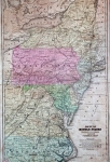
1832.2
MAP OF THE STATES OF PENNSYLVANIA AND NEW JERSEY, London, Published March 15 1832 by I.T. Hinton & Simpken & Marshall; engraved and printed by Fenner Sears & Co. This map also includes Delaware and an inset street plan of Philadelphia, and shows mountains, rivers, towns, cities and rail lines. It is likely the map appearing in Hinton s History and topography of the United States in North America published in 2 volumes in 1832. It is listed in Phillips as also appearing in the 3rd edition of Hinton s History ... London, J. Dowding, 1842. Intaglio print probably from a steel engraving, blank verso, longitude from Greenwich at bottom, from Washington at top. Scale:1 inch = 40 miles. Size: 10 x 15.5 inches. |
 |
1832.3
DER NORDLICHE THEIL DER VEREINIGTEM STAATEN VON NORD AMERICA, NEUE BEARBEITUNG VON AD. ST. 1832. Neue Ausgrabe No. lVII Stieler s Hand-atlas No. 47. Gestochen von Folg: Carl Ausfeld, in Schnepfenthal bey Gotha. Plate 47 from Stieler s Hand-atlas shows the northeast west to Illinois and south to North Carolina. Outline color is used and mountains and rivers are shown accurately. Rhode Island, Maryland, and Delaware are indicated by a letter, with a note giving the full name. Michigan and Wisconsin are still territories. Missouri is off the map, but there is a small inset of the Missouri River with the town of Jefferson, recognizing Missouri as a state. The Maine-Canada border is not correctly shown. This map was also seen in an 1831 edition. An 1865 edition of the atlas carried the title Hand-atlas, uber alle theile der Erde nach dem neuesten zustande und uber das Weltgebaude, herausgegeben von Adolf Stieler, and the atlas this map came from likely had a similar title. Intaglio print probably from a steel engraving, longitude east of Ferro at top, west of Ferro at bottom, also west of Greenwich at bottom. Scale:1 inch = 80 miles. Size: 12 x 15.5 inches. |
 |
1832.4
MAP OF PENNSYLVANIA NEW JERSEY AND DELAWARE COMPILED FROM THE LATEST AUTHORITIES. Philadelphia. Published by S. Augustus Mitchell.1832. This finely engraved pocket map differs from the others shown above with a larger size and wider coverage and the addition of four insets: the Lehigh and Schuylkill coal regions, vicinity of Philadelphia, vicinity of Pittsburg and vicinity of Lancaster. There are many roads, towns, railroads and topographical features noted. This is an early issue not copied from previous Finley pocket maps with an attractive keyboard style border. It is printed on fine banknote paper and folds into a red leather, gilt-stamped cover measuring 3 x 5 inches. A paper label inside the front cover gives the census figures of 1830 for the states by county. Intaglio print, blank verso, longitude from Washington at bottom, from Greenwich at top. Scale:1 inch = 18 miles. Size: 22 x 16.8 inches. |
 |
1832.5
MIDDLE STATES. This school atlas map shows Pennsylvania, New York, New Jersey, Maryland, Delaware, and the eastern parts of Virginia and North Carolina, and is similar to map 1830.9 above. It is undated but dates circa 1831-36 by counties shown. The Columbia and Philadelphia rail line is shown which was just coming into use about this time. The map also shows canals including the Main Line Canal portage rail line from Holidaysburg to Johnstown. This map certainly came from an early school atlas, but which one is not known. A map almost identical to this one came from an atlas published by D.F. Robinson & Co. for geography books by J. Olney, and is the likely source of this map. Intaglio print, blank verso. Scale:1 inch = 45 miles. Size: 16.25 x 10 inches. |
 |
1832.6
MIDDLE STATES, Entered according to Act of Congress on the 9th day of March _ by S.G. Goodrich of Massachusetts, G. Boynton sc. This map has 1830 state census data printed above the title and probably dates from the early 1830s. Goodrich has left the date blank in the copyright notice so the same map could be bound with multiple editions. There is a table of distances from N. York at top left. It was originally bound along the right edge and comes from a Goodrich geography book of the time, though exactly which one is not known. Intaglio print, blank verso, longitude west from Greenwich at bottom, from Washington at top. Scale:1 inch = 110 miles. Size: 4.5 x 6 inches. |
 |
1832.7
OPERATIONS IN PENNSYLVANIA, Vol. ii. p. 38; a map published around 1830 probably for Marshall s Life of Washington. There was an edition by Crissy in 1832, and the probable source of this map. It shows the country from Fort Cumberland and Raystown west to Fort Duquesne, and includes other landmarks of the French & Indian war such as Braddock s Battle, Bouquet s Battle (i.e. Bushy Run), etc. Roads are shown and mountains by hatching. The orientation of the map is somewhat east of north. Intaglio print, blank verso. Scale:1 inch = 12 miles. Size: 9.75 x 6 inches. |
 |
1832.8
UNITED STATES NORTHERN SECTION, Drawn by J. Drayton, engraved by J.H. Young. A hand colored map, plate 36 from Carey and Lea s Family Cabinet Atlas published in Philadelphia in 1832. The northeast is shown from Maine to Virginia and west to include all the Great Lakes. Many towns are named despite the small scale. This same map was used in an 1834 later edition of the atlas. Intaglio print, longitude from Washington at top, from Greenwich at bottom, blank verso. Scale:1 inch = 300 miles. Size: 3.5 x 5.5 inches. |
 |
1832.9
NORTH AMERICA, SHEET III, UPPER CANADA WITH PARTS OF NEW YORK, PENNSYLVANIA, AND MICHIGAN. J. & C. Walker, sc. Published by the Society for the Diffusion of Useful Knowledge. Published September 1st. 1832 by Baldwin & Cradock, 47 Paternoster Row, London. This map is the northern companion to map 1833.6 below. It includes only the northern strip of Pennsylvania including all of the northern tier of counties. The SDUK, as abbreviated, was primarily British, but probably had some American members. It began map publishing under the leadership of Captain Francis Beaufort R.N. in 1829, and published maps in parts (see the 1833, 1834 maps below) over the next 15 years, completing the series in 1844, finally permitting the publication of a complete atlas. Many of the maps were actually drawn by Beaufort, who at the time was the Hydrographer to the Royal Navy, and all were closely supervised by him. J. & C. Walker worked closely with Beaufort in engraving the maps. Finely engraved and delicately colored, these maps set a standard of excellence for commercial map-makers in England for decades to come. The maps they produced beginning circa 1829 were among the first from steel plates prepared by drypoint steel engraving, see Cain. Intaglio steel print. Longitude west from Greenwich, blank verso. Scale: 1 inch = 28 miles. Size: 13 x 18 inches. |
 |
1832.10 PENNSYLVANIA. This anonymous map appeared as a frontispiece in A Gazetteer of the State of Pennsylvania, by Thomas F. Gordon, published by T. Belknap, Philadelphia 1832. The counties are separated by color and roads and canals are shown. The nascent railroad from Philadelphia to Columbia is included. The hand drawn ovals in the east appear meant to indicate coal fields. The book contained geographical and economic information and a list of all the post offices in the state. Gordon put out a similar book for New York. Intaglio print, longitude from Washington at top, from Greenwich at bottom, blank verso. Scale: 1 inch = 18 miles. Size: 19 x 14.5 inches. |
 |
1832.11 UNITED STATES. J.W. Dcl. Stockday Sc. This map appeared in An Atlas, of Modern Geography compiled and drawn from the Latest Observations, by James Wyld. Geographer to His Majesty. London: Published by James Wyld. Charing Cross. 1832. This was an atlas for school use, and this two page map appears on plate 22. Missouri is shown as a state, Arkansas and Michigan are not. The states are outlined in color.The Wylds were an important family of London map publishers and this map was probably prepared by James Senior active circa 1790 to 1836. James Junior entered the family business around 1830. He had royal connections and was geographer to William IV and later to Queen Victoria. He republished some of his father s maps and guided the company towards becoming agents for the Ordnance Survey. He also found time to act as member of parliament for Bodmin. Intaglio print, blank verso, longitude west from Greenwich. Scale: 1 inch = 300 miles. Size: 8.5 x 12 inches. |
 |
1832.12 MAP OF THE UNITED STATES OF AMERICA, AND NOVA SCOTIA, &C.&C. Engraved & printed by Fenner, Sears & Co. This map is almost identical to map 1820.1, however it is somewhat larger, printed from a different plate and has a different title. It is likely the map appeared in Hinton s History and Topography of the United States in North America published in 2 volumes in 1832 by I.T. Hinton, Simpken & Marshall, and is a companion to map 1832.2 above. Intaglio print, probably steel. Blank verso, longitude west from Greenwich at bottom, from Washington at top. Scale: 1 inch = 180 miles. Size: 10 x 15.5 inches. |
 |
1832.13
548. CHARTE VON NORDAMERICA. Grav. V Bergmann. 'V. 12' at bottom right and '100.' at top right. This small German map shows the northeast including all of Pennsylvania. Undated and from Bergmann's Neue Bildergalerie f. Die Jugend..., published by Perthes Justus, Gotha 1832. Maine has incorrect boundaries and the boundaries of some other states are not accurately shown. The city names are in English but the topographical features are not, lake Erie is called 'Erie See' for example. Intaglio print, blank verso, longitude from Washington at top, west from Greenwich or Paris at bottom. Scale:1 inch = 130 miles. Size: 5 x 6.75 inches. |
 |
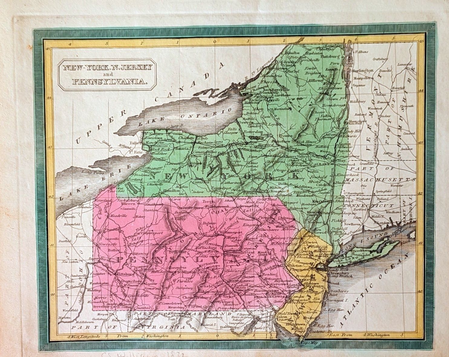
1832.14
NEW-YORK. N. JERSEY AND PENNSYLVANIA. This map is thought to come from A New General Atlas, by Calvin S. Williams (C.S. Williams), New Haven, Connecticut; first edition: 1832. In 1833, the atlas was reissued by Andrus & Judd in Hartford. The states in the title are hand colored. It shows roads, streams, towns, hills by hatching. Intaglio print, blank verso. Longitude from Washington. Scale: 1 inch = 56 miles. Size: 8 x 9.75 inches. |
 |
1833.1
PENNSYLVANIA, page 84 from The School Geography by
John J. Clute. The map dates 1820-31 by the counties
shown. The School Geography by
John J. Clute was published by Samuel Wood &
Sons, New York 1833, with 363 pages, illustrations and
maps according to an LOC listing. The verso is page 83
with text on Pennsylvania. This small map shows outlines
of the counties with each county seat. Longitude from
Washington at top, Greenwich at bottom, blank verso.
Scale: 1 inch = 55 miles. Size: 3.5 x 5.5 inches. |
 |
1833.2
UNITED STATES By David H. Burr. New York. Entered according to Act of Congress in the year 1833 by Illman & Pillbrow. This map comes from Burr's New Universal Atlas and shows the extent of the early United States, with Missouri, Arkansas and Louisiana demarcating the western frontier. A large Missouri territory reaches westward beyond the state, and Huron territory takes the place of Wisconsin and the upper peninsula of Michigan. The southern tip of Florida is shown in an inset at the lower right. the map is filled with early towns, settlements and mines, watershed and some topography. The atlas was also published in 1835 by D.S. Stone, N. York, and included this same map. Intaglio print, blank verso, longitude from Washington at bottom, from Greenwich at top. Scale:1 inch = 135 miles. Size: 10.75 x 12 inches. |
 |
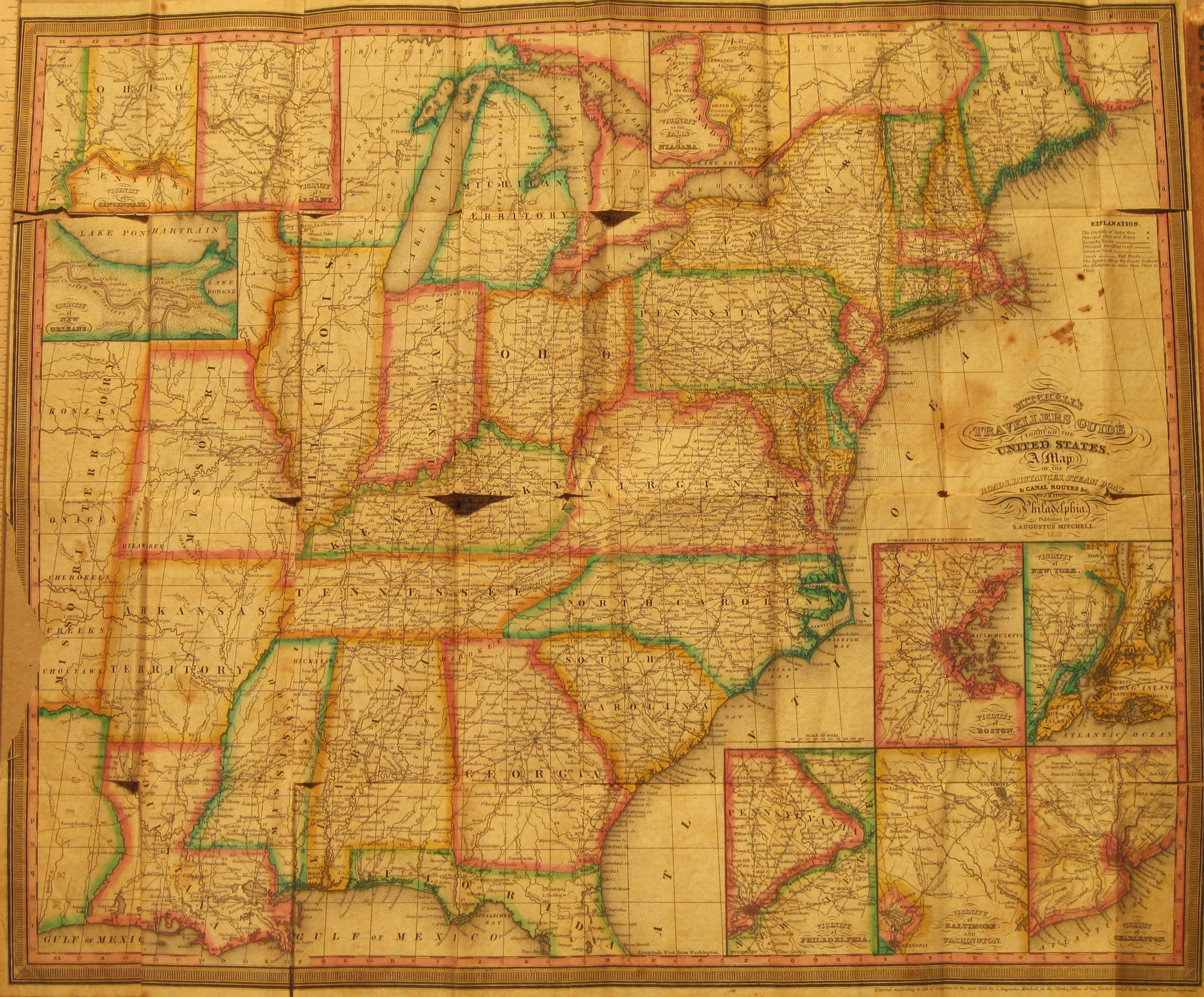
1833.3
MITCHELL'S TRAVELLERS GUIDE THROUGH THE UNITED STATES. A MAP OF THE ROADS, DISTANCES, STEAM BOAT & CANAL ROUTES &C. By J.H. Young, Philadelphia. Published by S. Augustus Mitchell 1833. Engraved on steel by J.H. Young and D. Haines. This is a pocket map with the black 5.25 x 3.25 inch hardback cover having just the first part of the map title. The map (now loose in this copy and with some fold line tears) was attached to the back cover. An index of similar sized is attached to the inside front cover. This index sheet is in better condition than the map indicating not as much use. The map shows the eastern United States with a cutoff Florida and northern Maine. The upper left has insets of New Orleans, Cincinnati, and Albany. At upper center is an inset of Niagara Falls. The lower right has insets of Philadelphia, Washington, Charleston, Boston, and New York city. Intaglio print from a steel plate, blank verso, longitude from Washington. Scale:1 inch = 77 miles. Size: 18 x 21 inches. |
 |
1833.4
A NEW MAP OF PENNSYLVANIA WITH ITS CANALS, RAILROADS, & DISTANCES FROM PLACE TO PLACE ALONG THE STAGE ROADS By H.S. Tanner. Entered in the year 1833 etc; engraved by W. Brose, Philadelphia; published by H.S. Tanner, No. 144 Chestnut St., Philadelphia. This is Plate 11 from 'Tanner's Universal Atlas' as shown along the top edge. It dates 1831-36 by counties shown. This map was drawn in 1833 and published in Tanner s A New Universal Atlas 1833-34, 1836; with Carey & Hart editions in 1842-43, 1844 per Lister. Essentially the same map was published by Mitchell, with the Pennsylvania canal shown in profile at top. Intaglio print, blank verso, longitude from Washington. Scale:1 inch = 24 miles. Size: 10.5 x 13 inches. |
 |
1833.5
.NORTH AMERICA, SHEET VII, PENNSYLVANIA, NEW JERSEY, MARYLAND, DELAWARE, COLUMBIA AND PART OF VIRGINIA. J. & C. Walker, sculp. From the Society for the Diffusion of Useful Knowledge; based on Tanner & Gordon; published July 15, 1833 by Baldwin & Cradock, 47 Paternoster Row, London. It can be dated 1820-1831 by the counties shown. Roads and the few rail lines of the day are shown, and mountains in shaded relief. The companion map which includes a strip of northern Pennsylvania is map 1832.9 above. Intaglio steel print. Longitude west from Greenwich, blank verso. Scale: 1 inch = 28 miles. Size: 18 x 13 inches. |
 |
1833.6
.MAP OF THE UNITED STATES CORRECTED FROM THE MOST AUTHENTIC SOURCES AND PUBLISHED FOR DARBY AND DWIGHT'S GAZETTEER. 1833. Entered according to Act of Congress on the 10th day of May 1831 by Eleazer Huntington of the state of Connecticut. This map shows the country almost to the Rocky Mountains with an inset at left of the Oregon Territory. Arkansas (1836) and Michigan (1837) are still marked as territories. Rivers are shown and mountains by hatching, hand coloring. There is a table of distances at lower right. William Darby and Theodore Dwight, who did other things, joined forces for a few years, circa 1831-36, to put out A New Gazetteer of the United States of America: including ... geographical, historical, political, and statistical information; with the population of 1830, although only an 1836 edition has otherwise been seen. The 1833 edition with this map was published by E. Hopkins, Hartford. Huntington may be the same Eleazer who published a book on penmanship in 1821. The map was attached at the right edge and was orignally folded. Lithograph. Blank verso, longitude from Washington at top, west from London at bottom. Scale: 1 inch = 124 miles. Size: 12.5 x 19.75 inches, |
 |
1833.7
UNITED STATES. An undated and anonymous map that dates somewhere between 1821 (Missouri is a state) and 1836 (Arkansas is not). Maine is cut off at the top but all of Florida is included by extending it beyond the neat line. The map extends west to include all of Louisiana. Rivers and a few towns are named. A distinctive American eagle flies above the title. This map appears to have been attached at the left edge and folded and is printed on light onionskin type paper. It comes from United States Book or, Interesting Events in the History of the United States... by J.W. Barber. New Haven: Published by L.H. Young, 1833. It is a folded frontispiece in the book. Intaglio print, blank verso, longitude from Washington at top, from Greenwich at bottom. Scale:1 inch = 180 miles. Size: 7.75 x 7.5 inches. |
 |
1834.1
NORTH AMERICA INDEX MAP TO CANADA AND THE UNITED STATES,
published Septr. 29th 1834 by Baldwin & Cradock 47
Paternoster Row, London. J. & C. Walker Sculpt. This
is an index map for an atlas put out by the Society for
the Diffusion of Usefull Knowledge. The SDUK (as known)
was primarily British. The maps they produced beginning
circa 1829 were among the first from steel plates
prepared by drypoint steel engraving, see Ristow pages
256, 308. The map covers the east coast west to the
Mississippi. The 1830 census by state (including slaves)
is at lower left; at lower right is the elevation outline
of 5 canals including the Pennsylvania Canal. Many towns
are named. Maps 1832.9 and 1833.6 above are indexed on this map. See Cain for a discussion on the SDUK maps. Longitude west from London, blank verso. Scale:
1 inch = 140 miles. Size: 14.25 x 12.5 inches. |
 |
1834.2
A MAP OF THE ECLIPSES OF FEBY 12 TH, 1831 AND NOV 30TH, 1834. IN THEIR PASSAGE ACROSS THE UNITED STATES, Published by Charles Bowen, Boston. G. Boynton sc. A map likely dating from shortly after 1834; Michigan (1837) is still a territory as is Arkansas (1836). The source is (probably) The American Almanac and Repository of Useful Knowledge for the year 1834, published by Gray & Bowen; which ran circa 1830-60. The map shows the east coast from Maine to Florida and west to the Mississippi. Shaded bands mark the eclipse passage and there are other lines referring to astronomical readings. Rivers and mountains are shown and towns named. See map 1831.3 above for an earlier and similar map. Intaglio print. Longitude from Washington at top, from Greenwich at bottom. Blank verso. Scale:1 inch = 190 miles. Size: 7.5 x 8 inches. |
 |
1834.3
BRITISH POSSESSIONS (NORTH AMERICA) London Published by Orr and Smith Amen Corner Paternoster Row. Drawn & engraved by J. Dower, Pentonville, London. This map is believed to come from The British Cyclop dia of Arts and Sciences, Charles F. Partington, London 1834. It has also been seen dated 1836. The coverage extends from Nova Scotia to Virginia and west to Lake Huron, with an inset of Newfoundland at lower right. The states are named but no boundaries are shown. However, boundaries in Canada are indicated. Intaglio print, possibly from a steel engraving. Blank verso, longitude west from Greenwich. Scale:1 inch = 130 miles. Size: 8.25 x 10 inches. |
 |
1834.4
UNITED STATES NORTHERN SECTION, UNITED STATES SOUTHERN SECTION. Drawn by J. Drayton, engraved by J.H. Young. These two small maps come from The Geographical Annual for 1834, the second edition of A Family Cabinet Atlas published by Carey, Lea and Blanchard in Philadelphia. The atlas is the American edition of the British Sterling Atlas, designed and engraved by Thomas Sterling. The northern map shows the area from Maine to Missouri; the southern from Delaware to east Texas. Though small, the maps have considerable detail, including numerous place names. Intaglio prints with hand color. Blank verso, longitude west from Greenwich at bottom, from Washington at top. Scale:1 inch = 300 miles. Size: 3.5 x 5.5 inches. |
 |
1834.5
ETATS-UNIS, CANADA ET TEXAS, Page 20 showing an anonymous map from an unknown French atlas, dated to 1834 here. Missouri is shown as a state (1821), Arkansas as a territory (1836). Texas is a republic (1845) with an extended northern border and no southern border. The United States is shown west to the Rockies. Lithograph. Blank verso, longitude from Paris. Scale:1 inch = 280 miles. Size: 8 x 10 inches. |
 |
1834.6
UNITED STATES. Published by A. Finley Philada. Young & Delleker sc. The map shows the eastern United States west to beyond the Mississippi. It dates after 1821 since Missouri is a state, but prior to 1836 as Arkansas is shown as a territory. Finley published atlases from the mid 1820s to mid 30s, so the date 1834 is used here though it could be earlier; one dated 1829 and another dated 1832 were seen. Intaglio print. Longitude west from Greenwich at bottom, from Washington at top, blank verso. Scale: 1 inch = 160 miles. Size: 11.5 x 8.75 inches. |
 |
1834.7
A PLAN OF THE FIELD OF BATTLE AND DISPOSITION OF THE TROOPS A THEY WERE ON THE MARCH AT THE TIME OF THE ATTACK JULY 9TH 1755. Engraved for Bancrofts s History of the United States by George G. Smith. A History of the United States, from the Discovery of the American Continent ... by George Bancroft was published by Little, Brown and Company, Boston, over many years beginning in 1834 and what year this map was published is not known, although a copy was seen at auction dated 1852. The history contained many maps like this of French & Indian War and Revolutionary War battles. This one is of Braddock s defeat outside Fort Duquesne. At the top are insets of Fort Duquesne and Fort Pitt which replaced it. The origin of this map is a manuscript map, #1755.27, at the Library of Congress, and a map like this appeared in Jeffreys atlas, #1768.7, in 1768. Intaglio print, Blank verso. Scale: 1 inch ~ 100 yards. Size: 8 x 5 inches. . |
 |
1834.8
CARTE G N RALE DES TATS-UNIS D'AM RIQUE. avec l'indication de la partie navigable de chaque rivi re ainsi que le trac des canaux de navigation et chemins de fer tant ex cut s qu'en ex cution. Dress e par le Major Poussin, pour servir son ouvrage sur les travaux d'am liorations int rieures ex cut s ou projet s par le gouvernement des Etats-Unis de 1824 a 1831. 1834. This large French map shows the eastern United States with southern Florida in an inset at lower right. It comes from Travaux D'Ameliorations Interieues...Etats-Unis D'Amerique...Atlas by Guillaume-Tell Poussin, Paris 1834. This copy has some small hand color red marks whose purpose is unclear, apparently not original. Rail lines, canals, and roads (routes) are shown. Intaglio print. Blank verso, longitude from Washington. Scale: 1 inch = 64 miles. Size: 18 x 22.5 inches. |
 |
1834.9
THE TRAVELLERS GUIDE OR MAP OF THE ROADS, CANALS & RAIL ROADS OF THE UNITED STATES WITH THE DISTANCES FROM PLACE TO PLACE. By H.S. Tanner. Published by H.S. Tanner, 144 Chestnut St. Philadelphia. Entered according to Act of Congress in the year 1834 by H.S. Tanner... . This hand colored map folded into Tanner's Travellers Guide, and may have been used in later editions. A similar map was published by Mitchell, see map 1833.3 above. The map is printed on onionskin type paper and shows the eastern United States with a cutoff Florida and northern Maine. The upper part has insets of Albany, Niagara Falls, and Quebec City. The lower right has insets of Philadelphia, Washington & Baltimore, Charleston, Boston, Richmond, Providence and New York City. The map extends beyond the neat line in places and there is a square inch missing at the bottom on this copy. Intaglio print. Blank verso; longitude from Washington. Scale: 1 inch = 67 miles. Size: 18 x 22 inches. |
 |
1834.10
MAP OF THE CITY OF PHILADELPHIA, Drawn by J. Simons expressly for Phila. as it is in 1834 and published by C.P. Fessenden. This is a detailed map of the downtown with text at right identifying public buildings. References to Fessenden as an early 19th century publisher have been seen, but with no details. This copy has apparently been removed from another work, folded and put into its own marbled paper cover (6 x 3.75 inches) to carry as a pocket map. Intaglio print, blank verso. Scale: 1 inch ~ 2 blocks. Size: 12.5 x 13.75 inches. |
 |
1835.1
PENNSYLVANIA CANALS, RAILROADS, THE COAL REGIONS,
AND NUMBER OF INHABITANTS IN EACH COUNTY OF THE STATE,
engraved for The Casket published by S. C.
Atkinson, J. Yeager Sc. This map comes from S. C.
Atkinson's Casket of Gems of Literature, Wit, and
Sentiment, Philadelphia, January 1835. It can be
dated 1831-36 by counties shown. Distances to major
cities are given across the top and county populations
across the bottom. The 1830's and 40's saw a flurry of 'railroad
and canal' maps (see Modelski) and this is one of the
earliest. The Union Canal along the Schuylkill River and
over to the Susquehanna was built in the 1820's. The
Pennsylvania Canal was begun in 1826 and completed from
the Susquehanna River to Hollidaysburg in 1834, running
along the Juniata River. The western section from
Johnstown to Pittsburgh was begun at the same time and
opened in 1830. It ran up the Allegheny to the
Kiskiminetas River and then up the Conemaugh. Going from
Hollidaysburg to Johnstown required conquering the
Allegheny Front and was accomplished with the famous
Allegheny Portage Railroad, now a National Historic Site,
built 1830-33. Blank verso. Scale: 1 inch = 30 miles.
Size: 8.75 x 12 inches. |
 |
1835.2
MIDDLE STATES. Engraved by J. T. Hammond, N.Y. A hand-colored copperplate engraved map that can be dated 1831-36 by the counties shown and includes Pennsylvania, New York, New Jersey, Maryland, Delaware, and eastern parts of Virginia and North Carolina. Counties are shown and also the topography of mountains, rivers and lakes. Ships illustrated in water areas denote how large a vessel can navigate there. The Erie, Champlain, Lehigh, Delaware, Schuylkill, Union, Penn., Lackawaxen, and Goochland canals are shown, and some railroads. This map is likely from Roswell C. Smith s Atlas for Schools, Academies and Families.. published in 1835 by W. Marshall & Co., Philadelphia (see Lister). Intaglio print, blank verso. Scale: 1 inch = 45 miles. Size: 17 x 10.75 inches. |
 |
1835.3
PENNSYLVANIA AND NEW JERSEY. This map is from A Comprehensive Atlas Geographical Historical and Commercial published by Thos. G. Bradford, Boston, N.Y. and Philadelphia by Ticknor, Wiley & Long, J.J. Ash in 1835. It can be dated 1831-36 by counties shown. The state and county bounderies are in outline color, the canals and railroads are distinguished by line symbols. The Philadelphia and Columbia Railroad (the first state owned railroad) is completed as far as Columbia. It also shows the Allegheny Portage railroad over the mountains. Intaglio print, longitude from Washington at top, from London at bottom, blank verso. Scale:1 inch = 30 miles. Size: 7.75 x 10 inches. |
 |
1835.4
UNITED STATES, EXHIBITING THE RAILROADS & CANALS. This map comes from the same atlas as the one above. It shows the eastern United States west to the Mississippi, with Maine and Florida cut off. Rivers and mountains are indicated and a few towns. Intaglio print, blank verso, longitude from Washington. Scale:1 inch = 150 miles. Size: 7.5 x 9.75 inches. |
 |
1835.5
MAP SHEWING THE OPERATIONS OF THE AMERICAN AND BRITISH ARMIES DURING THE YEARS 1776 AND 1777 IN NEW JERSEY, PENNSYLVANIA AND DELAWARE. This is page 232 from The Family Magazine and it is accompanied by pages 231-236 with an article on the Revolutionary War that the map illustrates. This magazine was published circa 1835-36 by Redfield & Lindsay, New York. This map is based upon map 1807.1; and includes southeastern Pennsylvania, central New Jersey, and northern Delaware with towns and battles identified. Wood engraving set with letterpress text. Scale:1 inch = 18 miles. Size: 4.25 x 6.5 inches (map only). |
 |
1835.6
UNITED STATES. NO. 227 London. Published for the Proprietors, No. 2 Wellington Street, Strand. This map is believed to come from a serialized work called Guide to Knowledge, published in London and edited by William Pinnock circa 1831-35. An engraver named Joshua Archer prepared a large number of maps for Pinnock's Guide circa 1834-35, but this name does not appear on the map. Missouri seems to be recognized as a state, but not Arkansas (1836). The map shows the eastern United States west to beyond the Mississippi. This map is an example of reverse wood engraving printing, and unusual for that reason. Longitude west from Greenwich, blank verso. Scale:1 inch = 300 miles. Size: 6.5 x 9 inches. |
 |
1835.7
ETATS-UNIS DE L'AMERIQUE DU NORD. This anonymous French map is dated circa 1835 as Missouri (1821) is shown as a state while Arkansas (1836) is not. Texas is part of Mexico. The map shows the United States west to the Rocky Mountains. Streams are indicated, along with a few towns. The longitude lines along the right edge are mislabeled and the northern border of Pennsylvania does not indicate the Erie triangle, indicating some haste. The map was bound at the top edge into an unknown volume. Intaglio print, blank verso, longitude west from Paris. Scale: 1 inch = 280 miles. Size: 8 x 10 inches. |
 |
1835.8
UNITED STATES. This map is from the 1835 fourth edition of Huntington's School Atlas by Nathaniel Gilbert Huntington and Eleazer Huntington, published by R. White and Hutchinson & Dwyer, Hartford. This same map appeared in the 1836 edition and probably in others as well. It shows the United States west to the Rockies with a cutoff Florida. In the west are Mandan & Sioux districts (later to become North and South Dakota); District of Huron (western Michigan territory, later Wisconsin); Missouri territory; Osage district; Ozark district; Arkansas territory; and Texas as part of land held by Mexico. There is text in the Missouri district area that states: "Missouri territory is a vast wilderness of immense plains almost destitute of wood except in the neighborhood of streams. It is traversed by numerous herds of buffaloes and wild horses, and by a few roving tribes of Indians." The territories are separated by color and some boundary lines. A table of distances is at lower right. Intaglio print. Longitude from Washington at top, from Greenwich at bottom; blank verso. Scale: 1 inch = 131 miles. Size: 12 x 19 inches. |
 |
1835.9
ETATS-UNIS. V. Levassiur, Geog. Plate 77 from Atlas Classique Universel de G ographie Ancienne et Moderne : avec texte. Compos de 86 cartes dont 9 doubles dress d'apr s les mat riaux les plus r cens par Victor Levasseur g ograph... .This small map comes from an equally small atlas which is undated. A German database dates the atlas circa 1835, the date used here. It may be an update of an earlier 1812 atlas of similar name by Pierre Lapie. Columbus and Indianapolis are shown which would date this map after, say 1825. It shows the United States west to beyond the Mississippi and is so small that little detail is possible. Philadelphia is prominently shown and the finger lakes near Albany amusingly indicated. Blank verso, longitude west from Paris. Scale: 1 inch = 600 miles. Size: 3.5 x 5 inches. |
 |
1835.10
PLAN OF THE WEST-PHILADELPHIA RAIL-ROAD 1835. H.R. Campbell, Engr. On stone by G. Kramm. Lehman & Duval Lith. Philadelphia. The railroad runs from the present station west of the river. It parallels the earlier Columbia & Philadelphia railroad which ran from the downtown. The Lancaster turnpike is also shown. This interesting early railroad map is apparently from some type of report. It comes from the short period, 1834-37, when Peter S. Duval and George Lehman were in partnership. Duval came from France in 1831 to work for the publisher Cephas G. Childs and brought European expertise in lithography to Philadelphia. He partnered with Lehman in 1834 to found Lehman & Duval. Three years later Lehman withdrew from the printing business (though he continued to produce drawings) and the firm became P.S. Duval Lithography at the same location, Dock Street and Bank Alley. It moved to the artisan's building between Chestnut and Market streets from 1848 to 1857. Thus this map is one of the earliest to be printed by lithography in Pennsylvania and probably the earliest map from Duval. The first American lithographic map was produced in 1822 by the firm of Barnet and Doolittle in New York city. The map, "Barton on the Catskills," illustrated an article by Barnet (see Phillips in Woodward). Blank verso. Lithograph. Scale:1"=32 chains (0.4m). Size: 6 x 22 inches. |
 |
1835.11
UNITED STATES. London, Published by John Arrowsmith, No. 10 Soho Square. The number 28 is across the top edge and 29 across the right edge indicating this map was used in at least two publications. John Arrowsmith was the nephew of the better known Aaron Arrowsmith per Lister, and was active in the 1830s and 40s. On this map, Maine (1830) seems to be a state while Arkansas (1836) and Michigan (1837) are not; so it is dated circa 1835 here. An inset of the cutoff Florida is at lower right. Intaglio print, blank verso, longitude west from Greenwich. Scale: 1 inch = 188 miles. Size: 8 x 9.5 inches. |
 |
1835.12
UNITED STATES, EXHIBITING THE RAILROADS & CANALS. This anonymous map is probably from Thomas Bradford s A Comprehensive Atlas , the same source as the Pennsylvania and New Jersey map shown above; the size appears to match and longitude is from Washington indicating an American publisher. It shows the eastern United States west to the Mississippi with Maine and Florida cut off. Arkansas (1836) is shown as a territory. The Lehigh and Columbia railroads are shown and the Pennsylvania Canal; one of the earlier maps to shown rails and canals. It was originally bound at the bottom which has been trimmed. Blank verso, intaglio print, possibly steel plate. Scale: 1 inch = 143 miles. Size: 7.5 x 9.5 inches. |
 |
1836.1
PENNSYLVANIA by David H. Burr, New York. Entered
according to act of Congress 1836 by Illman & Pilbrow.
The map can be dated 1820-31 by counties shown. It is
likely from Burr's A New Universal Atlas
published by D. S. Stone, New York, and dated c1835 by
Lister. Burr was appointed to be topographer to the U.S. Post Office Department in 1832 and was unable to complete the maps for his atlas. Thomas Illman assumed responsibility to complete the atlas, publishing it using the New York firm of D.S. Stone. There were at least two editions in 1835 and 1836, and then the atlas was taken over by other publishers. Blank verso. Scale: 1 inch = 25 miles. Size: 12 x
13.5 inches. |
 |
1836.2
PHILADELPHIA. Published by Carey & Hart Philadelphia. Entered according to the Act of Congress in the year 1836 by Henry S. Tanner . This map is page 14 from Tanner s Universal Atlas and shows the downtown area. Index to buildings lies along right side and an index to wards is under the title. Intaglio print, blank verso. Scale:1 inch = 1400 feet. Size: 15 x 12.5 inches. |
 |
1836.3
UNITED STATES. Drawn & Engraved by I. Dower, Pentonville London. London: Published by Orr & Smith Amen Corner Paternoster Row. This copper-plate engraved map of the United States is from The British Cyclopedia of Literature, History, Geography, Law, and Politics, (Third Volume of Three) by Charles F. Partington published by Orr and Smith in 1836. It shows the United States, parts of Canada/British America and the Bahamas. The United States is divided into the states & territories of the time, and extends from Maine to Florida and west to just beyond the Mississippi. Arkansas appears to be a state but not today s Michigan which would date it 1836-37. The borders of some states are different from today. Only one Virginia - no West Virginia, Maine shows two borders with Canada. The names of Indian tribes and various forts appear. A tinted version of this same map was seen as being from A New General Atlas of Modern Geography published 1836, London. Intaglio print, longitude from Greenwich, blank verso. Scale:1 inch = 175 miles. Size: 10.25 x 8.25 inches. |
 |
1836.4
CARTE DES ETATS-UNIS D'AMERIQUE 1836. Gravee sur Pierre par L. Bouffard Rue du Regard 19. Lith. De Benard Rue de l'Abbaye, No. 4; probably published in 1837. This map was originally folded and attached at upper left, and shows the United States from Maine to a cutoff Florida and west to beyond the Mississippi. Apparently someone's travel route is marked in color. Boat and train (chemins de fer) routes are shown, and the "Route Nationale". Hand colored showing "voies de communication" in five colors. Lithograph, blank verso, longitude west from Paris. Scale:1 inch = 130 miles. Size: 12 x 15 inches. . |
 |
1836.5
(PENNSYLVANIA) This untitled newspaper map appeared on the front page of the New-York American on Friday evening, October 28, 1836. Vol. XVIII, No. 5623. It was included to illustrate an article about the Battle of Lake Erie, part of the War of 1812. The map, however, is current and interesting for showing canal and rail lines of this date. Scale: 1 inch ~ 50 miles. Size: 8 x 9.5 inches. |
 |
1836.6
CARTE GENERALE DES ETATS-UNIS DES HAUT ET BAS-CANADA, DE LA NOUVLE. ECOSSE, DU NOUVAE. BRUNSWICK, DE TERRE-NEUVE &C. Seconde Edition par A. Brue (Adrian Hubert Brue), Geographe du Roi. Paris 1836. Plate No. 34, No. 58; so apparently the map was prepared to appear in two different atlases. This map is from Atlas Universel de Geographie Physique, Politique et Historique, published by Brue in editions from the 1830s to 1850s. It shows the United States to well beyond the Mississippi, southern Florida is cut off and appears in an inset at lower right along with one of Newfoundland. Arkansas (1836) is shown as a state. Intaglio print with hand outline color. Blank verso, longitude west from Paris. Scale: 1 inch = 111 miles. Size: 14 x 20 inches. |
 |
1836.7
(UNTITLED) Map of the Beaver River junction with the Ohio River, by M.R. Stealey. Molineux sc. Pitt. The date and source of this map are not known and its purpose is also unclear. It has been seen dated 1836 so that date is used here. The inset map shows canals in western Pennsylvania and eastern Ohio, so it was prepared during the canal era before railroads became widespread, say circa 1820-40. Its purpose may have been to illustrate the possibility of a canal along the river. The Beaver River is shown from its mouth to Brighton and other towns in the area, including Beaver the county seat, are identified. It was originally folded into a book. Intaglio print. Blank verso. Scale: 1 inch = 0.5 miles. Size: 6 x 11 inches. |
 |
1837.1 N.
JERSEY, PENNSYLVANIA DELAWARE & MARYLAND, entered
according to Act of Congress on the 9th day et March _ by
S. G. Goodrich of Mass. The map can be dated 1831-36 by
the counties shown. Goodrich published The First Book
of History for Children and Youth using the
pseudonym Peter Parley circa 1837, which contained many
maps and is the likely source of this one. A copy
published by Jenks, Palmer & Co., Boston, was dated
1839 and contained a map with this title. Early rail
lines west to Harrisburg and north to New York from
Philadelphia are shown. Goodrich was a prolific publisher
of children's books, most of them with the nom de plume
of Peter Parley, see Michalski. Blank verso. Scale: 1
inch = 72 miles. Size: 4.5 x 6 inches. |
 |
1837.2
ETATS UNIS ET CANADA, dresses par C.V. Monin. Paris, Aurmand Aubree, Editeur, Rue Taranne,14. Grave' sur acier par l. Grenier, Rue des Noyers, No. 33. Imprime' par Mangeon. Ecrit par Benard, Rue St. Jacque, No. 51. Plate 10.bis believed to be from L'univers. Atlas classique et Universel de G ographie Ancienne et Moderne par M. Monin, ... & M. Fr min, ... ; Paris : Aurmand Aubr e, 1837. Missouri (1821) appears as a state while Arkansas (1836) and Michigan (1837) are still territories, so circa 1822-37. Inset of southern Forida at lower right. Shows the eastern United States and southern Canada from Nova Scotia to Florida and west to beyond the Mississippi. It appears to be a steel plate engraving. Blank verso, longitude west from Paris. Scale:1 inch = 131 miles. Size: 12 x 18 inches. |
 |
1837.3
ETATS-UNIS par Th. Duvotenay, geographe. This map shows the eastern United States west as far as Texas, the Rio Rrande and the Rocky Mountains. Engraved by Thomas Duvotenay and published in the 1837 edition of L'univers, ou Histoire et Description de tous les Peuples, de leurs Religions, Moeurs, Coutumes, etc Etats-Unis d'Amerique (The universe, history and description of all the peoples, their religions, mores, customs, etc. of the United States of America) by M. Roux de Rochelle, Paris. Roux de Rochelle served as French minister to the United States and this work is a well known piece of early Americana on a variety of subjects: native Americans, early American settlers, politics, etc. Arkansas (1836) is named but boundaries not accurate. Intaglio print, possibly a steel engraving. Blank verso, longitude from Paris. Scale:1 inch = 280 miles. Size: 7 x 9 inches. |
 |
1837.4
UNITED STATES, Engraved for Ewing's General Atlas, by J. & G. Menzies, Edinburgh. Page 25. A map of the eastern United States which shows a reduced Maine, and Florida extending beyond the neat line. Missouri (1821) is named as a state but not Arkansas (1836). Ewing produced atlases from circa 1820 to 1860. The title page of the atlas from which this map comes is undated but the name matches the Ewing atlas for 1837 per a library listing, so that date is used here; however it is possible the same map was used in an earlier atlas. It could date as early as 1824 as Arkansas is shown as including Oklahoma territory (separated 1824). The atlas title is Ewing's New General Atlas: containing distinct maps of all the principal States and Kingdoms throughout the World, published by Oliver & Boyd, Edinburgh. Intaglio print, blank verso, longitude from Greenwich. Scale:1 inch = 215 miles. Size: 7 x 8.5 inches. |
 |
1837.5
PHILADELPHIA AND ENVIRONS. This two page map appeared in The American Traveller; or Guide through the United States,by H.S. Tanner, Third edition. Philadelphia: Published by the author, No. 51 South Third Street. 1837. Maps of Boston, New York, and Baltimore were also included along with illustrations. This map has considerable detail. The large letters identify city districts and a list of numbered buildings is at bottom left. The wharves are named. Intaglio print, blank verso. Scale: 1 inch = 0.5 mile. Size: 7.5 x 6 inches. |
 |
1838.1
THE TOURIST POCKET MAP OF PENNSYLVANIA EXHIBITING ITS
INTERNAL IMPROVEMENTS, ROADS, DISTANCES, &C., by J. H.
Young, D. Haines Sc., published by S. Augustus Mitchell,
Philadelphia 1838. Most of the map is shown here along
with the cover. It has a profile of the Pennsylvania
Canal across the top and insets of Philadelphia and the
Lehigh and Schuykill coal regions. This particular map
design, with the canal profile across the top, was
printed in various forms by several publishers (Mitchell,
Tanner, Cowperthwait) from the 1830's to the 1860's. The
design was not unique to Pennsylvania, some maps of
Maryland and Virginia had the profile of the Chesapeake
and Ohio Canal along the top. The map is printed on
vellum type paper (apparently thought to resist folding
better) and folds into the 5 x 3 inch leather cover with
the title shown. This is one of the famous traveler's
pocket maps popular in the 19th century and Mitchell
published his first one of Pennsylvania in 1832. S. A.
Mitchell, along with his son S. A. Junior, was one of the
most prolific map publishers of the century, see Ristow.
Similar to No. 350 in Simonetti. Blank verso. Scale: 1
inch = 25 miles. Size: 12.75 x 15 inches. |
 |
1838.2
PENNSYLVANIA, Entered according to Act of Congress in the year 1838 ..etc, engraved by G. W. Boynton. This map is from Thomas Gamaliel Bradford's An Illustrated Atlas, Geographical, Statistical, and Historical of the United States and the adjacent countries, E. S. Grant & Co. Philadelphia 1838. It can be dated 1836-39 by the counties shown. The same map also appeared in Bradford and S. G. Goodrich s A Universal Illustrated Atlas of the World 1841, 1842, 1843 per Phillips. The Pennsylvania Canal and the National Road are shown and named, shows rail lines. Intaglio print. Longitude from Washington, blank verso. Scale:1 inch = 23 miles. Size: 11.5 x 14 inches. |
 |
1838.3
CHART OF THE EASTERN PART OF PRESQU ILE BAY SHOWING THE CHANGES OF OUTLINE OF SHORE GOING ON IN CONSQUENCE OF THE ERECTION OF THE U.S. WORKS, copied in part from Lieut. T. S. Brown s map of 1835 by J. H. Simpson, 1st. Lieut. U. S. Topogt. Engrs. Oct. 1838. W. J. Stone, sc. Wash. Accompg. Annual report 1838 W. G. Williams Capt. U. S. Top. Engs. This map shows the entrance to the bay and part of downtown Erie in outline. The works referred to are a breakwater constructed across the entrance. Originally folded. Lithograph. Blank verso. Scale: 1 inch = 700 feet. Size: 16 x 16 inches. |
 |
1838.4
MIDDLE STATES. This map shows Monroe but not Clinton county, so it dates 1836-39. It is distinguished by a small engraving titled Penn s Treaty, showing Penn and Indians and based on the famous painting by Benjamin West. The coverage includes New York, Pennsylvania, New Jersey, Delaware, Maryland, Virginia, North Carolina and parts of South Carolina and Ohio. It is similar to other middle states maps from the 1830 s, but not the same; and this view shows most, but not all of the map. The Library of Congress has The Encyclopaedia of Geography ... on the plan of Murray's Encyclopaedia of Geography ... by Thomas T. Smiley. Hartford, Belknap & Hammersley; Philadelphia, Grigg & Elliot, 1838, which is the likely source of this map. Intaglio print with illustration. Longitude from Washington, blank verso. Scale:1 inch = 47 miles. Size: 16 x 10 inches. |
 |
1838.5
PHILADELPHIA. Entered according to Act of Congress in the year 1838 ..etc, engraved by G. W. Boynton. This map is from Thomas Gamaliel Bradford s An Illustrated Atlas, Geographical, Statistical, and Historical of the United States and the adjacent countries, E. S. Grant & Co. Philadelphia 1838; the same atlas as map 1838.2 above. The built up area is indicated by shading and the penitentiary is shown. Intaglio print, blank verso. Scale: 1 inch = 1300 feet. Size: 14 x 11.5 inches. |
 |
1838.6
MAP OF PENNSYLVANIA by Spencer & Co. Philadelphia. 1838. Drawn and Engraved by Ely & Hammond, N. York. Entered... in the year 1836 by H. Phelps & H.S. Squire. This linen backed wall map appears derived from other maps of the time, i.e. Melish, Tanner and Mitchell. Inset plans show Harrisburg & Vicinity, Lehigh and Schuykill Coal Region, Pittsburgh, Harrisburg, Philadelphia, South Easton. There is a Profile of the Pennsylvania Canal and pictorial Scale of Mountains. A reference key denotes county seats, large and small towns. churches, mills, manufactories, furnaces, forges, minerals and post offices. The map has a wide oak leaf border and is decorated with vignettes illustrating Penn's Treaty with the Indians and Pennsylvania Coat of Arms. Murphy Smith cites an 1839 edition held at the American Philosophical Society; OCLC cites only a single 1839 edition. An unusual map and apparently rather rare. This copy lacks rods and has short tears with some marginal loss and scattered damp stains. The sticker at lower right is not original. Intaglio print with a dark varnished surface, blank verso, longitude from Washington. Scale: 1 inch = 13 miles. Size: 21.5 x 32 inches. |
 |
1839.1
MAP OF PRESQU' ILE BAY ON ERIE HARBOR, surveyed by
Capt. W. G. Williams, U. S. Topl. Engs. 1839. This is a
black & white map of the Erie harbor, with the city
shown only figuratively. The western side of the isle is
eroded and a proposed harbor entrance shown. This
entrance was never constructed; instead the area was
filled in with a breakwater and a road built out onto the
island turning it into a peninsula. Today Presque Isle is
a state park, and constant maintainance is needed to keep
this area from washing away. Blank verso. Scale: 1 inch =
2000 feet. Size: 10 x 17 inches. |
 |
1839.2
MAP OF THE MIDDLE STATES DESIGNED TO ACCOMPANY SMITH S GEOGRAPHY FOR SCHOOLS, Entered according to Act of Congress in the year 1839 by Daniel Burgess . Printed by Stiles, Sherman & Smith, N. Y. This map can be dated 1840-43 by counties shown and so has been updated from the date on the map. Cady & Burgess published Roswell C. Smith s geography in 1839, 1850 per Lister, but there were likely other editions. This map likely comes from an atlas accompanying the geography also published by Cady & Burgess. The coverage includes Pennsylvania, New York, New Jersey, Delaware, Maryland, and the eastern parts of Virginia and North Carolina. It is similar to the 1835 and 1838 maps shown above and this was a common map design for this period. This copy has some pieces missing along the binding line. Intaglio print, blank verso. Scale:1 inch = 45 miles. Size: 17.5 x 10.5 inches. |
 |
1839.3
UNITED STATES. There is "5." at top right; and "Entered according to Act of Congress in the year 1839 by H.S. Tanner..." at bottom. The map is likely from H.S. Tanner's New Universal Atlas published in Philadelphia circa 1840 by Carey & Hart. It is a map of mid 19th century United States with an attractive green rope border; and shows roads, canals, railroads. All of Maine and Florida are included and coverage extends west to include the states of Missouri and Arkansas. Intaglio print, blank verso. Longitude from Washington. Scale:1 inch = 125 miles. Size: 15 x 12 inches. |
 |
1839.4
MAP AND PROFILE OF THE GETTYSBURG RAIL ROAD. As surveyed by order of the Legislature of Pennsylvania 1839. H.R. Campbell, Engineer. P.S. Duval, Lith. Phila. This early railroad map shows proposed tracks running from Gettysburg, at the right, west and then south to Big Spring, Maryland and the Potomac River. The route is shown with topographical detail in the immediate vicinity of the tracks. At bottom is a profile view of the elevation change. Only the middle section with the title is shown here from this long and narrow map printed on light paper with some age darkening in this copy. Lithograph, blank verso. Scale:1 inch = 1.25 miles. Size: 12 x 33 inches. |
 |
1839.5
DIE COLONIEN DER ENGL NDER IN NORD-AMERICA VOR UND IM REVOLUTIONS-KRIEGE von Joh. Val. Kutscheit. This German map of the northeast is from Historisch-geographischer Atlas zu den allgemeinen Geschichtswerken von C. v. Rotteck, P litz u. Becker : in 40 colorirten Karten von Julius L wenberg. Gest. von F. Bohnert. Lithographie von B. Herder in Freiburg im Breisgau 1839 (Historical-geographical Atlas of the general histories of C. v Rotteck, P litz u Becker: In 40 color cards by Julius Loewenberg. Gest. of F. Bohnert. Lithography by B. Herder in Freiburg im Breisgau). This source was found in a German library search. There were later editions, in 1844 and circa 1850. Inset of Boston harbor at right, and a table with important events and dates from the Revolutionary War. Lithograph. Blank verso, longitude east from Ferro at top, west from Ferro at bottom. Scale:1 inch = 162 miles. Size: 10 x 13 inches. |
 |
1839.6
NO. 11 MAP OF THE MIDDLE STATES AND PART OF THE SOUTHERN. Engraved to illustrate Mitchell s School and Family Geography, entered according to Act of Congress in the year 1839 by S. Augustus Mitchell etc. This map includes Pennsylvania, New York, New Jersey, Maryland, Delaware, Virginia, and parts of West Virginia and North Carolina. Although dated 1839, this map was printed between 1850 and 1855 by counties shown; West Virginia is not separated from Virginia. It resembles map 1839.2, which Mitchell apparently took over and used. There is also a similar map labeled 'No. 7.' intaglio print. Longitude from Washington, blank verso. Scale: 1 inch = 45 miles. Size: 17.5 x 10.5 inches. |