


| WELCOME | Articles on Historical Maps of Pennsylvania | WELCOME |
Pennsylvania in Early Pocket Maps Circa 1825 - 1874
|
|
1823 (circa) PENNSYLVANIA, B. T. Welch & Co. Sc. This map is from Fielding Lucas Jr., and is the same map ( see map 1823.1) that appeared in his A General Atlas containing distinct maps of all the known countries in the world, Fielding Lucas Jr., Baltimore 1823. So, this pocket map version is dated the same here; and which if so, would make it the earliest pocket map of Pennsylvania seen. It appears to come from the same plate as the atlas map and folds into a hard paper 5 x 2.75 inch reddish cover titled 'Pennsylvania.' On the inside front cover is an ad for Lucas maps. Roads shown, and mountains in shaded relief. Intaglio print on onionskin type paper. Blank verso. Scale: 1 inch = 20 miles. Size: 11 x 17.5 inches. |
|
|
1826 PENNSYLVANIA, Published by A. Finley Philada. Young & Delleker sc. This pocket map has the date on the inside of the 3.5 x 2 inch leather cover; which also gives the address of Finley's business. It is similar to the map from the 1824 Finley atlas and this is one of the earliest pocket maps of Pennsylvania seen. Roads are shown by very light black line and a few canals are named, but no railroads. The map is printed on onion skin type paper and this copy is in only fair condition, a couple small pieces are missing and it is fragile. There is also a tape repair on the cover seam. Blank verso, longitude from London at bottom, from Washington at top. Scale: 1 inch = 30 miles. Size: 8.5 x 11 inches. |
|
|
1827 PENNSYLVANIA. Philadelphia: Published by Robert De Silver 1827. "Plate 14" at top right. This map is almost identical to map 1814.1 from Matthew Carey s General Atlas. Editions of this atlas appeared in 1796, 1802, 1814, 1817, 1818 per Lister and this map was probably copied from one of the later editions. The differences from the 1814 map are the De Silver imprint at bottom and in the outer neat line, and in the hand outline coloring of the counties. This impression also appears just slightly smaller, which may indicate a different plate or possibly just shrinkage. This pocket map version is printed on onionskin paper, typically used only for pocket maps, and folds into a red cardboard 5 x 2.75 inch cover. The fact that the plate number 14 appears would indicate the atlas plate was used. Given its pre-1820 origin, this version might be considered the earliest pocket map issued in the United States. Blank verso. Scale: 1 inch = 14 miles. Size: 11.5 x 18 inches. |
|
|
1829 PENNSYLVANIA, Published by A. Finley Philada. Young & Delleker sc. This pocket map has the date on the inside of the 3.5 x 2 inch leather cover; which also gives the address of Finley's establishment. It is very similar to the earlier Finley pocket map shown above and to the 1824 atlas map, and this is a case where an atlas map plate has been used to produce a pocket map. The map is printed on onion skin type paper and is in better condition than the earlier version above. Blank verso, longitude from London at bottom, from Washington at top. Scale: 1 inch = 30 miles. Size: 9 x 11 inches. |
|
|
1830 SCHUYLKILL COUNTY, PENNSYLVANIA. This is believed to be the map published by H. S. Tanner circa 1830 from a plate prepared originally by John Melish. Melish was appointed (or charged) by the state to prepare a large state map which he published in 1822 with subsequent editions. He used county maps prepared by a number of other draftsmen, and manuscript copies of some of those county maps are still held in the Pennsylvania archives. Melish planned to issued an atlas of county maps but only engraved (or had engraved) about eight of them before dying in 1822. This map is thought to be one of those maps. The plates were later acquired by Tanner and subsequent copies produced around 1830. This copy, printed on heavy paper, has been formed into a pocket map with a 4 x 2.5 inch red leather cover titled Schuylkill County.' The inside cover has an autograph with the date 1829; Stephenson, in his listing of Library of Congress maps, dates it to 1830. So, either this is the earlier Melish printing (doubtful) or a hot-off-the-press circa 1830 version. See the Early County Maps page for more on the Melish county maps. The fancy red cover with gilt and the close trimming to the neat line would indicate this copy was intended and printed as a pocket map. Blank verso, longitude from Washington. Scale: 1 inch = 2 miles. Size: 15.5 x 21.5 inches. |
|
|
1830 MAP OF PENNSYLVANIA NEW JERSEY AND DELAWARE CONSTRUCTED FROM THE LATEST AUTHORITIES, published by S. Augustus Mitchell, Philadelphia. Engraved by J.H.Young. This undated pocket map has a 6 x 3.5 inch faded reddish cover to which it is attached. 1820 census data is used which matches the dating 1820-31 inferred from the counties shown; so, it is dated circa 1830 here as this seems the earliest a Mitchell map like this could appear. Roads are shown by very light black line and a few 'proposed' canals and railroads. A list of counties with population appears at lower left. The map has the attractive 'piano key' border seen on other Mitchell maps of this time. Onion skin type paper. Blank verso, longitude from Washington at bottom, from Greenwich at top. Scale:1 inch = 18 miles. Size: 17 x 21 inches. |
|
|
1830 THE TRAVELLERS POCKET-MAP OF PENNSYLVANIA WITH ITS CANALS, RAIL-ROADS & DISTANCES FROM PLACE TO PLACE ALONG THE STAGE ROADS, by H.S. Tanner. Entered according to Act of Congress the 1st day of March, 1830 by H.S. Tanner. Engraved by W. Brose, Philadelphia 1830. This pocket map is printed on ordinary paper and trimmed close to the neat line. It was probably printed by an atlas plate and is very similar to map 1833.4 (in 19th century maps) except for the date. This is probably the earliest map of Pennsylvania alone and the earliest pocket map from Tanner. A profile of the Pennsylvania canal runs along the top and a Table of Distances is at lower left. Maps similar to this were published until the 1840s. This copy folds into a 4 x 2.5 inch red leather and cardboard cover with the title 'Penna. Canals.' Blank verso, intaglio print. Longitude from Washington. Scale: 1 inch = 24 miles. Size: 10.5 x 13 inches. |
|
|
1831 THE TOURIST'S POCKET MAP OF PENNSYLVANIA EXHIBITING ITS INTERNAL IMPROVEMENTS ROADS DISTANCES &C. By: J. H. Young. Philadelphia. Published by S. Augustus Mitchell. 1831 D. Haines sc. Entered according to Act of Congress April 15th 1831... .This map on vellum paper folds into a 3 x 5 inch brown leather cover with the title Pennsylvania. There are insets of 'Lehigh and Schuylkill Coal Regions' and 'Vicinity of Philadelphia' at bottom. Many roads, towns, railroads and topographical features are noted; the profile of the Pennsylvania Canal is shown at the top which became a fixture on Mitchell's Pennsylvania maps into the 1850s. A paper label inside the front cover gives the census figures for 1830. The map has some damage with a long tear along one fold line. Blank verso, longitude from Greenwich at bottom, from Washington at top. Scale: 1 inch = 25 miles. Size: 12.5 x 15 inches. |
|
|
1832 MAP OF THE STATE OF PENNSYLVANIA COMPILED FROM THE LATEST AUTHORITIES. Published by S. Augustus Mitchell Philadelphia 1832. This map can be dated 1820-31 by the counties shown. It contains inset maps of Philadelphia and 'Pittsburg' vicinities, and folds into a 3.5 x 2 inch red leather case, embossed with gilded lettering, and with the title Pennsylvania Traveller . The map is attached to the back cover and on the inside front cover is Mitchell s Philadelphia address. This is a different map and smaller than the 1831 map above. It has no 'tourist' reference and so may have been printed from an atlas plate on onionskin paper. Roads are shown with distances between points, no rail lines. This copy had one panel separated with crease tears, since repaired. There is a signature on the verso dated 1833. Blank verso, longitude from Washington. Scale: 1 inch = 30 miles. Size: 8 x 10.5 inches. |
|
|
1833 MITCHELL'S TRAVELLERS GUIDE THROUGH THE UNITED STATES. A MAP OF THE ROADS, DISTANCES, STEAM BOAT & CANAL ROUTES &C. by J. H. Young, Philadelphia. Published by S. Augustus Mitchell 1833. Engraved on steel by J. H. Young and D. Haines. Entered according to Act of Congress in the year 1832.. . The black 5.25 x 3.25 inch hardback cover has just the first part of the map title. The map is attached to the back cover. An index of similar size is attached to the inside front cover. The index sheet is in good shape in this copy as if not used as much, while the map has some separation along the fold lines, though printed on onionskin type paper. The map shows the eastern United States with a cutoff Florida and northern Maine. The upper left has insets of New Orleans, Cincinnati, and Albany; at upper center is an inset of Niagara Falls. The lower right has insets of Philadelphia, Washington, Charleston, Boston, and New York City. The notation "engraved on steel" would make this one of the earliest American maps to be printed from such a plate, and would indicate Mitchell intended to print many copies; the 1832 first edition is identical to this one except for the date under the title. Blank verso, longitude from Washington. Scale:1 inch = 77 miles. Size: 18 x 21 inches. |
|
|
1836 A NEW MAP OF PENNSYLVANIA WITH ITS CANALS, RAIL-ROADS & DISTANCES FROM PLACE TO PLACE ALONG THE STAGE ROADS. By H. S. Tanner. Entered according to Act of Congress in the year 1836 by H. S. Tanner.. . Published by H. S. Tanner No. 144 Chesnut St. Philadelphia. Engraved by W. Brose, Philadelphia. This map folds into a 4.25 x 2.5 inch brown cover with the title Tanner s Traveller s Map of Pennsylvania on green pasted paper. Across the top of the map is Tanner s Universal Atlas indicating that an atlas plate was used to print this pocket map on onionskin paper. The Pennsylvania Canal profile is along the top and an inset table of distances is at the bottom. Main roads are shown. On the inside is written in ink Curtis Spalding bought May 12, 1837 in Philadelphia price 42 ct. Blank verso, longitude from Washington. Scale:1 inch = 25 miles. Size: 10.75 x 13 inches. |
|
|
1838 THE TOURIST POCKET MAP OF PENNSYLVANIA EXHIBITING ITS INTERNAL IMPROVEMENTS, ROADS, DISTANCES, &C. By J. H. Young, Published by S. Augustus Mitchell, Philadelphia 1838. Entered according to Act of Congress April 15th, 1831 by S. Augustus Mitchell etc. D. Haines, sc. This is a later version of the 1831 first edtion map shown above. It dates 1836-39 by the counties shown; Juniata and Monroe counties have been added to the map otherwise it is the same as the 1831 version. It is printed on vellum paper and folds into a 5 x 3 inch brown leather cover with the title Mitchell s Map of Pennsylvania.' The inside cover lists the county census of 1830 just as the map above, however a different cover is used. Blank verso, longitude from Greenwich at bottom, from Washington at top. Scale: 1 inch = 25 miles. Size: 12.5 x 15 inches. |
|
|
1843 THE TOURIST S POCKET MAP OF PENNSYLVANIA EXHIBITING ITS INTERNAL IMPROVEMENTS ROADS DISTANCES &C. By J. H. Young Philadelphia. Published by S. Augustus Mitchell 1843. Entered according to Act of Congress April 15th 1831.. .Sold by Thomas, Cowperthwait & Co. No. 253 Market Street. D. Haines Sc. This is a later edition of the 1831 map shown above. Despite being printed on onionskin type paper, this map has tears and some missing paper at the fold lines.Insets of Lehigh and Schuylkill Coal Regions and Vicinity of Philadelphia are at the bottom; and at top is Profile of the Pennsylvania Canal. Roads, rail lines and canals are shown including the famous Allegheny Portage railroad. The map folds into a 5 x 3 inch red cardboard cover with a handwritten inscription dated 1843 on the inside. Blank verso, longitude from Washington at top, Greenwich at bottom.Scale:1 inch = 23 miles. Size: 12.5 x 15 inches. |
|
|
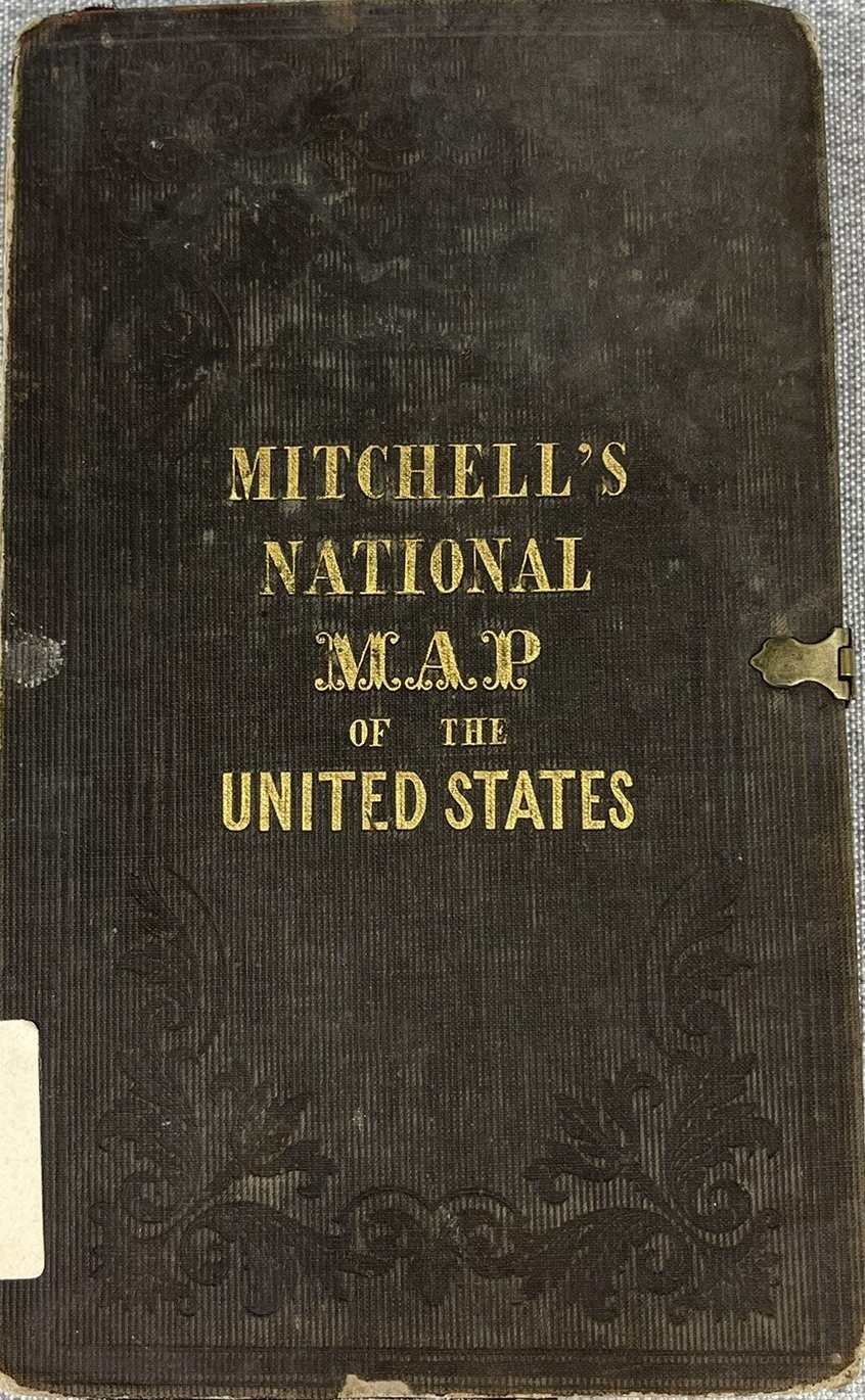
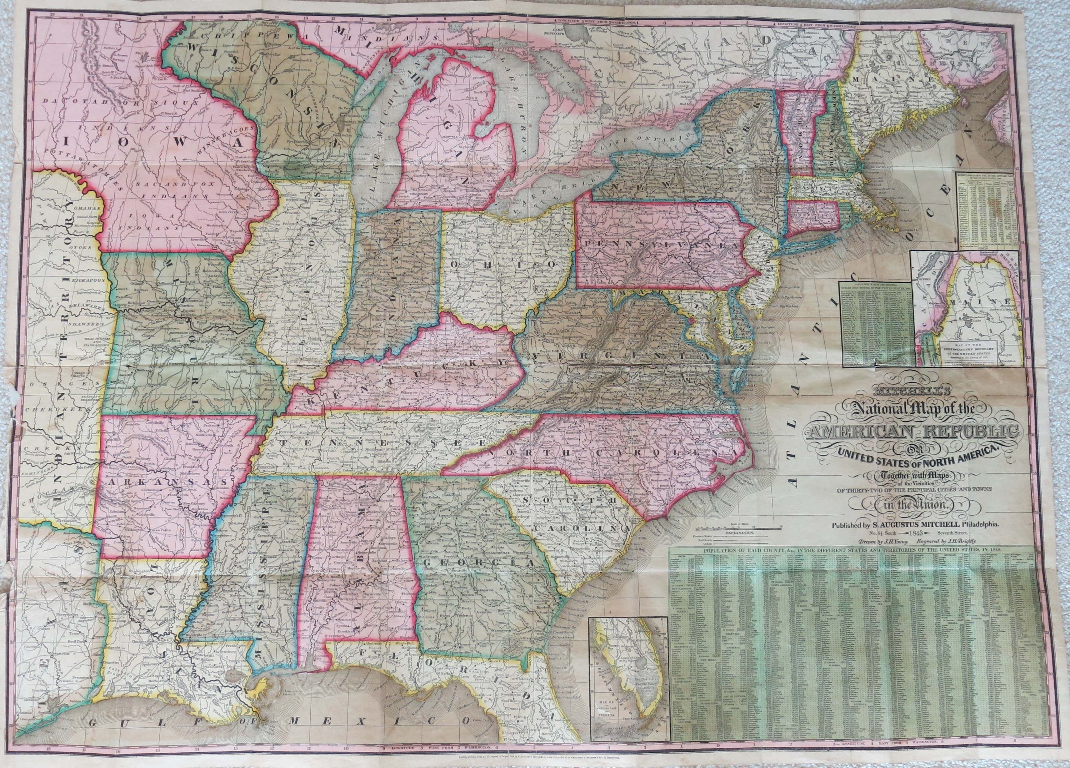
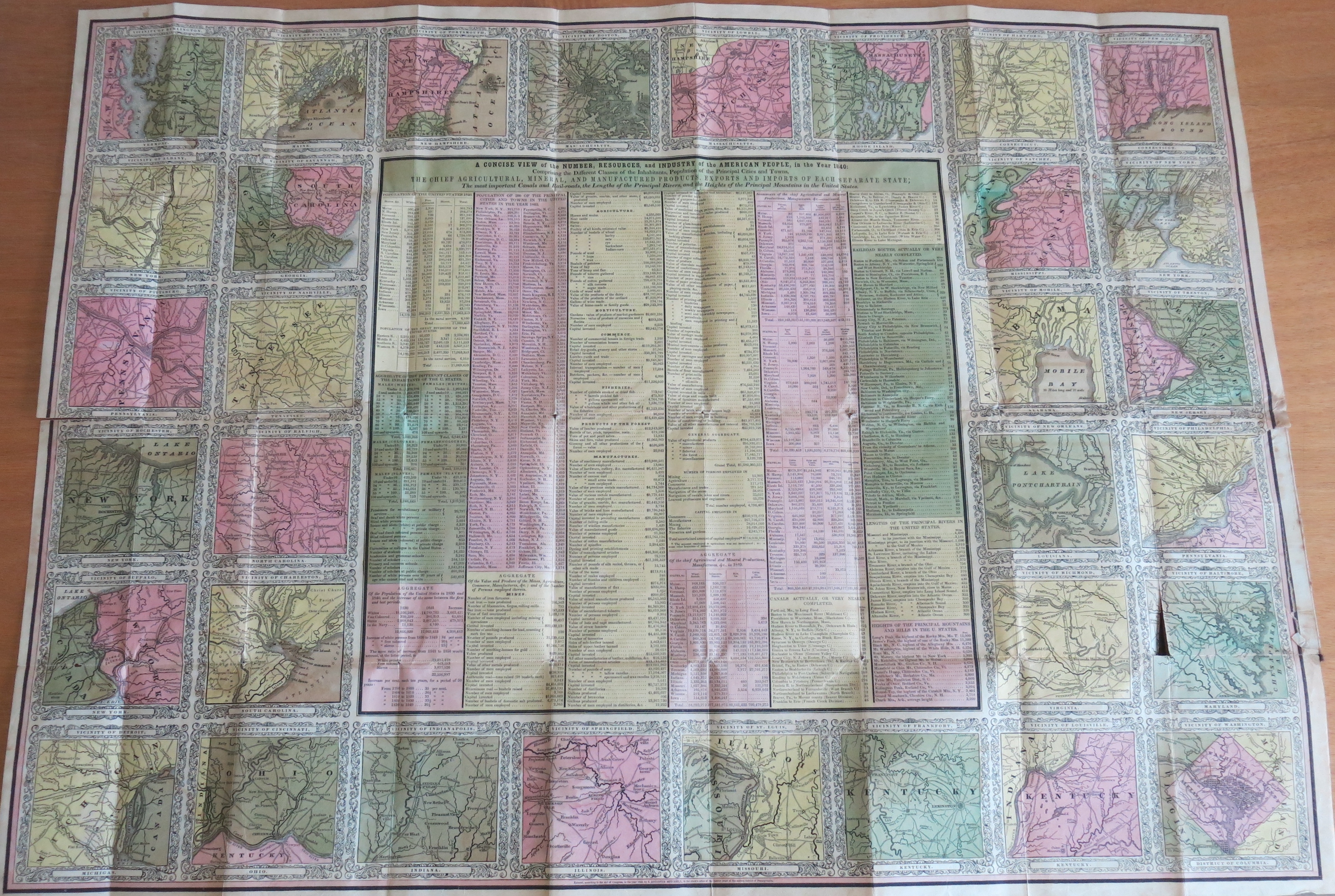
1843 MITCHELL'S NATIONAL MAP OF THE AMERICAN REPUBLIC OR UNITED STATES OF NORTH AMERICA TOGETHER WITH MAPS OF THE VICINITIES OF THIRTY-TWO OF THE PRINCIPAL CITIES AND TOWNS IN THE UNION. Published by S. Augustus Mitchell, Philadelphia 1843. Drawn by J.H. Young. Engraved by J.H. Brightly. This pocket map folds into a 7.5 x 4 inch black hard cover with the title MITCHELL'S NATIONAL MAP OF THE UNITED STATES. An unusual feature of this cover is a clasp. The states are shown to the eastern edge of Texas. Maine and Florida are cut off with insets of northern Maine and south Florida. There are three populaton tables at the right. This map is folded and attach to the front cover with a blank verso. Attached to the back cover is a folded sheet of the same size (and blank verso) with 3 x 3 inch maps of the 32 cities and towns, with a map of Philadelphia for Pennsylvania, and a number of mostly economic information tables in the center. The large double maps makes this one of the most elaborate pocket maps seen. Longitude from Washington. Scale: 1 inch = 45 miles (main map). Size: 25 x 34.5 inches. |
|
|
1846 MAP OF PENNSYLVANIA, NEW JERSEY AND DELAWARE Compiled from the latest authorities. Philadelphia Published by S. Augustus Mitchell. 1846 Sold by Thomas, Cowperthwait & Co. No. 253 Market Street. The title on the black 5.25 x 3.25 inch cardboard cover is similar. The map contains four insets at the bottom arranged to keep Maryland from showing: Vicinity of Pittsburg, Lehigh and Schuylkill Coal Regions, Vicinity of Philadelphia, and Vicinity of Lancaster. There is a scroll border around the edge and standard (though heavy) type paper is used. In this copy, the map is now detached from the cover, but in reasonable shape. The inside cover contains population data from the 1840 census. Although the title does not say, this is believed to have been printed strictly as a pocket map as the emphasis is on travel with many roads, railroads, and canals shown, and an 'explanation' for same in the lower right corner. Blank verso, longitude from Washington at bottom, from Greenwich at top. Scale: 1 inch = 18 miles. Size: 18.75 x 23 inches. |
|
|
1847 MAP OF THE CIRCUIT OF TEN MILES AROUND THE CITY OF PHILADELPHIA : WITH THE NAMES OF VILLAGES, ROADS, MILLS, PROPERTY OWNERS, TAVERNS &C. From original surveys by J.C. Sidney, C.E.; Delaware Co. By Dr. Ash; Robert P. Smith, Publisher, 144 Chestnut Street, Philadelphia. 1847. Engraved by N. Friend. As Friend is named as the engraver, this map may have come from P. Duval s lithograph shop. The ten miles includes parts of adjoining counties and a part of New Jersey. Views of Girard College and Laurel Hill Cemetery are at bottom. This appears to be a relatively rare map, the Free Library of Philadelphia has a copy; also see Phillips, p. 705. According to text on the inside cover, Sidney was Assistant Librarian at the Philadelphia Library. The map folds into a 5.5 x 3.5 inch brown hardback cover with the cover name Sidney s Map of Ten Miles around Philadelphia. Blank verso, linen backed. Lithograph. Scale: 1 inch = 1 mile. Size: 20.5 x 21 inches. |
|
|
1848 TOURIST S POCKET MAP OF PENNSYLVANIA EXHIBITING ITS INTERNAL IMPROVEMENTS ROADS DISTANCES &C. By J. H. Young Philadelphia. Published by S. Augustus Mitchell 1848. Entered according to Act of Congress April 1831 by S. Augustus Mitchell. Sold by Thomas, Cowperthwait & Co. No. 253 Market Street. This is a later editon of the 1831 map above and almost identical to the 1843 map above. It folds into a 5 x 3 inch reddish cover titled Mitchell s Map of Pennsylvania , with county populations listed on the inside. It is printed on vellum paper and has insets of Philadelphia and the Lehigh and Schuylkill Coal Regions, and an elevation map of the Pennsylvania Canal across the top. The upper right corner of the cover has been chewed by mice which has resulted in two half-inch holes in the map in Lycoming and Venango counties. Otherwise, the map is in good condition. Blank verso, longitude from Washington at top, from Greenwich at bottm. Scale: 1 inch = 23 miles. Size: 12.5 x 15 inches. |
|
|
1849 PHELPS'S NATIONAL MAP OF THE UNITED STATES, A TRAVELLER'S GUIDE. Published by Ensign & Thayer, 50 Ann Street, New York 1849. Drawn & Engraved by J.M. Atwood, N.Y. This map covers the eastern United States to just beyond the Mississippi with a cutoff southern Florida and northern Maine. Southern Florida is included at bottom in a reduced scale inset. There is also an inset at bottom right of the western United States. Roads, railroads, and canals are shown and many towns. Images of national figures, mostly presidents, and state seals surround the map. This pocket map folds into a red hard cover with the title Phelps's Traveller's Guide Through the United States; which was published (almost?) yearly for many years. This pocket size booklet contained information for travelers of the time. It appears to be a lithograph, blank verso, longitude from Washington. Scale: 1 inch = 72 miles. Size: 20 x 25 inches. |
|
|
1852 TOWNSHIP MAP OF PENNSYLVANIA, Published by Horace Thayer & Co., 50 Ann St., New York and 127 Main Street, Buffalo. This map folds into a 5.5 x 3.5 inch redish embossed case with the title Horace Thayer & Co. s Map of Pennsylvania . The map is attached to the back cover, on the inside of the front cover is a list of other maps for sale by Thayer, Bridgman & Fanning, 156 William St. (corner of Ann) New York, apparently their retail establishment. The map is entered according to Act of Congress in the year 1852..., and has 1850 census data. Townships are shown, but not differently colored. Rail lines and canals are shown, but not roads. The rail line west to Pittsburgh is shown as complete. Printed on onionskin paper with a fancy scroll border, and this copy is in good condition. Blank verso, longitude from Washington. Scale: 1 inch = 13 miles. Size: 20 x 26.5 inches. |
|
|
1854 PENNSYLVANIA. Published by J. H. Colton, No. 36 Cedar St., New York, 1854. Entered according to Act of Congress in the year 1853 by J. H. Colton etc. This map on vellum type paper folds into a 5 x 3.5 inch black cover titled Map of Pennsylvania - J. H. Colton.' On the inside cover is a Colton ad with a list of maps published, and a portion of a county census on the verso of the map can be seen. Roads, railroads, and canals are shown. The scroll border used on Colton atlas maps is also on this one and it was likely printed from an atlas plate. This copy is in very good shape. Blank verso, longitude from Washington at bottom, from Greenwich at top. Scale: 1 inch = 22 miles. Size: 12.5 x 15.5 inches. |
|
|
1855 A NEW COUNTY MAP OF THE STATE OF PENNSYLVANIA AND ADJOINING STATES, Showing the Route of the Central & Other Rail Roads &c &c. Reduced from the large state map by J. W. Otley, Published by R. L. Barnes, N. E. Corner 7th & Market Streets, Philadelphia 1855. Engraved on stone by Friend & Aub, 80 Walnut St. 2nd door below 4th Philada. Entered according to Act of Congress in the year 1852 by R. L. Barnes. This map is a later edition of the original 1852 version, and Barnes seems to have published this map yearly, as least for a while. It folds into a 6 x 4 inch green cover with the title Barnes s Map of Pennsylvania . The inside cover is blank. The main rail lines are indicated in red and other lines in black. There is a statistics table at lower left. The map is printed on onionskin paper, but still has signs of wear and tear. New Jersey is shown in toto and Delaware almost. Blank verso, longitude from Washington. Scale: 1 inch = 10 miles. Size: 25.5 x 36 inches. |
|
|
1855 PLAN OF THE CONSOLIDATED CITY OF PHILADELPHIA. Published by J.D. Scott, 116 Chestnut St., Philadelphia. Printed by Wagner & McGuigan, No. 4, Franklin Place, Philadelphia. This pocket map is folded into a 5.5 x 3.5 inch hardback brown cover with the title Scott s Map of Philadelphia. It is undated, but the city was merged with the county in 1854, so this map was likely printed shortly after. In fact, it may vie with the 1855 Barnes map (see Early County Map List) as the first one printed of the new larger city. City districts are indicated by hand color and numbered and the map is surrounded by a decorative border. The map is printed on ordinary paper and this copy has separated along the fold lines into several pieces and needs to be backed; an indication there may not be many of these around. Lithograph, blank verso. Scale:1 inch ~ 6 blocks. Size: 25.5 x 24 inches. |
|
|
1856 MAP OF MCKEAN COUNTY PENNSYLVANIA 1856. Drawn in the office of W. K. King, Smethport, Pa. Engravd & printd at A. Kollner s Lithy, Phila. Smethport is the county seat of McKean County. This map is attached to, and folds into a 7 x 4 inch brown embossed cover which is unmarked. The inside cover contains handwritten notes saying the map once belonged to King s daughter. The land is sectioned and numbered and some of the owners noted, and the townships are color coded. Shippen Township on the map was incorporated into Cameron County formed in 1860. This map precedes the Pennsylvania oil field discoveries of 1859, and so is unrelated to oil leases. The ordinary paper is delicate and there is a long tear on one fold in this copy. This map was also issued as a linen-backed wall map. Blank verso, no longitude marked. Scale: 1 inch = 2 miles. Size: 26 x 24 inches. |
|
|
1861 RAILROAD & TOWNSHIP MAP OF THE STATE OF PENNSYLVANIA. Published by R. L. Barnes, 27 South 6th Street, Philadelphia 1861. This map also shows roads in thin double line. It is notable for the fancy scroll work around the edge and the small pieces of yellow paper with population pasted over each county to update the map with the latest 1860 census. It folds into a 6 x 4 inch brown hardback cover with title Barnes s Township & Railway Map of Pennsylvania. The map is attached to the back cover at the center top, so it unfolds both ways. The inside cover has some ownership notes, one an autograph. In this copy, the front cover is loose and the spine is gone. The map is printed on ordinary paper and quite fragile with age. Blank verso, longitude from Washington. Scale: 1 inch = 7.25 miles. Size: 28 x 42 inches. |
|
|
1863 RAILROAD MAP MIDDLE STATES INCLUDING NEW YORK, NEW JERSEY, PENNSYLVANIA, DELAWARE, MARYLAND, OHIO AND CANADA. G. Woolworth Colton s Series of Railroad Maps, No. 3. Drawn, engraved, and published by G. Woolworth Colton, 18 Beekman St., New York. 1863. This map also includes western New England and the Connecticut river valley. Insets of New York and Philadelphia are at bottom. The map folds into a red hardback cover with the title G. Woolworth Colton s County & Distance Railroad Map. Rail lines are named and station stops shown. There is a fancy scroll border typical of Colton maps. Lithograph, longitude from Washington at bottom, from Greenwich at top. Blank verso. Scale: 1 inch = 20 miles. Size: 27 x 36 inches. |
|
|
1865 MAP OF FORREST COUNTY, PENNSYLVANIA. Published by R. L. Barnes, No. 27 Sth. Sixth St., Philadelphia. This pocket map folds into a 6 x 3.75 inch black cardboard cover with the correctly spelled Forest County on the front. On the inside cover is the title County Maps of the State of Pennsylvania, embracing the Oil District.. ; and the county maps listed for sale are: Venango, Forest (this map), Elk, Warren, Greene, and Clarion; and also a general map embracing all the counties west of the Allegheny Mountains. In small type is W. F. Geddes, Printer, 320 Chestnut St. This map is undated and not listed in county map sources. It must date between the oil discoveries of 1859 and Barnes departure from the business (taken over by J. L. Smith) in 1867. The boundaries shown for the county are those which existed between 1850 and 1866 (per Long), and the listed map of Warren County is probably #808 in Stephenson dated 1865. Also, a Venango County map by Barnes was seen also dated 1865, which is probably the one listed. So, a date of 1865 is used here. The numbered blocks are probably oil leases. The only town shown is Marion, now Marionville, and the county seat when the county was first formed, which later moved to Tionesta. Blank verso. Scale: 1 inch = 1.5 miles. Size: 18.75 x 15.25 inches. |
|
|
1866 COLTON S NEW TOWNSHIP MAP OF THE STATE OF PENNSYLVANIA. Published by G.W. & C.B. Colton & Co. New York, 1866. This map folds into a 6 x 4 inch black hardboard cover with an abbreviated title.The inside cover has ads for other Colton items. This is a pocket version of an atlas map printed on onionskin paper, and was issued on and off from the 1860s into the 1880s. It is notable for the detail in which the state is shown, with the hand color coding extending to the township level. This particular copy has small tears at some fold corners, but is in decent shape. Blank verso, longitude from Washington at bottom, from Greenwich at top. Scale: 1 inch = 12 miles. Size: 18 x 26.5 inches. |
|
|
1868 BARNES TOWNSHIP MAP OF PENNSYLVANIA. S. B. Linton, Lithographer, No. 517 Prune St., Philda. Published by R. L. Barnes, No. 27 S. Sixth Street, Philadelphia. This large attractive map goes into a hardback brown cover labeled Barnes Map of Pennsylvania in Townships. An extensive road network is shown as well as rail lines, and a green ruler trim runs around the edge. Townships are color coded apparently by hand, which must have been a tedious job even with stencils. The map is printed on heavy paper. This copy is missing a small piece on the left side and has been extensively repaired on the back with tape. It is loose from the cover which is blank inside. It was likely one of the last projects overseen by Barnes who turned his business over to J. L. Smith circa 1867-68. Blank verso, longitude from Washington. Scale: 1 inch = 7 miles. Size: 28.5 x 45 inches. |
|
|
1870 BARNES S RAILROAD, CANAL & COUNTY MAP OF PENNSYLVANIA NEW JERSEY & ADJOINING STATES. Published by John L. Smith No. 27 Sth . 6th St. Philadelphia 1870. Entered according to Act of Congress in the year 1864 by R. L. Barnes.. . This map is backed with linen and folds into a 6 x 4.25 inch brown cardboard cover with the title "Barnes Map of Pennsylvania in Townships." Why this cover title was used is a mystery since the townships are not identified let alone color coded as on the 1866 Colton map above. On the inside cover is the 1860 county populations and the note: Sheble, Smith & Co. (successors to R. L. Barnes). Roads are shown by light line and railroads by darker line. There is an unusual piano key border all round. This is quite a large map and is linen backed, the size would indicate it never appeared as an atlas map. In this copy the map is in good condition, but the cover is split in two. Blank verso, longitude from Washington. Scale: 1 inch = 11 miles. Size: 25 x 36 inches. |
|
|
1871 RAILWAY MAP OF PENNSYLVANIA, Published by Callender & Co. Philadelphia. Entered according to Act of Congress in the year 1871 by the National Railway Publication Company.. . This unusual pocket map is from a relatively obscure publisher. Rail lines are shown in red over-printing with all stops printed, and probably only passenger lines are shown as there were more lines at this late a date. Counties are shown and topography by hachures. Advertising text at upper right offers other maps of Philadelphia by the company, including a wall map for $1.50, and a city guide with map and directory for 25 cents. This would indicate that this map was made as a pocket map only, otherwise a source atlas would also be listed for sale. The map is on ordinary paper and folds into an embossed, gilt-stamped, and now faded, 5.75 x 3.75 inch purple cover. The inside cover is blank. Blank verso, no longitude given. Scale: 1 inch = 16 miles. Size: 13 x 19.5 inches. |
|
|
1872 COLTON"S TRAVELERS' MAP OF THE UNITED STATES, SHOWING THE COUNTIES, RAILROADS, &C, G.W. & C.B. Colton & Co. This pocket map shows the United States from Maine down to the panhandle of Florida, and west to Dakota and Texas. It folds into a brown 6 x 4 inch hardcover folder with embossed gilt lettering. Onionskin paper is used for the map. The inside cover has ads for other Colton products. Blank verso, longitude from Greenwich at top, from Washington at bottom. Scale: 1 inch = 52 miles. Size: 26 x 29.5 inches. |
|
|
1872 PHILADELPHIA AND ITS ENVIRONS. Complete ward map of the city of Philadelphia giving the locations of all the public places.... and the principal rail roads. Philadelphia: Schaefer & Koradi, Southwest cor. Fourth & Wood streets. This title is printed in both English and German on the 6.5 x 5 inch brown hard cover of this pocket map. The title on the map itself is 'New and Improved Map of the City of Philadelphia transferred from the latest official surveys and information from the various departments of the city' by E. Stotfier, Civil Engineer. Published by T.R. Callender & Co., 3rd & Walnut Sts. Phila. H.J. Toudy & Co. Steam Lith. Phila. Entered according to Act of Congress in the year 1872 by T.R. Callendar...; all printed only in English. Two illustrations titled 'International Exhibition-Main Building', and 'Art Gallery-International Exhibition' (which probably occurred in 1876) have been stamped in blue over the older map, as well as the name 'John P. Hunt'. The map has been trimmed from a larger size to its present dimensions with no margins. This unusual item, with a number of individuals named is probably best explained as follows. In 1872 Callendar commissioned the civil engineer to prepared the map and had it printed by Toudy and sold it. Sometime circa 1876 Hunt stamped the International Exhibition illustrations on it and it was resold by Schaefer & Koradi, a vendor who had a German clientele. There are insets of scenes along the right and lower left. This copy has separation along fold lines, one panel completely separated, but is all there. Lithograph, with ads on the verso. Scale:1 inch~3 blocks. Size: 34 x 27 inches. |
Copyright
2011 by Harold Cramer. All rights reserved.
Revised February, 2014; October, 2018; January, 2019; October, 2021; January, 2024.