In 1810 the county of Ontario
was created, its name was changed to Bradford County in 1812 with
the county seat at Towanda. Susquehanna County was also created
in 1810 with the seat at Montrose. Additional counties created in
this decade were: Schuylkill (seat at Orwigsburg then Pottsville)
in 1811, Lehigh (Allentown) in 1812, Columbia (Bloomsburg),
Lebanon (Lebanon), and Union (Lewisburg) in 1813, and finally
Pike County (Milford) in 1814. There were now an even 50 counties.
 |
1810.1
UNITED STATES OF AMERICA NORTHERN PART, from Pinkerton's
Modern Atlas, London published 18 April 1810 by
Cadell & Davies Strand & Longman Hurst Rees &
Orme Pater Noster Row, drawn under the direction of Mr.
Pinkerton by J. Herbert, Neele Sculp. 352 Strand. John
Pinkerton was an English cartographer who died in 1826 (Lister).
This large map covers the east from Maine to Virginia and
includes southern Canada and Ohio, however only the
Pennsylvania region is shown here. The map is attractive
but not very accurate. The mountains are misplaced, the
Erie triangle is missing, and the northeast boundary is
incorrect. The atlas was also published in 1815 (Lister),
with an American edition by T. Dobson, Philadelphia in
1818, see Phillips page 879. There is a companion 'southern
part' map. Longitude west from Greenwich. Blank verso.
Scale: 1 inch = 33 miles. Size: 20 x 27 inches. |
 |
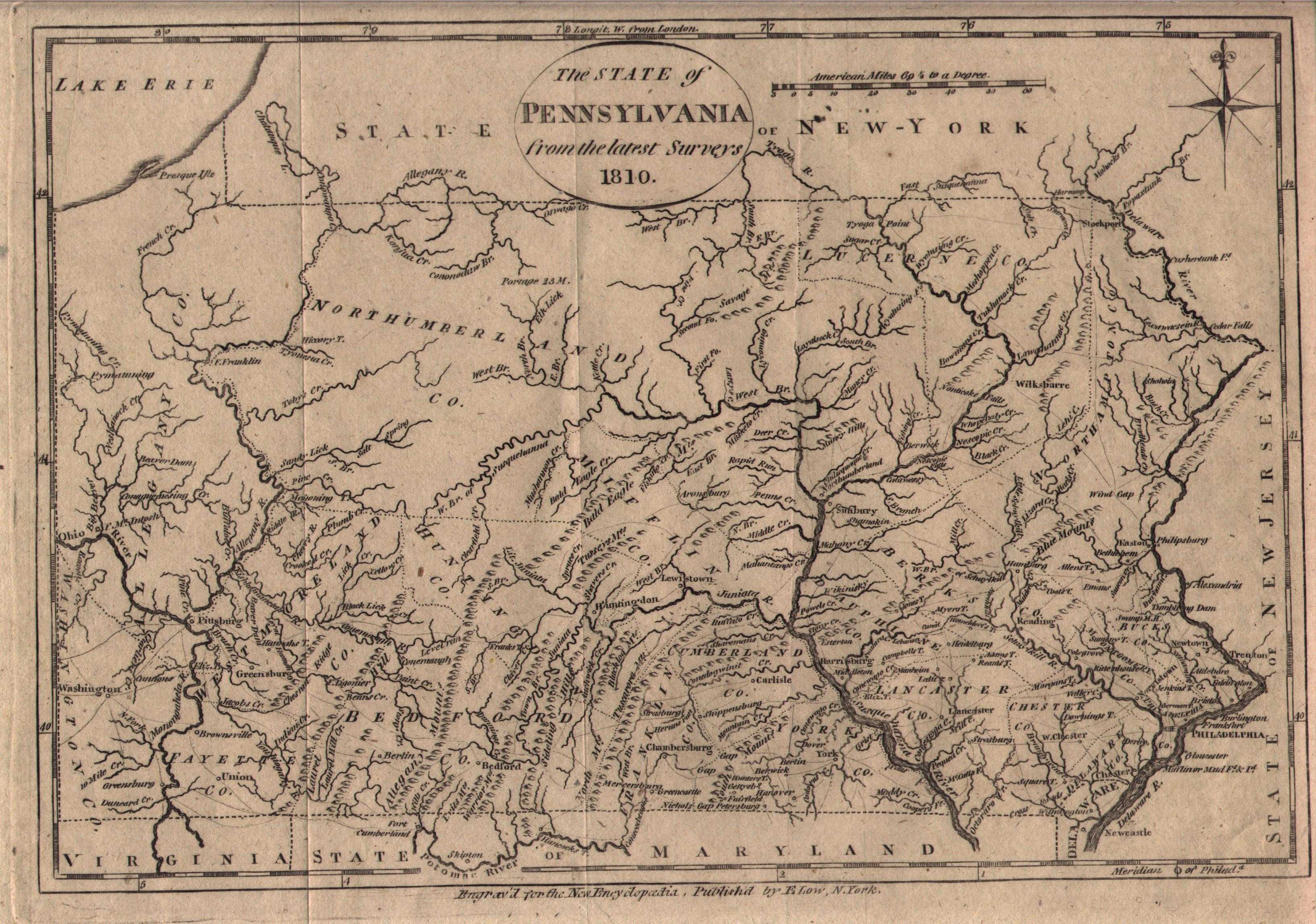
1810.2
THE STATE OF PENNSYLVANIA FROM THE LATEST SURVEYS 1810. Engraved for The New and Complete American Encyclopaedia, Published by E. Low, N. York 1808. Except for the change in date, this map is identical to map 1800.1. The publication date of 1808 is earlier than the date on the map, This is also the case for the 1800 map apparently published circa 1798-99. Publication of the Encyclopedia began in 1805 by John Low and completed with Volume 7 by E. Low in 1811. This map appeared in Volume 6 in 1810. Longitude west from London at top, from Philadelphia at bottom, blank verso. Scale: 1 inch = 32 miles. Size: 7.25 x 10.5 inches. |
 |
1810.3
UNITED STATES OF AMERICA, T. Clerk, Sculp. Lister says Thomas Clerk flourished circa 1811-35 and worked for John Thompson & Co. This map has been seen dated circa 1810 and that date is used here; however, Ohio is not identified as a state while Kentucky and Tennessee are, which would date it circa 1796-1803. The east coast is shown from Maine to include all of Florida and west to the Mississippi. Georgia extends west to the Mississippi, Florida is divided into east and west. The map appears to have been bound at the right edge and top right and tri-folded, so probably from a book and not an atlas. Longitude west from Greenwich, blank verso. Scale: 1 inch = 175 miles. Size: 9.25 x 7.5 inches. |
 |
1810.4
KARTA OVER VINGANDACOA ELLER FORENTA STATERNE I NORDAMIERICA. Ae Daniel Djurberg Rector Schola Ledamot of Cosmograf Salsk i Upsala Stockholm 1810. (Map Vingandacoa or the United States in North America). This map comes from a composite atlas from Djurberg and Akerman, two Swedish mapmakers of the 18th and 19th century. It shows the eastern United States west to almost the Rocky Mountains and shows a boundary line that is probably meant to delineate the Louisiana Purchase. Pennsylvania is shown with the Erie triangle and Ohio (1803) is shown as a state. The small New England states are marked with a letter and a corresponding legend. The strange name for the United States has not been seen before and apparently is unique to Sweden at this time. Intaglio print. Longitude apparently east of Ferro, blank verso. Scale: 1 inch = 206 miles. Size: 8.5 x 11 inches. |
 |
1810.5
AMERICA UNITED STATES. No. 29 J. Morrison, 21 Bridge St. Glasgow. On this map of the eastern United States, Ohio (1803) seems to be shown as a state while Louisiana (1812) is not; so it is dated circa 1810 here. The numbering would indicate the map comes from a British (or Scottish) atlas. It is not well drawn, with Maine cut off and irregular borders on the other states. Pennsylvania is shown without the Erie triangle. Georgia and Florida extend to the Mississippi River. There is a fancy border and the map is hand colored. Blank verso, intaglio print. Longitude west of Greenwich. Scale: 1 inch = 250 miles. Size: 8 x 10.5 inches. |
 |
1811.1
A MAP OF THE STATE OF PENNSYLVANIA BY READING HOWELL
MDCCCXI, engraved by J. Vallance, Philada., published by
Kimber & Conrad & Johnson & Warner. Howell
issued this updated version of his smaller 1792 and 1795
maps in a larger size. The
northeast
showing the elusive county of
Ontario and part of the
southwest
are shown here. The topography
is precisely drawn, as are roads, towns, and important
buildings. The northeast view has been enlarged to show
the detail in Howell's map. The dedication cartouche has
an agricultural motif. In the lower right the title
cartouche is surrounded by a vignette illustrating
different aspects of the state and including the state
crest. In the lower left is a drawing of the Schuylkill
Permanent Bridge, no longer standing in 1811. See
Phillips page 680. Longitude from Philadelphia. Blank
verso. Scale: 1 inch = 10 miles. Size: 21 x 34 inches. |
 |
1811.2
CARTE DES ETATS-UNIS par Fx Delamarche fils 1811. A copper engraved map believed to be from Nouvel Atlas Portatif, destin principalement pour l'instruction de la jeunesse; by Robert de Vaugongy & C. F. Delamarche. Paris - Delamarche & Dien - circa 1810-1820. The map shows the east coast from Nova Scotia to Florida and west to the Mississippi. Cuba and northern Yucatan are included along the bottom edge. A table at right lists the states identified by number on the map. State boundaries are crudely and inaccurately indicated by dots and the map is based upon old information for its time, likely directly copied from an old map. Felix Delamarche fils was the son of Charles Francois Delamarche 1740-1817. Longitude west from Paris, 43 stamped on the verso. Scale: 1 inch = 180 miles. Size: 11.5 x 11 inches. |
 |
1811.3
THE UNITED STATES OF AMERICA. Published, Jany 1 1811, by W. Darton Junr, Holborn Hill. Like the map above, this one looks ten years older than the published date. The map extends from Nova Scotia south to include all of Florida and west to the Mississippi. Pennsylvania is shown with modern boundaries and numerous towns are named; however, Ohio is not recognized as a state. Blank verso, longitude west from Greenwich. Scale: 1 inch = 175 miles. Size: 11 x 9.5 inches. |
 |
1811.4
UNITED STATES OF NORTH AMERICA. Published Jany. 1, 1811, by Sherwood, Neely & Jones No. 20, Paternoster Row, London. Alexr. Macpherson Delt. Cooper Sculp. This map appears to be a later version of the Arrowsmith map 1802.1. Pennsylvania is without the Erie triangle and there is no Ohio; but Tennessee and Kentucky are there. Blank verso, longitude west from London. Scale: 1 inch = 190 miles. Size: 7.5 x 9.75 inches. |
 |
1811.5
STATES OF AMERICA, FROM THE BEFT AUTHORITIES. J. Russell Del et Sculp. Plate xxviii. This map is believed to be from Guthrie s Geography. There are listings of Guthrie s A System of Modern Geography, or a Geographical, Historical and Commercial Grammer with the 6th edition in 1795 and the 7th in 1811. This map is likely from the 1811 edition. It is similar to map 1795.8 of similar title, but is updated with additional names and different title placement. The list of 15 states, Kentucky (1792) but not Tennessee (1796) would indicate the map was originally prepared for the 1795 edition. William Guthrie was long dead, but his book continued to be published. Map 1801.3 has a similar title but is a different map. The United States is shown from Maine to a cutoff Florida and west to the Mississippi, with the area west of that named as various territories and as belonging to numerous Indian tribes. Towns, as well as forts, are named. A twenty leagues line is shown along the eastern seaboard. Pennsylvania has its modern borders and numerous towns are named. Blank verso, longitude west from London. Scale: 1 inch = 200 miles. Size: 7.5 x 9 inches. |
 |
1812.1
A MAP OF THE UNITED STATES AND PART OF LOUISIANA, from Brookes s General Gazetteer Improved; or a new and compendious geographical dictionary, orginally written by R. Brookes, M.D., the second American edition, published by Johnson and Warner, Philadelphia and Richmond 1812. The first American edition was published in 1806 and it also contained this map. The gazetteer is an approximately 500 page (pages unnumbered) geography book with 8 maps: World, North America, South America, Asia, Africa, Europe, West Indies, and this map, which has also been seen credited to early geography books by both Guthrie and Davis. Richard Brookes' book had a long publishing history continuing on after his death. Different sets of maps were included in different versions; a 1796 edition was seen with maps of the continents but no regional ones like this. |
 |
1812.2
THE MIDDLE STATES AND WESTERN TERRITORIES OF THE UNITED STATES INCLUDING THE SEAT OF THE WESTERN WAR - 1812. Like the one above, this map is purportedly from the 1812 edition of Brookes General Gazetteer Improved, Philadelphia & Richmond: Johnson & Warner, 1812; however, the same map was seen at auction as being from William Guthrie, A New Geographical, Historical and Commercial Grammar... 2nd American Ed. Philadelphia: Johnson & Warner, 1815. Another source says the map is from Matthew Carey's A General Atlas, being a collection of maps of the world and quarters, and their principal empires, kingdoms, &c... Philadelphia: Published by M. Carey, and Johnson & Warner 1814. This atlas is a quarto version of Carey's better known folio General Atlas. It is possible this map appeared in all three publications. The mid-Atlantic region is shown from New York to Virginia and west to Illinois. The northern boundaries of Indiana and Illinois territory run below Lake Michigan in this map; they were later moved north. Longitude west from Philadelphia, blank verso. Scale: 1 inch = 130 miles. |
 |
1812.3
VIEW OF THE COUNTRY ROUND PITTSBURG, Drawn by J.
Melish, J. Vallance F.S.A. Sculpt. This small map is from
Travels in the United States of America, in the Years
1806 & 1807, and 1809, 1810 & 1811 by John
Melish. Melish was from Scotland and visited America
several times before settling here in 1811. He made notes
on his visits and published Travels... in 1812
which included the maps that began his cartographic
career.This map covers about 10 miles around Pittsburgh
and is illustrated in Ristow, page 180. Blank verso.
Scale: 1 inch = 0.3 miles. Size: 6.5 x 4 inches. |
 |
1812.4
ETATS UNIS ET GRANDES ANTILLES, Grave' par Chamouin Rue de la Harpe No. 35. Ecrit par Giraldon. This map is believed to be from a Malte-Brun atlas of 1812, probably Atlas complet du pr cis de la G ographie Universelle de M. Malte-Brun : Dress conform ment au texte de cet ouvrage et sous les yeux de l'auteur. Par M. Lapie. Published: Paris : chez Fran ois Buisson, 1812. The page size matches. This map includes the east coast west to beyond the Mississippi; plus Cuba and the Yucatan which makes it a little beyond the usual criterion for inclusion here. The state borders are crudely indicated with hand drawn color lines. Blank verso, longitude from Paris. Scale: 1 inch = 250 miles. Size: 11.75 x 8.75 inches. |
 |
1812.5
CARTE DES PROVINCES SEPTLES. DES ETATS-UNIS. This anonymous and undated map is attributed to Jean-Nicholas Buache circa 1812. It appears to have been originally folded and lacks a plate number, and so may come from a book rather than an atlas. Jean was the nephew of the better known French geographer Philippe Buache who followed Delisle. Philippe is perhaps best known for drawing a mysterious 1737 map showing Antarctica with some accuracy. The coverage in the map here is from lower Maine south to include most of Delaware and west to include all of Pennsylvania. Counties (called provinces) are shown and the map dates circa 1790 based on counties shown; i.e. Allegheny County is named. The Erie triangle is shown dating the map after 1792. There is likely a companion map showing the southern states. Intaglio print (possibly a steel engraving), blank verso. Longitude west from Ferro at bottom, west from Paris at top. Scale:1 inch = 38 miles. Size: 12.5 x 19.75 inches. |
 |
1812.6
THE UNITED STATES OF AMERICA CONFIRMED BY TREATY 1783. B. Smith, sc. Published Feb 10, 1812 by R. Wilkinson, No. 58. Cornhill, London. This map shows the eastern United States with Florida cut off, and extends west to the Mississippi. Lake Superior and south Louisiana extend beyond the top and bottom neat lines. Ohio (1803) is not shown as a state and the land west of Pennsylvania and north of Kentucky is called Western Territory. A table of state foundation dates is at lower right. The map probably comes from an edition of Wilkinson s Generl Atlas, first published in 1809. Blank verso. Intaglio print. Longitude west from Greenwich. Scale: 1 inch = 140 miles. Size: 8.5 x 11 inches. |
 |
1813.1
TOWN OF PLAINFIELD. This manuscript map in a very good
hand shows a plan view of Plainfield, Northampton County.
The original town plan is annotated in a different hand
and bears the date 1813 on the verso on an attached (with
paste) slip of paper at the bottom. It is not clear if
the attachment was made for the note or to enlarge the
sheet for the drawing. The names given are all
landholders, no author identified. The town is still
there, population 376 in 1990. The manuscript was
originally folded. Size: 13 x 15 inches. |
 |
1813.2
UNITED STATES OF AMERICA, London, Published by S. A. Oddy, No. 20 Warwick Lane. Engraved by Jas. Wallis. This map is believed to come from A General Atlas of the World : containing distinct maps of all the principal empires, states, kingdoms, and principalities, throughout the world. Engraved and carefully selected from the most approved authorities by James Wallis. London: Published by S. A. Oddy 1813. There were apparently two versions of this atlas, one published by Wallis and one by Oddy. The map shows the east coast including all of Florida, but Ohio is not named. Blank verso, longitude west from London. Scale: 1 inch = 175 miles. Size: 10.5 x 8.5 inches.
|
 |
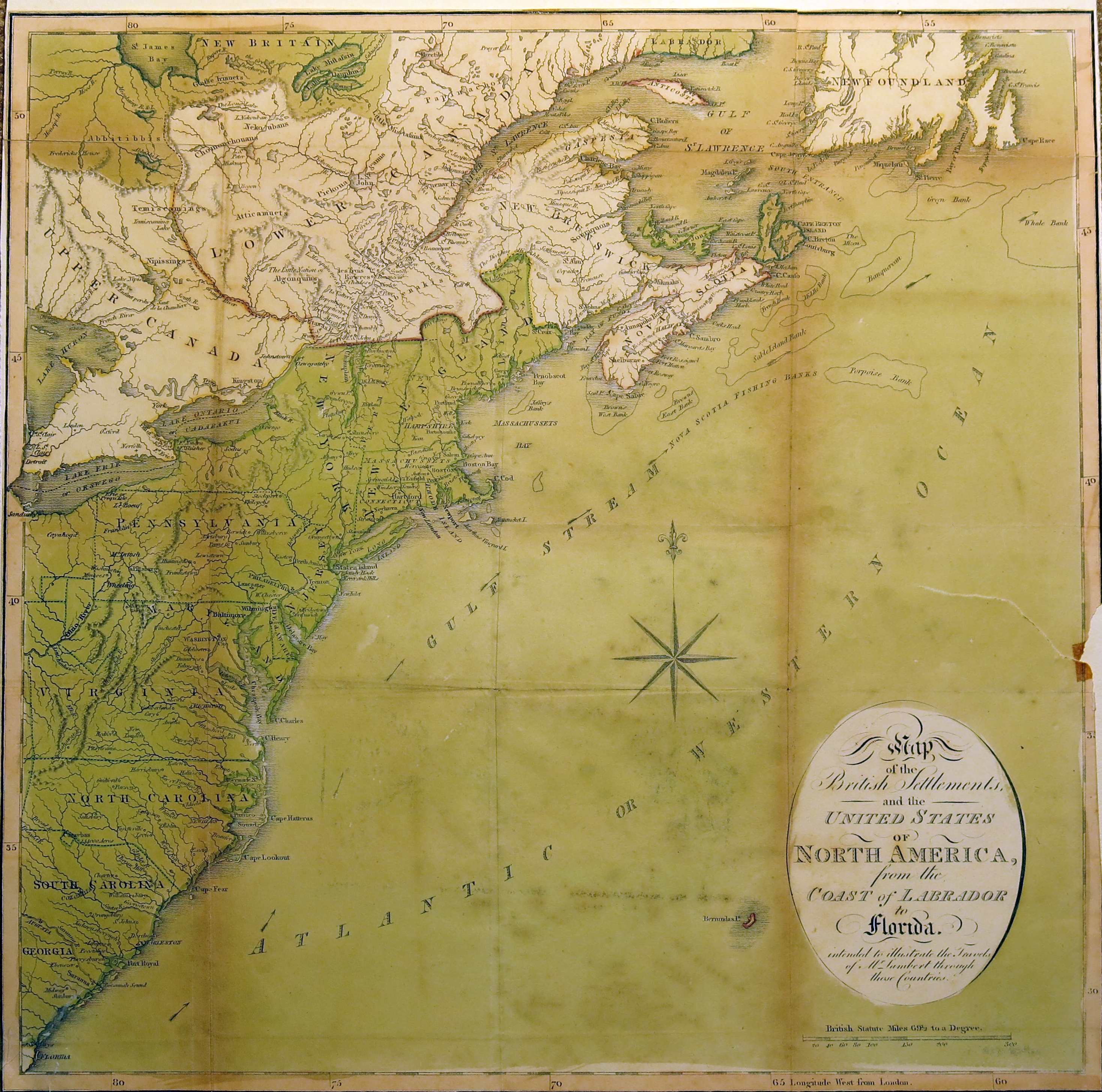
1813.3
MAP OF THE BRITISH SETTLEMENTS, AND THE UNITED STATES OF NORTH AMERICA, FROM THE COAST OF LABRADOR TO FLORIDA. INTENDED TO ILLUSTRATE THE TRAVELS OF MR. LAMBERT THROUGH THOSE COUNTRIES. London: Published Octr. 25, 1813 by Cradock & Joy, Paternoster Row. From a book by John Lambert, this map depicts the region from Lake Huron to Newfoundland and the Atlantic Ocean and from Labrador and St. James Bay to Florida. Cities and towns throughout the region are labeled. Quebec, les Trois Rivi res, and Montreal are among the sites labeled along the St. Lawrence River in Canada, while each of the original thirteen colonies is illustrated and labeled although the borders are not accurate; Pennsylvania lacks the Erie triangle. Cities such as Boston, Hartford, Newport, Philadelphia, and New York are all labeled. Washington City is also present, as the U.S. Federal government occupied the new national capital in 1800. About two-thirds of the map is the Atlantic Ocean, enough to include Bermuda. This map was published by Cradock and Joy in the 1814 second edition of John Lambert's Travels through Canada and the United States of America, in the years 1806, 1807, and 1808. Originally folded, hand color intaglio print. Blank verso, longitude west from London. Scale:1 inch = 100 miles. Size: 15.25 x 15.25 inches.
|
 |
1814.1
PENNSYLVANIA, Plate 14 from Mathew Carey's General
Atlas, Philadelphia 1814. The map can be dated 1804-10
by the counties shown. Most of the map can be seen in
this image. This attractive map shows mountains, rivers,
and roads clearly. Editions of this atlas appeared in
1796, 1802, 1814, 1817, 1818 per Lister. Listed on page
680 of Phillips with an atlas date of 1818. Longitude
from Philadelphia at bottom, west from London at top.
Blank verso. Scale: 1 inch = 14 miles. Size: 11.5 x 18
inches. |
 |
1814.2
MAP OF THE UNITED STATES OF AMERICA. Gridley, sc. Plate 5 from Mathew Carey s General Atlas, Philadelphia, 1814; and the same map appeared in the 1818 edition. This map comes from the same atlas as the one above. The eastern United States is shown to just beyond the Mississippi River and with a cutoff Florida. The mid-western territories are misaligned with the northern boundaries of Ohio, Indiana and Illinois on the same latitude, and Indiana directly below Lake Michigan. The boundary between Mississippi Territory and Georgia follows the Chattahoochee River and west of the Mississippi River is a large Missouri Territory stretching northwards from Louisiana. Major roads with distances, proposed canals, cities, forts, and Indian villages are among the details illustrated. A notation of "Yazoo Speculation" in Mississippi refers to the Yazoo Land Fraud perpetrated in 1789-1796 when the region was part of Georgia Territory. Three companies bribed and forced a bill through the Georgia assembly that allowed them to purchase millions of acres of land for next to nothing, resulting in a huge public outcry. The bill's supporters were swiftly voted out of power, and the law was rescinded in 1796. The fact it is shown on a map produced many years later attests to the importance attributed to this fraudulent scheme. Longitude west from London at top, from Washington at bottom. Scale: 1 inch = 95 miles. Size: 12.75 x 17 inches./td>
|
 |
1814.3
PENNSYLVANIA, W. Barker, Sculp., from Carey s American Pocket Atlas, Mathew Carey, Philadelphia. This map is identical to map 1801.1, although this copy has later added color. It is likely the same map was used in all editions of the atlas after 1801. Streams are shown in considerable detail along with main roads of the time and a few towns. See the United States map below. Blank verso, longitude west from London at top, from Philadelphia at bottom. Scale: 1 inch = 15 miles. Size: 5.75 x 7.75 inches. |
 |
1814.4
UNITED STATES. A map from Carey's American Pocket Atlas; containing twenty maps, viz... . Fourth Edition, Greatly Improved and Enlarged. Philadelphia: Published by Mathew Carey, No. 121, Chestnut Street. 1814. This map shows the country west to the Mississippi with Florida cut off. The atlas was a 170 page book with no illustrations, the Pennsylvania map above and this map of the United States were two of the twenty maps. The other eighteen covered the remaining states and territories of the time. The atlas resembled geography books of the period with short descriptions of the states and countries. This same map was also seen in an 1816 edition of Mason Weems Life of Washington published by Carey. Blank verso, longitude west from London at top and from Philadelphia at bottom. Scale: 1 inch = 175 miles. Size: 8.5 x 9 inches. |
 |
1815.1
THE EASTERN STATES WITH
PART OF CANADA. The date of this map is uncertain, but it
is believed to come from the William Guthrie geography
book A new geographical, historical and commercial
grammar... 2nd American edition, Johnson &
Warner, Philadelphia 1815. Guthrie died in 1770 but his
name continued to be used on geographies published up to
c1820 (Lister). The map had a trifold and was bound along
the right edge. It shows most of Pennsylvania and the
region north and east, including New Jersey, New York,
and New England including the 'District of Maine'. Maine
was separated from Massachusetts and became a state in
1820. The map also shows the St. Lawrence River, Lake
Ontario, Lake Erie, and part of Canada. Much of the
cartography is wrong, Cape Cod is mishapen and mountain
chains are incorrectly shown; this map comes from an old
retouched plate. Longitude west from London at top, from
Philadelphia at bottom. Blank verso. Scale: 1 inch = 93
miles. Size: 8 x 9.5 inches. |
 |
1815.2
MAP SHEWING THE OPERATIONS OF THE AMERICAN AND BRITISH ARMIES DURING THE YEARS 1776 AND 1777 IN NEW JERSEY, PENNSYLVANIA, AND DELAWARE. This small undated and anonymous map shows the area from Sandy hook to Wilmington and about 50 miles west. Valley Forge is called "Encampment 1777." Based on the town names (i.e. Doyles Town) and spelling (i.e. shewing) this is an old map and is dated circa 1815 here. It resembles map 1807.1 and was likely made around the same time, possibly for a British history or subsequent edition of Marshall's Life of Washington. Intaglio print, blank verso. Scale:1 inch = 17 miles. Size: 4 x 6.5 inches. |
 |
1815.3
MAP OF THE SEAT OF WAR IN NORTH AMERICA, Second Edition with Additions & Improvements. J. Melish, del. H.S. Tanner, dirext. Published by John Melish, Philadelphia. This map is believed to come from the second edition of Military and Topographical Atlas of the United States, published by Melish in 1815; the first edition came out in 1813. It shows the northeast to Nova Scotia and west to include Ohio. Distances between towns are marked and there is a population legend at the top. Blank verso, longitude from Washington at bottom, from London at top. Scale: 1 inch = 62 miles. Size:15 x 21 inches. |
 |
1816.1
THE BAY AND RIVER OF DELAWARE, engraved for The
American Coast Pilot, face page 166, New York,
published by Edmund M. Blunt, 1816. This map, though
dated 1816, is from the Tenth Edition of The American
Coast Pilot published by Blunt in 1822. It shows the
Delaware River from Philadelphia to the capes with many
locations identified. A small ship with sails heads into
the bay and river with its course charted through the
sandbars with many depth readings. The first edition of The
Pilot was published in 1796 and drew on earlier
works such as Norman's American Pilot, The Atlantic
Neptune, and The English Pilot: The Fourth Book. Nathaniel
Bowditch, who produced the famous American Practical
Navigator, had a long association with Blunt. The
Pilot continued to be published by Blunt's sons
until the 1860s, see Ristow, Chapter 15. Blank verso,
Scale: 1 inch = 13 miles. Size: 7.25 x 8.25 inches. |
 |
1816.2
UNITED STATES OF AMERICA EXHIBITING THE SEAT OF WAR ON THE CANADIAN FRONTIER. FROM 1812. TO 1815. by R. Walker, Edinburgh, published by Edwd. Baines, Leeds, August 5th, 1816. The most likely source of this map is History of the wars of the French Revolution, from the breaking out of the war in 1792, to the restoration of a general peace in 1815; comprehending the civil history of Great Britain and France, during that period, by Edward Baines. In two volumes, embellished with portraits of the most distinguished characters of the age, and illustrated by maps, plans, and charts. Leeds : Edward Baines ; London : Longman & Co., 1818, 20, 23. The map shows the east from Maine to a cutoff Florida, with an inset at lower right titled Chart of Lakes Erie & Ontario on an enlarged scale. State borders are shown by dotted lines but Pennsylvania's northern border is missing. There is another version of this map with a different cartouche and from Neele & Son, Strand London, seen at auction; which was probably the map used in the later London edition. Blank verso. longitude west from Greenwich. Scale: 1 inch = 140 miles. Size: 9.5 x 13.5 inches. |
 |
1816.3
SPECIMEN OF THE COUNTY MAPS TO BE CONSTRUCTED BY VIRTUE OF AN ACT OF THE LEGISLATURE DIRECTING THE FORMATION OF A MAP OF PENNSYLVANIA, by John Melish. The act referred to was passed in March, 1816, and authorized Melish to prepare a new map of Pennsylvania. He subsequently prepared Directions for Constructing the County Maps in terms of the Act of Assembly, which contained this map as an example for the local surveyors. It shows a small portion of Dauphin County around Harrisburg, the Susquehannah' River from Harrisburg to Halifax, and includes examples of mountains, rivers, roads, buildings, etc. This specimen map may also have been published in some copies of A Geographical Description of the United States, published in 1816. The Melish Pennsylvania map was published in 1822. This map is discussed by Ristow on p. 113. To see how well the county surveyors followed Melish's instructions, see the Whiteside maps below. Longitude from Washington, blank verso, originally folded. Scale: 1 inch = 2.5 miles. Size: 8.5 x 6.5 inches. |
 |
1816.4
(The Whiteside Manuscript County Maps, circa 1816 to 1820). To prepare the 1822 Pennsylvania map, deputy surveyors did most of the work and a clerk in the Land Office, the first of whom was John Whiteside, made office copies of these for the Surveyor General before they were sent on to John Melish for his preparation of the state map, so these copies (the originals did not survive) are sometimes called the Whiteside Maps. Four examples of these maps are shown here: Cambria County (at left); Clearfield County; Indiana County; Centre County. All of the Whiteside maps can be seen at the Pennsylvania State Archives website on maps. Also, see the Early County Map List page for more on county maps. |
 |
1816.5
THE UNITED STATES OF AMERICA. Published by Cummings & Hilliard No. 1 Cornhill Boston. Wightman sc. This map shows the eastern United States to beyond the Mississippi with northern Maine and southern Florida cutoff. Indiana (1816) seems to be recognized as a state, but not Illinois (1818); so dated circa 1816. It is from an edition of School Atlas to Cummings' Ancient & Modern Geography. Boston: Published by Cummings and Hilliard. An 1822 edition of this map is shown in the Pennsylvania in Old Geography Books article. Mountains and rivers are indicated and towns named. The map extends beyond the neat line for Louisiana at bottom and for Lake Superior at top. Longitude west from Greenwich, blank verso. Scale: 1 inch = 150 miles. Size: 8.5 x 10.75 inches. |
 |
1816.6
PHILADELPHIA AND ADJACENT COUNTRY, a map from A Geographical Description of the United States, with the contiguous British and Spanish possessions, intended as an accompaniment to Melish's map of these countries. By John Melish. Second Edition. Philadelphia, Published by the author. T.H. Palmer, printer. 1816. The book contains three similar maps of Boston, New York, and Baltimore. An intaglio print with blank verso. Scale: 1 inch ~ 4 miles. Size: 5.5 x 3.25 inches. |
 |
1816.7
UNITED STATES. London: William Darton & Son, 58 Holborn Hill. This map probably comes from Dr Brookes's General Atlas of Modern Geography...with the new discoveries & territorial arrangements, published by William Darton & Son. Undated, but circa 1815, and intended for a juvenile audience per the OCLC listing. Richard Brookes (fl. 1721 1763) was an English physician and author of compilations and translations on medicine, surgery, natural history, and geography. His best known work is his General Gazetteer: or, Compendious Geographical Dictionary. His works went through many editions even after his death. On this map, Mississippi (1817) is shown as a territory, whereas Louisiana (1812) and Indiana (1816) appear to be states. So, dated circa 1816 here and this may be one of the earliest maps to show Indiana as a state. The coverage extends to the Mississippi; Maine is misshapen and Florida is cut off. Intaglio print with hand color. Blank verso, longitude west from Greenwich. Scale:1 inch = 176 miles. Size: 7.5 x 9.5 inches. |
 |
1816.8
NORTHERN SECTION OF THE UNITED STATES INCLUDING CANADA &C. By John Melish 1816. This map extends west to include Ohio whose southern part extends below the neat line; southern Maryland and Delaware are cut off. The upper half depicts Canada though with little detail. A table with population data occupies the center of Ontario. Roads, towns, and major rivers are shown. The bottom right corner has been repaired and has (apparently) the engraver's name 'C.F. Himberg.' State boundaries are hand outlined in green. Intaglio print, blank verso. Longitude from Washington at bottom, from London at top. Scale: 1 inch = 62 miles. Size: 15 x 20.5 inches. |
 |
1817.1
NORTHERN PROVINCES OF THE UNITED STATES, drawn &
engraved for Thomson's A New General Atlas,
Plate No. 56, Hewitt Sc., Grafton Str., est. Tottenham Ct.
Rd. Published by John Thomson & Co. The map includes
the entire
northeast
with an engraving of Niagara
Falls. A companion map shows the
southeast
and both maps include
Pennsylvania
, which is shown with
inaccurate borders on the Erie triangle on the Northern
map, and with no Erie triangle on the Southern map.
Editions of the atlas appeared in 1817, 1821, and 1827 (Lister).
Blank verso. Scale: 1 inch = 35 miles. Size: 26 x 22
inches. |
 |
1817.2
UNITED STATES. Engraved by A. Findlay, Published by Thomas Kelly No. 53 Paternoster Row London. This map is thought to be from A New & Complete System of Universal Geography, by Christopher Kelly, published by Thomas Kelly, London, 1817. Earlier dates of 1814 and 1815 have also been see for this map. Pennsylvania is shown without the Erie triangle, added in 1792, and Ohio (1803) is not shown; so this map is way out of date and based on much earlier maps. It shows towns and settlements, boundaries of states; a large Georgia extends to the Mississippi, a large Western Territory extends from Pennsylvania westward, with Indian tribal lands ,villages, rivers, mountains. Florida is cutoff. There were several maps like this published in the period 1810-20 based upon an Arrowsmith original. Their common distinguishing feature is the bold display of the Appalachian Mountains. Blank verso, longitude west of Greenwich. Scale: 1 inch = 190 miles. Size: 7.5 x 9.75 inches. |
 |
1817.3
PENNSYLVANIA, W. Barker, Sculp. A map from Carey s American Pocket Atlas, Mathew Carey, Philadelphia, and probably from the 1817 edition. The first edition was published in 1796 (map 1796.2), with other editions in 1801 (map 1801.1), 1805, 1813, 1814. This map has more roads added than the earlier examples, especially in northern Pennsylvania, but is otherwise the same. The meridian of Philadelphia is used at the bottom and London at the top. The map is a one sheet print and has "17" written on it, apparently indicating it was map 17 in the atlas. Blank verso. Scale: 1 inch = 15 miles. Size: 5.75 x 7.75 inches. |
 |
1817.4
UNITED STATES OF AMERICA. (WITH) THE COURSE OF THE RIVER ST. LAURENCE, FROM LAKE ONTARIO TO MANICOUAGAN POINT. J. & G. Menzies Sculpt., Edinr. Map No. 55 from the Edinburgh edition of John Thomson's New General Atlas, published Edinburgh, London, Dublin 1817. Two maps are on one sheet. The left side (16 x 9 inches) is a chart of the St. Lawrence River in two parts. The entire course is shown from Lake Ontario to Montreal, Quebec, and on to the mouth. It also shows a portion of Lake Champlain and the Richelieu River. The main map at right (16 x 14.5) is a hand colored map of the United States extending to the Mississippi River. Maine is shown with British boundary claims. Georgia is shown with its western boundary extending all the way to the Mississippi, and Florida is divided into east and west. The huge western territory is bounded by the Ohio River, Canada, and the Mississippi. It includes today's Minnesota, Wisconsin, Michigan, Illinois, Indiana, and Ohio. The map is filled with notations concerning the navigability of rivers and other items of interest. Intaglio print (possibly steel), blank verso, longitude west from Greenwich. Scale: 1 inch = 97 miles. Size: 16 x 24 inches. |
 |
1818.1
UNITED STATES OF AMERICA, compiled from the latest &
best authorities by John Melish, engraved by Saml.
Harrison, entered according to act of Congress 10th July
1818 and published by Murray, Draper, Fairman & Co.
Philadelphia. The map shows the entire eastern United
States west to Texas, only the eastern half is shown here.
It was originally folded and comes from the 1818 edition
of Melish's Travels Through the United States..., originally
published in 1812, page 880 in Phillips. Longitude from
Washington at top, from London at bottom. Blank verso.
Scale: 1 inch = 120 miles. Size: 16 x 19.5 inches. |
 |
1818.2
VEREINIGTE STAATEN IN NORD AMERICA NACH DEN BESTEN H LFSMITTEL VERFAST. Wien by T. Mollo. Lorenz Rieder sc. Tranquillo Mollo was a Viennese engraver and publisher and this map was issued in Vienna (i.e. Wien). The map is believed to date circa 1818; references to Mollo date from this time; but an 1818 publication was not found. A reference was found for the Allgemeiner hand-atlas by Joseph Dirwalt - Wien : Tranquillo Mollo 1824; so this map might come from that source or an earlier edition. It covers the eastern United States from Newfoundland south to include all of Florida and west to beyond the Mississippi. Ohio is named as a state which would date it after 1803. Indiana (1816) and Illinois (1818) are also named but not listed as states in the table under the title. Pennsylvania is shown with modern boundaries although they are crudely indicated by faint dotted line. Blank verso, longitude appears to be east from Ferro. Scale: 1 inch = 160 miles. Size: 12.5 x 17.5 inches. |
 |
1818.3
MAP OF PARTS OF THE UNITED STATES OF NORTH AMERICA, WITH THE TERRITORY OF THE ILLINOIS ON THE OHIO. PARTICULARLY DESIGNED TO ILLUSTRATE BIRKBECK'S JOURNEY. Neele & Son, Sc. 352 Strand. London. Published March 2, 1818 by J. Ridgway Piccadilly. This map has the title outside the neat line along the top. The tip of eastern Pennsylvania is cut off, i.e. Philadelphia is not shown. The map shows the major road network from Pennsylvania and Virginia in the east to Indiana in the west. Birkbeck's journey is marked by a dotted line, north from Richmond through Maryland and Pennsylvania, and then west to Princetown, Indiana. This map appears in Notes on a Journey In America, from the Coast of Virginia to the Territory of Illinois; written by Morris Birkbeck, Third edition. London:Printed by Severn & Co., 1, Skinner Street, Bishopgate: for James Ridgway, Piccadelly. 1818. The preface is dated 1817 which may be the date of the first edition though it would have appeared without this map. Blank verso, longitude west from London. Scale: 1 inch = 54 miles. Size: 14 x 16 inches. |
 |
1818.4
CHARTE VON DEN VEREINIGTEN STAATEN VON NORD-AMERICA MIT LUISIANA. PRAG 1818. This anonymous German map, though printed in Prague, shows the United States west to beyond the Mississippi. It is copied from an earlier source since the states are as they were about 1800, i.e. no Ohio. Florida is cut off though there is an inset of southern Florida at lower right. The state boundaries are outlined in hand color. Intaglio print. Blank verso, longitude east from (probably) Paris. Scale: 1 inch = 131 miles. Size: 11.75 x 15.75 inches. |
 |
1819.1
KARTE DER VEREINIGTEN STAATEN VON NORD AMERICA, Augsburg,
bei Joh. Walch. This map by Johannes Walch is from Neuester
Schul-Atlas and undated. A German database search
lists Neuester Schulatlas Walch, Johann. -
Augsburg : Ioh. Walch, 1819; so it likely dates to 1819.
The map covers the eastern United States west to include
Louisiana with territories - Missouri Territory, North
West Territory and Mississippi Territory. Illinois (1818)
is shown as a state further confirming a circa 1819 date.
Brown ink underlines several cities and names Wisconsin,
Iowa and Raleigh. The LOC has a listing for Walch dated
1808, The Allgemeiner Atlas, Augsburg, also
published 1803, 1817. Longitude appears to be east from
either Greenwich or Paris, blank verso. Scale: 1 inch =
200 miles. Size: 9.25 x 8 inches. |
 |
1819.2
EASTERN & MIDDLE STATES, No. IV, H. Morse sc. Published by Hilliard, Gray & Co. Boston. This map is thought to be from Worcester s Modern Atlas published in Boston by Hilliard, Gray, Little and Wilkins circa 1820. The atlas measures 9.5 x 12 inches and contains 14 tinted maps, three of sections of the United States including this one. The following library listing was found: Elements of geography, ancient and modern : with an atlas by J. E. Worcester, Boston : Cummings, Hilliard, 1824, c1819, with the note library copy lacks atlas. Editions are listed for 1819, 1824, 1831, 1839, 1840. Also, Worcester s ancient atlas dated 1813 is listed. This map covers the northeast with a cutoff Maine; all of Pennsylvania is included. Longitude from Greenwich at top, Washington at bottom, blank verso. Scale: 1 inch = 54 miles. Size: 8.25 x 10.5 inches. |
 |
1819.3
A MAP OF THE ROADS LEADING TO THE TOWN OF BRITANIA IN THE BRITISH SETTLEMENT SUSQUEHANNA COUNTY PENNA. This small anonymous map has been taken from a book and cut down. It apparently came from a 1819 Pennsylvania history book with that date on the title page; which is supported by the phrase the Hudson is navigated by steam boats" on the map. Susquehanna County was created in 1810, so it postdates that. Robert Fulton ran his first steamboat on the Hudson in 1807, and had a legal monopoly until 1824 when other companies started. The British Settlement is a section of land north and west of Montrose. The covered region runs from New York City to the Susquehanna River and from Delaware Bay to the state line. Almost all of New Jersey is shown. A road is shown from Philadelphia, naming many small towns, up through Bethlehem, Wilkes-Barre, Tunkhannoe , Montrose, Britania, to Binghamtown. Another road is shown from Newburg on the Hudson to Britania and Binghamtown. A canal links the Schuylkill with one of the creeks of the Susquehanna, and proposed canals are shown north. The Library of Congress has the following listings: 1) British emigrant society (Susquehanna County, Pa.) The British Settlement in Pennsylvania : The British emigrant society, to their countrymen ... . Published: British Emigrant Society, 1819. 2) Johnson, Charles Britten, Letters from the British settlement in Pennsylvania. to which are added, the constitutions of the united states, and of Pennsylvania; and extracts from the laws respecting aliens and naturalized citizens. Published Philadelphia and London 1819. This map probably came from one of these. Blank verso, longitude west from Greenwich. Scale :1 inch = 26 miles. Size: 8 x 6.75 inches. |
 |
1819.4
UNITED STATES, Engraved for Cobbett s year s residence. This anonymous map is from A Year's Residence in the United States of America , by William Cobbett, Second edition (with a map). London : Sherwood, Neely & Jones, 1819. The first edition was in 1818 and apparently did not have a map. This one shows in hand drawn red line the route of a journey from Philadelphia to the settlement in Illinois of Morris Birkbeck; a journey made by Thomas Hulme who wrote Journal of a Tour in the West about the trip, which was apparently incorporated into this edition of Cobbett. The map was copied from a similar, but not the same, map that appeared in Birkbeck s Letters from Illinois published 1818. Cobbett (1763-1835) was a leading advocate of parliamentary reform in the years before the reform bill of 1832, and also a critic of urban industrialization. He went to America around 1800 and established himself as a journalist, living in Philadelphia and publishing a daily journal, Porcupine's Gazette, under the pseudonym Peter Porcupine. He returned to England and published reform writings. In 1817 Parliament passed a power of imprisonment bill, which made it easier to prosecute seditious writing; so Cobbett retreated back to America, where he leased a farm on Long Island, continued publishing and wrote his Year's Residence, before returning to England. There were subsequent editions but it seems only the 1819 edition had this map. It shows the region from Maine to a cut off Florida and west to the Mississippi. Illinois (1818) appears to be shown as a state, but not Missouri (1821). On this particular copy, the image is over printed with a faint brownish impression of another map. Originally folded, blank verso, longitude from London at top, from Washington at bottom. Scale: 1 inch = 100 miles. Size: 12.5 x 16 inches. |
 |
1819.5
(UNTITLED) Engraved for Darby's Tour, Hooker sculpt. This map is from A Tour from the City of New-York, to Detroit, in the Michigan Territory, made between the 2d of May and the 22d of September, 1818 ... the tour is accompanied with a map upon which the route will be designated (this map); a particular map of the falls and river of Niagara, and the environs of the city of Detroit. By William Darby. New-York: Published for the author, by Kirk & Mercein. 1819. Printed by E. Worthington, Brooklyn. William Darby (1775-1854) describes a journey up the Hudson, and across to Buffalo and Detroit. He pictures the sights, geography, and economy of the region. The book is accompanied by two colored maps, the one shown here gives the route (shown in red) and includes the middle Atlantic region from New York to Virginia and west to include most of Missouri. Originally folded, blank verso, longitude from London at bottom, from Washington at top. Scale: 1 inch = 100 miles. Size: 6.5 x 10.5 inches. |
 |
1819.6
UNITED STATES. Smith sculp. Clements Inn. Strand. Published May 1, 1819, by J. Mawman and the other Proprietors. This is a map of the eastern United States from Maine to a cutoff Florida. Indiana is shown as a state but not Illinois (1818). Alabama is called a territory. It was originally folded and likely comes from a British history or geography book. An intaglio print with blank verso, longitude west from Greenwich. Scale: 1 inch = 170 miles. Size: 7.5 x 9.5 inches. |
 |
1819.7
UNITED STATES OF NORTH AMERICA. Published by E. Khull & Co. East Clyde Street Glasgow. This map comes from The Glasgow Geography published by Edward Khull & Company, 1819, in two volumes. There was another edition in 1825 published by Khull and also by A. Fullerton & Co., Glasgow. The map is taken from an earlier map of Arrowsmith, and although a different engraving is geographically similar to map 1802.1. Intaglio print. Longitude west from Greenwich, blank verso. Scale: 1 inch = 178 miles. Size: 8 x 10 inches. |


