 |
1900
MENDENHALLS ROAD MAP OF PENNSYLVANIA, SHOWING THROUGH BICYCLE ROUTES IN THE STATE LOCATION OF TOWNS, POST OFFICES, R.R. & C. Published by C.S. Mendenhall, Wood Engraver & Lithographer, Cincinnati, O. Copyright 1900 by C.S. Mendenhall. The main tour routes are overlaid in red, with other routes in black. There are no route numbers. This map is linen backed and folds into an attached 7 x 4 inch plain brown paper cover with J.L. Smith, Map Publisher, Philada. stamped on the bottom in small letters. The cover is dog-eared, but the 24 x 32 inch map is in excellent condition, and at a scale of 1 inch = 10 miles. This bicycle map is the precursor to the Mendenhall automobile road map shown for 1905 below. |
 |
1901
FAYETTE COUNTY, PENNSYLVANIA. Surveyed and compiled by
Roger H. Pidgeon, Frank B. Perkins and Thos. Flynn.
Revised by S. M. Faust & A. J. Gilmore. Published by
A. H. Mueller, No. 530 Locust St., Philadelphia, Pa. 1901.
This is a beautiful county map with inset milage at lower
left. Roads, rail lines, towns, schools, and post offices
are shown. It appears to be hand colored on very thin
paper. Blank verso. Scale: 1 inch = 1.5 miles. Size: 21 x
26 inches. |
 |
1902
NEW KENSINGTON, PENNSYLVANIA 1902, drawn by T.M. Fowler,
Morrisville, Pa; published by T. M. Fowler & James B.
Moyer. This could be used as a road map if you were in
New Kensington. It is one of the famous bird's eye view (or
panoramic) town maps popular circa 1880-1920. This map is
also on display at Panoramic
Maps Collection,
where the Library of Congress collection can be seen. On
this copy, the right edge was trimmed slightly to fit in
a frame, and there are water stains; the paper is aged
and in fragile condition. Fowler made another view of New
Kensington previously in 1896. |
 |
1903
GEOLOGIC ATLAS OF THE UNITED STATES EBENSBURG FOLIO
PENNSYLVANIA, Department of the Interior, United States
Geological Survey, engraved and printed by the
U.S. Geological Survey
, Washington 1905. This 20 page
folio contains four single page maps and a portion of one
is shown here. Although published in 1905, the surveys
were done in 1903-04. The map covers 15 minutes of
latitude and longitude and shows a hilly section of
central Cambria County around Ebensburg. The major east-west
highway is old US 22, the William Penn Highway. Although
some roads are shown, the topography and rail lines are
more prominent. Commercial mapmakers relied extensively
upon these government geological surveys when preparing
their own maps. Blank verso. Scale:1"= 1 mile. Size:
20 x 18 inches. |
 |
1904
ROAD MAP OF MERCER COUNTY PENNSYLVANIA. Presented by Mercer County Trust Co. Mercer, Pa. Copyright 1904 Round Table Press, which must have been a local printer. This 10 x 10 inch colorful map folds into the 5.25 x 3.5 inch brown paper cover shown with the title. The townships are color coded and the road network is shown in great detail. |
 |
1905
MENDENHALL'S GUIDE AND ROAD MAP OF PENNSYLVANIA,
published by C.S. Mendenhall, Map Publisher, Illustrator
and Engraver, Cinncinatti, Ohio. This booklet has 16
pages of road directions for 112 numbered routes marked
on the 28 x 39 inch foldout map of Pennsylvania with city
maps of Philadelphia, Pittsburg, Erie, Scranton,
Harrisburg, Reading, and Wilkes-Barre. As the
Map Image
shows, the routes and route
numbers are in red with other roads in black. Mendenhall's
maps were attractive and ahead of their time. The car
image on this cover looks identical to one on a 1913
cover, but the price for the guide went from 50 cents in
1905 to 75 cents in 1913. The back of the booklet has a
list of other state maps available for the use of "touring
Automobilists, Cyclists, and Wagon-road Travelers". |
 |
1906
GREENE COUNTY PENNA. ROAD MAP. Citizens National Bank of Waynesburg, Pa. Copyright 1906 Round Table Press. This map is similar to the 1904 map shown above for Mercer County and the name given is on the map. It folds into the 5.25 x 3.5 inch brown paper cover with the bank name; both front and back are shown at left. The map is 11 x 13.25 inches with the townships differentiated by color, and a detailed road network shown.
|
 |
1907
SMITH'S GOOD ROADS MAP OF THE COUNTRY ROUND
PHILADELPHIA WITH THE GOOD ROADS SPECIALLY MARKED,
published by J. L. Smith, 27 South 6th Street,
Philadelphia. 'Good Roads' are marked in red.
The map folds into a 7 x 4.5 inch paper cover to which it
is attached. All of Philly and parts of Montgomery and
Bucks county are shown along with much of New Jersey.
Drivers of the new fangled autos wanted to know which
roads they should venture out on for a Sunday afternoon
drive. Blank verso. Size: 29 x 39 inches. |
 |
1908
NOLLS NEW AUTOMOBILE ROAD, DRIVING AND BICYCLE MAP OF PHILADELPHIA AND SURROUNDING COUNTRY from the latest official surveys and records. Published by E.P. Noll & Company, 21 North Seventh Street, Philadelphia, Pa. This 32 x 32 inch map covers the area from Chester in the south to Newtown in the north and includes a chunk of New Jersey. The roads are shown with a blue overlay. It folds into the blue hardback cover shown with the title on the front. |
 |
1909
A SURVEY OF THE EMPIRE GROUP, published by the Bullard Co,
Boston 1909. This map also includes New York and New
Jersey. Only a portion of Pennsylvania around Pittsburgh
is shown here. This large map made an effort to show the
entire transportation network including rail lines, roads,
and trolley car lines. The black lines are major roads.
The red lines, mostly around Pittsburgh, are trolley
lines. Trolleys were an important means of transportation
in the industrialized northeast. Pennsylvania had an
extensive network extending into small towns. Most of it
disappeared in the 20's when roads were paved, but
trolleys hung on in many cities until mid-century.
Pittsburgh and Cleveland still have trolley car lines.
The map folds into a red cardboard cover to which it is
attached. The verso has an index for towns and cities.
The Empire Group maps were published from about 1895 to
1915. Scale:1"= 10 miles. Size: 43 x 39 inches. |
 This page
includes some early 1900's maps that show roads though not all
are, strictly speaking, road maps. In 1900 there were only eight
thousand registered autos, so it didn't matter much that early
motorists had no road maps because there weren't many of them and
they didn't go very far. The Automobile Club of America was
founded in 1899 and published its first guidebook in 1900. The
Automobile Blue Book Publishing Company was founded c1901 and
published detailed road guides for motorists. Other early
publishers of automobile road guides were AAA (c1902), Mendenhall
(c1900), Ideal (c1910), and White (c1907). These guides provided
very detailed written instructions because there were no route
signs along the roads. Some included photos which a really
confused motorist could consult.
This page
includes some early 1900's maps that show roads though not all
are, strictly speaking, road maps. In 1900 there were only eight
thousand registered autos, so it didn't matter much that early
motorists had no road maps because there weren't many of them and
they didn't go very far. The Automobile Club of America was
founded in 1899 and published its first guidebook in 1900. The
Automobile Blue Book Publishing Company was founded c1901 and
published detailed road guides for motorists. Other early
publishers of automobile road guides were AAA (c1902), Mendenhall
(c1900), Ideal (c1910), and White (c1907). These guides provided
very detailed written instructions because there were no route
signs along the roads. Some included photos which a really
confused motorist could consult.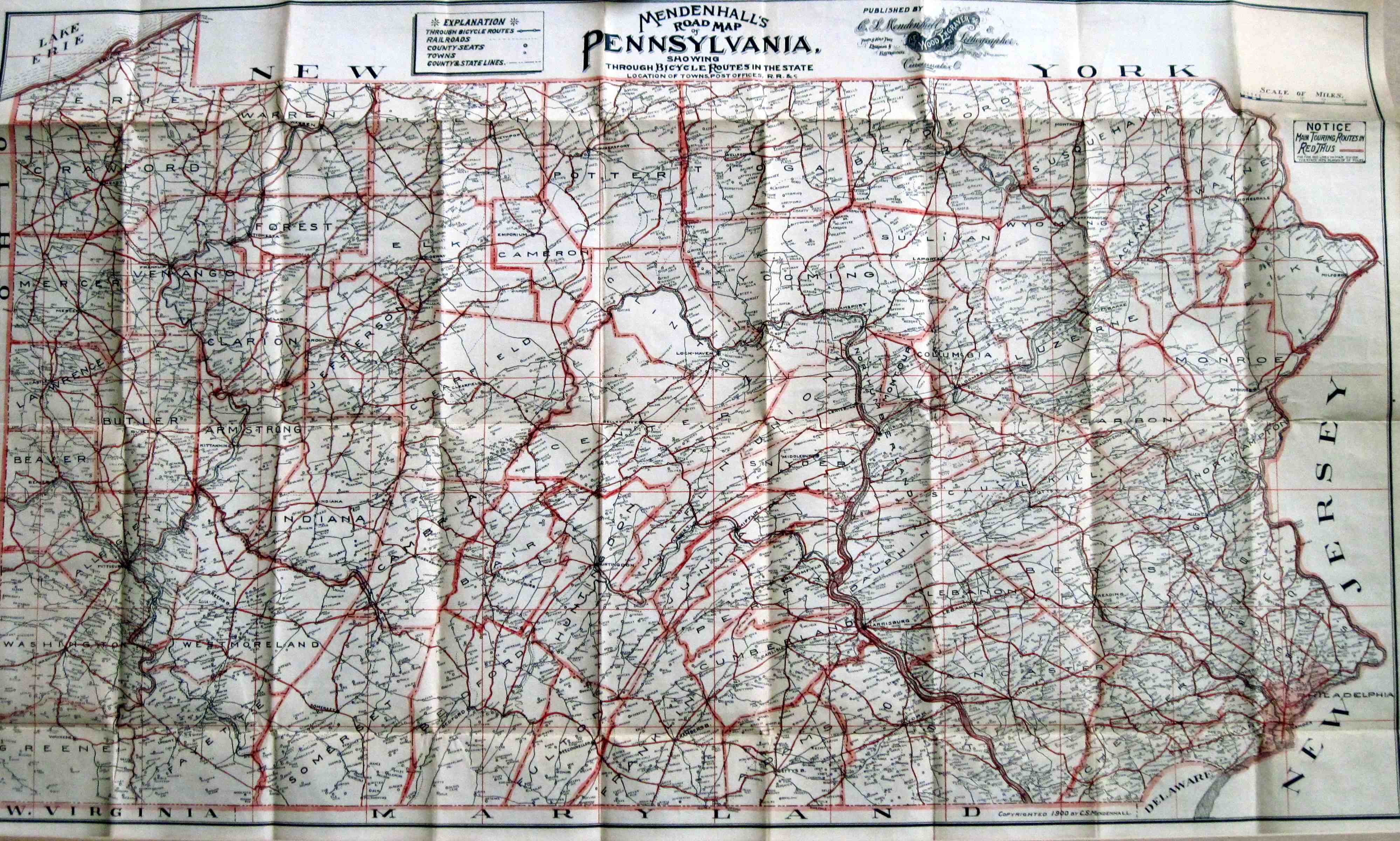