The end of the Revolutionary
War, settled by the Treaty of Paris early in 1783, resulted in
many maps published that year. Maps issued in previous years with
"British colonies" or similar title words were reissued
in the 1780's with "United States" in the title, and
few other changes. The first map of the United States 'compiled,
engraved, and printed by an American' was Abel Buell's A NEW AND
CORRECT MAP OF THE UNITED STATES OF NORTH AMERICA LAYD DOWN FROM
THE LATEST OBSERVATIONS AND BEST AUTHORITY AGREEABLE TO THE PEACE
OF 1783, published in 1784. The map is included in Schwartz &
Ehrenberg and other map histories, and shows the American flag
printed on a map for the first time.
Pennsylvania was growing fast
and eight new counties were created in this decade: Washington
County (seat at Washinton) in 1781; Fayette County (Uniontown) in
1783; Franklin County (Chambersburg) and Montgomery County (Norristown)
in 1784; Dauphin County (Harrisburg) in 1785; Luzerne County (Wilkes-Barre)
in 1786; Huntingdon County (Huntingdon) in 1787; Allegheny County
(Pittsburgh) in 1788; Delaware County (seat at Chester, then
Media) and Mifflin County (Lewistown) in 1789.
 |
1780.1
A NEW AND ACCURATE MAP OF THE PROVINCE OF PENNSYLVANIA IN
NORTH AMERICA FROM THE BEST AUTHORITIES, published in the
Universal Magazine, J. Hinton, London, April
1780. The state ends just past the Susquehanna River on
this map. The title is enclosed in an engraving of trees.
The 'boundary line from Philadelphia run in 1739', is
shown which was based upon the 1732 agreement to define
the border with Maryland. This border dispute eventually
resulted in the Mason & Dixon survey completed in
1768, so this map is way behind the times. The separation
from Delaware is also shown. Counties are not shown,
though the original county lines running northwest from
Philadelphia are indicated. This map accompanied an article on Pennsylvania on pages 169, 170, 171. The magazine published maps
of the other colonies with similar title around this same
time and pieces of Pennsylvania are included on some of them. Longitude west from London. See page 677 of
Phillips, Sellers & van Ee #1298, Phillips page 677.
Blank verso. Scale: 1 inch = 14 miles. Size: 12 x 14
inches. |
 |
1780.2
CARTE DES ETATS-UNIS DE L'AMERIQUE SEPTENTRIONALE,
dressee d'apres des cartes Anglaises; par M. Brion de la
Tour, Ingenieur-geographe du Roi, A Paris, chez le S.
Desnos, ingenieur-geographe de Sa Majeste Danoise, rue
Saint Jacques, au Globe. A map of the east coast from
Massachusetts to Georgia. Pennsylvania appears to have
two western boundaries, an irregular boundary from west
of Pittsburgh extending to Lake Erie, and another cutting
off the state short of Pittsburgh. Another map that is
one of the earliest to name the United States. This image
is from the Library of Congress. McCorkle #780.1; Sellers
& van Ee #740-41. |
 |
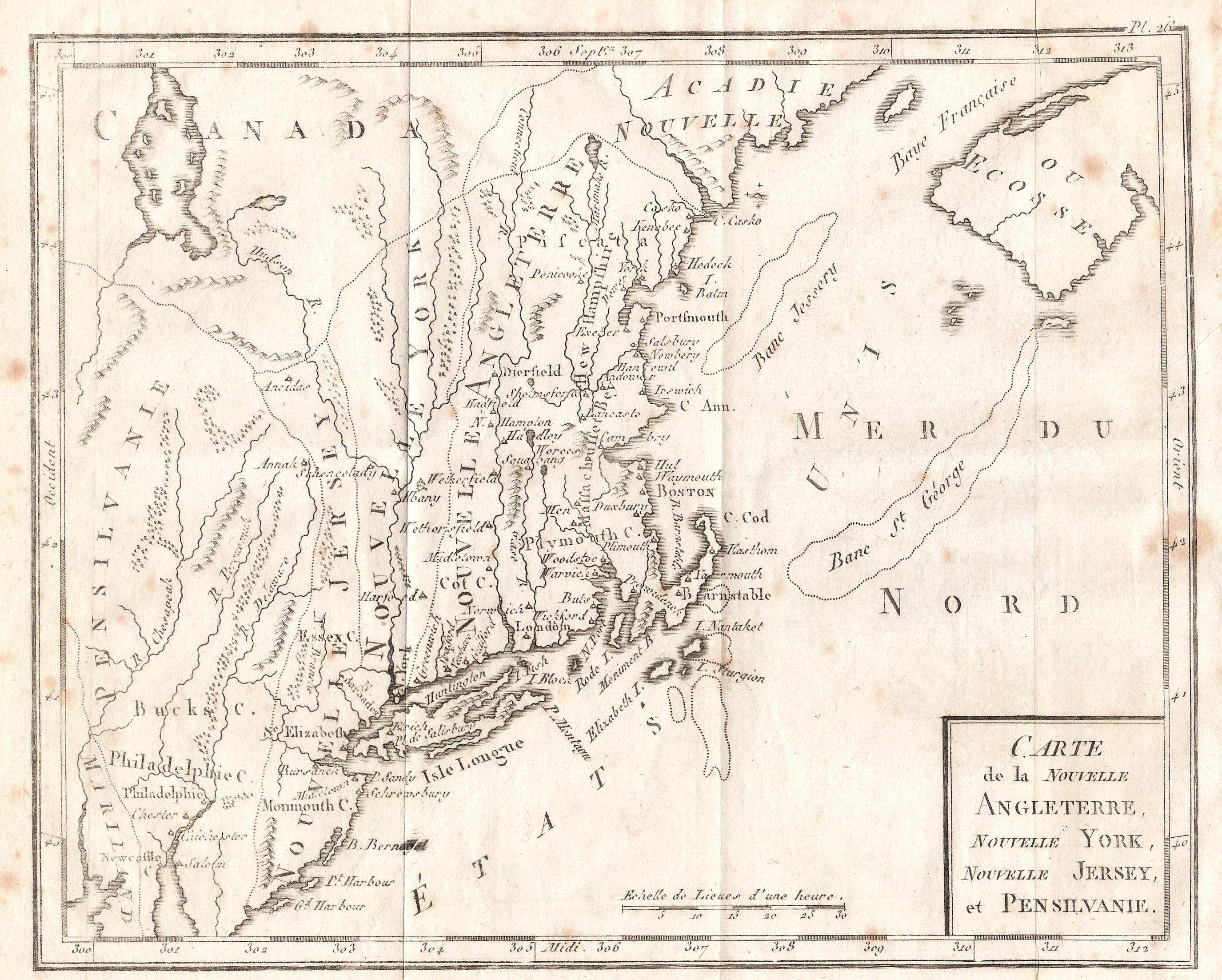
1780.3
CARTE DE LA NOUVELLE ANGLETERRE, NOUVELLE YORK, NOUVELLE
JERSEY, ET PENSILVANIE. A map from editions of Joseph La
Porte's Atlas Moderne portatif, 1780 on (McCorkle
#780.2). The colonies are given strange elongated north-south
boundaries. Philadelphia and Bucks County are identified.
The Susquehanna River is called "Chesapeak",
and the Schuylkill is the "Perquemuk." In other
words, this map displays a French ignorance of the
British colonies. The map was later published in
Bertholon's Atlas Moderne Portitif in 1799 and
that version is shown here. It differs from the original
only in the cartouche. The map was bound on the right
edge and originally folded, so the image is on the verso. It was apparently also published as late as 1812 in Dictionnaire Geographique par Giraud.
Scale: 1 inch = 62 miles. Size: 7 x 9 inches. |
 |
1780.4
CARTE DE LA VIRGINIE ET DU MARILAND. Another map from La
Porte's Atlas Moderne portatif; "Pensilvanie"
is identified at the top, but nothing in the state is
named. This image is the original version with the
fancier cartouche. Scale: 1 inch = 62 miles. Size: 7 x 9
inches. |
 |
1780.5
CARTE REDUITE DES COTES ORIENTALES DE L'AMERIQUE
SEPTENTRIONALE... . This French sailing map of the
northeast coast from the Department de la Marine just
barely includes Pennsylvania, which is named on the map
but not in the title. It appeared in Neptune Americo-Septentrional,
Paris 1780. McCorkle #780.3; Sellers & van Ee #215-16.
Image from the Heritage Map Museum by permission. |
 |
1780.6
CARTE REDUITE DES COTES ORIENTALES DE L'AMERIQUE
SEPTENTRIONALE Contenant Partie du Nouveau Jerfey, la Pen~sylvanie,
le Mary~land, la Virginie, la Carolina Septentrionale, la
Caroline Meridonale et la Georgie. This map of the
southeast coast is a companion to the one above from Neptune
Americo-Septentrional, Paris 1780. Here Pennsylvania
is named in the title but only a sliver of the state
appears on the map. Image from the Heritage Map Museum by
permission. |
 |
1780.7
BRITISH DOMINIONS IN AMERICA, drawn from the latest and
best authorities by Thos. Kitchin, hydrographer to his
Majesty. Engrav'd for Guthrie's new geographical Grammer.
This is a map from William Guthrie's New System of
Modern Geography, London 1780, 1782. The map shows
the familiar east coast from Newfoundland to Florida and
west to the Mississippi. It is hardly from the "latest
and best authorities" since the United States is not
mentioned. Pennsylvania is shown with an irregular
western boundary and with the northern boundary extending
to 43 degrees. This copy is from the 1782 edition; it was originally folded and this has caused a faint impression on the map. McCorkle #780.6. Hand outline color, intaglio print, blank verso. Longitude west from Greenwich. Scale:1 inch = 141 miles. Size: 13.25 x 14.5 inches. |
| |
1780.8
A NEW AND ACCURATE MAP OF THE PROVINCE OF NEW YORK AND
PART OF THE JERSEYS, NEW ENGLAND AND CANADA, shewing the
scenes of our military operations during the present war.
Also the new erected state of Vermont. London. Published
as the Act directs. Octr. 31st. 1780. By J. Bew, Pater
Noster Row. Jn. Lodge sculp. This is a magazine map from
the Political Magazine. Athough not mentioned in
the title, northeast Pennsylvania appears on this map
with Bucks and Northampton counties named. The northern
boundary is placed at about 42d 4m, or just slightly
north of its present day location. McCorkle #780.9;
Sellers & van Ee #176. |
| |
1780.9
A NEW AND CORRECT MAP OF NORTH AMERICA in which the
places of the principal engagements during the present
war, are accurately inserted. London. Published as the
Act directs. April 26th. 1780. By I. Bew, Pater Noster
Row. Jno. Lodge sculp. Another map from the Political
Magazine showing the usual region from Newfoundland
to a cutoff Florida and west to beyond the Mississippi.
The northern boundary of Pennsylvania extends to 43
degrees with an irregular western boundary that is the
mirror image of the eastern. McCorkle #780.10, 783.14. |
| |
1780.10
THE UNITED STATES OF NORTH AMERICA, WITH THE BRITISH
& SPANISH TERRITORIES. A map of uncertain date that
appeared in a very late edition of Herman Moll's Atlas
Minor. The map first appeared in 1729, see 1729.3,
and like many others was updated to include the new
United States. If this date is correct, it is one of the
earliest maps to name the United States. McCorkle #780.11 |
| |
1780.11
A CHART OF THE COAST OF NEW YORK, NEW JERSEY, PENSILVANIA,
MARYLAND, VIRGINIA, NORTH CAROLINA, &C. Composed from
the deposit of surveys of the right honourable the Lords
of Trade, with soundings and nautical remarks from Lt.
Jno. Knight of the navy & others. By Jos. Fred. W.
Des Barres Esqr. 1780. This nautical chart appeared in
several editions of Des Barres' Atlantic Neptune
as listed by Sellers & van Ee #766-67. It is
illustrated in Pritchard & Taliaferro #61. The
southeastern tip of Pennsylvania is included, hills and
valleys are shown with detailed hachures. |
 |
1780.12
A MAP OF THE LAND ABT. RED STONE AND FORT PITT, GIVEN TO
ME BY CAP. CRAWFD. This is an anonymous manuscript map
with annotations by George Washington done circa 1780 per
Sellers & van Ee #1332. The map itself was probably
prepared earlier by "Cap. Crawfd," and may date
circa 1758-71. It shows the river system around
Pittsburgh, located at upper right. "Crawfd" is
undoubtedly Colonel William Crawford for whom Crawford
County in Pennsylvania is named. He was a long time
friend of Washington who survived the French & Indian
War, Pontiac's Rebellion, and the Revolution, only to be
burned at the stake in 1782 while leading an expedition
into Ohio. This image is from the Library of Congress. |
 |
1780.13
CAMPAIGN OF MDCCLXXVI. The date of this manuscript map is
uncertain. The Library of Congress, from where this image
comes, dates it 1780? and that is followed here. The main
map is of the middle Atlantic region with an inset of the
Delaware River titled CAMPAIGN OF MDCCLXXVII. This was
the British capture of Philadelphia. |
 |
1780.14
A NEW AND ACCURATE MAP OF VIRGINIA AND PART OF MARYLAND
AND PENNSYLVANIA, London Publish'd as the Act directs 31st
of Decr 1780. J. Bew, Pater Noster Row. Jn.o Lodge sculp.
This map was published in the Political Magazine,
London December 1780. It is listed in the Maryland State
Archives, MSA SC 1399 -1-52, and is a companion to map
1780.8 above. A copy of this map can be seen at the Darlington Library. Only a thin strip of southern Pennsylvania is shown at the top, however the name is in the title. Fort Pitt is located too far south, Delaware has an odd shape. Blank verso, intaglio print. Longitude west from London. Scale: 1 inch = 27 miles. Size: 10.5 x 14.5 inches.
|
| |
1780.15
AN ACCURATE MAP OF NEW YORK IN NORTH AMERICA, FROM A LATE
SURVEY, from the Universal Magazine, London 1780.
Despite the title, this typical magazine map includes a
healthy chunk of northeastern Pennsylvania as well as a
piece of Connecticut and New Jersey. Sellers & Van Ee
#1112. |
 |
1781.1
LES ETATS UNIS DE L'AMERIQUE SEPTENTRIONALE, CONTENANT EN
OUTRE, LES ISLES ROYALE, DE TERRE NEUVE, DE ST. JEAN ET L'ACADIE;
AVEC PARTIE DU CANADA, DE LA LOUISIANE ET DE LA FLORIDE.
Par M. Bonne, Ingenieur-hydrographe de la Marine. Juillet,
1781. A map of the east coast from Newfoundland to
Florida, which appeared in Atlas portatif a l'usage
des colleges by Abbe Grenet (McCorkle #781.3;
Sellers & van Ee #742). Originally folded in the
middle. Longitude from Paris, blank verso. Scale: 1 inch
= 250 miles. Size: 8.5 x 12.5 inches. |
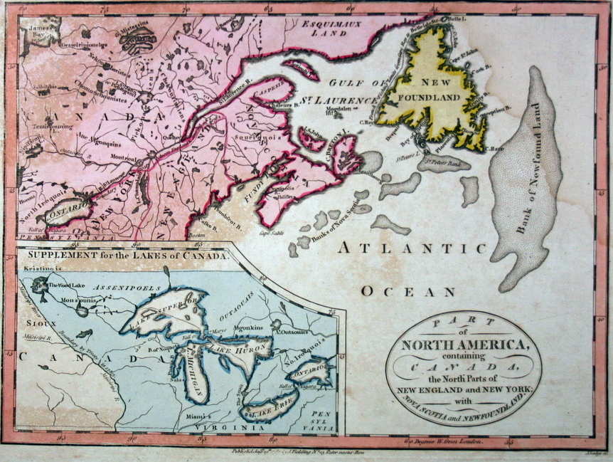 |
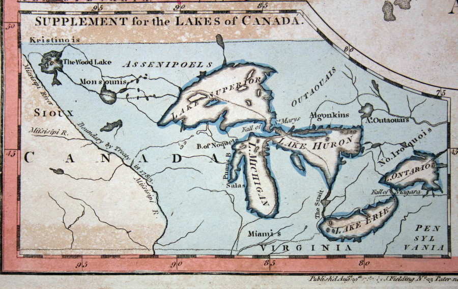
1781.2
PART OF NORTH AMERICA, CONTAINING CANADA, THE NORTH PARTS
OF NEW ENGLAND AND NEW YORK; WITH NOVA SCOTIA AND
NEWFOUNDLAND. J. Cary sculp. Published Novr. 24, 1781, by
I. Fielding No. 23 Pater noster Row (McCorkle #781.5).
Pennsylvania only barely appears on the bottom of the
main map and only because its northern boundary is set
just past 43 degrees. An
inset
titled "Supplement for
the Lakes of Canada" shows the Great Lakes and also
includes a named Pennsylvania. There was a later edition
of this map "Published Augst. 29th 1785 by I.
Fielding..., J. Lodge sc." which is the one shown
here. It is identical to the earlier one. According to
McCorkle, the earlier map appeared in Complete
Geographical Dictionary by John Seally, London 1783-84;
and the later one appeared in editions of Guthrie's Universal
Geography Improved. |
| |
1781.3
CARTE DU CANADA OU DE LA NOUVELLE FRANCE... Revue et
augmentee en 1781. A Paris chez De Zauche successeur des
Sre. De l'Isle et Buache... Ph. Buache P. G. de d. l'A. R.
de S. Gendre de l'Auteur. This is a very late issue of a
map originally by De'Lisle, see map 1703.1, reveiwed and
augmented in 1781 as the inscription says. McCorkle #781.7 |
 |
1781.4
LA VIRGINIE, PENNSILVANIE, NOUVELLE ANGLETERRE, et autres
pays fesant partie des possessions Angloises, en Amerique.
Suivant les dernieres observations. Par J. Bte. Nolin.
1781. This map, extending from Maine to the Chesapeake
and west to include Lake Michigan, is from Nolin's Atlas
general a l'usage des colleges et maisons d'education,
Paris 1783 (McCorkle #781.9). The map is way out of date; a boundary line confines
the English colonies to the coast; "F. Duquene"
is named along with "Fort Francois" on the
upper Allegheny. It appears made as if the French & Indian War never occurred. Another edition of the atlas in 1791 contained this same map. This copy has later color, some loss along the center, and is closely trimmed to the neat line. Scale: 1 inch = 120 miles.
Size: 8 x 10 inches. |
 |
1781.5
PARTIE OCCIDENTALE DE LA VIRGINIE, PENSYLVANIE, MARYLAND,
ET CAROLINE SEPTLE. LA RIVIERE D'OHIO, Par Hutchins.
Paris Le Rouge, 1781. This is Le Rouge's version of
Hutchins' western territories map 1778.14. Phillips page
677. This image is from the Library of Congress. |
| |
1781.6
(Delmarva Peninsula) This is an untitled manuscript map
prepared by Robert Alexander, a loyalist, that found its
way into the papers of General Henry Clinton.
Southeastern Pennsylvania is included. It is illustrated
in Papenfuse & Coale. |
 |
1781.7
CARTE DES ENVIRONS DU FORT PITT ET DE LA NOUVELLE
PROVINCE INDIANA Dediee A. M. Franklin. This map comes
from the French edition of Thomas Hutchins' A
Topographical Description of Virginia..., with the
French title Description topographique de la Virginie,
de la Pensylvanie, du Maryland et de la Caroline
Septentrionale: contenant les rivi res d'Ohio, Kenhawa,
Sioto, Cherok e, Wabash, des Illinois, du Mississipi,
&c publie par Thomas Hutchins. It was
translated and published by George Le Rouge in Paris. It
shows the region from Fort Pitt south to Kentucky and
from the Allegheny Front west to the Muskingum River. The
"Indiana" in the title refers to today's West
Virginia. This image is from Winsor (1899). |
| |
1781.8
A MAP OF MARYLAND WITH PART OF VIRGINIA AND PENSYLVANIA.
This map from the December 1781 Scots Magazine,
Andrew Bell engraver, shows most of Maryland, all of
Delaware, eastern Virginia, southeast Pennsylvania, and
southern New Jersey. The title is in the top margin.
Listed in Heritage Map Museum CD and in the Maryland
State Archives. |
 |
1781.9
CARTA DELLA FLORIDA, LUIGIANA E LAGHI DEL CANADA, from an
unknown Italian publication and of uncertain date, this map resembles one
from the French and Indian War era; for example, in
Pennsylvania "Fort Duquene" is shown along with
"Filadelfia." But it dates later as the colonies along the coast are named Provincie Unite, undoubtedly a reference to the nascent United States. This map is believed to come from Voyages Compendio della Storia Generale de' Viaggi Opera published in 1781 by Jean-Francois de la Harpe (1739 - 1803); and was a compendium of the first travel accounts to the new world, including Columbus, Hernandez, Balboa, las Casas, and Cortez. La Harpe was a well known French writer with a rather fascinating career, including being caught up in the French Revolution.The map shows the region from New
York to a cut off Florida and west to the Mississippi;
there are no colonial boundaries and few towns are named. It was originally bound along the left edge and is a copy of earlier Bellin maps. Blank verso, the longitude appears to be west from Ferro. Scale: 1 inch = 160 miles. Size: 9.75 x 6.75. |
 |
1782.1
PARTIE OCCIDENTALE DU CANADA, CONTENANT LES CINQ GRANDS
LACS, AVEC LES PAYS CIRCONVOISINS. PAR M. BONNE,
INGENIEUR-HYDROGRAPHIC DE LA MARINE. 'LIV XV. XVI.
ET XVII.' appears at upper left, 'NO. 45'
at upper right. Rigobert Bonne (c1729-95) was successor
to Bellin as Royal Hydrographer. This map was part of Atlas
de toutes les parties connues du globe terrestre
accompanying Abbe Raynal's Histoire philosophique, and
shows the Great Lakes area. The map (see Fort Duquesne)
was well behind current events. The companion map of the
northeast, which is better known, is shown below. Sellers
& van Ee #173. Originally folded in half, with
'Longitude du Meridien de Paris' at bottom,
blank verso. Scale: 1 inch = 120 miles. Size: 8 x 12.5
inches. |
 |
1782.2
CARTE DE LA PARTIE NORD, DES ETATS UNIS, DE L'AMERIQUE
SEPTENTRIONALE, NO. 47 LIV XVII ET XVIII, by Rigobert
Bonne, also from Atlas de toutes les parties connues
du globe terrestre. The map depicts the east coast
from Viginia to Maine and west to Ohio. Fort Duquesne and
Fort Necessity are marked. There were several versions of
this map circa 1782-85 (McCorkle #782.1; Sellers &
van Ee #744) and there is a companion map showing the
southern states '...PARTIE SUD...'. This is one of the
first maps to carry the name United States, but in French
'Etats Unis.' Italian versions of these Bonne maps appeared in Compendio Della Storia Generale de' Viaggi Opera di m. de la Harpe Accademico Pariging, adorna di carte geografiche, e figure arricchita d annotazioni Tomo Vigesimoquinto Venezia 1784. Longitude is west from Paris at the bottom
and east from Ferro at the top. Blank verso. Scale: 1
inch = 65 miles. Size: 9.75 x 14 inches. |
| |
1782.3
CARTE GENERALE DES TREIZE ETATS-UNIS & INDEPENDENTS
DE L'AMERIQUE SEPTENTRIONALE d'apres Mr. Bonne, ingenieur
hydrographe de la Marine de France. 1782. H. Klockhoff
sculp Amst. A map of the east coast, the depiction of
Pennsylvania is much like that in the map above. There
were several versions of this map as illustrated by
McCorkle #782.2, 784.9. |
 |
1782.4
L'ISLE DE TERRE-NEUVE, L'ACADIE, OU LA NOUVELLE ECOSSE, L'ISLE
ST. JEAN, ET LA PARTIE ORIENTALE DU CANADA. Par M. Bonne,
Ingr. Hydrographe de la Marine. Another map from Atlas
de toutes les parties connues du globe terrestre that
extends the coverage of the northeast to Newfoundland.
Pennsylvania and New York just make it onto the western edge. Several
versions are illustrated in McCorkle #782.3; also Sellers
& van Ee #172. This map has also been seen dated 1779 from the same atlas. Intaglio print, blank verso. Longitude from Paris at bottom; from Ferro at top. Scale: 1 inch = 117 miles. Size: 8 x 12.25 inches. |
 |
1782.5
CARTE DE LA PENSYLVANIE ET DU NOUVEAU JERSEY. ECHELLE, by
Rigobert Bonne or possibly Brion de la Tour, Plate 6 believed to be from Essaishistoriques politiques sur les
Anglo-Am ricains, Par M. Hilliard d'Auberteuil ... A
Bruxelles, 1781-82. Pennsylvania boundaries are shown by
line color from about 39d 45m to 42d. The western
boundary is just west of the Allegheny ridge and east of
Fort Pitt, with the west marked as Indian country. Many
early towns and forts are identified. The outline
coloring is probably later. Phillips page 678. Longitude
west from Paris at top, east from Ferro at bottom, blank
verso. Scale: 1 inch = 31 miles. Size: 9.25 x 13 inches. |
| |
1782.6
CARTE DE LA NOUVELLE YORK, y-compris les terres cedees du
N. Hamp-Shire, sous le nom d'Etat de Vermont. Vermont
declared itself independent from New Hampshire in 1777,
but was not admitted as a state until 1791. This map
includes eastern Pennsylvania on the west but nothing in
the state is named. The map is attributed to Brion de la
Tour from Essais historique et politique... by d'Auberteuil,
and is a companion to map 1782.5 above. McCorkle #782.5. |
 |
1782.7
CARTE DE L'AMERIQUE SEPTENTRIONALE, DEPUIS LA BAYE D'HUDSON JUSQU'AU MISSISSIPI: POUR SERVIR AUX EFFAIS HIFTORIQUES ET POLITIQUES SUR LA REVOLUTION DE CETTE PARTIE DU MONDE. A map from Essais Historique et Politique... by D'Auberteuil. This map is usually attributed to Louis Brion de la Tour as his name appears on other maps in the Essais. Pennsylvania is shown extending to 43 degrees with an uneven western border. The map extends beyond the neat line at top and bottom and displays the region from southern Labrador to a misshapen Florida; and extending west to the Mississippi. McCorkle #782.6; Sellers & Van Ee #179. Longitude west from Paris; blank verso. Scale: 1 inch = 120 miles. Size: 16 x 15 inches.
|
 |
1782.8
PART OF NORTH AMERICA, COMPREHENDING THE COURSE OF THE
OHIO, NEW ENGLAND, NEW YORK, NEW JERSEY, PENNSYLVANIA,
MARYLAND, VIRGINIA, CAROLINA & GEORGIA. J. Cary
sculpt Published Jany. 19 1782, by I. Fielding No. 23
Paternoster Row. This map comes from the Complete
Geographical Dictionary by John Seally circa 1783-84.
It is a copy of the 1755 de Vaugondy map, see 1755.20,
and shows the northeast with an inset of the Carolinas.
The same plate was used in later geographies as mentioned
by McCorkle #782.9. This map is a companion to map 1781.2
above and both were published together. Scale: 1 inch = 110 miles. Size: 8.5 x 11.5 inches. |
 |
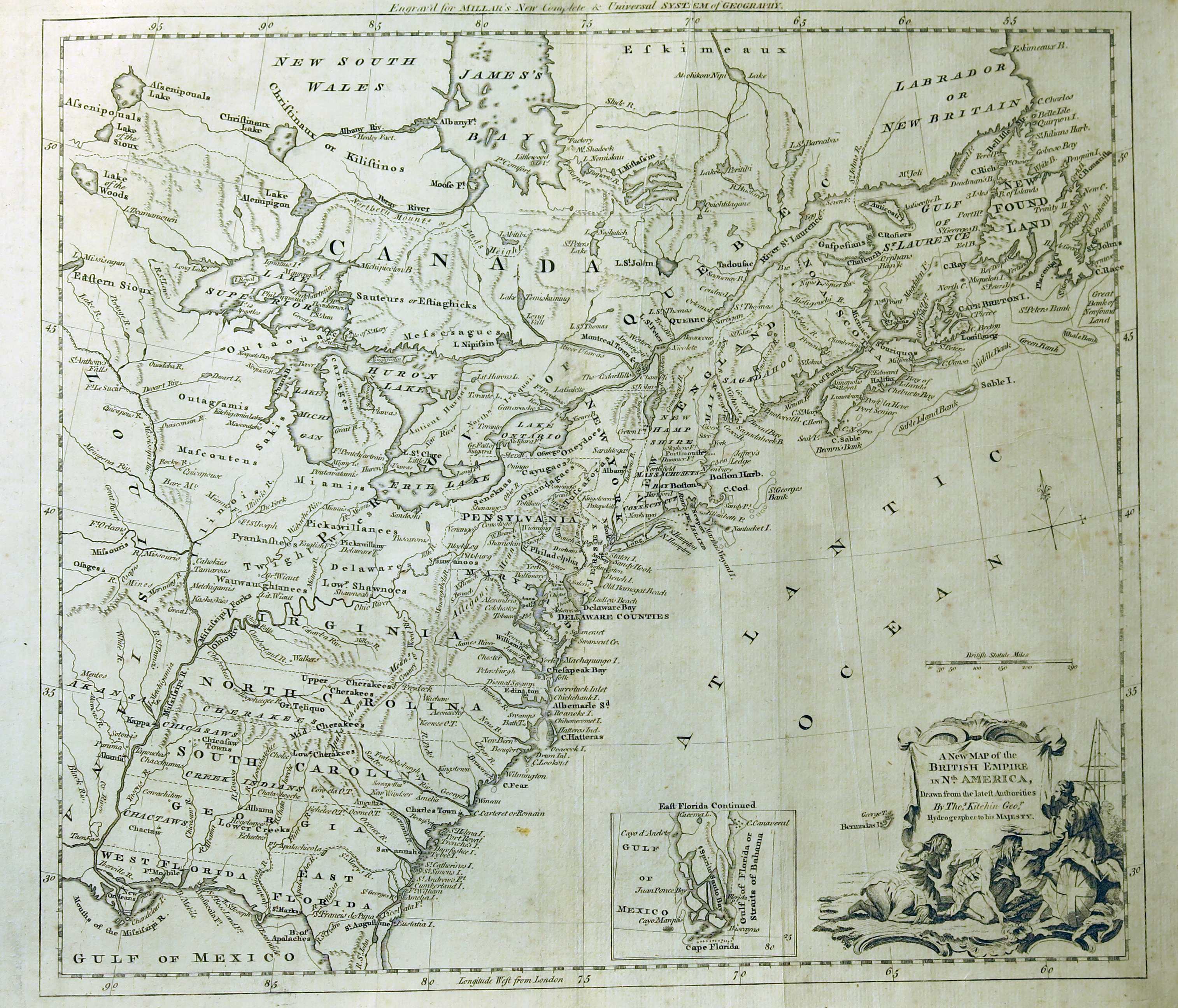
1782.9
A NEW MAP OF THE BRITISH EMPIRE IN NTH. AMERICA, drawn
from the latest authorites by Thos. Kitchin geor.
hydrographer to his Majesty. Engraved for Millar's New
Complete & Universal System of Geography. The source
of this map of the east from Newfoundland to Florida and
west to the Mississippi is given in the line across the top. There is
an inset of southern Florida. The map is out of date,
Pennsylvania is shown extending to 43 degrees with an
irregular western boundary that is the mirror image of
the eastern. Note that this map is essentially identical to map 1780.7. This same geography contains a page with
five small maps titled VARIOUS PLANS AND DRAUGHTS OF
CITIES, TOWNS, HARBOURS &C. The cities are New York,
Boston, Philadelphia, Charlestown (SC) and Havanna.
McCorkle #782.10; Sellers & van Ee #180. Blank verso, longitude west from London. Scale:1 inch =140 miles. Size: 13 x 15 inches. |
| |
1782.10
NAUWKEURIGE KAART VAN DE XIII PROVINTIEN DER VEREENIGDE
STAATEN VAN NOORD AMERICA. Te Amsterdam bij Allart en
Holtrop. P. Mol sculps. J. C. Roeder fec: et delin. A map
from Nieuwe Reize door Noord-Amerika in den jaare
1781 by Abbe Robin 1782. It shows the east from Nova
Scotia to Georgia and west to the Mississippi.
Pennsylvania extends to 43 degrees with an irregular
western boundary; the southern states extend to the
Mississippi. McCorkle #782.12 |
 |
1782.11
A NEW & ACCURATE MAP OF THE PROVINCE OF CANADA, IN NORTH AMERICA; FROM THE LATEST AND BEST AUTHORITIES. London Published as the Act directs, 31st. July 1782 by J. Bew, Pater Noster Row. This map appeared in the Political Magazine of July 1782 as indicated at the top right corner. Coverage extends from James Bay south to 40 degrees, and so includes almost all of Pennsylvania, whose northern boundary extends to 43 degrees. The state's western boundary appears to be shown near its present position west of Pittsburgh (Pittburg on the map). Towns and rivers are named and Indian tribal areas. The Great Lakes are reasonably delineated, except for southern Lake Michigan. McCorkle #782.13; Sellers & Van Ee #181. Originally folded and attached at the right edge. Intaglio print, blank verso, longitude west from London. Scale: 1 inch = 96 miles. Size: 10 x 13 inches. |
| |
1782.12
BRITISH AMERICA from the best authorities by J. Young
Geog. Printed for John Ainslie land surveyor &
engraver Edinr. and William Faden St. Martins lane Lond.
Published as the Act directs 1st. Jany. 1782. This small
scale map shows all of eastern North America with nothing
identified; the states and cities are noted by letters
which apparently refer to accompanying text, from A
New Atlas by Young. See map 1783.22 below. McCorkle #782.15 |
 |
1782.13
COTE DE YORK-TOWN A BOSTON: MARCHES DE L'ARMEE. This is a
manuscript map of the east coast showing the march of
Comte de Rochambeau's army from New England to Yorktown
and back again. It includes eastern Pennsylvania as shown
in this detail from the Library of Congress. Sellers
& van Ee #743, Phillips page 678.
An untitled printed version of
this map appeared in Francois Soules' Histoire des
troubles de l'Amerique Anglais, published in Paris
in 1787. |
 |
1782.14
CAMP A PHILADELPHIE LE 31 AOUST 16 MILLES DE CHESTER. Le
1re. Septembre Sejour. In Amerique campagne. 1782. A
French manuscript map from Rochambeau's army which was
camped near Philadelphia in 1782. Rochambeau published an
atlas of camp maps in 1782 titled Amerique Campagne
containing about 45 maps, the atlas is in the Library of
Congress from where this image of the Philadelphia camp
comes. A map of a camp at Chester is also in the atlas
which contains about 40 such maps, all now online at the
LOC. Sellers & van Ee #1350, Phillips page 678. M. P.
Snyder in Figures 66,67 illustrates two maps of the
Philadelphia area in the papers of (at Princeton Library)
, and attributed to, Louis-Alexandre Berthier circa 1781
which very much resemble these maps from Rochambeau's
atlas. Also see Docktor
#281B5, #281B5.01, #281R3, #281R3.01
- 03, #282R1, #282R1.01 - 03. |
| |
1782.15
LE TREDICI COLONIE UNITE DELL'AMERICA SETTENTRIONALE Per
Servire Alla Storia Dell' Anno 1781. This Italian map is
listed in
MapForum.Com
, Issue 1, as from Storia
Politica Dell'Anno circa 1782. |
 |
1782.16
AMERICA SEPTENTRIONALIS COLONIIS IN INTERIOREM VIRGINIAM
DEDUCTIS &c. surriptibus Iohannim Michaelim Probst
Aug Vin 1782. This map, seen at auction, is a copy of
Schreibers' map of 1741 of the eastern United States.
Probst has a different title cartouche, but otherwise the
map is essentially unchanged. |
 |
1782.17
CARTE DE LA PARTIE DE L'AMERIQUE SEPTENTRIONALE QUI
COMPREND LES POSSESSIONS ANGLAISES. Hist. Univ. Part. Mod.
Tome 116 Page 134. This map was seen at auction
attributed to Louis Brion de la Tour and dated circa 1782,
probably because it names the new Etats Unis. It covers
the region from Greenland south to the Chesapeake and
west to Lake Superior. The intent is to show "Possessions
Anglaises", or Canada, but the coverage extends far
enough south to include all of Pennsylvania which is
named along with Philadelphia. The map is certainly
French and from Brion's time, and apparently from a book
with histoire universelle in the title; but
no likely source is known. Longitude west from "de l'isle
de Fer", blank verso. Scale: 1 inch = 300 miles.
Size: 8.75 x 10 inches. |
 |
1782.18
CARTE G N RALE DES ETATS UNIS DE L'AM RIQUE SEPTENTRIONALE, RENFERMANT AUSSI QUELQUES PROVINCES ANGLOIFES ADJACENTES, NO. 133. Tardieu, sculpt; Andre, scrip. This map was drawn by Gaspard Andr , engraved by Pierre-Fran ois Tardieu, and (likely) published in Atlas Nouveau, by Edme Mentelle, Paris, 1782. It shows the eastern United States and southern Canada from Newfoundland to Florida and west to the Mississippi. At lower right, 14 states are named with their capitols, the Pennsylvania capitol still Philadelphia. This is a good example of an old map reissued with a new title (i.e. Etats-Unis) because of the creation of the United States. Some features are out of date, i.e. Fort Necessity, and not much is really named. Intaglio print. Blank verso, longitude east from Ferro at top, from Paris at bottom. Scale: 1 inch =160 miles. Size: 12.5 x 16.75 inches. |
| |
1783.1
THE UNITED STATES OF AMERICA WITH THE BRITISH POSSESSIONS
OF CANADA, NOVA SCOTIA, AND NEWFOUNDLAND, divided with
the French; and the Spanish territories of Louisiana and
Florida according to the preliminary articles of Peace
signed at Versailles the 20th of Jany. 1783. London.
Printed for R. Sayer and J. Bennett, Map and Printsellers,
No. 53 Fleet Street, as the Act directs, 9th February.
1783. This is an example of an older map (1755.5)
reissued with a new title containing United States;
followed by later printings, see
MapForum.Com
, Issue 1 and McCorkle #783.1,
794.1; Sellers & van Ee #752. |
| |
1783.2
BOWLES'S NEW POCKET MAP OF THE UNITED STATES OF AMERICA:
the British possessions of Canada, Nova Scotia, and
Newfoundland with the French and Spanish territories of
Louisiana and Florida...., Printed for & sold by the
Proprietor Carington Bowles... 1783. Another example of
an older map (1768.3) reissued with United States in the
title. There were several later editions, see
MapForum.Com
, Issue 1, and McCorkle #783.3,
784.1, 795.1; Sellers & van Ee #745. |
 |
1783.3
CARTE DES ETATS-UNIS D'AMERIQUE, ET DU COURS DU
MISSISSIPI; redigee d'apres differentes cartes et
relations Anglaises..., composee par le Sr. Brion de la
Tour... . This map shows the region from Nova Scotia to a
cutoff Florida and west to beyond the Mississippi.
Pennsylvania's western boundary is pushed into Ohio and
its northern boundary appears undefined. This image is a
1784 version from the Library of Congress. McCorkle #783.4,
784.2, 787.2; Sellers & van Ee #746. |
| |
1783.4
AN ACCURATE MAP OF THE UNITED STATES OF AMERICA WITH PART
OF THE SURROUNDING PROVINCES agreeable to the Treaty of
Peace of 1783. By Ino. Cary. London, published as the Act
directs, Augt. 6, 1783, by John Cary, map &
printseller, No. 188, the corner of Arundel Street,
Strand. This is a map of the eastern United States from
Maine to a cutoff Florida and west to beyond the
Mississippi. The northern boundary of Pennsylvania
appears to extend to Lake Ontario, there is no western
boundary. The map can be seen at the Darlington Library. McCorkle #783.5; Sellers & van Ee #747. |
| |
1783.5
A NEW MAP OF THE UNITED STATES OF NORTH AMERICA with the
British Dominions... on that continent &c. By Samuel
Dunn, Mathematician; Improved from the Surveys of Cap.t
Carver. London, Printed For Rob.t Sayer & Jn.o
Bennett, N.o 53, Fleet Street, As The Act Directs, Oct. 9
1783. This map is from Dunn's Atlas of the Mundane
System, 1783. This is a reissue of map 1774.4 with a
new title and changes showing the creation of the Unites States; it was reissued with minor changes in 1786 and 1794. McCorkle #783.6, 794.5. |
| |
1783.6
CARTE GENERALE DES ETATS UNIS DE L'AMERIQUE
SEPTENTRIONALE avec les limites de chacun des dits Etats...
par J. B. Eliot. This is a reissue of map 1777.6 with a
new title. McCorkle #783.7; Seller & van Ee #749. |
 |
1783.7
ETATS-UNIS DE L'AMERIQUE SEPLE. avec le Canada et la
Foride. This map is No. 26 from the Petit Atlas
Moderne... by Rigobert Bonne, Paris 1783. It shows
the United States from Maine to Florida and west to the
Mississippi. Pennsylvania's northern boundary extends to
43 degrees; the western boundary follows the Ohio south
to below the 40th parallel. "Ft. Duquesne" is
named but not Pittsburgh. A table at lower right gives
the capitols of the states. A 1793 version was published
in an atlas by Delamarche. McCorkle #783.8; Sellers &
van Ee #183. Longitude west from Paris, blank verso.
Scale: 1 inch = 225 miles. Size: 10 x 7 inches. |
| |
1783.8
THE UNITED STATES OF NORTH AMERICA, with the British and
Spanish territories..., Wm. Faden 1783. This is a reissue
of map 1777.5 by Faden with a new title. There were
several subsequent issues with revisions. An excellent
reproduction of the 1793 version is shown in van Ermen; and can also be seen at the Darlington Library, which also has the 1796 version.
McCorkle #783.9, 785.6, 793.1, 796.7. |
 |
1783.9
REMARQUES SUR LA NAVIGATION DE TERRE-NEUVE A NEW-YORK
AFIN D'EVITER LES COURRANTS ET LES BAS-FONDS AU SUD DE
NANTUCKETT ET DU BANC DE GEORGE. A Paris ches Le Rouge...
. This is Benjamin Franklin's famous map of the Gulf
Stream which includes the eastern coast from Newfoundland
to Florida. Pennsylvania and the other states are named.
According to McCorkle (#783.10, 786.3, 789.7), who
illustrates three versions, Franklin sent a copy of his
chart to the French marine office, and when he returned
to Philadelphia in 1785 he carried this French chart with
him. This map is also illustrated and discussed in
Pritchard & Taliaferro #62. An earlier version of
Franklin's chart of the Gulf Stream appeared on a circa
1768 map of the Atlantic Ocean which included both North
America and Europe, and so is not listed here; it is
shown in Pritchard & Taliaferro. The image here is
the 1786 version A CHART OF THE GULF STREAM published by
the American Philosophical Society, Vol 2. Pl. 5, with
"A letter from dr. Benjamin Franklin. Containing
sundry maritime observations. August, 1785," and
text titled "Remarks Upon the Navigation from
Newfoundland to New York, In order to avoid the Gulph
Stream." Wheat & Brun #721; Phillips page 592.
Image from the Heritage Map Museum CD by permission. |
 |
1783.10
MAP OF THE UNITED STATES IN NORTH AMERICA: with the
British, French and Spanish dominions adjoining,
according to the Treaty of 1783. By Thos. Kitchin Senr.
hydrographer to his Majesty. Published by T. Cadell
according to Act of Parliament May 1st. 1783. This is a
map of the eastern United States from Newfoundland to a
cutoff Florida and west to the Mississippi. Pennsylvania's
northern boundary extends to 43 degrees and the western
boundary is a mirror image of the eastern. The map
appeared in Philosophical and Politcal History
by Abbe Raynal, London 1783 and later editions. An image
can be seen at
MapForum.Com
, Issue 1. McCorkle #783.11.
This image is from the Library of Congress. Blank verso, longitude west from Ferro. Scale: 1 inch = 105 miles. Size: 16 x 19.75 inches. |
 |
1783.11
ETATS-UNIS DE L'AMERIQUE divises en 13 provinces avec
leurs limites, suivant le Traite de paix fait le Janvier
1783. Par Lamarche geogr? This map shows the eastern
United States from Newfoundland to a badly drawn Florida
and west to the Mississippi. It goes beyond the neat line
at top and bottom. Pennsylvania extends to 43 degrees
with a western boundary into Ohio. The map shown in
McCorkle #783.12 carries the attribution "Par
Lamarche Geogr?" and is from an unknown source. The
image shown here is the exact same map but lacking the
attribution and presumably published a little later. The
dating on the map refers to the Treaty of Paris ending
the Revolution and not the date of publication. Longitude
west from Paris at bottom, east from Ferro at top; blank
verso. Scale: 1 inch = 250 miles. Size: 7.5 x 9 inches. |
| |
1783.12
CARTE DU CANADA QUI COMPREND LA PARTIE SEPTENTRIONALE DES
ETATS UNIS D'AMERIQUE... par Guillaume Del'Isle... Revue
et augmentee en 1783... . This is a very late reissue of
map 1703.1 retitled to include Etats Unis; it extends
south to 40 degrees and Pennsylvania appears at the
bottom. McCorkle #783.13; Sellers & van Ee #182. |
| |
1783.13
PART OF NORTH AMERICA, COMPREHENDING THE COURSE OF THE
OHIO, NEW ENGLAND, NEW YORK, NEW JERSEY, PENNSYLVANIA,
MARYLAND, VIRGINIA, CAROLINA & GEORGIA. J. Lodge sc.
Publish'd Augst. 29th 1783 by J. Fielding No. 29 Pater
Noster Row. There is an inset titled Supplement to
Carolina. The map appeared in The Lady's Encyclopedia
by John Seally, London 1788. McCorkle #783.15 |
| |
1783.14
CARTE DE LA NOUVELLE REPUBLIQUE DE L'AMERIQUE OU LES
TREIZE PROVINCES UNIES contenant: 1. New Hampshire, 2.
Massachusetsbaye, 3. Rhode-Island, & 4. Connecticut,
5. La Nouvelle York, 6. Nouvelle Jersey, 7. La
Pensilvanie, 8. Les comtes de Newcastle, Kent, et Sussex
sur la Delaware, 9. Mariland, 10. La Virginie, 11. La
Caroline Septentrionale, 12. La Caroline Meridionale, et
13. la Georgie, par les freres Lotter a Augsbourg. This
is a new map by Lotter with the enumerated title modeled
on a previous one, map 1776.10. This map broadens the
coverage to west of the Mississippi with many Indian
names. Pennsylvania's northern boundary stops at 42
degrees and the western boundary follows the Allegheny
River. There is some evidence, based on watermarks, that this map was issued by Suetter-Lotter as early as 1777. If so, this would make it the earliest map to identify the United States with the term "NOUVELLE REPUBLIQUE." McCorkle #783.16 |
 |
1783.15
A MAP OF THE UNITED STATES OF AMERICA, as settled by the
Peace of 1783 Published Decr. 1, 1783, by I Fielding,
Pater-Noster Row. European Magazine. This map is from the
European Magazine of November 1783, and also
appeared in History of the War with America...
by John Andrews, London 1785, with the date changed. It
shows the United States from Maine to Georgia and west to
the Mississippi. Pennsylvania extends to 43 degrees with
an irregular western boundary. It can be seen at the Darlington Library.
McCorkle #783.17; Sellers & van Ee #755. Intaglio print, longitude west from London, blank verso. Scale:1 inch = 240 miles. Size: 8.5 x 9 inches.
|
| |
1783.16
CARTE GENERALE DES COLONIES ANGLOISES DANS L'AMERIQUE
SEPTENTRIONALE pour l'intelligence de la guerre presente.
D'apres des manuscrit Anglais par J. B. Nolin... Par R.
Phelipeau... 1783. This map of the eastern United States,
with insets of Chesapeake Bay and southern Florida, is an
anomaly for the time as it does not identify the United
States. It has the same name as a 1779 map that was a reissue of a 1777 map, but is a different map; see map 1777.8. McCorkle #783.18; Sellers & van Ee #751. |
| |
1783.17
NORTH AMERICA INCLUDING THE UNITED STATES AND THEIR
BOUNDARIES, agreeable to the Peace, of 1783. Published
June 1st. 1783, by J. Fielding No. 23 Paternoster-Row.
This map comes close to exceeding the regional bounds for
inclusion as it extends past northern Labrador and east
to include the Azores. However, it contains portraits of
Washington and Franklin in the title cartouche with a
simplified depiction of the states. It is from The
Polite Traveler..., London 1783. An image can be
seen at
MapForum.Com
, Issue 1. McCorkle #783.19 |
 |
1783.18
THE UNITED STATES OF AMERICA laid down from the best
authorities, agreeable to the Peace of 1783. Published
April 3d. 1783, by the proprietor John Wallis, at his Map-Warehouse,
Ludgate Street London. A map showning the region from
Newfoundland to Florida and west to beyond the
Mississippi; Pennsylvania extends to 43 degrees with an
irregular western boundary just past Pittsburgh. The
southern states extend to the Mississippi. Wallis must
have had a lot of maps to need a "warehouse."
There was also an untitled state of this map as listed in
MapForum.Com,
Issue 1, published 18 March,
1783. The map title appears as an oval in the center of a group
of figures. To the left of the oval is George Washington
leading Liberty; above Washington is a trumpeting angel
clutching a laurel wreath. To the right is a seated
figure of Benjamin Franklin writing History and
accompanied by Wisdom and Justice. There is also an image of the flag, and this is one of the first maps, possibly the first, to include this image. The map is illustrated
in Ristow; also McCorkle #783.21; Sellers & van Ee #754;
Pritchard & Taliaferro #69. It can also be seen at the Darlington Library; and at the Library of Congress which is the image shown here.
|
| |
1783.19
(Eastern United States) An untitled manuscript map
attributed to David Hartley, a British commissioner who
negotiated the treaty ending the Revolutionary War. The
map shows the 13 colonies with the west divided into 14
new states, each numbered. Pennsylvania extends to about
42d 30m with its southern boundary extended west to the
Ohio River. It is illustrated in Brown #52 and Johnson (1974),
the original is in the William Clements Library. |
| |
1783.20
ANDREW'S NEW MAP OF THE UNITED STATES OF NORTH AMERICA,
Together With Canada, Nova Scotia, Newfoundland, the
Floridas, West Indies, Bay of Honduras, Mosquito Shore,
and Part of Terra Firma, Compiled from Lopez's 4 Sheet
Map of the West Indies: Cuba, from a Spanish Manuscript:
all the Sands, from Dutch & French Charts: America,
from the best Surveys, and Divided according to the
Treaty of Peace 1783. London, Publish'd as the Act
directs, February 12th 1783 by John Andrews No.2a,
opposite Air Street, Piccadilly, & John Harris, No. 3,
Sweetings Alley, Cornhill. This map is listed at
MapForum.Com
, Issue 1. |
 |
1783.21
CARTE DES ETATS-UNIS DE L'AM RIQUE SEPTENTRIONALE,
dress e d'apr s des Cartes Anglaises; Par M. Brion de
la Tour, Ing nieur-G ographe du Roi. A Paris, Chez le S.
Desnos, Ing nieur-G ographe de Sa Majest Danoise, rue
Saint Jacques, au Globe. This map is from Brion de la
Tour's Almanach Int ressant 1783, and an image
can be seen at
MapForum.Com
, Issue 1. It shows the east
coast from Maine to Georgia and west to Lake Michigan.
Pennsylvania ends at the Allegheny Front. Fort Pitt,
Bedford, F. Burd, F. Venango are shown along with
Philadelphia, York, Lancaster, and Chester. There are two
versions, one with a printed frame and one without; see map 1780.2 above. Blank
verso, longitude east from Paris. Scale: 1 inch = 100
miles. Size: 10.5 x 12 inches. |
 |
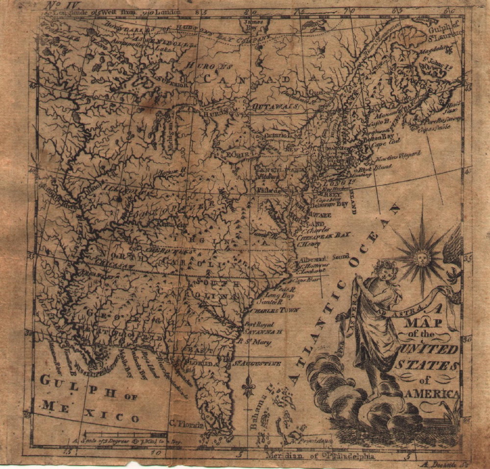
1783.22
THE UNITED STATES OF NORTH AMERICA WITH THE BRITISH TERRITORYS ACCORDING TO THE TREATY 1783. Published as the Act directs. This anonymous British map is a later issue of map 1782.12 above, possibly from a magazine and originally folded. The date in the title is used here as the actual date of issue is not known; it could have been issued as late as the early 1800s. The coverage extends from Labrador to Florida and west to beyond the Mississippi. All of Hudsons Bay is included. The states in New England are not differentiated and Delaware is not identified. The geographical features of the map are identical to the 1782 map, but the names of towns, the title, etc. are a later addition and show signs of at least two reworkings of the plate. This map was seen at auction as being from The General Gazetteer or Compendious Geographical Dictionary, Second Edition. Berwick: Printed and Sold by Wm Lochead - preface dated 1818. This book was originally compiled by R. Brookes in the 1760s and reissued by various publishers up to the 1820s. If this is the source, then the old maps in it were reused also. Blank verso, longitude west from London. Scale: 1 inch = 320
miles. Size: 9.25 x 8 inches. |
 |
1784.1
A NEW AND CORRECT MAP OF THE UNITED STATES OF NORTH
AMERICA layd down from the latest observations and best
authority agreeable to the peace of 1783 humbly inscribed
to his Excellency the Governor and company of the State
of Connecticut by their most obedient and very humble
servant Abel Buell. Newhaven published according to Act
of Assembly. Since this map was sponsored by Connecticut,
it shows that state's extravagant land claims to the west.
This is considered the first map of the United States
published in the United States. In 2010 the New Jersey Historical Society copy was auctioned and sold for over two millon dollars; the buyer has apparently donated it to the Library of Congress. The auction house located only seven known examples surviving. This image is from a
modern reproduction. McCorkle #784.3; Wheat & Brun #109,
110. |
 |
1784.2
A MAP OF THE UNITED STATES OF AMERICA. This map appeared
in Geography Made Easy by Jedidiah Morse, New
Haven 1784, considered the first geography published in
the United States. Pennsylvania's northern boundary is
set correctly at 42 degrees. The second edition appeared
in 1790 from which the image here comes. According to
McCorkle (#784.5), this map is identical to the one in
the first edition except for Dolittle's name added to the
plate. This version with the name first appeared in
Nathan Salomon's An Astronomical Diary ... in
1785. The third edition of the Geography
appeared in 1791 and it went to 18 editions up to 1816.
Wheat & Brun #112. Blank verso. Scale: 1 inch = 345
miles. Size: 5.5 x 5.25 inches. |
 |
1784.3
PENSILVANIAE, NOVAE-CAESAREAE, NOVI-EBORACI,
AQUANISHUONIGAE, ET CANADA, BREVIS DELINEATIO, juxta
itinera P. Kalm a Ludovico Evans. 1750. Aeri incisa a Fr.
Akrel, cura S. Kreander, 1784. McCorkle (#784.6)
speculates this map comes from a Swedish edition of Peter
Kalm's Travels... see map 1771.1. It
extends west as far as the Forks of the Ohio identifying
"Logs T." Pennsylvania's boundaries are
correctly shown. This image is from the Library of
Congress. Sellers & van Ee #705. |
 |
1784.4
CHARTE UBER DIE XIII VEREINIGTE STAATEN VON NORD-AMERICA,
entworfen durch F. L. Gussefeld, und herausgegeben von
den Homaennischen Erben. Mit Romisch Kayserl. allergn.
Freyheit Ao. 1784. There is a French title above the map
LES XIII ETATS UNIS DE L'AMERIQUE SEPTENTRIONALE... .
This map appeared in Homann Heirs atlases enumerating the
original 13 states. It shows the eastern United States
from Nova Scotia to a cutoff Florida and west to beyond
the Mississippi. Pennsylvania is shown with nearly
correct north and south boundaries but with an irregular
western boundary following the Allegheny River. The image
here is of the Pennsylvania region including a portion of
the title cartouche. The coloring is probably a later
addition. McCorkle #784.7; Sellers & van Ee #757.
Blank verso, with the longitude (apparently) east of
Ferro. Scale: 1 inch = 85 miles. Size: 18 x 22.5 inches. |
 |
1784.5
KARTE DES OESTLIECHE ODER EHEMAHLIGE ENGLISCHEN AMERIKA
nach den Besitzungen und Graenzen nach dem Frieden von
1783. This map has the familiar view of eastern North
America from Newfoundland to Florida and west to beyond
the Mississippi; Pennsylvania extends to 43 degrees. This
map comes from a German book on North America by Johan
Jakob Moser titled Nord-America nach den
Friedenschlussen vom Jahr 1783, published in 1784;
thus the dating used here despite the date on the map.
McCorkle #784.8; Sellers & van Ee #185. Longitude
west from London (Westliche Laenge von London), blank
verso. Scale: 1 inch = 255 miles. Size: 8.75 x 11.25
inches. |
| |
1784.6
CARTE DES ETATS-UNIS DE L'AMERIQUE suivant le Traite de
Paix de 1783. Dediee et presentee a s. excellence Mr.
Benjamin Franklin ministre plenipotentiaire des Etats-Unis
de l'Amerique pres la Cour de France, anc Presid de la
conventio. de Pensilvanie et de la Societe Philosophique
de Philadelphie, &c. &c. Par ... Lattre. 1784.
Note the dedication to Franklin. The map shows the
familar region from Newfoundland to a cutoff Florida and
west to beyond the Mississippi. Pennsylvania has an
irregular western boundary and extends past Lake Erie in
the north. There is an inset of Florida and the cartouche
is a beautiful drawing of a ship with the title on the
sail. Illustrated in Ristow; McCorkle #784.10; Sellers
& van Ee #750; Pritchard & Taliaferro #70. |
 |
1784.7
THE UNITED STATES according to the definitive treaty of
peace signed at Paris, Septr. 3d. 1783. ... by Wm.
McMurray, late asst. geogr. to the U.S. R. Scot sculp.
This is a very nice map with the western territories cut
up into potential states and an inset of the United
States extending to the Pacific; McMurray was looking
ahead. Illustrated in Ristow; McCorkle #784.11; Sellers
& van Ee #758; Wheat & Brun #111. It can also be seen at the Library of Congress which is the image shown here. |
 |
1784.8
DIE VEREINIGTEN STAATEN VON NORD=AMERICA. nach der von Wm.
Faden 1783 ... genau zusammengetragen von D. Sotzmann.
This map, after Faden, appeared in several German
histories circa 1784-85. It shows the eastern United
States to beyond the Mississippi; Pennsylvania appears to
extend to Lake Ontario. This image is from the Library of
Congress. There was a later version published in Matthias
Christian Sprengel's Historisches Taschenbuch 1785,
which can be seen at
MapForum.Com
, Issue 1. McCorkle #784.12;
Sellers & van Ee #753. |
| |
1784.9
SKETCH OF THE SURPRISE OF GERMAN TOWN. by the American
Forces commanded by General Washington. October 4th 1777;
by J. Hills, Lt 23d Regt. & Asst. Engr. London, Wm.
Faden, 1784. This battlefield map is illustrated on pages
122-23 of Nebenzahl & Higginbotham, and in M. P.
Snyder, Figure 52. Sellers & van Ee #1346. |
| |
1784.10
A PLAN OF PART OF THE PROVINCES OF PENSYLVANIA, AND EAST
& WEST NEW JERSEY, shewing the operations of the
royal army under the command of their excellencies Sir
Willm. Howe & Sir Henry Clinton, from the landing at
Elk River in 1777, to the embarkation at Navisink in 1778.
By John Hills. London, W. Faden, June 1, 1784. Phillips
page 677. Illustrated in M. P. Snyder, Figure 194. There
is a manuscript map in the Clements Library dated 1779
that was apparently used as the basis for this map, see
Docktor
#279H6. |
 |
1784.11
(Pittsburgh) This 13.5 x 17 inch parchment manuscript map
of downtown Pittsburgh sold at auction in 2005 for $55,000
to an apparently private owner. In 2009 it appeared in the listings of a New York City map dealer with an asking price of $150,000. It is the only surviving
copy of the original Survey & Town Plan of Pittsburgh
by George Woods, an agent for the Penns who owned the
land. Three copies of the original document were known,
but two were lost in the Great Fire of 1845. The third
was held by Senator James Ross, who authenticated the map
by deposition in an 1841 court case. A copy of the map (complete
with Ross's authentification) is in the Allegheny County
plat book, and subsequent real estate ownership in
Pittsburgh's downtown is based on it. It shows the
present downtown street arrangement with blocks laid out
in individual building lots. In 1872, G. M. Hopkins
published Atlas of the Cities of Pittsburgh,
Allegheny, and the Adjoining Boroughs, which
contained the printed copy shown here of the manuscript
original. |
 |
1784.12
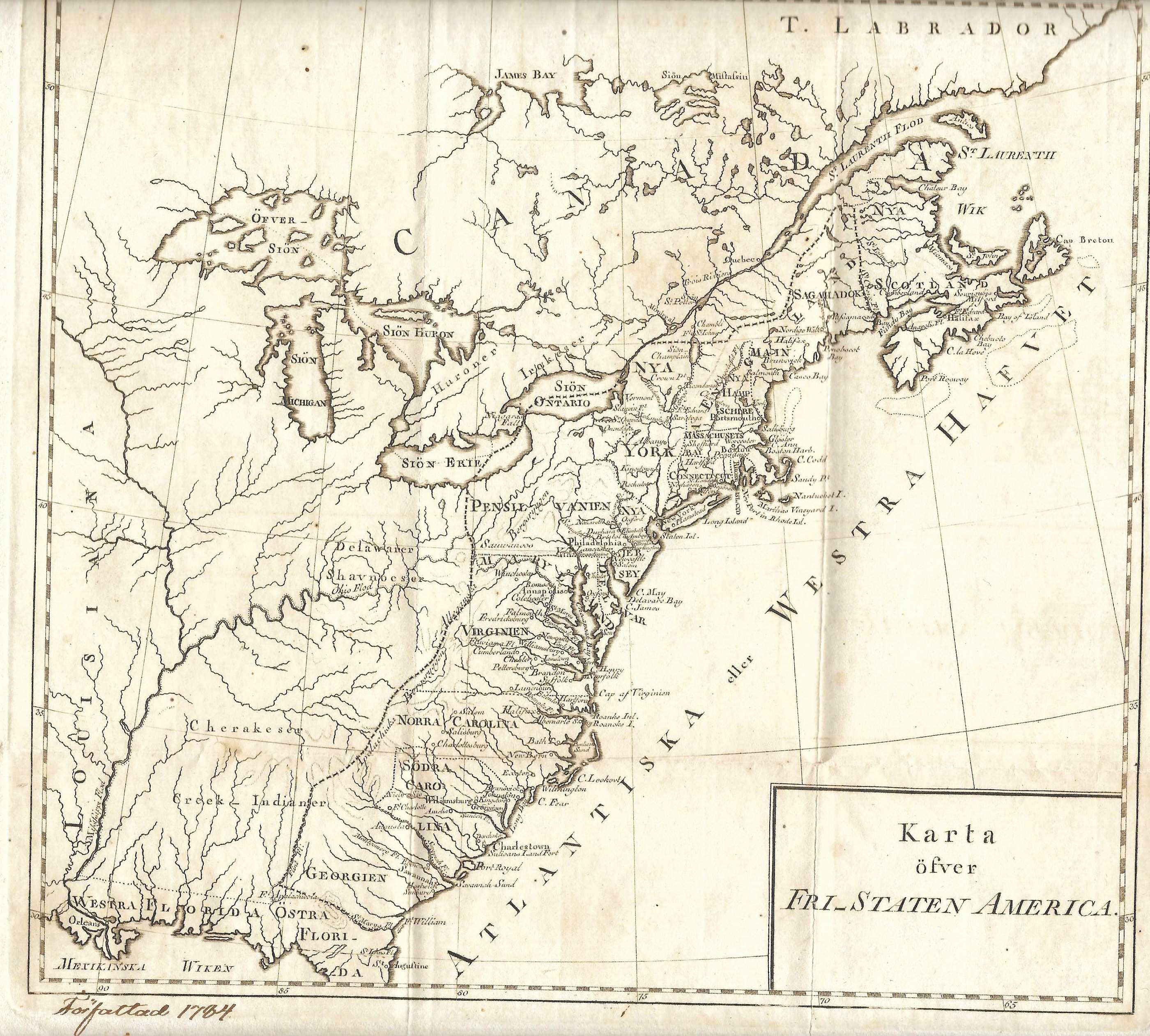
KARTA OFVER FRI_STATEN AMERICA. This is a small Swedish map apparently made shortly after the 1783 Treaty of Paris which ended the Revolution; and said to be from Carl Christoffer Gjorwell's Historiska Biblioteket. The map title translates as "Map of the Free States of America." It shows the eastern United States to the Mississippi with the 13 states identified and delineated by a dotted line; Louisiana territory and a cutoff Florida are marked as well as the Great Lakes. It is dated from a handwritten note at the bottom on the copy shown here, which seems original or close to it. Intaglio print, originally folded, blank verso. Longitude appears to be west from London. Scale: 1 inch = 206 miles. Size: 8.25 x 9 inches. |


