Lancaster County (county seat
at Lancaster) was created in 1729, the fourth county in the state.
 |
1720.1
AMPLISSIMAE REGIONIS MISSISSIPI SEU PROVINCIAE
LUDOVICIANAE..., by John Baptiste Homann (McCorkle #720.1),
this map appears in various Homann atlases. It shows the
entire eastern United States and is based upon the De l'Isle
map of 1718 with New England added. Pennsylvania is
confined to the area east of the Susquehanna. The image
here is from a later edition of the map dated circa 1763
by the Library of Congress from where this image comes. A version dated circa 1730 is at the Darlington Library.
|
| |
1720.2 A NEW
ACCURATE MAP OF THE ENGLISH PLANTATIONS IN AMERICA AND OF
THE LOUISIANA AND RIVER MISSISSIPI. London sold by R.
Dunoyer in the Strand & A. Rocayrol in St. Martins
Lane (McCorkle #720.3), from The Political State of
Great Britain, vol. 19, 1720. |
 |
1721.1 A MAP OF
LOUISIANA AND OF THE RIVER MISSISSIPPI: this map of the
Mississipi is most humbly inscribed to William Law of
Lanreston, esq. by Iohn Senex. This map is from John
Senex's A new general atlas, containing a
geographical and historical account of all the empires,
kingdoms, and other dominions of the world, 1721. 'Pensilvania'
just barely makes it onto the edge of this map of the
middle United States. It can be seen at the Hargrett
Library Rare Map Collection - Colonial America
and also at the Library
of Congress,
from where this detail of the Pennsylvania area comes. |
| |
1721.2 NIEU
ENGELAND NIEU YORK NIEU JERSEY EN PENSILVANIA DOOR H. MOL.,
from a Dutch printing of John Oldmixon's 1708 history (McCorkle
#721.1). There is also a 1744 German version (McCorkle #744.6).
|
| |
1721.3 NIEUWE
KAART VAN VIRGINIE EN MARILAND DOOR H. MOL., from the
Dutch printing of Oldmixon as the map above. Like the
1708 version, this map extends past the 40th parallel and
includes a slice of southeastern Pennsylvania. The map
can be seen in Papenfuse & Coale; and as with the map
above, there is a 1744 German version. |
| |
1722.1
A MAP OF CAROLANA AND OF THE RIVER MESCHACEBE, from A
Description of the English Province of Carolana by
Daniel Coxe, London 1722, (McCorkle #722.1, also
reproduced in Brown, No. 11, where it is dated 1726;
there were several editions). Carolana spreads from Texas
to the Appalachians in this map, one of the first English
maps of the Mississippi River valley. Coxe was the holder
of an annulled land grant to Carolana which he believed
stretched from the mountains to the Mississippi.
Pennsylvania and all the other colonies are pictured as
coastal holdings. He persisted for years trying to
establish his rights, including the making of this map,
all for nought. This map may also be seen at the
University of Virginia site Exploring
the West from Monticello: Chapter 2
. |
| |
1723 |
| |
1724.1 NOVA
ANGLIA SEPTENTRIONALI AMERICAE IMPLANTATA..., from Homann
Heirs and may have appeared earlier (McCorkle #724.1).
Only the eastern sliver of Pennsylvania makes it onto
this map and the state is not named, though Philadelphia
is named. This map is reproduced in
Portinaro & Knirsch dated
1725. |
 |
1724.2 A MAP OF
THE COUNTREY OF THE FIVE NATIONS BELONGING TO THE
PROVINCE OF NEW YORK AND OF THE LAKES NEAR WHICH THE
NATIONS OF FAR INDIANS LIVE WITH PART OF CANADA TAKEN
FROM THE MAP OF THE LOUISIANE DONE BY MR. DELISLE IN 1718.
This map appears in Brown, No. 13, dated circa 1730 and
called a manuscript map, and as the title says, is based
upon Delisle's map. It is also in Swift (2001) dated
circa 1723-26, where the original in the Public Record
Office, London, is shown. The map is dated 1724 in
Schwartz & Ehrenberg and called an engraving which it
appears to be. The region covered by New York,
Pennsylvania, and Maryland west to Lake Michigan is shown.
Rivers are indicated. The portage from Lake Erie (also
called Orswego on the map) to the Allegheny is called 'Carr.
Place'. There is no other detail. The map lists many
Indian tribes though none are named for Pennsylvania.
This map appeared in Colden's Papers Relating to an
Act of New York for Encouragement of the Indian Trade,
New York 1724. The map which appears in Colden's 1750
history is based upon it and this image is from a modern
reprint of Colden's
The History of the Five
Indian Nations of Canada, published in London 1747,
1750. |
 |
1725.1
REGNI MEXICANI NOVAE HISPANIAE LUDOVICIANAE, N. ANGLIAE,
CAROLINE, VIRGINIAE, ET PENNSYLVANIA, NECNON INSULARUM
ARCHIPELAGI MEXICANI IN AMERICA SEPTENTRIONALI ACCURATA
TABULA, by J. B. Homann. A view of southern North America
with the political divisions as dictated by the Treaty of
Utrect in 1713. This map falls outside the definition of
a Pennsylvania map used here but has the name in the
title. The state barely shows, but the chance to include
a map with both Mexico and Pennsylvania in the title can't
be missed. The bottom left section shows a naval battle
off the southwestern coast of Mexico. This map is
reproduced in Portinaro & Knirsch and dated 1725. A copy at the Darlington Library is dated circa 1737.
Image from the Heritage Map Museum CD by permission. |
| |
1726.1
A NEW MAP OF LOUISIANA AND THE RIVER MISSISSIPPI. This
anonymous map was seen at auction and attributed to
either the pamphlet Some Considerations on the French
Settling Colonies on the Mississippi (1720) or The
Memoirs and Secret Negotiations of John Ker Containing
Material on Louisiana and French Empire in America (1726),
both of which apparently contain essentially the same map
but with slightly different cartouches. However, given
its title, the map would seem to postdate the 1721 Senex
map above. The map shows much the same region as the
Senex map, i.e. the middle United States from Lake
Ontario past the Mississippi, but it is a different map
and extends further eastward. All of Pennsylvania is
shown and boundaries are drawn confining the English
colonies to the coast reflecting French opinion. |
 |
1727.1
DRNUGHT OF THE SUSQUEHANNAH RIVER, made by Isaac Taylor
Surveyor of Chester Co. A facsimile of this manuscript
map appears in Hanna dated circa 1727, which is the image
here. It appears to show the area from Harrisburg to
Sunbury, where a number of Indian villages lay. The same
map appears in a history of Dauphin County by William
Egle who dates it as early as 1701. The Juniata River is
named 'Cheniaty' and the West Branch is called 'Chimasky
or Shamokin'. The locations of two Indian traders are
shown: 'J. Letorts Store' at the West Branch fork, and 'John
Skulls Store' further south. The map would appear to
predate John Harris' ferry at Harrisburg. |
| |
1728.1 THE
ENGLISH EMPIRE IN AMERICA BY R B, from a reprint of the
1685 edition of Nathaniel Crouch's book of the same name
(McCorkle #728.1). |
| |
1728.2 A CHART OF
THE ATLANTICK OCEAN FROM BUTTONS ISLAND TO PORT ROYALL,
by Nathaniel Cutler & Edmund Halley, London 1728.
This map shows the east coast from Labrador to Carolina.
A large inset map of the Chesapeake and Delaware Bay area
names 'Pensilvania.' The map is from Atlas Maritimus
et Commercialis, published in London in 1728 as a
competitor to the English Pilot. The map is #728.2
in McCorkle, where John Senex is identified as the
possible maker. Edmund Halley is otherwise famous for the
comet named after him, and for cajoling Isaac Newton into
writing the Principia, which Halley published at
his own expense. |
| |
1729.1 NOUVELLE
HOLLANDE, (A PRESENT NOUVELLE-YORK) NOUVELLE-ANGLETERRE,
IT UNE DE LA VIRGINIE..., by Peter van der Aa, from Galerie
agreable du monde, vol. 64, Leiden 1729 (McCorkle #729.1).
This is another Jansson-Visscher map with a somewhat
different title. |
 |
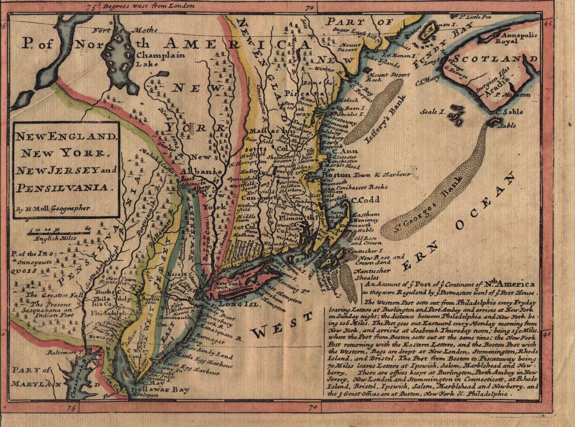
1729.2 NEW
ENGLAND, NEW YORK, NEW JERSEY AND PENSILVANIA. by H. Moll
geographer, from Moll's Atlas Minor 1729 (McCorkle
#729.2). This is called the 'Post Road' map because at
bottom right it says "An Account of ye Post of ye
Continent of Nth. America...," and it shows the
coastal road from north of Boston to Philadelphia. It is
larger and differs somewhat from Moll's 1708 map of
similar title though the area covered is the same. This
map appeared in editions of the Atlas Minor and
English histories and McCorkle illustrates several
versions. Longitude west from London, blank verso. Scale:
1 inch = 50 miles. Size: 8 x 10.75 inches. |
 |
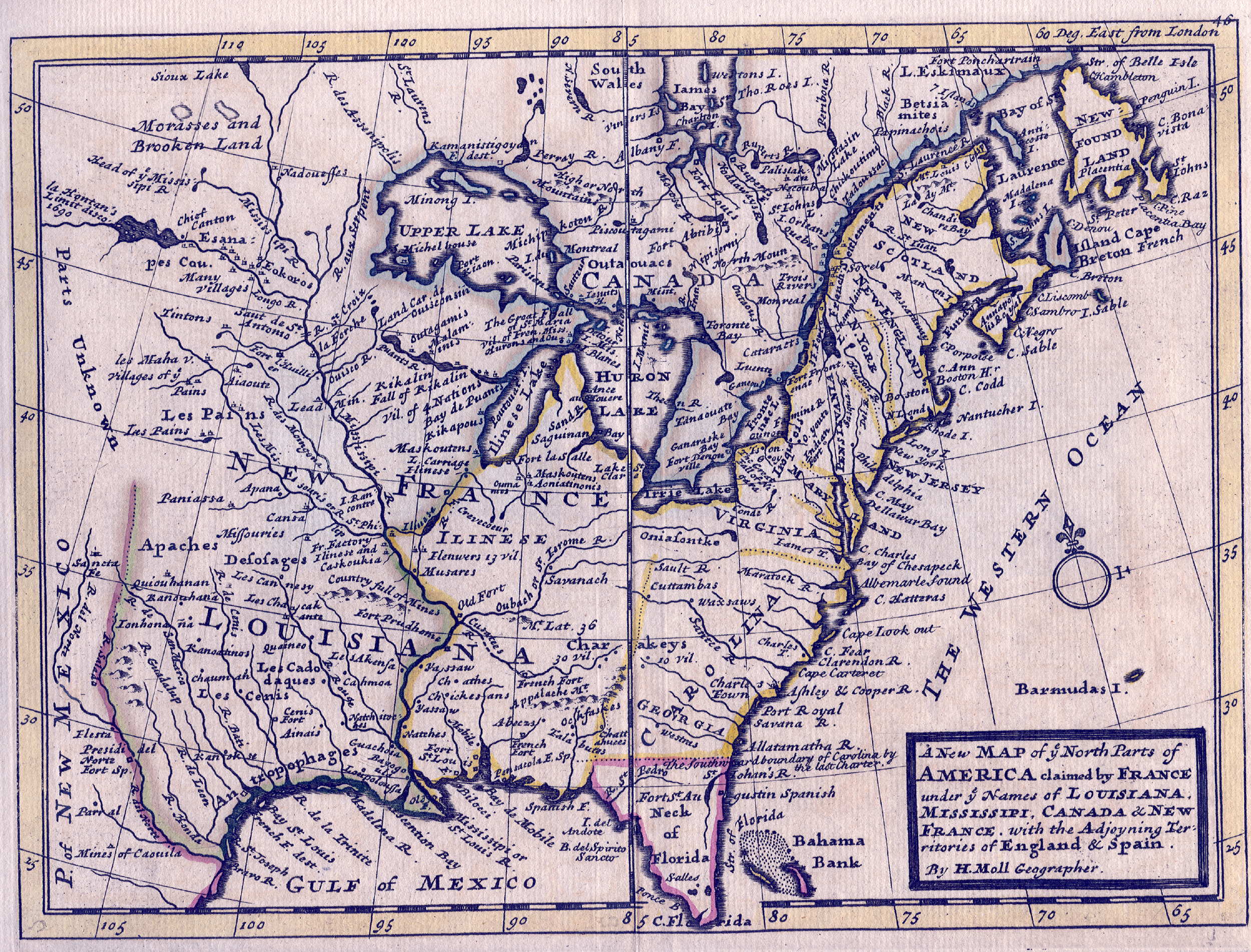
1729.3 A NEW MAP
OF YE NORTH PARTS OF AMERICA CLAIMED BY FRANCE UNDER YE
NAMES OF LOUISIANA, MISSISSIPI, CANADA & NEW FRANCE,
WITH THE ADJOINING TERRITORIES OF ENGLAND & SPAIN. by
H. Moll geographer. 1729. This map (McCorkle #729.3) is
from Moll's Atlas Minor and is a reduced version
of a world map he published in 1720. There were many
subsequent editions of the Atlas and the image
here is a circa 1730's version that lacks the date but is
otherwise identical. The map is colored to show who
controls what; the Spanish own Florida and the southwest,
the French part of Canada and Louisiana, the English the
eastern United States to the Mississippi. All the
colonies are shifted too far north, Pennsylvania lies
alongside Lake Ontario. There is a curious defect in the
longitude marking which says "east from London"
when in fact it is west. Blank verso. Scale: 1 inch = 275
miles. Size: 8 x 10.75 inches. |
| |
1729.4 VIRGINIE,
GRANDE REGION DEL 'AMERIQUE SEPTENTRIONALE..., published
in La Galerie Agreable du Monde..., A Liede,
Pierre Vander Aa, 1729 Vol. 63-64. This map is called
state 2 by Verner (in Chapter 4 of Tooley) of the
Montanus/Ogilby derivative 8 of John Smith's map of
Virginia. The coverage extends north to 41 degrees and so
includes a slice of southern Pennsylvania. The state 1
titles and cartouches were removed, the map retitled and
some additional place names added. The Dutchman van der
Aa was based in Leiden and apparently all (or most) of
his atlases were made from outdated plates acquired from
other and better cartographers. This map is #229A5 in the
Maryland Archives. |