


| WELCOME | 1750 to 1754 Pennsylvania Maps | WELCOME |
After 1750 a new world of American map-making opens; the French and Indian War and the subsequent American Revolution brought an avalanche of maps. The year 1755 has been called the 'year of the map,' and the most famous pre-Revolutionary maps of America (from the English point of view) were published in 1755, the maps of Lewis Evans and John Mitchell; both are reproduced side by side in Schwartz & Ehrenberg, and can be found in most map histories. A long list of the reissues and pirated copies of Evans' map is given by Stevens & Tree in Tooley, Chapter 2. The Evans map in 1755 and 1771 versions can be seen at MAGIC-lib.uconn.edu . Additional maps by D'Anville, Huske, Herbert & Sayer, and Bellin were published the same year and reproductions are given in Schwartz (2000). The Mitchell, D'Anville and other maps depicted eastern North America from Newfoundland to Florida and west to beyond the Mississippi, and in the ensuing years many maps were published with this geography.
In addition to engraved published maps, a large number of manuscript maps of the Ohio valley region were made during the decade. Some describe the adventures of George Washington (1753-54), and the armies of General Edward Braddock (1755) and General John Forbes (1758) in western Pennsylvania. Discussions and reproductions of many of these maps are given by Brown, Myers, and Schwartz (1994). Photographs of manuscript maps of America held by the British Library were gathered and published by Hulbert (1907), several of which pertain to the French & Indian War era. Several manuscript plans of forts exist from this era; most include enough topography to be called maps, but others do not. A history of the western frontier forts reproducing most of the extant manuscript plans is given by Stotz.
Cumberland County with the county seat at Shippensburg and later Carlisle was created in 1750. Berks County with the county seat at Reading, and Northhampton County with the county seat at Easton, were created in 1751/1752. There were now eight counties.
|
1750.1 MAPA DE UNA PARTE DE LA AMERICA SEPTENTRIONAL PARA SERBIR A LA INTELLIGENCIA DEL RAQUERDO..., a Spanish manuscript map showing the east coast from Virginia to Labrador. This image is a detail showing only the Pennsylvania region, the complete map can be seen at the Library of Congress site. The map was probably made in 1750 or 1751 per the note 'Los limites propuestos dentro las memorias de los Señores Commissarios Inglezes del 21 Septbre. 1750, y Enero 1751 ... .' The prime meridian of Paris is used, so it likely derives from French maps. There seem to be few Spanish or Italian maps showing English colonial America, or maybe the ones that exist are just not well known. |
|
1750.2 CARTE DE LA LOUISIANE..., Par le Sr. Bellin Ingr. ordre. de la Marine. 1750. (McCorkle #750.1, 755.3; Sellers & van Ee #74, 75, 90, 91) This map shows the eastern United States west to beyond the Mississippi. It appeared in Remarques sur la carte de l'Amerique Septentrionale published in 1755 and possibly as a separate sheet. This image is from the Library of Congress. |
|
1750.3 A MAP OF THE BRITISH EMPIRE IN AMERICA FROM THE HEAD OF HUDSON'S BAY TO THE SOUTHERN BOUNDS OF GEORGIA, WITH THE INTERVENTION OF CANADA, published pursuant to Act of Parliament Novr. 1750. for Owen's Magazine of Magazines (McCorkle #750.3) . The title is in a strip across the top and the attribution at the bottom is missing from the copy shown here. The map shows the northeast from Newfoundland to Carolina and west to just beyond Lake Erie. Philadelphia, Bucks, and Canoogo are named, as well as Indian tribes. The boundary line for Pennsylvania does not include Delaware (given to Maryland) and extends only just past the Susquehanna with a mysterious lake to the west. Numerous Indian tribes are named and a couple more mystery lakes shown in the south. Blank verso, longitude from London. Scale: 1 inch = 150 miles. Size: 9.5 x 11.5 inches. |
|
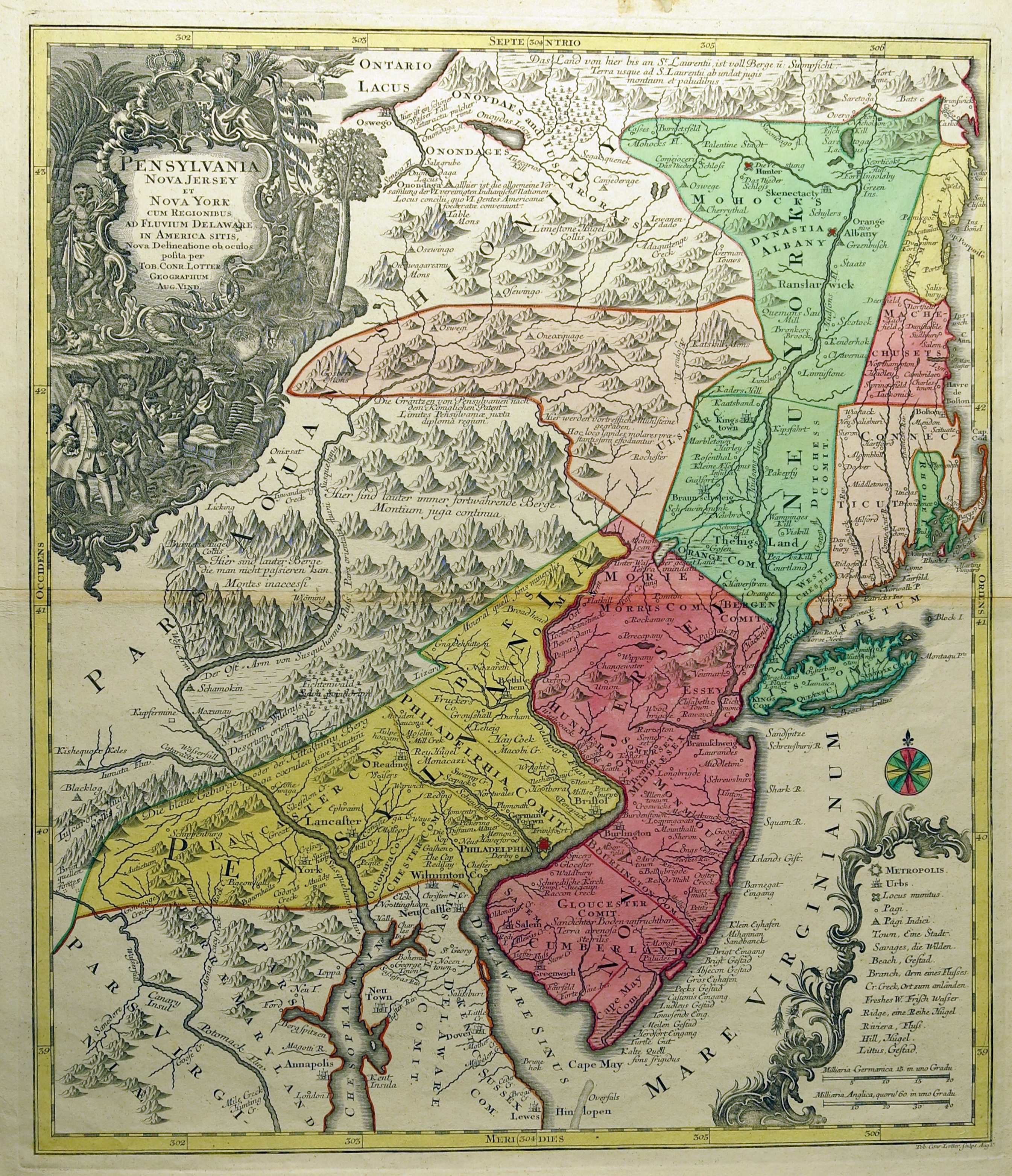
1750.4 PENSYLVANIA NOVA JERSEY ET NOVA YORK CUM REGIONIBUS AS FLUVIUM DELAWARE IN AMERICA SITIS, per Matth. Seutterum S.C.A. geogr. Aug. Vind.. Tob. Conr. Lotter sculps. Aug. V. This map appeared in several Seutter and Lotter atlases with Lotter's name alone in later editions (he was Seutter's son-in-law), such as the copy shown here. The map includes most of New York and Maryland and extends west to just beyond the Susquehanna. Much of the detail is from the Lewis Evans map of 1749 so the first Seutter version is usually dated circa 1750, see Docktor (1993) for a discussion on the states and dating of this map. Seutter died in 1756 when Lotter took over his business, and Lotter died in 1777; so this copy of the map with only Lotter's name was probably issued between these dates. The differences between the versions are minor, Jersey spelled with an "I" instead of a "J" for example. Blank verso, longitude east from Ferro. Scale:1 inch = 16 miles. Size:22.25 x 19 inches. |
| 1750.5 REISE CHARTE DURCH PENSYLVANIEN UND ANDRE ANGRANJCNDE PROVINGIEN..., a manuscript map online at the Bethlehem Digital History Project and dated circa 1750-55. The full title in English is "TRAVEL MAP through Pennsylvania and other Bordering Provinces, with Notation of all the Estates Living Places, and Churches, and Schoolhouses of the Unified Brethren, known as the UNITAS FRATRUM also some individual families connected to them, as well as various Inns and Roadways." It shows southeastern Pennsylvania. | |
| 1750.6 (Middle Atlantic states showing rivers and mountains and location of sea shells on the tops of the mountains). This manuscript map was found listed under #32 in the map archives of the American Philosophical Society attributed to John Bartram and dated to the 1750s. The Society provides the following description: "As early as 1741, John Bartram sent some fossil sea shells to Sir Hans Sloan; other shells were sent to his London friend Peter Collinson in 1742. He wrote to Collinson in 1743 or 1744 that he had observed such fossils everywhere, 'even on the top of the mountain that separates the waters of Susquehanna and St. Lawrence.' (William Darlington, Memorials of John Bartram and Humphry Marshall [Philadelphia: 1849], p. 169.) Bartram was used to making rough maps of his travels and he made no pretense of being a competent surveyor. He apologized to Collinson for a map which he said was 'Clumsily done, having neither proper instruments nor convenient time,' since he was drawing by the early light of dawn or by candlelight. Franklin wrote his friend Jared Eliot on 16 July 1747 of Bartram's discoveries: The great Apalachian Mountains, which run from York [Hudson] River back of these Colonies to the Bay of Mexico, show in many Places near the highest Parts of them, Strata Sea Shells, in some Places the marks of them are in the solid Rocks. 'Tis certainly the Wreck of a World we live on! We have Specimens of those Sea shell Rocks broken off near the Tops of those Mountains, brought and deposited in our Library [the Library Company of Philadelphia] as Curiosities. If you have not seen the like, I'll send you a Piece. (The Papers of Benjamin Franklin [New Haven: Yale University Press: 1961], vol. 3, p. 169.) The endorsement on the back reads, in Franklin's hand: 'Mr. Bartram's Map very curious.' " An image of the map is provided at the Society's website. It shows the Chesapeake and Delaware Bay area back to the mountains and is crudely drawn. A general catalog of maps in the American Philosophical Society collections is given by Smith, M. D. | |
|
1751.1 A MAP OF THE MOST INHABITED PART OF VIRGINIA, CONTAINING THE WHOLE PROVINCE OF MARYLAND WITH PART OF PENSILVANIA, NEW JERSEY AND NORTH CAROLINA, by Joshua Fry and Peter Jefferson. Peter Jefferson was Thomas's father. The image here is from a Library of Congress copy dated 1755. Although an important map for Virginia history, this one was rather quickly superseded by the Evans and Mitchell maps of 1755 and by the events of the French and Indian war. This map is best known from the updated version that appeared in Faden's The North American Atlas in 1777, and that version is reproduced in Fite & Freeman #61. The original is reproduced in Schwartz & Ehrenberg. Southern Pennsylvania is largely a blank in the original, but is shown in some detail north to the Forks of the Ohio in the 1777 version. A 1755 version is reproduced in Stephenson & McKee and the map can be seen at the University of Virginia site Exploring the West from Monticello: Chapter 3 , where it is dated 1754. Stevens and Tree (Chapter 2 in Tooley) list about seven versions; Pritchard & Taliaferro #30 list eight versions and provide a discussion of the map. Versions dated circa 1755 and 1775 can be seen at the Darlington Library. A circa 1755 French version by de Vaugondy is titled CARTE DE LA VIRGINIE ET DU MARYLAND, and can also be seen at the Darlington. |
|
1752.1 A MAP OF PHILADELPHIA AND PARTS ADJACENT WITH A PERSPECTIVE VIEW OF THE STATE HOUSE, by N. Scull and G. Heap. This map contains the first known image of Independence Hall, then called the Pennsylvania State House, shown in this close up . The early maps of Philadelphia are a subject all their own and usually considered separate from maps of Pennsylvania, see for example Wheat & Brun, where this map is No. 454. Most Pennsylvanians also consider Philadelphia a separate entity, rather the way Marylanders look upon the District of Columbia, and New Yorkers look upon New York City. This image is from a copy in the Library of Congress, Wheat & Brun #454-55. Reduced versions appeared in the Gentleman's Magazine,1753 and 1777, as listed by Sellers & van Ee #1306-7; and in Faden's North American Atlas, Sellers & van Ee #1319-21. M. P. Snyder, Figures 11-16, illustrates versions of this map as well as Heap's views of Philadelphia. |
| 1752.2 KARTE VON CANADA VON HERRN CL LE BEAU HERAUSGEGEBEN Im: Eben sc: Francofurti ad Moenum (McCorkle #752.1). This is a German copy of map 1738.1 by Claude Le Beau, there was also a 1756 version. McCorkle shows a comparison of all three. | |
| 1752.3 CARTE MINERALOGIQUE, OU L'ON VOIT LA NATURE DES TERRIENS DU CANADA ET DE LA LOUISIANE. Dressee par Philippe Buache..., de Mr. Guettard de la meme Acade. 1752. Desbruslins fils sculps (McCorkle #752.2). This is one of the earliest geological thematic maps of North America, shown west to beyond the Mississippi with an inset of the St. Lawrence River. A long table of symbols (Explicauon des Caracteres) on the right side includes Charbon de Terre, Granit, Marbre, Petrole, etc. No symbols appear in present day Pennsylvania. The map appears in Mémoire dans lequel on compare le Canada à la Suisse par rapport à ses minéraux, from Suite des Memoires de Mathematique et de Physique, Tires des Registres De L'Academie Royale des Sciences De L'Annee M.D CCLII. Jean-Etienne Guettard was a French scientist who also prepared some of the earliest mineralogical maps of France in the 1740s. He visited America circa 1750. There was a second printing of his memoire by Schreuder and Mortier Amsterdam 1761. | |
|
1752.4 A MAP OF THE OHIO COUNTRY showing the places in Canada west of Niagara visited by John Patten during his captivity by the French, 1750-1751. This is a manuscript map held by the Library of Congress and described in Brown #16, who gives it this title. Patten was an Indian trader and one of the first to get to know the Ohio country. His map covers the course of the Allegheny and Ohio Rivers from Pennsylvania into Indiana, and has the first map note on "Sea Coal." This map is discussed in great detail by Eavenson. |
|
1752.5 A NEW & ACCURATE MAP OF LOUISIANA, WITH PART OF FLORIDA AND CANADA, AND THE ADJACENT COUNTRIES. Drawn from surveys, assisted by the most approved English & French maps & charts, the whole being regulated by astronl. observations. By Eman. Bowen, London, 1752. This map shows the region from Maine to Florida and west to the Rockies. Bowen has Canada extending down into Pennsylvania. Philadelphia is named and a few Indian villages. This image is from the Library of Congress. |
| 1752.6 PART OF THE OHIO RIVER, SHOWING THE FALLS. This title is given to a manuscript map facsimile in the Darlington Library dated circa 1752. It also has the title 'Part of the Ohio River, showing the falls, the Great Conhaway alias Wood's alias New River, Monongaly River, Shurtees Creek, Fort Du Quesne, part of Lake Erie, etc. and the courses of Christopher Gist's first and second tours;' and is also called 'Map of Christopher Gist's first and second tours.' The original is in the Public Record Office (or National Archives), London, in Board of Trade Maps Vol. 12, No. 6. It shows Gist's record of his travels into the Pittsburgh region and the Ohio country. | |
|
1752.7 NORTH AMERICA. Performed under the patronage of Louis Duke of Orleans, First Prince of the Blood; by the Sieur D'Anville. Greatly Improved by Mr. Bolton. Engrav'd by R.W. Seale. MDCCLII. Gravelot Delin. Walker Sculp. Printed for John and Paul Knapton. This is an English version of an earlier French map and probably based on several of the 1740's maps. It shows the eastern United States in some detail and is an earlier version of the circa 1754 maps published by Henry Overton and described below. According to a listing in COPAC, this map is from the Universal Dictionary of Trade and Commerce, published in London by Malachy Postlethwayt, printed for John and Paul Knapton, 1752. This was a serial English printing of Dictionnaire Universel de Commerce by J. Savary des Bruslons, which appeared from 1751-55. There was apparently a second edition circa 1766. This map is the top right sheet only of a four sheet map of North America covering the continent from James Bay south to about 15 degrees latitude. This sheet shows the eastern United States from Newfoundland to a cutoff Florida and west to beyond the Mississippi. It shows towns, boundaries, rivers, pictorial relief; no roads. The map has extensive notes (some shown here) on treaties, territorial rights, etc.; the note on the history of the map at bottom is especially interesting. COPAC lists what is apparently an earlier (and probably one sheet) version of this map as "A map of North America, by d'Anville, improved by Bolton, and engraved by Seale" issued in 1750 and 1752. Blank verso; longitude west from Ferro. Scale: 1 inch = 100 miles. Sheet size: 18 x 22 inches. |
|
1753.1 MERCER'S MAP. An untitled manuscript map of the Ohio Company's lands on the Ohio River with proposed location of fort and settlement, signed G. Mercer. Virginia claimed the Ohio country, so called, and a joint stock company called the Ohio Company was formed in Virginia to exploit the region. Ignoring the Forks of the Ohio, Mercer proposes building a fort downstream along the Ohio River near the present day town of McKees Rocks. This location was in fact considered when it came time to build Fort Pitt around 1760. This map is important because it is one of the earliest local maps of the Pittsburgh region. This black & white image is from a reproduction in Hanna. The map is reproduced in Schwartz (1994), in Brown No. 17, and in Hulbert(1907). |
|
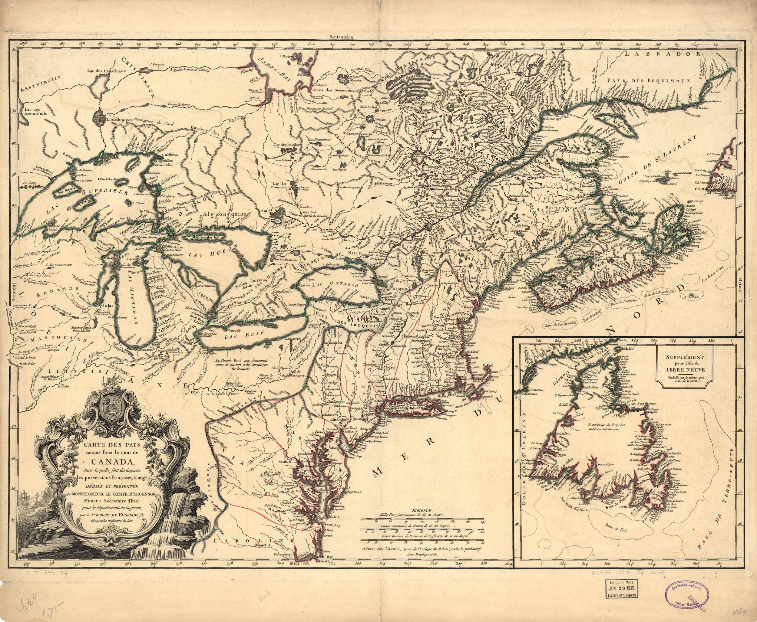
1753.2 CARTE DES PAYS CONNUS SOUS LE NOM DE CANADA, DANS LAQUELLE SONT DISTINGUEES LES POSSESSIONS FRANCOISES, & ANGL..., par le Sr. Robert de Vaugondy fils geographe ordinaire du Roi (McCorkle #753.1, #755.35; Sellers & van Ee #15). A map of the northeast from the St. Lawrence to the Chesapeake and west to include the Great Lakes. There were several states, the 1778 one (map 1778.10), CARTE DU CANADA ET DES ETATS-UNIS DE L'AMERIQUE SEPTENTRIONALE..., is one of the first maps to name the United States (Etats-Unis) in the title. McCorkle shows both versions. This image is from the Library of Congress. |
|
1753.3 A MAP OF THE WESTERN PARTS OF THE PROVINCE OF PENNSYLVANIA, VIRGINIA, &C. This is a manuscript map from the Library of Congress dated circa 1753. It has the inscription "To the Honourable House of Representatives of the Province of Pennsylvania this map is most humbly inscribed by their most obedient and humble servant." This map is included only because Pennsylvania is in the title. The map shows the area from the Wabash River on the west to the Scioto River on the east, and from Lake Huron on the north to the Green River in Kentucky on the south and does not include the modern state. While not an exact copy, there is similarity to the western part of the "Traders map" ascribed to John Patten, map 1752.4. |
|
1753.4 AN EAST PROSPECT OF THE CITY OF PHILADELPHIA, taken by George Heap from the Jersey Shore, under the direction of Nicholas Scull, Surveyor General of the Province of Pennsylvania. This famous view of Philadelphia also contains a map of the city's grid of streets titled A PLAN OF THE CITY OF PHILADELPHIA. This map is reproduced in Swift (2001) dated circa 1755. The image here is from Jeffrey's A general topography of North America and the West Indies published in 1768, from the Library of Congress. Heap's original view did not contain the map and was prepared circa 1752 and printed circa 1754. The view containing the map came later and M. P. Snyder dates it 1756. Both versions are shown in Snyder, Figures 17, 18. |
|
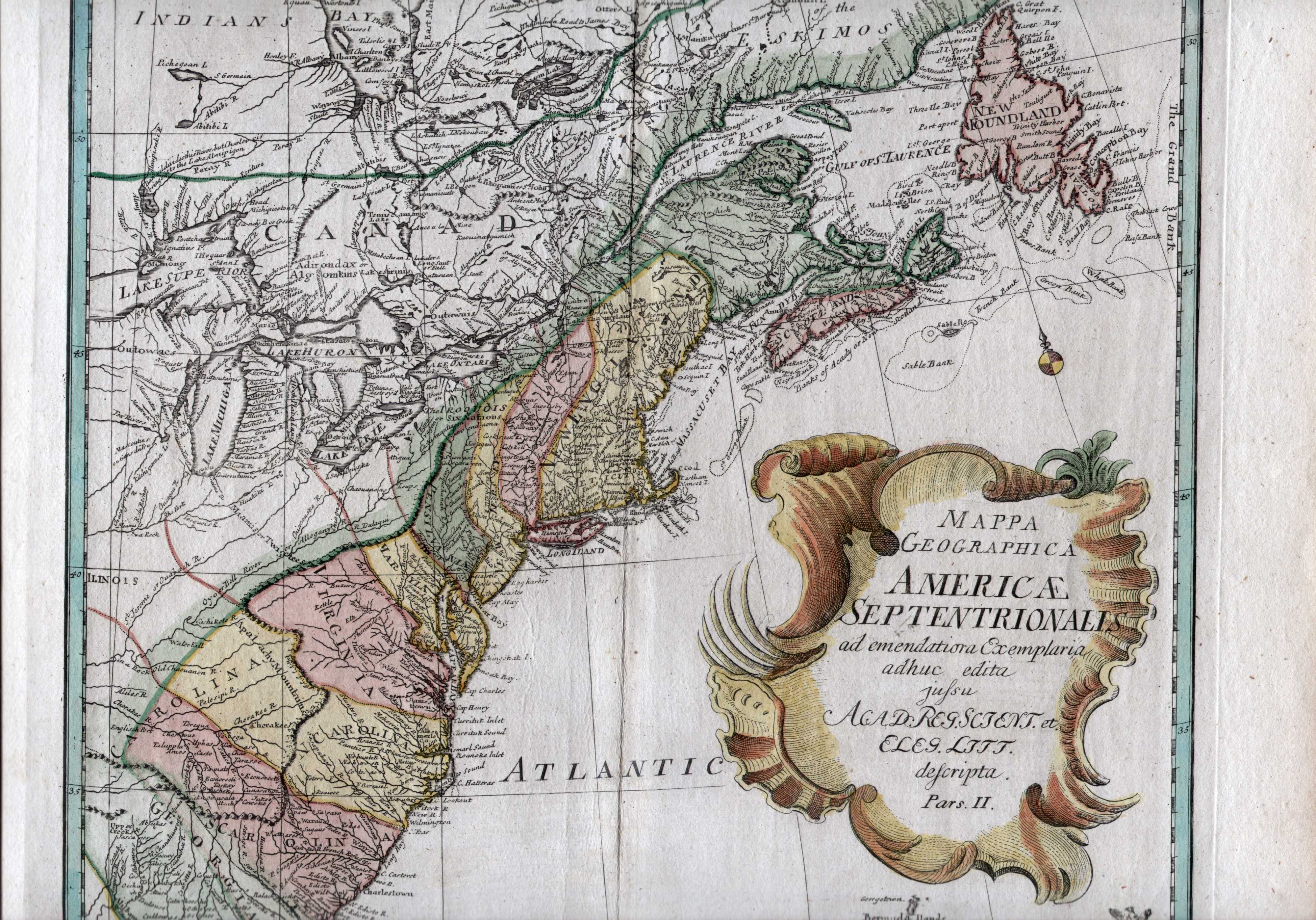
1753.5 MAPPA GEOGRAPHICA AMERICAE SEPTENTRIONALIS ad emendatiora exemplaria adhuc edita jussu Acad. Reg. Scient. et. Eleg. Litt. descripta. Pars II. McCorkle (#775.4) says the date of this four-sheet map of North America is conjectural, and dates it 1775 and ascribes it to Leonhard Euler. However, it is believed to come from Atlas Geographique omnes orbis terrarum regiones... by Leonhard Euler, published for the Royal Prussian Academy of Sciences , Berlin 1753. The northeast sheet was printed to be issued separately and so is included here. It shows the region from Newfoundland to Florida and west to include the Great Lakes. The colonies are given elongated north-south boundaries as on Overton's 1754 map. Longitude apparently east from Ferro, blank verso. Scale: 1 inch = 118 miles. Size: 13.5 x 14 inches. |
|
1754.1 A MAP OF THE WESTERN PARTS OF THE COLONY OF VIRGINIA, J. Gibson Sculpt. printed for R. Baldwin, in Pater Noster row for the London Magazine 1754. This map is a portion of a larger map by Jeffreys with the same title, see Schwartz (1994). Virginia at this time claimed much of western Pennsylvania as this map shows. It has a fancy engraving on tobacco growing at lower right. A road is shown from Williamsburg to Winchester to Gist's Settlement to Shanopin's T. to Logstown on the Ohio to Vinango on the Allegheny to Fr. Fort on Lake Erie. This route was traveled by George Washington in his negotiations with the French in 1753/54 prior to the French and Indian War. The Fr. Fort was built to control the portage route from the lake into the Ohio River basin via the Allegheny River. These 'magazine maps' started appearing in London publications in mid-century. This map accompanied the article Some Extracts from the Journal of Major George Washington, refering to Washington's report to Governor Dinwiddie published in pamphlet in Williamsburg early in 1754. Listed in Phillips page 981. Longitude is given west from Ferro. Blank verso. Scale: 1 inch = 100 miles. Size: 8 x 5.5 inches. |
|
1754.2 A MAP OF THE BRITISH AMERICAN PLANTATIONS, EXTENDING FROM BOSTON IN NEW ENGLAND TO GEORGIA; INCLUDING ALL THE BACK SETTLEMENTS IN THE RESPECTIVE PROVINCES, AS FAR AS THE MISSISSIPI. By Eman:Bowen geogr: to His Majesty, Gent. Mag: July 1754 Thos. Bowen sc. A map from the Gentleman's Magazine covering the region described (McCorkle #754.1; Sellers & van Ee #708). This map was possibly copied from the Overton map below (or vice versa) as it has the same elongated north-south boundaries for the colonies. There were at least two different printings, this image from the Library of Congress shows a hatched trail from Lake Erie south to the "French Fort" where it splits with trails west and following the Allegheny and Ohio Rivers. Another copy of this same map does not have these trails. Longitude west from Ferro, blank verso. Scale: 1 inch = 100 miles. Size: 8.5 x 11 inches. |
|
1754.3 AN ACCURATE MAP OF THE ENGLISH COLONIES IN NORTH AMERICA BORDERING ON THE RIVER OHIO (McCorkle #754.2). An undated map published by Henry Overton as a broadside with text. It shows the northeast from Maine to Carolina and west to include the Great Lakes. Despite the title, the Ohio is not prominent. The colonies are given strange elongated north-south boundaries with New Jersey extending into New York and Pennsylvania; and Maryland extending into western Pennsylvania. Philadelphia and Chester are named along with several Indian villages along the Susquehanna. This image is from the Library of Congress, where a detailed image can be seen. |
|
1754.4 AN ACCURATE MAP OF THE ENGLISH COLONIES IN NORTH AMERICA BORDERING ON THE RIVER OHIO. This map is a reduced version of the map of the same title above, and was published by Overton in the Universal Magazine of December 1754. The larger map has been truncated to show the region between 35 and 45 degrees latitude. It shows New England, New York, New Jersey, Pennsylvania, Maryland, Virginia and North Carolina, and the Great Lakes as far as Lake Michigan. The peculiar elongated north-south boundaries are still there. Indian tribes, rivers, mountain ranges and coastal islands are included. Blank verso, longitude may be from Ferro as the 60 degree line goes through Pennsylvania. (McCorkle #754.3; Sellers & van Ee #707). Scale: 1 inch = 100 miles. Size: 8 x 10 inches. |
|
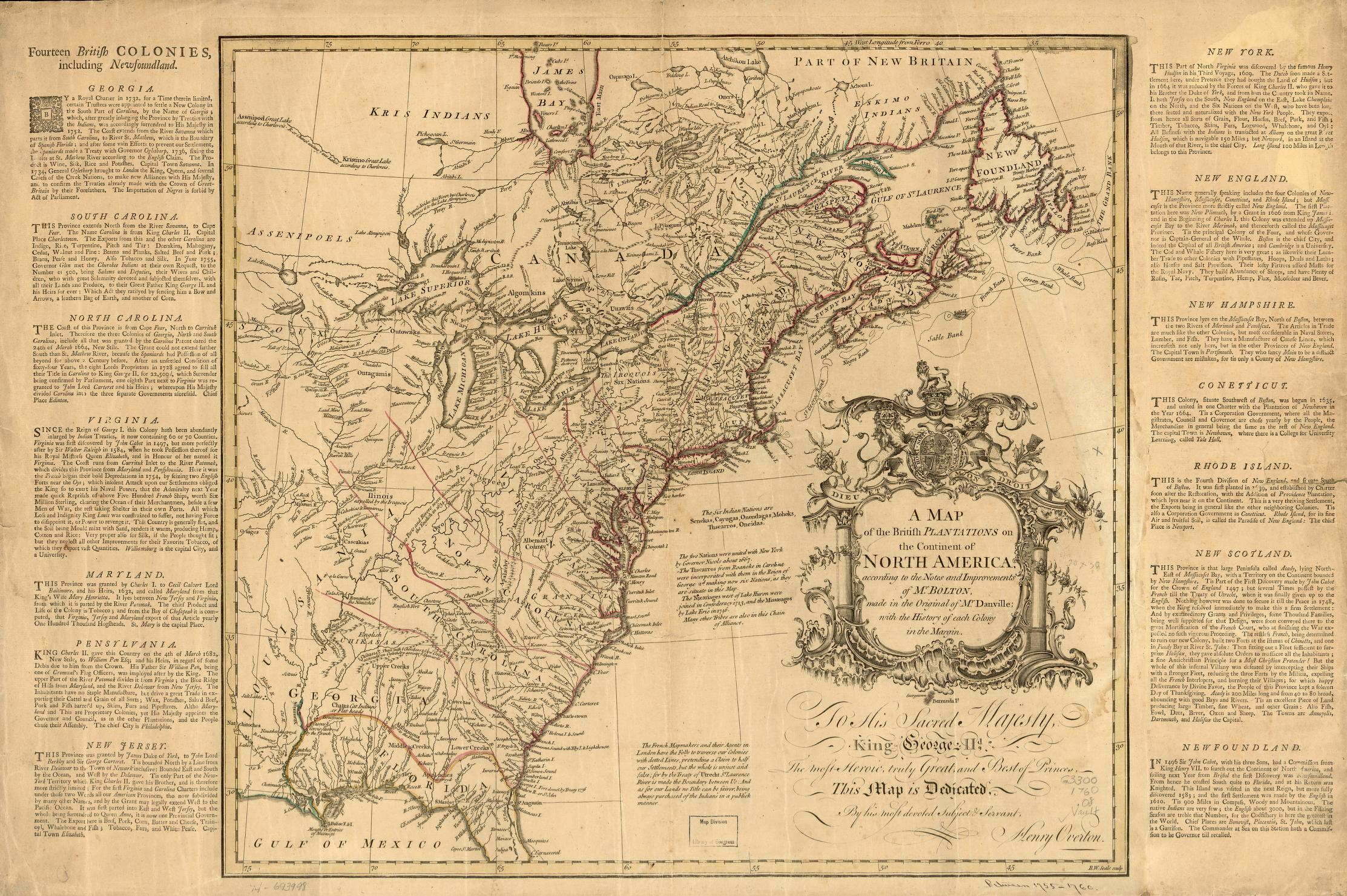
1754.5 A MAP OF THE BRITISH PLANTATIONS ON THE CONTINENT OF NORTH AMERICA, according to the notes and improvements of Mr. Bolton, made in the original of Mr. Danville; with the history of each colony in the margin. To His Sacred Majesty, King George IId., the most heroic, truly great and best of princes, this map is dedicated, by his most devoted subject & servant, Henry Overton. R. W. Seale, sculp. This is a later edition of the 1752 Bolton map above. The image here is from the Library of Congress where a more detailed image can be seen. The LOC dates this map London? 1755-1760, however a slightly earlier date similar to the Overton maps above seems likely. |
|
1754.6 CAPTAIN SNOW'S SCETCH OF THE COUNTRY BY HIMSELF, AND THE BEST ACCOUNTS HE COULD RECEIVE FROM THE INDIAN TRADERS. 1754. This is a manuscript map of western Pennsylvania with parts of Maryland and Virginia. The Library of Congress, from where this image comes, also has the manuscript draft of this more polished map; both are illustrated in Brown #20-21. Sellers & van Ee #1301-2. |
|
1754.7 (Western Pennsylvania) This is an untitled manuscript map prepared by George Washington to illustrate his journey of 1753-54 to negotiate with the French. It is illustrated in Brown #18 and Johnson (1974) and shows the river system around Pittsburgh and the trace of Washington's travels. This image is a facsimile from the Library of Congress, the original is in the Public Record Office, London. There is another manuscript map very similar to this illustrated in Schwartz (1994) and said to be in a private collection. Also, the British Library has a similar manuscript map as listed by Docktor #25_A4.01. So apparently Washington, or somebody, made more than one copy of this sketch, see map #1755.30 also. |
|
1754.8 MAP OF THE WESTERN PARTS OF THE COLONY OF VIRGINIA, AS FAR AS THE MISSISSIPI. This map appeared in The Journal of Major George Washington..., published in Williamsburg in 1754 (without the map), and the same year in London by Thomas Jeffreys (with the map). It depicts the region from the Susquehanna River to the Mississippi, and from the Great Lakes to North Carolina. In the 1750's Virginians considered this entire region to be part of Virginia. A line shows Washington's travels from Williamsburg to Lake Erie. Most of the map is blank, but the river systems are shown with some care. It is illustrated in Brown #19 and in Johnson (1974). A modern printing of Washington's journal is on line at Historic Pittsburgh. This image is a facsimile from a circa 1860's printing. |
| 1754.9 PART OF OHIO SHOWING THE FALLS. A manuscript map by Christopher Gist illustrated in Hayes (Map 108) who gives it this title. It is drawn on animal hide and dates circa 1754 as the new Fort Duquesne is shown at the Forks of the Ohio. The original is in the British National Archives. |
| 1700's | 1710's | 1720's | 1730's | 1740's | |||||
| 1750-54 | 1755-59 | 1760-64 | 1765-69 | 1770-74 | 1775-79 | 1780-84 | 1785-89 | 1790-94 | 1795-99 |
| Home Page | 16th Century Maps | 17th Century Maps | 18th Century Maps | 19th Century Maps | 20th Century Maps | References |