 |
1795.1
PENNSYLVANIA, from The United States Gazetteer by
Joseph Scott , published by F. & R. Bailey,
Philadelphia 1795, and arguably the first collection of
state maps published in the United States. This map is
listed on page 679 of Phillips and is No. 444 in Wheat
& Brun who say it was also published in Scott's An
Atlas of the United States. The Gazetteer contained
19 maps: a United States map (McCorkle #795.13, Wheat
& Brun #125), maps of the Northwest (north of the
Ohio) and Southwest (south of the Ohio) Territories, and
16 state maps including this one. County names are
present, but not county boundaries and the map can be
dated 1795-96 by the counties named. Rivers, mountains
and towns are shown but not roads, and it uses the
meridian of Philadelphia. Blank verso. Scale: 1 inch = 45
miles. Size 7 x 9 inches. |
 |
1795.2 A MAP OF
THE UNITED STATES, This map of the eastern United States
is also from The United States Gazetteer by Joseph
Scott. Scott's gazetteer was published again in 1799 with
the same maps under a somewhat different title: The
New and Universal Gazetteer; or, Modern Geographical
Dictionary. |
 |
1795.3 THE STATE
OF PENNSYLVANIA REDUCED WITH PERMISSION FROM READING
HOWELL'S MAP by Samuel Lewis. Smither - Sculp. Engraved
for Carey's American edition of Guthrie's Geography
Improved. This is one of the earliest copies of the 1792
Howell map. Wheat & Brun (No. 442) date it 1795;
Phillips, page 679, dates it 1796; it can be dated 1789-95
by counties shown. This map was published by Mathew Carey,
Philadelphia, in several other publications including: The
General Atlas for Carey's Edition of Guthrie's Geography
Improved 1796 No. 33; Carey's General Atlas,
Philadelphia 1796, Map 33; and Carey's American Atlas,
Philadelphia 1796, No. 10. A varient of this map dated
circa 1796 is listed in Wheat & Brun #448. The Scott
and Carey atlases from which maps 1795.1,2,3 come vie for
the title of "first atlas published of the United
States."Longitude west from London at top, from
Philadelphia at bottom. Blank verso. Scale: 1 inch = 18
miles. Size: 18 x 26 inches. |
 |
1795.4 A CORRECT
CHART OF THE EAST COAST OF NORTH AMERICA engraved for
Malham's Naval Gazetteer. London, Published Sepr. 19th
1795, by Allen & West, Pater-Noster Row. The coast is
shown from Labrador to Florida, Pennsylvania and
Philadelphia are named and nothing else; the inland is a
blank. There was another version in 1796, McCorkle (#795.2,
796.6) illustrates both. |
| |
1795.5 A MAP OF
THE UNITED STATES: compiled chiefly from the state maps,
and other authentic information, by Saml. Lewis 1795.
Engraved for and sold by Matthew Carey Philadelphia. W.
Harrison junr. sculpt. This map appeared in Carey's General
Atlas, and there are at least four versions as
described in
MapForum.Com
, Issue 1. The version in Carey's
American Atlas has the same title but was
engraved by W. Barker. The map can be seen at the Darlington Library. There is an inset of Florida at lower right. McCorkle #795.5; Wheat & Brun
#123, 132, 133, 137. |
 |
1795.6 A MAP OF
THE UNITED STATES OF AMERICA. Engraved for Morse's
Elements of Geography. Published by Thomas & Andrews,
Boston. This particular copy comes from the later edition: Elements of Geography:containing a concise and comprehensive view of that useful science... illustrated with a neat Map of the United States, and a beautiful Chart of the Whole World. by Jedidiah Morse, D.D. Second edition, corrected. Printed at Boston, by I. Thomas and E.T. Andrews. Feb. 1796. This small map for a children's geography shows
the United States from Nova Scotia to a cut off Florida
and west to the Mississippi. Pennsylvania's northern
boundary appears to extend beyond 42 degrees with an
irregular western boundary at "Pitsburg."
McCorkle #795.7; Wheat & Brun #124. Scale: 1 inch = 350 miles. Size: 5 x 5 inches. |
 |
1795.7 KARTE VON DER REPUBLIK DER VEREINIGTEN DREYZEHEN STAATEN IN NORD AMERIKA. Zu finden im von Reilly's Chen Landcarten Verschleiss Komptoir. Wien 1795. According to McCorkle (795.8) the author is Franz Johann Joseph von Reilly, and this map is an inset in a larger map titled 'Carte von Amerika nach D'Annville und Pownall....'. This German (or Austrian) map of the eastern United States has a lot of writing and detail, but state boundaries are not shown. The coverage is from southern Maine to Georgia and west to the Mississippi. That this map is an inset is shown by the additional neat line around the edge. Blank verso, the longitude shown on the map appears to be west of Ferro. Scale: 1 inch = 114 miles. Size: 10 x 11 inches. |
 |
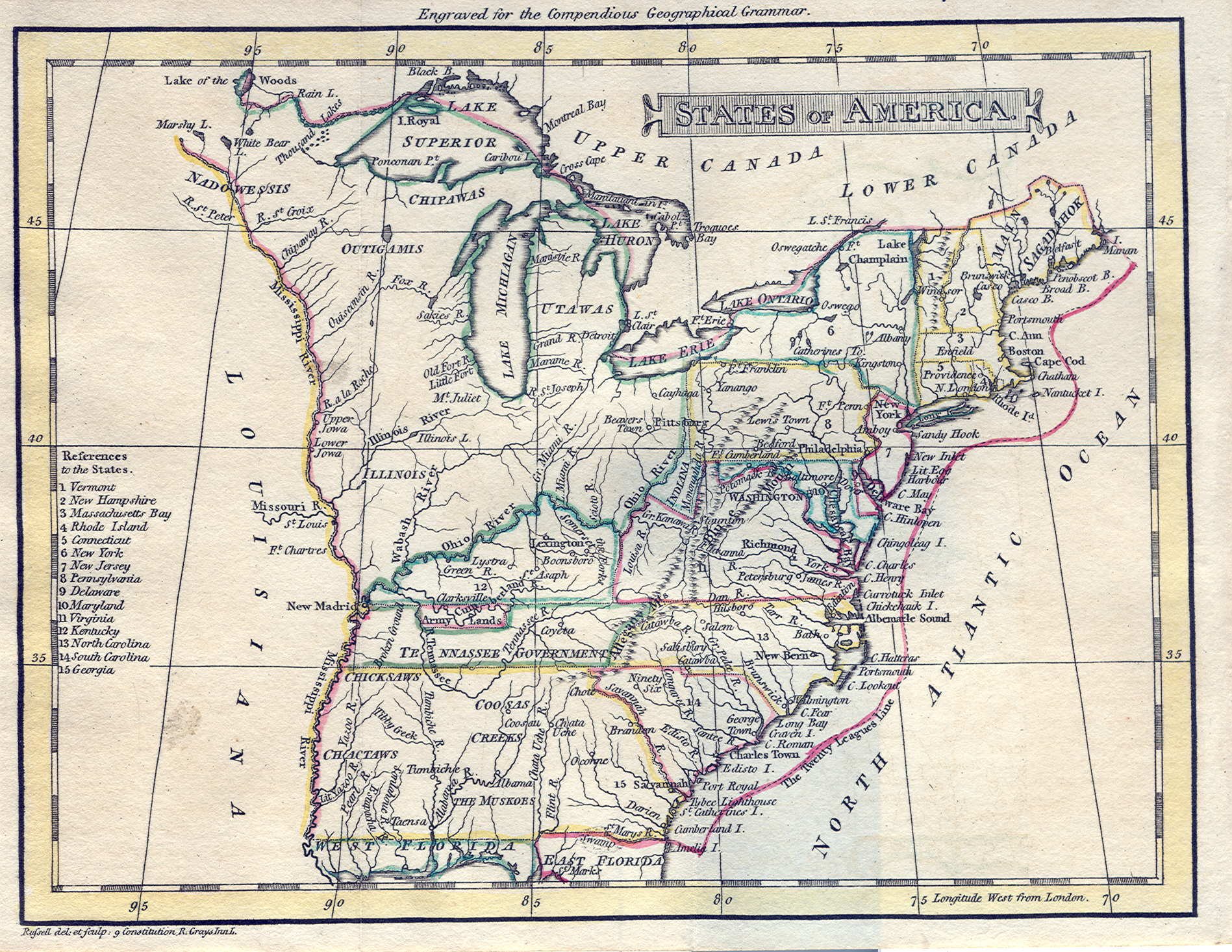
1795.8 STATES OF
AMERICA. Engraved for the Compendious Geographical
Grammer Russell del. et sculp. 9 Constitution R. Grays
Inn L. A map of the eastern United States, Pennsylvania
is shown with modern boundaries but without the Erie
triangle. There are at least two versions of this map,
one with title at top as in this copy and McCorkle #795.10,
the other with title at the bottom right published later (see map 1811.5).
Both probably appeared in editions of William Guthrie's A
System of Modern Geography... . There is a list of
states on the left and, curiously, a twenty league line
along the coast. Kentucky (1792) is listed as a state,
but not Tennessee (1796). Longitude west from London,
blank verso. Scale: 1 inch = 320 miles. Size: 4.5 x 6
inches. |
| |
1795.9 THE UNITED
STATES OF AMERICA, according to the Treaty of Peace of
1784. Russell del: et sculpt. This map resembles the one
above and was made for later editions of William Guthrie's
New Geographical ... Grammer or possibly The
Atlas to Guthrie's System of Geography. The 1783
treaty is misdated but the geography is slightly better. See map 1808.2 for an almost identical later version.
McCorkle #795.11. |
| |
1795.10 THE
UNITED STATES OF AMERICA. Scoles sc. This map appeared in
Universal Geography Made Easy by Charles Smith,
New York 1795, and also in a 1797 Smith gazetteer. It
shows the eastern United States and Pennsylvania is shown
with its modern boundaries including the Erie triangle.
McCorkle #795.12; Wheat & Brun #126, 139. |
| |
1795.11 MAP OF
THE COUNTRY WESTWARD OF LAKE ONTARIO TO THE RIVER
MISSISSIPPI AND SOUTHWARD TO THE 37 OF NORTH LATITUDE
intended more immediately to show the frontier boundary
between the United States and the Indian Tribes as
expressed in their treaty of the 3rd August 1795 with the
particular grants or concessions in favour of the United
States as therein described. This anonymous map is based
partly on Hutchins's map (#1778.14) of Virginia and
Pennsylvania. Only the western half of the state is
included.
. |
| |
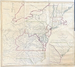
1795.12 (Northwestern Pennsylvania) This manuscript map can be seen at the Darlington Library where it is dated circa 1795 and given the title 'Map of donation and depreciation lands.' It shows the area from Pittsburgh north to Lake Erie with divisions of lands granted after the Revolutionary War to veterans in lieu of service. The counties of Allegheny, Beaver, Butler, Armstrong, Mercer, Crawford, Venango, Warren and Erie are included.
|
 |
1796.1
PENNSYLVANIA DRAWN FROM THE BEST AUTHORITIES by Cyrus
Harris, engraved by A. Dolittle, published by Thomas
& Andrews. This map is from the third edition of The
American Universal Geography by Jedidiah Morse,
published by Thomas & Andrews, Boston c1796. It can
be dated 1789-95 by counties shown. There is no Erie
triangle indicating the map was prepared prior to 1792.
The 1768 Purchase Line from Canoe Place (Cherry Tree) to
the Allegheny River at Kitanning is shown. Delaware is a
separate state. There is a compass rose at upper left and
longitude is from Philadelphia. No. 446 in Wheat &
Brun and listed on page 679 of Phillips. Blank verso.
Scale: 1 inch =25 miles. Size: 8.25 x 13.5 inches. |
 |
1796.2
PENNSYLVANIA, W. Barker sculp. This map was engraved by
William Barker of Philadelphia and published opposite
page 58 in the 1st edition of Carey's American
Pocket Atlas, Philadelphia, printed for Mathew Carey
by Lang and Ustick, 1796, the first pocket atlas printed
in America, Wheat and Brun, No. 445, State I. Towns are
indicated, but not counties or their boundaries.
Waterways and mountains are shown, but no roads. In the
next edition of 1801 roads were added. There were other
editions in 1805, 1813, 1814. This map looks similar to
Joseph Scott's map 1795.1, but is not the same. Longitude
from London at top, from Philadelphia at bottom, blank
verso. Scale: 1 inch = 45 miles. Size: 6 x 8 inches. |
 |
1796.3 THE STATE
OF PENNSYLVANIA, FROM THE LATEST SURVEYS. D. Martin, sct.
Publish'd by J. Reid New York. This map appeared as No.
12 in The American Atlas published by John Reid
(also John Reed), New York 1796. It is notable for the
extensive road network shown and is certainly based upon
Reading Howell maps. A smaller and different map of this
same title with the date 1800 added appeared in Payne's Geography.
Phillips page 680, Wheat & Brun #450-51. Longitude
from London at top, Philadelphia at bottom, blank verso.
Scale: 1 inch = 18 miles. Size: 12.5 x 17.5 inches. |
| |
1796.4 AN
ACCURATE MAP OF THE UNITED STATES OF AMERICA. According
to the Treaty of Peace of 1783. A. Anderson sculp. A map
of the eastern United States with Florida cut off as is
usual in maps from this time, this one is unusual in
showing a "The Twenty League Line" along the
coast. There were several later versions, some appearing
in John Reid's American Atlas. This map is a direct copy of map 1794.6. McCorkle #796.1;
Wheat & Brun #134-36, 143. |
| |
1796.5 A MAP OF
THE UNITED STATES OF NORTH AMERICA drawn from a number of
critical researches. By A. Arrowsmith, geographer Charles
Street, Soho Square. London. Published as the Act directs
by A. Arrowsmith, Charles Street Soho Square. Jany. 1st
1796. This is known as Arrowsmith's "large map"
and it was published again in 1802; it was about 48 x 56
inches and a four sheet version can be seen at the Darlington Library. A smaller version appeared in publications in the
early 1800s. McCorkle #796.2 |
 |
1796.6 THE UNITED
STATES OF AMERICA. W. Barker sculp. Philadelphia. This
map appeared in Carey's American Pocket Atlas,
Philadelphia 1796, along with the Pennsylvania map shown above. Pennsylvania has its modern boundaries. Image courtesy of R.D. Screws.
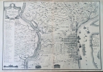
McCorkle #796.3; Wheat & Brun #131. Scale: 1 inch = 150 miles. Size: 10 x 12.5 inches. |
 |
1796.7 A MAP OF
THE UNITED STATES exhibiting post roads & distances
by Abraham Bradley Junr. This map shows the northeastern
states. Later in the year Bradley issued his map of the
entire United States titled MAP OF THE UNITED STATES...,
illustrated in Ristow. These two maps are famous because
they are among the earliest to depict the road network of
the fledgling United States, and were adopted for use by
the fledgling Post Office. North central and northwestern
Pennsylvania are without any roads at all as can be seen
from this detail from the Library of Congress copy.
McCorkle #796.4, 5; Wheat & Brun #127, 128-30. |
| |
1796.8 STEPHENS
PLAN OF THE CITY OF PHILADELPHIA. This is a retitled
version of map 1794.8 published in Stephens
Philadelphia Directory for 1796. In 1797 it was re-engraved,
with Stephens dropped from the title, and published in The
Philadelphia Directory for 1797. Phillips page 702,
Wheat & Brun #467, 470, illustrated in M. P. Snyder,
Figure 105. |
 |
1796.9 THIS PLAN
OF THE CITY OF PHILADELPHIA AND ITS ENVIRONS, (shewing
the improved parts) is dedicated the the mayor, aldermen
and citizens thereof, by their most obedient servant,
John Hills, surveyor and draughtsman. May 30th 1796.
Engraved by John Cooke, of Hendon, Middlesex.
Philadelphia. Published and sold by John Hills. Surveyor
& Draughsman 1797. This map could be dated either
1796 or 1797; there was also a 1798 version illustrated
in M. P. Snyder, Figure 121. Phillips page 702, Wheat
& Brun #468, 471. The image here is from the Library
of Congress. |
| |
1796.10 PLAN OF
THE TOWN OF ERIE ON LAKE ERIE, F Molineux del, Published
as the Act directs, F Shallus sculpt. The accompanying
copyright statement in the Library of Congress copy says:
"Deposited 16 Sepr. 96 by Frederic Molineux as
Author." Wheat & Brun #449. |
| |
1796.11 THE
SUSQUEHANNA RIVER AND SURROUNDING AREAS. W. Barker, sculp.
This map shows primary rivers and roads from Oswego south
to the Chesapeake, and from New York to the western
border of Pennsylvania. It appeared in A Description
of the River Susquehanna by Jonathan W. Condy. Wheat
& Brun #311. |
 |
1796.12 (Northwest
Pennsylvania) This is an untitled manuscript map known as
HECKEWELDER'S MAP that is illustrated in Winsor (1899)
dated 1796 and shown here. It depicts the Indian trails
around Pittsburgh used to travel back then. John
Heckewelder became interested in the American Indians and
spent most of his life, covering the latter 18th century,
living and traveling among them mostly in Pennsylvania,
New York, and Ohio. He kept journals and wrote a couple
of books which are a major source of information on the
eastern Indians of the period. |
| |
1796.13 BOWLES'S NEW ONE-SHEET MAP OF THE INDEPENDENT STATES OF VIRGINIA, MARYLAND, DELAWARE, PENSYLVANIA, NEW JERSEY, NEW YORK, CONNECTICUT, RHODE ISLAND, &C. comprehending also the habitations & hunting countries of the confederate Indians. By Lewis Evans. Printed for the Proprietors Bowles & Carter,No. 69 in St. Paul's ChurchYard, London. This map is a very late Bowles version of the famous 1755 Evans map. It can be seen at the Darlington Library, where it is dated circa 1796.
|
 |
1796.14 THE UNITED STATES OF AMERICA. This map shows the region from Nova Scotia to Georgia and west to the Mississippi, and appeared in editions of Elements of Geography by Benjamin Workman, Philadelphia, 1790 and later. The example shown by McCorkle (#790.6) includes the Erie triangle and so must come from an edition after 1792. The earliest edition of Workman seen with this map is Elements of Geography, by Benjamin Workman, A.M., The sixth edition. Philadelphia: Printed and sold by John McCulloch, No. 1, North Third Street, 1796. So, that date is used for it here. The same map was seen in the ninth edition dated 1803, and it is possible it appeared in all editions after 1792. The Library of Congress has second and third editions dated 1790; and a 16th edition dated 1816; as well as 1811, 1809, 1807, 1796 editions. Scale: 1 inch ~ 300 miles. Size: 8 x 8 inches.
|
| |
1796.15 THE UNITED STATES OF NORTH AMERICA WITH THE BRITISH TERRITORIES AND THOSE OF SPAIN. Engraved by Wm. Faden. 1796. This map was seen at auction and is apparently from a Faden atlas. It shows the eastern United States to beyond the Mississippi, southern Canada up to Newfoundland, and includes Florida. It is a late edition of map 1777.5.
|
 |
1796.16 TO THE
CITIZENS OF PHILADELPHIA THIS PLAN OF THE CITY AND ITS
ENVIRONS IS RESPECTFULLY DEDICATED by the Editor. P. C.
Varle Geographer & Enginr. del.; R. Scott sculp.
Philada. The dating of this map is uncertain, Wheat &
Brun #465 date it circa 1794, and there is an 1802
version with additions. This map was seen at auction
dated 1796 quoting the August 3, 1796, issue of the
Pennsylvania Gazette as advertising the map for sale. It
is illustrated in M. P. Snyder, Colorplate 12, dated 1796;
and a 1802 later version in Figure 119 . A facsimile of
this map with the date 1776 was put out in 1926 by a
Philadelphia bank. There is also apparently a
contemporary French manuscript version, see
Docktor
#294V7. The image shown here is a reproduction from Street Atlas of Philadelphia by Wards, 1895; published by Chas. D. Kaufmann, 38 N. 6th St. Philadelphia. Subtitled 'Philadelphia in 1796,' it was apparently originally prepared for the 1876 centennial as a single and then published in the atlas. Scale: 1 inch ~ 3 blocks. Size: 14.5 x 20 inches. |
 |
1797.1
PENNSYLVANIA entworfen von D. F. Sotzman, Hamburg by Carl
Ernst Bohn 1797. zu Ebelings erdbeschrcibung von Amerika.
This large map (28 x 16 inches) of Pennsylvania was
engraved by Sotzmann for Christopher Ebeling's Erdbeschreibung
von Amerika, a project ended after only ten maps of
America were completed; the series is discussed in
Chapter 11 of Ristow. The Pennsylvania map emphasizes the
layout of land holdings. This image is from a modern
reproduction. Phillips page 680. |
 |
1797.2 UNITED
STATES OF AMERICA, London Pubd. as the act directs Feby
18th, 1797, by J. Wilkes. Neele Sc. 352 Strand (McCorkle
#797.4). This map by Samuel John Neele is from Encyclopaedia
Londinensis published in 1797 by John Wilkes. The
map shows the country from Maine to northern Florida and
west to the Mississippi. Pennsylvania does not have the
Erie triangle, several towns are identified and the word
canal appears above the Schyulkill River. Listed on page
872 of Phillips with no source. There was another version
of this map published by G. Kearsley Fleet Street London,
March 11.th 1797. It has the title in a cartouche and can
be seen at
MapForum.Com
, Issue 1. Longitude west from
Greenwich. Blank verso. Scale: 1 inch = 240 miles. Size:
7.25 x 9.5 inches. |
 |
1797.3 MAP OF THE
NORTHERN PART OF THE UNITED STATES OF AMERICA by Abraham
Bradley Junr B Callender scp. Engraved for Morse' s
American Gazetteer. This map is from the 1797 edition of
Morse's American Gazetteer. The region covered
is from Maine to Virginia and west to the Mississippi.
Future states are identified as Ist State (Ohio), II
State (Indiana), III State (Illinois), IV State (Michigan),
V State (Wisconsin). There was an English version in 1798
by John Russell which is similar except for the note at
bottom, McCorkle #797.1, 798.6; Wheat & Brun #158.
This copy has been double printed with an offset printing
showing through weakly. Blank verso. Scale: 1 inch = 100
miles. Size: 9 x 16 inches. |
| |
1797.4 GLI STATI
UNITI DELL' AMERICA IL CANADA, E LA FLORIDA Gio. Ma.
Casini som inc. This is a map of the eastern United
States and southern Canada which appeared in Nuovo
Atlante Geografico Universale by Giovanni Casini,
Rome 1801; there was a 1798 version also and several
sheets from it are illustrated in Portinaro and Knirsch.
Appearing in the same atlas was a map of the northeast
with the same initial title followed by a list of the
states covered: ... Il Nuovo Yersey, La Pensilvania, Il
Delaware... etc. This map shows only the eastern half of
Pennsylvania. The title map shows the entire eastern
United States. McCorkle #797.2, 3, 798.1. |
 |
1797.5 CARTE DE
LA PARTIE SEPTENTRIONALE DES ETATS UNIS, COMPRENANT LE
CANADA, LA NOUVELLE ECOSSE, NEW HAMPSHIRE, MASSACHUSET'S
BAY, RHODE-ISLAND, CONNECTICUT, NEW-YORK, ETAT DE VERMONT
AVEC PARTIE DE PENSILVANIE ET DE NEW-JERSEY. Andre scrip
Tardieu sculp. As the title implies, this map includes
only eastern Pennsylvania which is shown extending
to 43 degrees. Only a slice of present day northeasterm Pennsylvania down to Philadelphia is shown and is mostly blank. The map appeared in Atlas Universel de Geographie Physique et Politique by
Edme Mentelle, Paris 1797 and later. McCorkle #797.5. Blank verso, longitude from Paris at bottom, from Ferro at top. Scale: 1 inch = 60 miles. Size: 12.5 x 16.5 inches. |
 |
1797.6 CARTE
GENERALE DES ETATS UNIS DE L'AMERIQUE SEPTENTRIONALE,
renfermant aussi quelques provinces Angloises adjacentes.
Tardieu sculp. Andre scrip. McCorkle #797.6. Another map
from Atlas universel, this one shows the United
States from Newfoundland to Florida and west to beyond
the Mississippi. The states are named but not much else.
This map is very similar to #1787.2 with the same name.
Longitude from Ferro at top, Paris at bottom. Scale: 1
inch = 170 miles. Size: 12.5 x 17 inches. |
| |
1797.7 UNITED
STATES OF AMERICA agreeable to the Peace of 1783. A small
map from Elements of Geography by John Walker,
Dublin 1797, it shows the states from Massachusetts to
South Carolina. Pennsylvania is shown extending to Lake
Ontario with an irregular western boundary. The map also
appeared in An Atlas of Walker's Geography and
Gazetteer, Dublin: Thomas Morton Bates, 1798.
McCorkle #797.7 |
| |
1797.8 PLAN OF
BEULA PENNSYLVANIA. W. Barker sculp. The dating is
uncertain. Beula was founded around 1797 and was one of
the first towns in Cambria County. It was started by a
group of Welsh immigrants led by Rees Lloyd; whose son
Eben is the namesake of the present county seat of
Ebensburg. Beula no longer exists, and Ebensburg was
built on an adjacent hill using material from the
demolished Beula. Wheat & Brun #452. |
| |
1797.9 PLAN FOR
THE NORTH EAST PUBLIC SQUARE. This is a land plot near
Sixth and Vine streets and the German Lutheran Burying
Ground in Philadelphia. It was published in a pamphlet The
Committee Appointed to Examine into the Title. Wheat
& Brun #469 date it to 1797. |
 |
1797.10 REPORT OF
A ROAD FROM LOVE'S GAP TO SHADES MILL, CONFIRMED 30
FEET WIDE, ORDER EXIT TO GEORGE (?)URGLE, JUNE 22, 1797
NOT PAID. This is the verso title of a manuscript map on
watermark paper of a road survey done in 1796 in Lycoming
County. The survey is signed by Hugh White, Wm Montgomery,
John Chattam, John Mccormic. The map, about 6 x 10 inches,
is on the
top portion
and shows the river and a
marked road. The following was found in Chapter 19 of History
of Lycoming County, Pennsylvania : including its
aboriginal history, the colonial and revolutionary
periods, early settlement and subsequent growth ..., edited
by John F. Meginness, Brown & Runk, Chicago 1892:
"Several new roads were reported to this court. One
led from Newberry to Thomas Brooks's; another from Robert
Crawford's to Antes's grist mill, and still another from
the same mill to the great road leading up the
river. When December sessions convened Hugh White,
William Montgomery, and others reported that they had
laid out a road from Love's gap to Shade's mill
and other viewers reported that a road had been laid out
from the bank of Loyalsock creek through the lower end of
Andrew Carson's meadow across the mouth of a
gut and thence straight forward until it
intersected the old road." These place names have
passed on, however Loyalsock Creek is near Williamsport.
Lycoming County was founded in 1795 and was much bigger
than the present county extending north to the border and
west to Clarion County, so the location could also be in
a daughter county. |
 |
1797.11 A MAP OF THE UNITED STATES OF AMERICA. with Part of the Adjoining Provinces, from the Latest Authorities. This map is similar to map 1794.3 and has the same name. It differs notably by including Tennessee as a state which would date it after 1796. There is no attribution on the map, but it is believed to come from A New and Comprehensive System of Universal Geography by Henry Moore, printed by MacDonald and Son, London, circa 1797. This copy has been mis-colored to show the western boundary of Pennsylvania all wrong, probably because the western boundary line has not been engraved, like it is on the 1794 map. Originally folded with blank verso, longitude west from Greenwich. Scale: 1 inch = 165 miles. Size: 8.5 x 10.5 inches. |
 |
1798.1 A MAP OF
PENNSYLVANIA, DELAWARE, NEW JERSEY & MARYLAND WITH
THE PARTS ADJACENT. Engraved for RP's Histy of Penna.,
Thackara Sc. This map is from The History of
Pennsylvania, in North America. From the Original
Institution and Settlement of that Province, under the
first Proprietor and Governor William Penn, in 1681, till
after the Year 1742...by Robert Proud, Philadelphia:
Printed and Sold by Zachariah Poulson, Junior, 1797 -
1798. This is the first real history of the state
published. Delaware is also marked 'Territories of
Pennsylvania', indicating this map may have been printed
from an old plate that was recut. No. 312 in Wheat &
Brun. Longitude from Philadelphia. Scale: 1 inch = 28
miles. Size: 12.25 x 15 inches. |
 |
1798.2 A MAP OF
THE UNITED STATES OF AMERICA. Engraved for Morse's
Elements of Geography Published by Thomas & Andrews,
Boston. 1798. The eastern United States is shown with
little detail. This map is an updated version of map 1795.6 with the same name. It also appeared in later editions of Morse's book and this particular copy comes from Elements of Geography, containing a concise and comprehensive view of that useful science, by Jedidiah Morse, D.D., Fifth edition improved. Boston: Printed for Thomas & Andrews, No. 45 Newbury-street...July, 1804. J. T. Buckingham, Printer. McCorkle #798.3; Wheat & Brun #141 |
| |
1798.3 BRITISH
POSSESSIONS IN NORTH AMERICA AND UNITED STATES WITH
VERMONT, KENTUCKY AND TENNASSEE. W. Palmer sculp
Published by Wm. Faden Jany. 1. 1798. This map appeared
in Faden's Atlas Minimus Universalis, London
1798. It shows the eastern United States and recognizes
three new states. Pennsylvania extends to Lake Ontario.
McCorkle #798.4 |
 |
1798.4 PART OF THE UNITED STATES OF NORTH AMERICA. Published 15th. Novr. 1798 by J. Stockdale, Piccadilly. This map of the northeast appeared in Travels Through the States of North America by Isaac Weld, London 1798 and later. Publishing "travels" in America became something of a rage at the turn of the 19th century and Weld's was one of the most popular. There are German and French versions also: McCorkle #798.5, 799.6, 800.4. The coverage extends from southern Maine to North Carolina and west to Kentucky. An inset at lower right shows South Carolina and Georgia. Weld's book also contains A NEW MAP OF UPPER AND LOWER CANADA, which is a map of the Great Lakes on which the United States area is a blank; and a map of Niagara Falls. Blank verso, longitude west from London at top, from Philadelphia at bottom. Intaglio print, originally folded. Scale: 1 inch = 50 miles. Size: 16 x 18.5 inches. |
| |
1798.5 PART OF
BETHLEHEM FARMS ON THE SOUTH SIDE OF THE RIVER..., a
manuscript surveyed land map online at the Bethlehem
Digital History Project
. |
 |
1798.6 GLI STATI UNITI DELL' AMERICA IL CANADA, E LA FLORIDA CARTA GENERALE DELINEATA SULLE ULTIME OSSERVAZNI, ROMA PRESSO LA CALCOGRAFIA CAMERALE 1798. Gio. Ma. Cassini inc. (i.e. Giovanni Maria Cassini). Published in Nuovo Atlante Geografico Universale. This Italian map of the young United States is derived from Zatta's copy of Mitchell's map of North America (see map 1778.7) and thus presents a very out of date picture; another case where an old map has had a new United States title (Stati Uniti) added to it. The Florida peninsula is misshapen; Georgia is a narrow strip of land; the Carolinas, Virginia, and Pennsylvania all stretch to the Mississippi River. Western New York is part of Pennsylvania as indeed it almost was. The "Luigiana" territory is identified. Numerous Indian tribes are located. The large title cartouche at bottom right has a vignette of natives in the middle of a hunt. Intaglio print, blank verso. Longitude east from (probably) Ferro. Scale:1 inch = 166 miles. Size: 13.5 x 18.75 inches. |
 |
1799.1 (East
Coast) This untitled map of the United States and
southern Canada bears the imprimatur Smith & Jones
Sculp. 13 Pleasant Row Pentonville (McCorkle #799.8). It
is from an English edition of Duke de la Rochefoucauld-Liancourt's
Travels..., the full title of which is Travels
through the United States of North America, the country
of the Iroquois, and Upper Canada, in the years 1795,
1796, and 1797 : with an authentic account of Lower
Canada, By the Duke de La Rochefoucault Liancourt ...,
with translation by H. Neuman, published by R. Phillips,
London 1799. See Phillips, page 873. There are several
versions of this map, one has across the top the title:
MAP OF THE UNITED STATES , CANADA &C. intended to
illustrate the travels of the Duke de la Rochefoucault
Liancourt (McCorkle #799.8). The original French version
is titled: CARTE GENERALE DES ETATS-UNIS DE L'AMERIQUE
SEPTENTRIONALE, Divisee En Ses 17 Provinces. The work is
in 2 volumes with 3 folded maps, a 'General Map' which is
this one, and 2 more local maps (see map 1799.11 below).
The region from the Great Lakes to northern Florida and
west to the Mississippi is shown. Pennsylvania appears
without the Erie triangle acquired in 1792. A road is
shown across southern Pennsylvania going on into Ohio.
The map includes 'Franklinia', the one time state of
Franklin, named after Benjamin Franklin. It was formed in
1784 by settlers with John Sevier as governor, but never
officially recognized by Congress. Sevier later became
the first governor of Tennessee, admitted in 1796, and
the state of Franklin was reannexed to North Carolina.
Thus, the map would appear to represent the country as it
was between 1784 and 1792 or 1796. Blank verso. Scale: 1
inch = 105 miles. Size: 16 x 13 inches. |
| |
1799.2 CARTE
GENERALE DES ETATS-UNIS DE L'AMERIQUE SEPTENTRIONALE
divisee en ses 17 Provinces. Par L. Capitaine Ier.
Ingenieur et Associe de la Carte genele. de la France en
180 fles. This is the original French version of the map
above from Liancourt's book which, unlike the English
version, has a cartouche title (McCorkle #799.3). |
| |
1799.3 CARTE DES
ETATS-UNIS PROVINCES SEPTENTRIONALES. This is a map of
the northeast from the French edition of Liancourt's Travels...,
Voyage dans les Etats-Unis d'Amerique, Paris
1799. Like Weld's Travels..., Liancourt's were
very popular. Pennsylvania is shown accurately with its
modern boundaries. The English version also contained
this map titled MAP OF THE NORTHERN PROVINCES OF THE
UNITED STATES, see map 1799.12 below. (McCorkle #799.7). McCorkle (#799.2)
conjectures the French map was prepared by Louis
Capitaine as was the map above. |
 |
1799.4 ETATS UNIS
DE L'AMERIQUE. Blondeau sculpt. This map of the eastern
United States appeared in a French edition of William
Guthrie's geography Atlas Universel pour la Geographie
(McCorkle #799.1). Pennsylvania is shown without the
Erie triangle; Indian tribes and "Army Lands"
are identified. Longitude west from Ferro at top, from
Paris at bottom; blank verso. There is an error on the
scale bar, with 200 printed instead of 250. Scale: 1 inch
= 200 miles. Size: 7 by 8 inches. |
| |
1799.5 (Eastern
United States) An untitled map from a German school atlas,
at bottom is Entworfen von F. L. Gussefeld. Gestochen von
C. Westermayr. The map is blank and was apparently
intended as a school exercise of fill in the blanks (McCorkle
#799.4). |
| |
1799.6 A NEW
CHART OF AMERICA WITH THE HARBORS OF NEW YORK, BOSTON
&C. Drawn from the latest authorities by W. Heather.
1799. Stephenson sculp. London, published as the Act
directs, June 1st. 1799 ... . This navigation chart from The
Marine Atlas, or Seaman's Complete Pilot... is
included because it contains an inset of Delaware Bay and
River as far north as Philadelphia (McCorkle #799.5). |
 |
1799.7 THE UNITED
STATES OF AMERICA. Engraved for Payne's Universal
Geography published by J. Low New York. This is a map of
the eastern United States from A New and Complete
System of Universal Geography published in multiple
volumes circa 1798-1800. Payne's geography also contains
state maps, the one for Pennsylvania being dated 1800,
and so listed under that date. This map shows the eastern
United States from Maine to a cutoff Florida and west to
beyond the Mississippi; Pennsylvania has its modern
boundaries. This same map was published in Low's Encyclopedia in 1805. McCorkle #799.9. Longitude from Philadelphia
at bottom, London at top, blank verso. Scale: 1 inch =
150 miles. Size: 9.75 x 12 inches. |
| |
1799.8 UNITED
STATES OF AMERICA. London published as the Act directs,
March 1st. 1799 by G. G. & J. Robinson Paternoster
Row. This map comes from Atlas to Crutwell's
Gazetteer by Clement Crutwell, London circa 1799. It
shows the eastern United States, Pennsylvania extends to
Lake Ontario with an irregular western boundary (McCorkle
#799.10). |
| |
1799.9 DIE
VEREINIGTEN STAATEN VON NORDAMERIKA nach Arrowsmith's und
Lewis Karten vom Jahre 1795 und 1796. Nurnberg 1799. in
der Schneider-und Weigelschen K. K. privilegirten
Kunsthandlung. This is a German map of the United States
crediting Arrowsmith and Lewis (McCorkle #799.11). |
| |
1799.10 A MAP OF
THE MIDDLE STATES OF NORTH AMERICA. This map of the area
from New York to Virginia appeared in Description of
the Settlement of the Genesee Country by Charles
Williamson. There are three versions of increasing text
and detail. All three are illustrated in Schwartz &
Ehrenberg who date them 1798, 1799, and 1800. Wheat &
Brun #314-16. |
 |
1799.11 MAP OF
THE NORTHERN PROVINCES OF THE UNITED STATES, printed for
R. Phillips, 71 St Paul's Church Yard. Russell Junior
sculp. This map is from an English edition of Duke de la
Rochefoucauld-Liancourt's Travels... (McCorkle #799.7,
see also map 1799.1 above). It shows the northern United
States from Maryland to Maine and west to include all of
Pennsylvania. Roads are prominent in this image showing
most of the map. This map is the same as map 1799.3 above except for the title. Longitude from Washington, blank verso.
Scale: 1 inch = 40 miles. Size: 12.5 x 20 inches. |
| |
1799.12
BOWLES'S NEW ONE-SHEET MAP OF THE UNITED STATES OF AMERICA; WITH THE TERRITORIES BELONGING TO GREAT BRITAIN AND SPAIN. London: Printed for & Sold by the Proprietors:Bowles & Carver, at their Map & Print Warehouse No. 69 St. Paul's Church Yard. McCorkle (768.1) dates this issue of D'Anville's map circa 1799 and that dating is use here. This was apparently the final English version of map 1768.3 to be issued, this time without any mention of the original author. The name of the prominent publisher Carrington Bowles is used instead. |
| |
1799.13
A SKETCH OF THE ADJACENT TERRITORIES OF CANADA & THE UNITED STATES. Engraved for the Commercial and Agricultural Magazine. Pub'd by V. Griffiths, Paternoster Row.This map from the Volume 1 1799 issue of the Commercial and Agricultural Magazine covers the region from Lake of the Woods east to the St. Lawrence River and south to near New Madrid at the confluence of the Mississippi and Ohio rivers. Lake Superior shows a few spurious islands and only a few place names are shown. An Indian Road to James Bay is noted near the top of the map. States and territories are not shown or named and the emphasis is on showing the rivers. This magazine was published from August 1799 to 1807, apparently bimonthly. |


