Maps from this
decade were largely concerned with how the North American
continent looked after the Treaty of Paris in 1763 ended the
French and Indian War.
 |
1760.1 A
MAP OF CANADA AND THE NORTH PART OF LOUISIANA WITH THE
ADJACENT COUNTRYS. By Thos. Jefferys, geographer to His
Royal Highness the Prince of Wales. T. Jeffreys sculp.
1760 Published by Thos. Jeffreys near Charing Cross
London. This small scale map comes from Jeffreys' The
Natural and Civil History of the French Dominions in
North and South America, London 1760; and also
appears in his General Topography, London 1768.
It shows the huge region between 40 and 60 degrees
latitude west to beyond Lake Winnipeg. Pennsylvania is
named at the bottom of the map. This image is from the
Library of Congress where it is dated 1762. There is
another version of this map of the same name and region
but which looks distinctly different. McCorkle #760.4,
Sellers & van Ee #95. |
 |
1760.2 A
PLAN AND PERSPECTIVE VIEW OF PITTSBURGH. E. A. Day. This
is a manuscript map of uncertain date; Sellers & van
Ee (#1330) place it circa 1760s. This image is from the Library of Congress. |
| |
1760.3
SKETCH OF THE COUNTRY FROM FORT DU QUESNE FO NIAGARA AS
DESCRIBED BY AN INTELLIGENT INDIAN WHO HAD RESIDED THERE
FOR A CONSIDERABLE TIME. This anonymous manuscript map of
uncertain date shows the region from Pittsburgh to
Niagara; the Allegheny River is called the Ohio. It is
dated circa 1760 by Brown (#37) probably because the name
"Pittsboro" appears under Fort Du Quesne. The
original is in the Clements Library. |
| |
1760.4
ANCIENT BOUNDARIES OF MARYLAND
AND PENNSYLVANIA. This map is listed in the Maryland
Archives, MSA SC 1399 -1-251, dated circa 1760-68 with
Joint Commissioners as the author. It is from Minutes
of the Joint Commissioners, Lord Baltimore and the Penns,
from November 19, 1760 to November 9, 1768. |
| |
1760.5 PLAN OF
FORT LIGONIER done by Theodosius McDonald for George
Morton February ye 8th Annoque Domini 1760. This
manuscript map (Stotz III-8) shows Loyalhanna Creek, the
fort, and surrounding grounds including the location of
the battle of October 12, 1758. The original is in the
Clements Library. |
| |
1760.6 MAP
SHOWING CONFLICTING CLAIMS OF CONNECTICUT AND
PENNSYLVANIA AND THE PURCHASES OF THE SUSQUEHANNAH AND
THE TWO DELAWARE COMPANIES WITHIN THE DISPUTED AREA,
Frank Bobb, 1760. A land ownership manuscript map in the
collections of the Historical Society of Pennsylvania.
Docktor
#
260B7. |
 |
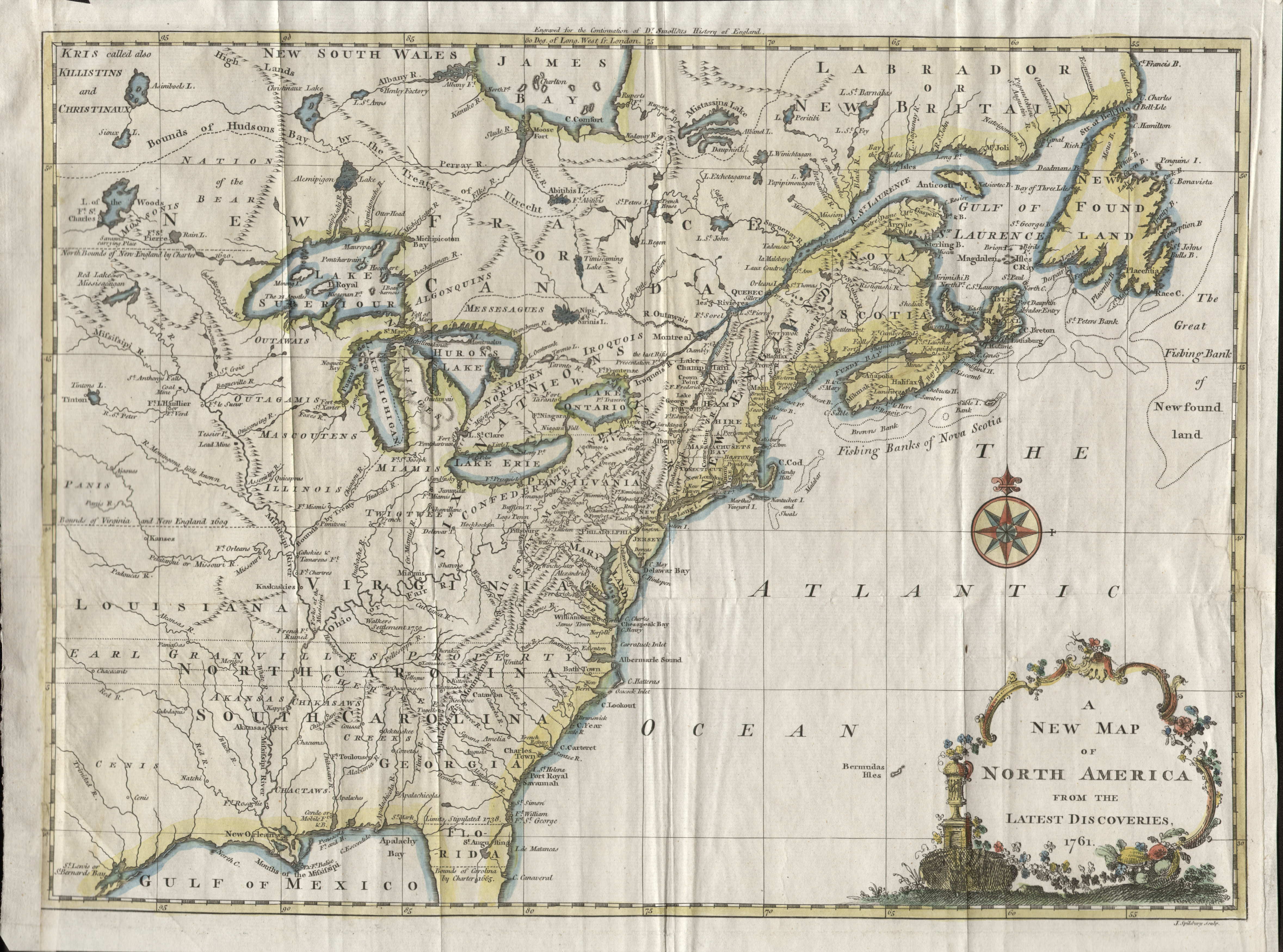
1761.1
A NEW MAP OF NORTH AMERICA FROM
THE LATEST DISCOVERIES 1761, engraved for the
continuation of Dr. Smolletts History of England, J.
Spilsbury, Sculp. This map is from Continuation of
the Complete History of England by Tobias Smollett,
London 1760-61, published in 50 weekly numbers and
apparently continued to circa 1765. It shows the colonial
possessions in North America from Newfoundland to Florida
and west to the Mississippi. Pennsylvania extends to the
43rd parallel and has an irregular western boundary. The
colonies are shown with their boundaries extending past
the map's western border with various treaty and charter
boundaries shown. The fishing banks off Canada are
prominently noted. The color is probably not original.
The map also appeared in the London Magazine of
February, 1763, with the date changed in the title.
Tobias Smollett is otherwise famous for writing the novel
The Expedition of Humphrey Clinker. McCorkle #761.3,
763.7; Sellers & Van Ee #89. Longitude west from
London, blank verso. Scale: 1 inch = 166 miles. Size: 11
x 15 inches. |
| |
1761.2
CANADA, J. Gibson sculpt. This map, from Gibson's A
New General and Universal Atlas, includes the region
between 41 and 50 degrees latitude and west to include
the Great Lakes. The English colonies have elongated
north-south boundaries and Pennsylvania is named, but
nothing else identified. McCorkle #761.1 |
| |
1761.3
AN ACCURATE MAP OF CANADA, WITH THE ADJACENT COUNTRIES;
exhibiting the late seat of war between the English &
French in those parts. Univers. Mag. J. Hinton, Newgate
Street. R. W. Seale del. et sculp. This map from the Universal
Magazine of February, 1761, shows the region from
Maine to Pennsylvania west to include the Great Lakes and
north to 52 degrees. Pennsylvania's boundary is carried
to 43 degrees, Philadelphia and "Pitsburg" are
named, along with Harris T., Reading, Easton, Franks T.,
and the major rivers. The map can be seen at the Darlington Library.
McCorkle #761.2 |
 |
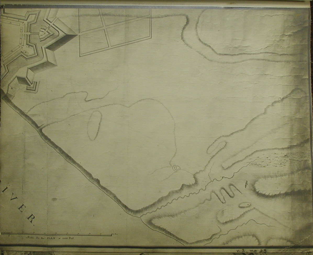
1761.4
PLAN OF FORT PITT and parts adjacent with both rivers.
This is a manuscript map of the fort done by Bernard
Ratzer circa 1761. It is reproduced in Hulbert(1907) with
this date in four plates, all shown here,
plate 2
,
plate 3
,
plate 4
. The complete plan is also
shown in Stotz II-61, and at the Darlington Library.
This plan had to be somewhat
conjectural as the fort took several years to complete. |
| |
1761.5
A PLAN OF THE CITY OF
PHILADELPHIA, WITH THE COUNTRY ADJACENT. This map is a
copy of the city grid area of Scull & Heap's map 1752.1.
The city is shown along the Schuylkill and Delaware
Rivers with sites and names surrounding. It was published
in A Curious Collection of Voyages... by J.
Newberry of London in 1761; and in a publication titled The
World Displayed in 1769 per a listing in the
Heritage Map Museum CD. Illustrated in M. P. Snyder,
Figure 25. |
| |
1761.6 MAP OF THE
COUNTRY ADJACENT TO FORT ON FRENCH CREEK. This undated
manuscript map shows the region around the juncture of
French Creek with the Allegheny. The dating is uncertain
but it likely dates circa 1760-62. When the French fled
back to Canada they destroyed Fort Machault and the
British decided to build a replacement. They chose a site
closer to French Creek and started construction in 1760.
This map is illustrated in Stotz (II-70) and the original
is in the Clements Library. |
| |
1761.7 A NEW MAP OF VIRGINIA, FROM THE BEFT AUTHORITIES: by T. Kitchin Geog.
This map is only included here because a thin strip of southern Pennsylvania is shown. The map can be seen
at the Darlington Library,
where it is dated 1761. It probably comes from one of the London magazines of the period.
|
 |
1762.1 AN
ACCURATE MAP OF THE BRITISH EMPIRE IN NTH. AMERICA AS
SETTLED BY THE PRELIMINARIES IN 1762, J. Gibson Sculp.,
from the Gentleman's Magazine 1762 (McCorkle #762.1).
This small scale map has an inset of the entrance to the
Mississippi River. The English magazines quickly
published maps relating to current news, in this case the
approaching end of the war with France. The shaded area
is the land considered ceded to Great Britain from France
and Spain. The map was originally folded. Pennsylvania
extends to the 43rd parallel and Philadelphia is named.
Longitude west from London, blank verso. Scale: 1 inch =
250 miles. Size: 8.25 x 9.75 inches. |
 |
1762.2 A
NEW AND CORRECT MAP OF THE PROVINCES OF NEW ENGLAND, NEW
YORK, AND CANADA, OR NEW FRANCE. J. Gibson sculpt. A map
from The American Gazetteer, London 1762,
showing the region from St. Lawrence Bay west to Lake
Huron and south to Pennsylvania. The counties of Bucks,
Berks, and Northampton are named, along with the rivers
and several towns. The
map extends south to 40 degrees and shows most of
Pennsylvania except the southern strip. Philadelphia is
not shown. McCorkle #762.2. Scale: 1 inch = 125 miles.
Size: 11 x 13.5 inches. |
 |
1762.3
TO THE MAYOR, RECORDER, ALDERMAN, COMMON COUNCIL, AND
FREEMEN OF PHILADELPHIA THIS PLAN OF THE IMPROVED PART OF
THE CITY SURVEYED AND LAID DOWN BY THE LATE NICHOLAS
SCULL, ESQR., SURVEYOR GENERAL OF THE PROVINCE OF
PENNSYLVANIA is humbly inscrib'd by the editors.
Philadelphia; Sold by the editors, Matthew Clarkson and
Mary Biddle. 1762. This map of Philadelphia has inset
plans of previous maps by Thomas Holme and Benjamin
Eastburn. Wheat & Brun #456 state that the most
probable engraver is Henry Dawkins. Mary Biddle was the
daughter of Nicholas Scull, who evidently planned this
map before his death in 1761. This was an important map
for the time, as it was copied by European mapmakers.
This image is from a poor modern reproduction. Sellers
& van Ee #1308, Phillips page 698. Illustrated in M.
P. Snyder, Figure 27. |
 |
1762.4
CANADA, LOUISIANE, POSSESSIONS ANGL? par le S. Robert de
Vaugondy geog? ord? du Roi ... avec privilege 1762. Grave
par E. Dussy. A. sculp. This small scale map of eastern
North America appeared in several editions of Atlas
Portitif. The English colonies are confined to the
coast by a boundary line, Pennsylvania and Philadelphia
are named. There is a large inset of northwestern North
America, largely unknown as the map shows. A note at left
mentions Delisle. This map appears in several states,
three illustrated by McCorkle #762.3, 778.15, 794.13,
also in Sellers & van Ee #96. Later versions were
titled CANADA, LOUISIANE, ETATS-UNIS after the United
States was formed. Blank verso except for a large "43",
presumably the page number. Longitude east from Ferro.
Scale: 1 inch = 310 miles. Size: 9.5 x 11.5 inches. |
 |
1762.5 A
NEW AND ACCURATE MAP OF THE PROVINCES OF PENSILVANIA,
VIRGINIA, MARYLAND AND NEW JERSEY. J. Gibson, sculpt. This is a magazine map
that appeared in the
The American gazetteer,
containing a distinct account of all the parts of the New
world: London, Printed for A. Millar...1762. It shows the region from New York to
Virginia and west to include Lake Michigan, and is based
on the maps of Lewis Evans. Pennsylvania has an irregular western border and extends to 43 degrees latitude. The map has several short notes mostly about Indian tribes. Phillips page 674. Blank verso, longitude west from London. Scale: 1 inch = 65 miles. Size: 10.75 x 13.5 inches. |
| |
1762.6 A SKETCH
OF THE SEVERAL INDIAN ROADS LEADING FROM FORT PITT TO
SIOTO, LAKE ERIE, &C. Takn. from a Draft (made on a
Tour thro yt. Country in 1762 by Mr. Hutchins - then in
the Indian Department - Guy Johnson fect.) Johnson was
head of the "Indian Department" for the British
and Thomas Hutchins (later more famous) was a draftsman
attached to the British for a time. This is a well made
manuscript map showing the region between Fort Pitt and
Lake Erie west to the Miami River in Ohio, and is
illustrated in Brown #38. The original is in the Clements
Library and was probably made by Johnson later, circa
1763-64, listed in Guthorn (1972) #65-8. |
| |
1762.7 SURVEY OF
THE ENVIRONS OF FORT PITT. This large (21 x 43 inches)
ink and watercolor manuscript map is credited to British
engineer Lieutenant Elias Meyer and is in the British
National Archives (former Public Record Office). It is
undated, but thought circa 1761; however Stotz (II-63)
more logically dates it 1762. The rivers, painted in blue,
have their present names and the fort as well as the
beginnings of Pittsburgh are shown on this attractive map.
It also indicates the previous Fort Duquesne showing the
huge difference in scale between the two forts. |
| |
1762.8 (Fort Pitt)
This untitled and undated manuscript map by Meyer was
probably prepared in conjunction with the one above and
is also in the British National Archives. It is a larger
scale view of the fort itself. Stotz (II-66) calls this
the best of the contemporary fort drawings. |
| |
1762.9 A TOUR
FROM FORT CUMBERLAND NORTH WESTWARD ROUND PART OF THE
LAKES ERIE, HURON AND MICHIGAN, including part of the
Rivers St. Joseph, the Wabash and Miamis, with a Sketch
of the Road from thence by the Lower Shawanoe Town to
Fort Pitt. 1762; by Thomas Hutchins. This is a manuscript
map in the Huntington Library and probably one of the
sketches for Hutchins later printed maps.
Docktor
#
262H5 |
 |
1763.1 AN
ACCURATE MAP OF NORTH AMERICA DESCRIBING AND
DISTINGUISHING THE BRITISH AND FRENCH DOMINIONS ON THIS
GREAT CONTINENT ACCORDING TO THE DEFINITIVE TREATY
CONCLUDED AT PARIS 10TH FEBRUARY 1763. Printed for Robt.
Sayer at the Golden Buck in Fleet Street. Another map
showing the region from Newfoundland to Florida and west
to beyond the Mississippi. Pennsylvania extends to the 43rd
parallel. This image is from the Library of Congress.
McCorkle #763.1. |
 |
1763.2
THE BRITISH GOVERNMENTS IN NTH. AMERICA LAID DOWN
AGREEABLE TO THE PROCLAMATION OF OCTR. 7.1763, Gent: Mag:
J. Gibson sculp. This map of the eastern United
States from Newfoundland to Florida and west to beyond
the Mississippi is from The Gentlemen's Magazine.
Unlike most of the other maps from this
era showing this region, this one includes all of Florida,
though badly mapped. Pennsylvania extends to past the 42nd
parallel with its western boundary along the Allegheny
ridge; Philadelphia, Venango, and "Pitsburg"
are identified. There is a large inset of Bermuda at lower right. This particular copy has garish later hand coloring. McCorkle #763.3, Sellers & van Ee #110,
Fite & Freeman #55. Blank verso, longitude west from Ferro. Scale: 1 inch = 280 miles. Size: 8 x 9.25 inches. |
 |
1763.3 A
NEW MAP OF THE BRITISH DOMINIONS IN NORTH AMERICA; with
the limits of the governments annexed thereto by the late
Treaty of Peace, and settled by proclamation, October 7th.
1763. Engraved by T. Kitchin geogr. Engraved for the
History of the War in the Annual Register, and
to be placed at the end of the volume for 1763. From the Annual Register, or A View of the History, Politicks, and Literature for the Year 1763, printed for J. Dodsley, in Pall Mall, 1764. Another
map of the region from Newfoundland to Florida and west
to the Mississippi. Like most other maps of this type,
southern Florida is cut off, but appears here in an inset,
badly mapped. Pennsylvania extends to 43 degrees,
Philadelphia, Easton, Ft. Pitt, LogsTown named. The late
treaty is the Treaty of Paris ending the French and
Indian War, or the Seven Years War as it was known in
Europe. McCorkle #763.5, Sellers & van Ee #103. Scale: 1 inch = 177 miles. Size: 9.5 x 11.75 inches. |
 |
1763.4 A
NEW MAP OF NORTH AMERICA FROM THE LATEST DISCOVERIES,
published for the February 1763 issue of London Magazine,
for R. Baldwin. (McCorkle
#763.4). The map shows the eastern United States and
southern Canada west to include the Mississippi; southern
Florida is cut off. Pennsylvania extends to the 43rd
parallel and includes Delaware as a county. Many of the
maps in London Magazine were by Thomas Kitchin
and this map resembles one of his from 1755 reproduced in
Fite & Freeman, page 187; also on page 580 of
Phillips. Map 1761.1 above is similar. Blank verso. Scale:
1 inch = 225 miles. Size: 11 x 15 inches. |
| |
1763.5 A
NEW MAP OF NORTH AMERICA: shewing the advantages obtain'd
therein to England, by the peace. Engrav'd for the Royal
Magazine. Another magazine map of the region from
Newfoundland to Florida and west to the Mississippi, but
with all of Florida included. Philadelphia, Logs T., F.
du Quesne, Fr. Forts (i.e. Venango region) identified.
The colonies seem to have two western boundaries, one
along the spine of the Appalachians, and another further
west. McCorkle #763.6 |
| |
1763.6
THEODOLITE'S PATTERN, shewing the advantages obtained by
the peace to England, particularly in North America. In
fact, completely in North America as only the eastern
part of the continent is shown. This is a very crude map
and looks like a woodcut; the colonies are not named, nor
is much else. It appeared in Universal Museum,
vol. 2, 1763. McCorkle #763.8 |
 |
1763.7
(Central United States) This
untitled map by John Gibson appeared in the Gentleman's
Magazine in 1763. It covers the Mississippi River
valley from Lake Erie to the Rocky Mountains and south to
include Florida. Louisiana, Virginia, and Carolina are
names that appear prominently across the map; Georgia and
Florida are also named. A line along the Appalachians
says"Formerly the French claim'd all ye Country
Westward of this Line." Large expanses of country
are shown belonging to various Indian nations. No
boundaries are shown, but most of Pennsylvania is
included in the territory covered. Sellers & Van Ee #109.
Originally folded, blank
verso. Longitude west from London. Scale: 1 inch = 200
miles. Size: 7 x 9.5 inches. |
| |
1763.8
CARTA DELLA NUOVA INGHILTERRA NUOVA IORK, E PENSILVANIA.
This Italian map appeared in Il Gazzettiere Americano,
Livorno 1763 (McCorkle #763.2). It is an Italian version
of the 1757 Bellin map. A 1777 copy by Tomasso Masi
appeared in Atlante dell' America and is
illustrated in Portinaro & Knirsch. |
| |
1763.9
CARTA RAPPRESENTANTE I CINQUE LAGHI DEL CANADA. This
Italian map of the Great Lakes region was seen at auction
dated 1763, engraved by Andrea Scacciati (1725-1771) with
script by Guiseppi Pazzi, and also was published in
Livorno in the Il Gazzettiere Americano. "Forte
du Quesne" is named; the only states noted are
"Pensilvania" and "Nuowa Jersey. This map
also is illustrated in Portinaro & Knirsch dated 1777
from Masi. |
| |
1763.10
PLAN OF THE ENGLISH FORT AT PITTSBURGH. This manuscript
map dated circa 1763 was found under #45 in the map
archives of the American
Philosophical Society
attributed to Joseph Shippen,
Jr. It is one of several maps in the Society collections
attributed to Shippen while serving under Colonel Joseph
Burd during the French & Indian War. |
 |
1763.11
MAP OF A ROUTE THROUGH SOUTH WEST PENNSYLVANIA FROM FORT LOUDON, FRANKLIN CO. TO FORT PITT, PITTSBURGH. This anonymous manuscript map is in the Library of Congress where it is dated "1763?". North is to the right. Fort Loudon is today a small town on Route 30 in Franklin County.
The map lacks a title and this title is the one given by the LOC. The scale is drawn on the map as 6 miles to 1 inch. |
 |
1764.1 CARTE DE
LA NOUVELLE ANGLETERRE NEW YORK PENSILVANIE ET NOUVEAU
JERSAY SUIVANT LES CARTES ANGLOISES. A map by Jacques
Nicolas Bellin from the Petit atlas maritime,
Paris 1764. It resembles the 1708 map, and its follow-ons,
by Herman Moll. Only eastern Pennsylvania is shown with
Philadelphia, Darby, Chester, Reading, Lancaster, and
"Samokin" (at Sunbury) named. A road from
Philadelphia to Lancaster and further west is shown. The Pennsylvania border extends to 43 degrees. This
image is from the Library of Congress. McCorkle #764.1,
Sellers & van Ed #723, 764, Phillips page 674.Blank verso, longitude west from Paris. Scale: 1 inch = 33 miles. Size: 12.5 x 14.5 inches. |
 |
1764.2
LA NOUVELLE FRANCE OU CANADA. Another map from Bellin's Petit
atlas maritime, Paris 1764, which covers southern
Canada and the United States south to 39d 30m, so all of
Pennsylvania is included; and almost all the Great Lakes
though the western third of the map is not shown in this
image. Pennsylvania, Philadelphia, and Fort Duquesne are
named, along with some other forts. Listed in McCorkle #764.2,
Sellers & van Ee #112. Longitude west from Paris,
blank verso. Scale: 1 inch = 140 miles. Size: 8 x 14
inches. |
 |
1764.3
LA LOUISIANE ET PAYS VOISINS. Echelle de cent Lieues
Communes. Tome I, no. 40. This map is from Jacques
Nicolas Bellin's Le petit atlas maritime, Paris
1764. It shows the Mississippi River valley from Lake
Erie to the Rockies. Western Pennsylvania is included and
Fort Duquesne and Venango named. This is a later, and
almost identical, issue of Bellin's 1757 map. Sellers
& van Ee #111. This image is from the Library of
Congress. |
 |
1764.4
AMERICA SEPTENTRIONALIS ODER MITTERNACHTIGER THEIL VON
AMERICA, bestehend, in Neu Brittania Canada, Neu Engeland,
Neu Schotland, Neu Jorck, Pensylvania, Carolina Florida
Georgien. Worinen der grosse S. Laurentius und Ohio Fluss
samt den grossen Seen zu ersehen seyn, heraus gegeben und
verlegt von Georg Christoph Kilian in Augspurg. This is a
German map showing the region from Newfoundland to
Florida and west to the Mississippi, similar to other
maps of this period. Pennsylvania extends north to about
42d 30m with an irregular western boundary that is the
mirror image of its eastern boundary. The date of this
map is uncertain, McCorkle (#764.3) dates it 1764?
following Sellers & van Ee (#113). However, the
preparation would appear to predate 1759 since the note
"Fort take by French 1754" appears at the Forks
of the Ohio. This image is from the Library of Congress. |
 |
1764.5
PLAN DE PHILADELPHIE ET ENVIRONS. This French map by
Jacque Nicolas Bellin appears in his Petit Atlas
Maritime and is based upon the 1752 Scull & Heap
map. Sellers & van Ee #1309, Phillips page
698, also illustrated in M. P. Snyder, Figure 26. Blank
verso, with no latitude or longitude markings. Scale: 1
inch ~ 1 mile. Size: 8.5 x 6.5 inches. |
 |
1764.6 (Erie)
A manuscript map of Fort Erie attributed to Francis
Pfister and dated 1764 in Hulbert(1907), which is the
image here. |
 |
1764.7
CARTE DES CINQ GRANDS LACS DU
CANADA. This is probably another map from
Bellin's Petit
Atlas Maritime showing the Great Lakes.
Some fictitious islands appear
in Lake Superior. This map is a later version of map 1744.3.
Image from the Heritage Map Museum by permission. |


